Thursday, July 17, 2025

Strong thunderstorms possible Thursday - cooler weather returns Friday

Strong thunderstorms, some with heavy rain are possible again on Thursday, but at this time we are not expecting a repeat of the widespread flash flooding that occurred this past Sunday. (Photo: Domenic Fazioli)

6AM: Severe Thunderstorm Watch posted for metro Montreal.

Heat Warning remain in effect. Expect thunderstorms today, with strong winds and heavy rainfall possible.

The heat warning remains in effect for one more day across southern Quebec, but cloud cover and thunderstorms should keep our high temperatures under 30C Thursday. Trudeau Airport reached 32.6C (91F) on Wednesday, with a record overnight low of only 25.4C (77F). 

The end of the current heatwave is in sight, as a strong cold front is forecast to sweep across eastern Ontario and southern Quebec Thursday. In advance of that front, temperatures will warm to 29C (85F) in Montreal today. Some isolated storms are occurring this morning, but stronger, more widespread activity is likely this afternoon.
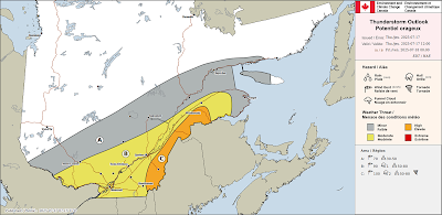
ECCC thunderstorm outlook for Thursday. Strong thunderstorms are possible in Montreal and across southern and eastern Quebec, with gusty winds the main threat.

At this time, we are not looking at a repeat of Sunday's flash flooding that occurred across the city, but some of the storms could be severe, with strong winds being the main threat. A few cells may have heavy rain, but they are expected to be moving faster than the weekend activity, therefore lowering the flood risk for Montreal. That being said, there could still be some localized water accumulation, so listen for any weather watches or warnings that may be issued later today.

A few storms may be strong enough to produce an isolated tornado or two. The main risk area would be in eastern Ontario from Ottawa towards Cornwall, Upstate New York and Vermont, as well as the Eastern Townships and Beauce regions closest to the American border.

Outside of the thunderstorms, expect another warm and humid day, with gusty southwest winds in the 30-50km/h range. Those winds will back to the north tonight.

Overnight, a refreshing air mass will arrive, with lowering temperature and humidity levels. By morning, lows may be in the lower teens. Friday will be a spectacular summer day, with sunshine, low humidity and a high of 24C (76F). Saturday will be sunny and pleasant as well, before showers return for Sunday.

Tuesday, July 15, 2025

After the flood - heat and smoke settle across southern Quebec

A film of haze and smoke from western Canadian wildfires lies across the Montreal skyline early Tuesday morning. Montreal is reporting some of the poorest air quality on the planet today, with some improvement forecast by Wednesday.

Air Quality Advisory and heat warning are in effect for southern Quebec.

After the flood comes the fire. Montreal has some of the poorest air quality in the world early Tuesday morning, as smoke from western Canadian wildfires drifts into the lower atmosphere over southern Quebec. 

As of 7AM, Trudeau Airport was reporting an unhealthy Air Quality Index (AQI) of 152, which places it 5th in the world among major cities for polluted air. We are also 5th in Canada, just ahead of Ottawa and behind Saskatoon, which has a very unhealthy reading of 239.

Combine that with elevated heat and humidity today. High temperatures will approach 32C (90F), with humidex values near 40C (104F). What does all this mean? Try to limit your outdoor activities, especially during the afternoon hours. This type of weather impacts the very old and young, as well as those with existing repository or other health concerns. The fine particulate matter from the smoke can cause difficulty breathing as well as eye, nose and throat irritations. In the worse cases, the smoke can impact breathing.

The smoke should ease later today in Montreal, but the high heat and humidity will intensify into Wednesday and persist through Thursday before relief comes in the form of a cold front. Wednesday will be the warmest day in this stretch, reaching 34C (94F). Overnight lows will be around 21C (70F).

Thursday's cold front will be accompanied by showers and thunderstorms. as with Sunday, some may be on the strong side, but that will depend on the time of day the front arrives in Montreal. Details to follow as the event draws closer.

Behind the front, much cooler, less humid air will arrive Friday, giving Montreal a much-needed break from the oppressive heat. The high Friday is forecast to be 26C (79F), and more importantly, morning lows will drop into the lower teens.

We are watching the development of what should become Tropical Storm Dexter. The system is expected to cross over the northern portion of Florida over the next day or so, before strengthening in the Gulf of Mexico. The system is expected to be a big rain maker across portions of the southern US and bears watching.

For now, stay cool.

Monday, July 14, 2025

Déjà vu all over again as flooding sweeps Montreal

Montreal experienced significant flash flooding once again, as strong thunderstorms swept across the city Sunday afternoon. The result was 50 to 100mm of rain in under 2 hours, overwhelming sewer and drainage systems. Several motorists became trapped by rapidly rising flood waters and a number of highways were closed. (Radio Canada)

Hot, humid and smokey weather expected this week in Montreal, with more thunderstorms possible. 

Heat Warning in effect for Montreal. 

Round after round of heavy thunderstorms Sunday afternoon dumped between 50-100mm of rain on the city creating widespread flash flooding once again. This is the third time in a year that Montrealers have had to deal with rising flood waters.

Sunday's flooding was courtesy of a warm, humid and unstable air mass that had been in place for several days. Introduce a frontal boundary from Ontario tapping into deep Gulf of Mexico moisture   and you have the ingredients for slow moving, very wet thunderstorms.

Strong winds and intense lightning accompanied the storms, snapping power poles along Route 138 near the Town of Mercier in the Montérégie. Over 35,000 Hydro-Québec customers lost power during the storms. (Spotted Chateauguay)

On Ile Perrot, between 2-4pm, I measured 55mm of rain. On the West Island and at Trudeau Airport, 81.7mm fell, a record for the date, surpassing the 38.6mm that fell in 2023. Some parts of north end Montreal had as much as 110mm.

The heavy rain overwhelmed the sewers once again in Montreal, flooding major highways, surface streets and scores of businesses and home from Lachine to Saint-Léonard to Kirkland and everywhere in between.

Sections of Highways 13-15-20 and 40, along with ramps and several underpasses had to be closed for varying amounts of time so vehicles could be removed and flood waters cleared.

Insurance adjusters will be out again surveying the damaged to homes as many basements flooded across the Island.

Over 35,000 Hydro-Quebec customers loss power as lines were impacted by falling tree limbs and intense lightning strikes. The storms had far-reaching effects, from south of Montreal in the Monteregie where power poles were snapped like toothpicks, to Mirabel and parts of the Laurentians where flooding was reported.

The storms come close to the July 14, 1987 anniversary of the Decarie flood. That storm officially dumped only 57.4mm of rain at Trudeau Airport, but amounts as high as 100 mm were reported in less than 1 hour in other parts of the city.

History keeps repeating it seems in Montreal. July 14 marks the 38th anniversary of the great Decarie Expressway flood.

The weather will remain very warm and humid this week, with unfortunately another risk of strong thunderstorms by Thursday. The air will also become quite unhealthy, as smoke from the western Canadian wildfires drifts into Ontario and southern Quebec. 

Wednesday, July 09, 2025

Montreal to settle into a warm and humid weather pattern

A very familiar look to the sky over Montreal this summer as the sun plays with developing cumulus clouds and thunderstorms. Montreal remains on the northern edge of a warm and humid airmass that has been delivering rounds of heat and humidity followed by strong thunderstorms. This cycle is expected to persist for the foreseeable future. (Valley Weather)

Large parts of eastern North America seem to be in a rinse and repeat cycle of warm and humid conditions, along with occasional showers and thunderstorms. This is quite typical weather for July, but what is making it different this year are the intense rain producing thunderstorms that have resulted in flash flooding in many locations.

Montreal has been fortunate to date, as most of the big wet thunderstorms have skipped the city centre. On Monday afternoon, a decent storm dumped close to 15mm on the region, producing ponding of water on highways, but little else. Trudeau Airport has measured a manageable 26mm of rain so far this month.

The balance of this week will be warm and muggy, with scattered showers and thunderstorms almost daily. High temperatures will range form the upper 20s to near 30C (80-85F), while overnight lows will be around 20C (68F). This weather pattern will continue well into next week. 

The sudden and heavy downpours make many Montrealers nervous after the deluge that flooded parts of the city last summer from Tropical Storms Beryl and Debby. The horrific images from Texas have added to the nervous emotions that exist whenever we have thunderstorms.

Most of the flash flooding we have in Montreal is caused by the inability for our sewers to handle sudden storm flows. This is very different from the circumstances that impacted the Texas Hill Country on July 4. That region has topography that is very prone to significant flash flooding, with narrow rivers channels and hilly ground. 

Heroic efforts continue from First Responders to locate victims of the horrific flash flooding that occurred in Kerr County, Texas on Friday, July 4. The death toll stands at 119 as of Wednesday morning, with 173 still missing. (Photo: Sergio Flores)

The Texas flooding is beyond catastrophic. The death toll has risen to 119 as of Wednesday morning, with another 173 missing. Intensive search, rescue and recovery efforts continue in searing heat and humidity. On July 4, between 250 and 500mm of rain fell in just a few hours, causing the Guadeloupe River to rise from a few feet to a surging 26 feet (8 metres) in less than an hour. The massive flash flood swept away homes, cottages and campers across Kerr County. The death toll includes at least 36 children.

Widespread heavy and slow moving thunderstorms have been producing flooding over many parts of the US. Major flash flooding has been observed in Texas, New Mexico, Illinois and North Carolina over the last 48 hours. Some of those wet and windy storms have crept into southwestern Ontario.

Be weather aware. As we approach the one year anniversary of the Montreal flooding, it is important to listen to daily forecasts, and especially watches or warnings that may be issued for heavy rainfall or thunderstorms. Numerous apps are available that push out weather information and warnings, including those from Environment Canada and The Weather Network.

One thing this summer is delivering across southern Quebec is plenty of heat and humidity. These weather conditions continue to fuel frequent moisture laden storms. I see no change in this pattern any time soon. Stay safe.

Monday, July 07, 2025

Thunderstorms & cooler weather for Montreal to start the week - Texas flooding

Horrific flash flooding has claimed over 80 lives in the Texas Hill Country northwest of San Antonio. Several months worth of rain fell in just a few hours Friday morning catching both holiday weekend campers and residents off guard. (Photo: Carter Johnson)

It was a tragic weather weekend in parts of Texas and the Carolinas as significant flash flooding claimed dozens of lives. The event shows just how quickly weather can turn violent, severe or even deadly. Despite the fact that weather warnings or watches often turn up empty, they cannot be ignored. Each situation is unique from the other.

On Sunday in Montreal, severe thunderstorm watches and warnings were posted for cells that turned out to be less than impressive. That happens. Summer storms form and dissipate very quickly, often in less-than an hour. While Sunday's storms were not to bad on the island of Montreal, some parts of the province did have very heavy rain, hail, power outages and wind damage.

Here in Montreal, only a few millimetres of rain fell after a steamy day. The high was 33.2C (92F), just shy of the 2010 record high of 33.6C (93F). The day was unsettled to say the least, warm and humid, a trend that is becoming all too familiar this summer across large parts of North America.

On Monday, a cold front will sag south across the St. Lawrence Valley, with significantly cooler air, along with showers and thunderstorms. Some of the storms may produce heavy rainfall. The high today will be much cooler than Sunday, reaching only 22C (72F), with brisk northeast winds. Sunshine returns Tuesday, with the high warming back up to 26C (79F). The balance of the week will remain highly variable, with temperature and humidity levels creeping back up, and a few isolated showers or thunderstorms at times.

Texas Flood Disaster

The Texas Hill Country northwest of San Antonio and specifically the Guadalupe River Valley was the scene of horrific flash flooding in the pre-dawn hours Friday morning. Several months worth of rain, between 250 and 500mm (10-20 inches) fell in just a few hours during the overnight hours. While weather warnings and updates were numerous by the National Weather Service, most residents were sleeping and caught by surprise. 

A rapidly moving wall of water swept down the Guadalupe River through Kerr County, turning the lazy river into a torrent in less than an hour. The river went from a few feet to major flood stage at over 29 feet. Flood stage is 22 feet. Residents and campers were swept away as homes and trailers were demolished. The death toll is terrible, currently at 82, including 28 children. Many of the victims were from Camp Mystic, an all girls camp on the edge of the Guadalupe. Rescuers continue to search for survivors but hope is diminishing. Resources have been pouring into the region from across Texas and the US.

The flooding occurred as an area of slow-moving thunderstorms tapped into deep Gulf of Mexico moisture producing torrential rain over the central portion of the state. Flooding in ongoing Monday morning in Texas.

Flooding is also occurring in North Carolina, as the remains of Tropical Storm Chantal move inland after making landfall along the South Carolina coast Sunday.

Thursday, July 03, 2025

Thunderstorms and muggy weather persist over southern Quebec and Ontario

Mother Nature put on a show in Laval and across the Montreal region on Canada Day, with regional fireworks displays sharing the sky with rainbows and lightning. (Photo T. Tsoukatos)

Severe Thunderstorm Watch for eastern Ontario and southern Quebec through Thursday evening.

Some storms have fired up in the muggy airmass located across southern Quebec on Thursday, but the bulk of the severe weather so far has been across northern New England. Partly cloudy skies will make the atmosphere unstable again Thursday afternoon across the region. The main threat would be gusty winds and heavy rain along with dangerous lightning.

Warm and humid air has prevailed across southern Quebec since the June 24 holiday. Temperatures have been warm, combined with elevated humidity at times. The result has been numerous showers and thunderstorms scattered across portions of Ontario and Quebec, typical summer weather.

Canada Day was extremely muggy across the region, with strong thunderstorms developing during the late afternoon and evening hours. The same was true on Wednesday evening, with thousands of lightning strikes reported between Ile Perrot and the Ontario border during the evening hours. There were reports of several homes being struck by lightning as well as power outages. Small hail was also observed.

More unsettled weather is occurring on Thursday, as a cold front slides across the region. Any thunderstorms will prevail into the early evening hours before dissipating near sunset. As winds turn out of the west, some smoke and haze may drift into southern Quebec from the western Canadian wildfires. Most of the smoke should remain in the upper atmosphere, resulting in hazy conditions.

Friday through the upcoming weekend and into Monday will feature more warm and humid weather. Friday and Saturday look dry, with highs around 27C (81F). Both temperatures and the humidity will be on the rise Sunday and Monday, closing back in on 30C (86F), with an increase risk of showers and thunderstorms from late Sunday into Monday as a frontal boundary sags southward into New York and New England.

Temperatures may cool briefly in Montreal on Monday under clouds and showers, but quickly warm back up again by Tuesday.