Tuesday, April 30, 2013

A few early showers for Montreal

Weak low pressure continues to provide southern Quebec and Ontario with cloud cover and a few showers. I was rather surprised to see the rain this morning, but it will be short lived with partly cloudy skies coming back by 10am. More clouds than sun this afternoon in Montreal with high temperatures up to 21C. Wednesday and Thursday will be spectacular with highs around 23C and lows near 10C. Nothing but sunshine is expected right into this weekend with warm temperatures.

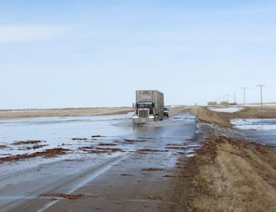
Water rushing across Highway 2 south of Moose Jaw, Saskatchewan as spring flooding begins. (Regina Leader-Post)
Alberta snow
Yesterday a cold winter like system spread snow from Alberta into eastern portions of Saskatchewan. As much as 15cm of west snow fell in portions of Alberta. This morning it is a cold -5C in Edmonton with flurries. The snow today will fall from the Lakes region of Manitoba into extreme northwest Ontario. Travel will be very poor in gusty winds and wet snow today in those regions.

Spring flooding has begun in parts of southern Saskatchewan, with water running over Highway 2 south of Moose Jaw as well as flooding several properties around Ketepwa Lake. The deep snow pack this winter will result in flooding across many regions of Manitoba and Saskatchewan this Spring. Major flooding is also occurring south of the border in North Dakota in Minot and Grand Forks.

Monday, April 29, 2013

Spectacular spring week ahead

Hydro crews work on a near perfect Sunday to repair damage from a fallen tree on L'Ile Perrot.
It was just a perfect late April weekend in Montreal with temperatures either side of 20C, no precipitation and abundant sunshine. Despite this I managed to lose power for 6 hours on Sunday after a tree fell on a power line on my street. The woods behind our homes have taken a beating this winter right up to last weeks high winds. I guess the tree chose the nicest day of April to finally give up!

As far as this week goes, a few clouds and perhaps a shower are around today as the remains of a week low move from Ohio across upstate New York. Once this cloud moves east, strong high pressure will develop for the remainder of the week with no precipitation and warm temperatures around 21C (70F). Lows will be mild as well no colder than 5C. With low relative humidity and the drying sun, we will have to watch all outdoor burning as the fire risk in Ontario and Quebec will be on the rise.

It won't be perfect everywhere. Some portions of the northern plain states into southern Manitoba and northwest Ontario could see some snow this week. Wet snow is even forecast for Edmonton today with a high of only 3C. Warnings are already in effect for up to 15cm of snow in the inter-lakes region north of Winnipeg.

Thursday, April 25, 2013

Windy overnight - clearing today in Montreal

A very slow moving cold front finally arrived in Montreal during the wee hours of the morning today along with strong winds and rapidly dropping temperatures. All day yesterday the rain fell across southern Ontario with temperatures in the cold single digits between 3 and 6C. There was even some wet snow in places like London and Wiarton. Meanwhile Ottawa reached 18C and Montreal 22C on warm southerly winds. That changed around midnight when the front moved across the St. Lawrence Valley. The temperature fell to where it sits this morning at 3C here in Montreal. Winds were strong across the region  with several gusts reported at Trudeau in excess of 80km/h with a peak at 2am this morning of 83km/h. The wind was responsible for power outages to nearly 10,000 Hydro Quebec subscribers, mostly off island to the north of Montreal. Of note, due to the location of my anemometer, my highest reading was 45km/h. This is something I will be taking a look at this summer, possibly finding a better location.


Rain along the front here on L'Ile Perrot was much more spotty than in Ontario. We only recorded between 3 and 5mm, southern Ontario on the other hand recorded between 10-20mm. Skies will slowly clear out today with blustery winds and much cooler highs of around 11C. The weekend at this time looks warmer with temperature inching back up to above normal, perhaps into the 20's by Monday.

Wednesday, April 24, 2013

Warm day in Montreal - still snow in places

Highway 17 in northern Ontario at a standstill on Tuesday as winter just won't go away.
High pressure will give southern Quebec one more sunny and warm day today before a cold front crosses the region this evening. The temperature this morning is between 5 and 8C in most locations, the warmest of the week so far. Warm southerly winds ahead of a cold front will help push daytime highs close to 21C (70F) across eastern Ontario and extreme southern Quebec. Showers will develop by this evening here in Montreal with a general rain overnight. Look for up to 15mm of rainfall for most areas, there may even be some wet snow across the Ottawa Valley behind the front by morning. Winds will increase as well as the cold front nears Montreal, coming out of the southwest up to 50km/h and gusting to 70km/h overnight. After 21C today temperatures will fall rapidly overnight to near 2 or 3C by morning and rise slowly on Thursday to 10C. Across the Pontiac region, heavy rain warnings are in effect for 25mm of rain, while even further north in Chibougamou snowfall warnings are flying for up to 25cm of snow.

Record Cold Temperatures
As noted above this system has a cold side to it that continues to produce snow north and west of the system. After dumping more snow across Minnesota and the Dakotas, the storm took aim on northern Ontario on Tuesday. Several centimetres of snow and ice forced the closure of several highways including the Trans-Canada east of Thunder Bay along the Lake Superior shore. Record cold has plunged as far south as Texas with Dallas at a record low 4C (40F) this morning. At first pitch it was only -5C (23F) at Coors Field in Denver yesterday. The doubleheader between the Braves and Rockies was the coldest game ever played there.

On Monday the morning lows were -13.1C in Regina, Sask and -11.1C in Saskatoon making it the coldest April 22 in 104 years. That is just how cold this spring has been. Montreal reached 14C yesterday which is normal for the date, but the month as a whole has featured more than half the days below normal. If we hit 20C today it will be only the second time this year
we have made it above 16C (60F).

Monday, April 22, 2013

Cold start in Montreal...again

Happy Earth Day

Winter just won't let go here in Montreal and across a big portion of the country. While the last of the snow has melted away, it remain very chilly for late April. Temperatures over the weekend struggled to clear the single digits with periods of snow showers on Saturday. This morning we dropped to -3C with yet another widespread frost and freeze. Temperatures under sunny skies will warm back up to 13C today here in Montreal. It will be a decent week with showers forecast for Wednesday but otherwise dry. Temperatures will continue to be at or slightly below normal with highs in the 13 to 17C range and lows warming from 0C tonight to plus 5 or 6C for the balance of the week. The rain Wednesday will be along a cold front. That same system will bring more showers to the waterlogged Midwest and central Ontario.

Major flood waters inundate a home on Sunday near Burnt River, Ontario north of Lindsey. (CTV News)
The big weather story this weekend came from the aftermath of last weeks storm. The major low pressure that swept from the southern plains across the Midwest produced 1 to 3 inches of rainfall from Missouri into Ontario. That combined with rapid snow melt is producing major flooding from the Dakotas across Illinois and into the Ohio Valley. The flooding has also extended in central Ontario. Cottage country north of Toronto around Bracebridge, Huntsville and Kawartha Lakes has been hard hit with near record flooding. Several central Ontario communities have been declared disaster areas after the flood waters destroyed homes and washed away roads over the weekend.

First Tornado
Environment Canada has declared that the strong thunderstorm that produced damage near Shelburne, Ontario last Thursday spawned the first tornado of the 2013 season in Canada. The storm was an EF-1 capable of winds in excess of 135km/h up to 175km/h. The tornado downed hydro lines, poles, trees, and tore the roof off a barn.

Friday, April 19, 2013

Mild Friday - colder weekend

What a crazy week it has been and as I write this I have one ear on WBZ radio in Boston while I try to compose the blog. Lets hope this ends soon. Boston Strong, hang in there.

Major flooding has occurred across portions of Illinois over the last 24 hours. (WGN)
In Montreal, Ontario and Quebec, temperatures will make a big swing from well above normal today to below normal for the weekend and well into next week. We start the day around 12C on our way to 20C, the warmest day of 2013. Temperatures around the area will be even warmer with strong south winds in the Richelieu and Champlain Valley pushing highs there into the 20's.

A strong cold front has been the focus for heavy rain and thunderstorms from Illinois into portions of Michigan and Ontario. Heavy rain has caused widespread flooding in the Chicago metro region. Rainfall warnings are in effect for a big chunk of Quebec but not here in Montreal. West of the low pressure area very cold air for April has produced another big snowfall from the Rockies across portions of Minnesota into northwest Ontario. Some of that cold air will help fuel thunderstorms for portions of Ontario today with the front arriving in Montreal tonight. Showers can be expected with temperatures falling to 5C tonight as the cold front moves through. The weekend looks chilly with showers or maybe even a snowflake Saturday and only 6C. Some sunshine and a little milder by Sunday up to 9C. Winds today will become gusty out of the southwest up to 60km/h across Ontario and into the St. Lawrence Valley.

Wednesday, April 17, 2013

Has spring finally sprung in Montreal?

A wonderful sight each Spring on L'Ile Perrot, the street cleaner picking up the tons of dirt left behind by winter. (ValleyWX Pic)

The last patch of snow disappeared from my front lawn at 6:05 pm yesterday evening and I was ready, rake in hand. It is an annual right of spring to get outside and make the property look good after the winter snow and cold has destroyed the lawn. There is also a ton of sand and small rocks left behind from the plows and salt trucks.

So is spring finally here? It would appear so with mild weather in Montreal and downright warm weather forecast for Friday. Temperatures today have already reached 10C and we should peak around 12C or so, very close to normal. A major storm has developed over the US southwest and will move towards the Great Lakes by Friday. This system will produce another wild mix of snow and tornadoes from New Mexico to the Ohio Valley. The snow will be confined to the regions west of the track. That will include South Dakota and Minnesota that were hard hit by back to back April snowstorms already. It will also spread snow into northwest Ontario and portions of central Quebec. Montreal this time will remain south and east of the track. This will allow a surge of warm humid air into the region by Friday. Partly cloudy skies and gusty south winds should push the temperature into the low 20's in the St. Lawrence Valley. There is even the risk of a thunderstorm or two.

The weekend looks much cooler with temperature back below normal, but no snow! Hopefully that is it for snow for 2012/2013. The ground was covered at my house from early December right through April, long enough.

My thoughts and prayers are with the victims, First Responders and people of Boston. Stay strong.


Tuesday, April 16, 2013

Mild & showery Tuesday in Montreal

A slow moving cold front is centered across Ontario this morning with radar showing a general area of rain in the Ottawa Valley. The bulk of this moisture should remain north of metro Montreal until this afternoon until the front gets a little closer to the valley. Today will be showery but mild across the region with temperatures already at 9C and highs forecast around 13C. Cooler tonight behind the front with lows down to 1C. Wednesday will be sunny and mild again with highs at least 12C. A warm front will approach the St. Lawrence Valley on Thursday with a surge of mild and moist air. Look for showers late Thursday and Friday and even some thunder, but warming up to around 20C on Friday, which if it occurs, will be the warmest day of 2013 to date. The weekend looks cooler but dry, time to begin cleaning up the debris left behind by the winter.

Monday, April 15, 2013

Spring arrives in Montreal this week, 20C by Friday

Snow in April in Montreal. Over 10cm fell on Friday here on L'Ile Perrot. It has since melted. (ValleyWX Picture)
We had nearly 13cm of wet snow on Friday here in Montreal, along with several hours of ice pellets and freezing rain. It was a nasty day with ice covered roads and just plain raw. This morning is cold with frost as we start at -2C. That is the bad news, the good news is all the snow has melted and we are in for some spring weather, finally this week. It starts today with sunny skies through increasing clouds and temperatures warming into the 11 to 13C range. A cold front will approach the region early Tuesday with showers and perhaps some thunder. It will remain mild tonight around 8C and slightly cooler Tuesday, perhaps 10C with gusty southwest winds and showers.

By Wednesday into the end of the week the region will come under the influence of yet another big late season storm moving from the Rockies towards the Great Lakes. This one however will pass well northwest of eastern Ontario and southern Quebec leaving us in the warm sector. Temperatures will climb from the teens into the low 20's by Friday in Montreal with partly cloudy skies and showers.

Winter held on across North Dakota as it has in so many places this year with a record breaking 20 plus inches of snow in Bismark yesterday. The storm created blizzard conditions forcing authorities to close Interstate 94 from Montana to Minnesota as well as Interstate 29 from north of Fargo south towards South Dakota. The snow this morning is spreading into northwest Ontario with 7cm already in Thunder Bay.

Bismark, North Dakota with  one of its snowiest April days on record yesterday.

Friday, April 12, 2013

Icy - slow travel in Montreal

Above & Below: A snowy April day in Pointe Claire. (ValleyWX Photos)
Visibility has been under 1km in moderate snow in Montreal for a couple of hours. Roads are snow covered with very poor travel. We had freezing rain and sleet prior to the snow, so roads are slippery. Radar is showing several more hours of mixed precipitation ahead of us, so this April storm is far from over. Drive safe.
 

Storm on track for Montreal & southern Quebec today

Southern Ontario this morning (The Weather Network via Twitter)
Freezing rain in Toronto overnight. (CBC News)
Winter Storm Warning - Montreal, Ottawa, Toronto
If you can avoid big travel today, then do so. Don't be fooled by the quiet this morning here in Montreal, heavy winter precipitation is on our doorstep to the southwest. A wide area of precipitation will settle over southern Quebec for the next 24 hours with mostly snow, but a nasty mix of freezing rain and sleet from Montreal south. Accumulations will vary widely, as is common in April and with these types of storms, but look for 10-20cm from Montreal to Ottawa south to Cornwall and also points east to Quebec City and Sherbrooke. Travel will become difficult today as it has been in southern Ontario overnight. Steady freezing rain around the GTA and eastern Ontario overnight has prompted school closings, power outages, flight delays and numerous accidents.
Winds will be cold and gusty out of the northeast up to 50km/h in Montreal and temperatures will be either side of 0C. By Saturday slightly warmer air will change any remaining precipitation to rain with highs around 7C.

This storm has been bad with record breaking snow and freezing rain to the north and west as well as severe weather with tornadoes south of the system. Low pressure over Ohio will move east over New England today and then eastward into the Atlantic Saturday. Travel with great caution today or put it off until tomorrow.

Thursday, April 11, 2013

Major storm heads for Ontario & Quebec

A very unusual sight for April in Wisconsin as a major ice storm sweeps portions of the upper Midwest and Ontario.
SNOWFALL WARNING: Montreal & southern Quebec 15-25cm
WINTER STORM WARNING: Toronto, Ottawa & Eastern Ontario10cm & Freezing Rain

As I mentioned at the start of the week, this storm was going to be a big news maker  and it has been. From heavy snow to an very unusual April ice storm to severe weather and tornadoes this storm has it all. Record cold is on the north and west edge of the storm while record heat has surged north on the east side of the storm. In between, a mess.

At this time, all of southern and eastern Ontario are under winter storm warnings for a wide range of weather including snow and ice. What you need to know this morning is that low pressure over Illinois will move northeast to near Lake Erie by Friday morning. A large area of precipitation will begin moving into marginally cold air at the surface this morning producing a wide area of freezing rain from Toronto to the Ottawa. Northern areas closer to the Ottawa River will see more snow than rain. Precipitation will spread into the GTA this morning and the rest of the province by late tonight, reaching Montreal after midnight. In Quebec, warnings are confined to the Gatineau and regions well north of Montreal for the time being. Those areas will see about 20cm of wet snow. Montreal and most of southern Quebec will have a sleet and snow mix with temperatures at the freezing point. Look for up to 10cm in Montreal with more over any elevated terrain. Winds will be strong out of the northeast from 30-60km/h across the St. Lawrence Valley. It will be cold with highs near 0C. There will be enough snow and ice to disrupt travel from late today across the GTA through most of Friday into Ottawa and Montreal. Power outages are a real threat from central southern Ontario into the Ottawa Valley.

The same storm produced widespread severe weather including a tornado in the St Louis suburb of Hazlewood.
Last night this same storm produced more severe weather with several tornadoes in Arkansas and Missouri
 destroying numerous homes.
Wednesday, April 10, 2013

Strong storm highlights April contrasts

Over 20 inches of snow fell in Rapid City, South Dakota on Tuesday. The storm is heading east towards Ontario by late Thursday.
A very intense low pressure area spinning its way from Colorado towards the Great Lakes is highlighting just how changeable April can be. On Monday, Denver reached 72F, while yesterday they recorded there coldest April 9 on record, a full 50 degrees colder at 22F. Meanwhile in the Texas Panhandle, strong winds, snow and ice were falling with temperatures at -1C while in Laredo on the Mexican border it was 106F. Strong thunderstorms were occurring in Nebraska and Kansas while temperatures were below freezing! Winnipeg recorded its 20th straight day of below normal temperatures and record lows were set in Saskatchewan. Heavy snow was falling along the northern edge of the storm with nearly 2 feet in Rapid City, South Dakota. Warnings and watches now stretch from southwest Ontario to the plains states. Heavy rain is expected along and to the south of the track with flooding possible from Missouri to Ohio.

Meanwhile on the warm side of the storm the first heat of the year pushed northward into New Jersey and New York with highs in the low 80's including a record high of 85 in Newark. Boston reached into the low 70's before a sea breeze cooled it back into the lower 50's.

Montreal snowstorm?
What does all this mean for Montreal? Well our unsettled week will continue with temperatures today around the 8C mark for a high. Some showers are possible with mostly cloudy skies. On Thursday the region will begin to feel the effects of the Colorado storm with winds increasing out of the northeast and a cold high of 1 or 2C. Wet snow is expected overnight into Friday across a wide area from Ottawa to Quebec City and portions of the St. Lawrence Valley. At this time is is a little early to nail down amounts, but some areas could see in excess of 15cm while others close to the US border may just have a very cold rain. In Ontario a winter storm watch is already in affect for the southwest where rain will mix with and change to freezing rain late Thursday with significant icing possible. Already lots of freezing rain along the path of this storm with trees and power lines down. We will need to tweak the forecast over the next 24-48 hours so stay tuned. Friday may be a no travel day in the area.

Tuesday, April 09, 2013

Powerful winter storm developing - snow for Montreal?

Traffic camera near Riverton, Wyoming this afternoon showing heavy snow.
A very intense low pressure area fueled by warm air from the Gulf of Mexico and unseasonably cold air from the Prairies will take shape over Colorado today. This storm created some wild temperature swings on Monday over the high plains with 80's in New Mexico and 20's in Wyoming with heavy snow. Denver dropped from 72F at 3pm Monday down to 41F in less than two hours with blowing dust and a thunderstorm. Snow spread into Denver after midnight, just an incredible swing in temperatures as they sit at 16F this morning with windchill readings near 1F (-17C). At the same time last night large thunderstorms were occurring across eastern Colorado and into Kansas with hail and several tornadoes.

This storm will continue to gain strength as it moves across the Midwest and into the Great Lakes by Thursday. It will then slide east across New England on Friday. At this time a swath of heavy snow is expected across the Dakotas and into Minnesota and Wisconsin with easily over 1 foot. The snow may affect portions of Ontario and Quebec by late in the week. This storm will be a news maker with travel disruptions and power outages expected along its path. Heavy rain and severe weather with some tornadoes will occur along and to the south of the trajectory. Depending on the track of the storm, Montreal may see a messy mix of snow and cold rain on Friday along with strong winds.

Monday, April 08, 2013

April showers bring May flowers

It will be a wet week in Montreal and across the entire region as a frontal boundary becomes the pathway for several low pressure areas. The first will begin to affect the Montreal region tonight, but before that we have a partly cloudy and mild day with highs near 12C (54F). We start the day at 4C here on L'Ile Perrot after a few showers Sunday. Rain will move into the region again tonight and taper off by noon on Tuesday. I expect about 15mm through the period. More rain is forecast to arrive by Wednesday and that will last into Friday. There may be a little wet snow on Friday but it does not look like much at this time. Winds will be gusty late in the week.

Today low pressure is getting organized in the Rockies, and this system is expected to generate a significant spring snowstorm over portions of the high plains and Rockies, including Denver. A rapid weather change is forecast in Denver with highs of 18C (65F) today dropping well below freezing by Tuesday with heavy snow and strong winds. I have seen this happen first hand when I was in Saskatchewan and it is quite a shock to the system. In the spring of 1999 in Gravelbourg during May of all months, we went from the mid 20's down to below freezing in less than 12 hours with rain changing to wind driven snow.The same storm system will generate strong thunderstorms with tornadoes and hail over the central and southern plains from Missouri to Texas.

Friday, April 05, 2013

Half & half weekend for Montreal

Not an exciting picture, but neither is snow in April! I was surprised to see more snow falling outside my window this morning. I keep hoping this will be the last time for winter 2012/2013. A dusting is expected as a weak cold front crosses the city. (VallyWX)
It will not be a perfect weekend, but better than most of the week has been. This morning to top off what has been a blustery, cold week, we have light snow falling in Montreal. A weak cold front is lying over the St. Lawrence Valley with just enough lift to produce light wet snow across the western end of the city. Temperatures are right around the freezing point so most of the snow is melting with the exception of grassy surfaces, cars and the remaining snow piles. The precipitation will taper off soon with an increase in sunshine and gusty winds as well. Temperatures will slowly recover today to around 5C. The weekend will feature high pressure and chilly temperatures for Saturday, perhaps 5 or 6C. The abundant sunshine will be a welcome sight, but it will be short lived. A potent warm front will lift across the region overnight Saturday into Sunday with a mix of rain and snow at the onset, switching to all rain by Sunday morning for eastern Ontario and southwest Quebec. Temperatures will warm to 10C on Sunday with gusty winds up to 50km/h from the southwest. Looking into next week, temperatures will be near normal, but several opportunities for rain are expected.

Thursday, April 04, 2013

Slow spring warming trend

Hail did major damage in Hitchcock as storms flared across central Texas late Tuesday night. The hail, the size of softballs, punched out windows and damaged homes. The storms were part of a larger system spreading rain and strong winds along the Gulf Coast. This storm will remain well south of our region.
Warmer air is in our future as we slowly begin to emerge from this windy cold pattern that has greeted us to start April. Winds have been very strong since Monday, generally in the 20-40km/h range but gusting during the daylight hours to well over 70km/h. Today will be no different with winds increasing once again up to 70km/h, but this time from the southwest. Slightly warmer air and a little more sunshine will push highs into the plus 7 to 10C (45-50F) range. This is a vast improvement form the -1C on Tuesday and Wednesday's 2C in Montreal. It has been a dry week with just a few flurries around. The snow has been confined to the area around the Great Lakes with several centimeters in Barrie, Ontario, and over 25cm in Syracuse, NY on Tuesday. The snow cover in Montreal has now dwindled to just some remaining piles on the lawns and parking lots, more here in the suburbs - nothing downtown. Lots of evaporation this week with the wind, so very little water around.

Partly sunny skies today will give way to some clouds on Friday before another sunny day Saturday. After that several low pressure areas will begin to impact the St. Lawrence Valley with showers expected by late Sunday, and a general rain (perhaps as much as 25mm) on Monday into Tuesday. Temperatures are on the rise with highs reaching the double digits by Monday, up to 13C (55F). Looking ahead much milder air is expected by the second and third weeks of April with temperatures finally warming to above normal values.

Tuesday, April 02, 2013

Cold start to April in Montreal

Strong northwest winds behind an arctic front produced gust to 76km/h in Montreal late Monday and have driven in much colder air across southern Quebec. Monday started around 5C but by the supper hour it was below freezing with flurries and strong winds. The record low for April 2 is -8C in Montreal, we are currently at -7C at the airport. Gusty winds in the 35km/h range are producing windchill values between -9C -15C. Skies for the time being are clear here on L'Ile Perrot but deep cyclonic moisture and the daytime sun should rapidly produce cloud cover along with snow showers. Look for a dusting in the city to as much as a few centimetres across the higher elevations of the Laurentians and Townships and into New England and New York. Keep this in mind if your travels take you down Autotoute 10 or Interstates 89 & 91.

Temperatures will remain chilly today with highs no better than -3C or about 10 degrees below normal. It will remain cold tonight dropping to -6C and only up to -1C on Wednesday  Milder air should return by Thursday with temperatures back to a near normal high of 7C. Winds will remain gusty today across the St. Lawrence Valley in the 40-60km/h range.

The Detroit Tigers Cecil Fielder tries to warm up before yesterdays game in Minnesota against the Twins. It was only 35F (2C) at game time. The Tigers beat the Twins 4-2. (AP Photo)
Cold MLB Opening Day
The boys of summer are back, thankfully, as major league baseball regular season action got underway on Monday. My Red Sox beat the dreaded Yankees 8-2 but the real story across many ballparks was the near record cold. It was the second coldest opening day on record in Minneapolis for the Twins as well as the Brewers in Milwaukee. Temperatures at game time were around 35F about 15 degrees below normal, add in the wind and it was below freezing at many venues. We will have a slow warming trend this week so the weekend games should be much warmer!

Monday, April 01, 2013

April - the month of transition

Spring has been slow to arrive across most of Canada this year, in stark contrast to 2012. This is a scene from Gravelbourg, Saskatchewan where multiple blizzards and a cold March have left tones of snow. My good friend and Editor of the Gravelbourg Tribune, Paul Boisvert sent me the photo.
April is upon us with all its uncertainty and surprises in a month that can feature raging snowstorms or summer like warmth. We often see out first thunderstorms of the season and more often than not the tulips and trees will begin to sprout. An example of the wide range in weather can be seen by peeking at the record books for April 1. On April 1st, 1986 we had a record high of nearly 26C (79F) while in 1993 we had 31cm (12 inches) of snow. You get the idea.

That being said it does not look very springlike this week. After a rather mild end to a cold March we are looking at a strong Arctic cold front crossing Ontario and Quebec today. Currently Montreal is 4C (39F), which should be our high for the day. The front is crossing eastern Ontario this morning with Ottawa still at 4C (39F) but Toronto down to -1C (30F). Winds will increase out of the west up to 60km/h along with scattered showers and eventually flurries. Some snow squalls may even develop briefly north of the city and across the Adirondacks and western counties of New York. Lake effect snow is also possible around Georgian Bay and south of Watertown, NY.

Temperatures are at there warmest right now than they will be for most of the upcoming week. They will tumble down to around -5 to -7C tonight and only rise to -1 to -3C on Tuesday, a full 6-10 degrees below normal for early April. Unsettled weather is expected for most of the week with scattered flurries likely. We managed to loose lots of snow cover over the past week, especially on south facing properties. My backyard is down to a thin layer, but the front yard still has 1 to 2 foot piles of hard packed, icy snow, the stuff that takes forever to melt. Depending on where you live in metro Montreal you may have nothing left in your neighborhood. On L'Ile Perrot however we don't haul away the snow, we just pile it up. It takes a little longer for spring to come here.