Saturday, December 31, 2022

Foggy end to 2022 in Montreal - Happy New Year

Dense fog made travel tricky across southern Quebec and Ontario on New Year's Eve. Widespread fog advisories are in effect for the entire St. Lawrence Valley tonight. Travel with care, especially off island. (Valley Weather Photo)

Happy New Year! Thank you for reading, I appreciate your time, 2023 will be my 44th year, talking and writing about the weather.

We end the year on a foggy note across southern Quebec. The fog has been thick most of the day, with Trudeau Airport reporting less than 1 kilometre visibility for 10 consecutive hours. The visibility has come up a bit at the airport over the last two hours, but the fog remains thick off island and near any body of water. A fog advisory remains in effect for most of southern Quebec, extending into eastern Ontario.

A slow moving cold front has produced close to 10mm of rain today here on Ile Perrot. Rain, fog and drizzle will persist into the overnight hours and early New Year's Day, before cooler and drier weather arrives. The front will eventually slide south of the region on Sunday.

The high in Montreal today was a very warm 7C (45F), temperatures will slowly fall over the next 24 hours down to -1C (30F) by Monday morning. More active weather is on the way next week, along with a return of much colder air by Thursday. More on that next year. Have a safe New Year's Eve.

Foggy, damp December 31st in Montreal and southern Quebec

It is a very foggy, damp morning on Ile Perrot this December 31st, with the temperature well above freezing at 6C. A fog advisory is in effect for Montreal, with visibility under 1km in many locations. (Valley Weather Photo)

Happy New Year!

Widespread fog advisories are in effect for a large portion of southern Quebec and Ontario, including metro Montreal Saturday morning. Visibility in many instances is well under 1km, down to just a few metres at times. Drive with great care if you have any travel plans today. Saturday will be very mild as we say goodbye to 2022. Temperatures overnight remained well above freezing, currently at a record setting maximum low of 5.9C (42F) here on Ile Perrot. The normal low is -14C (14F). The daily high will fall short of the record today, which is 12.2C set in 1965.

Friday was warm and wet, not your typical late December day in Montreal. Dozens of record highs were set across southern Quebec, Ontario and New England. In Montreal a 133 year old temperature record from McGill University fell as the mercury soared to 8.6C (48F) surpassing the 1889 record of 7.8C (46F). The overnight low tied the record from 1884 at 3.9C (39F). Ottawa also set a new record high at 9.8C (49F) beating the old daily high of 6C (43F) set in 1990. Warm air moved all the way north into the lower Laurentians, with Mont Tremblant reaching 7.4C on Friday, with 27mm of rain. Not very good for the ski hills!

The warm weather will persist Saturday as we reach 8C (47F) before the rain sets in along a cold front late today. The slow moving front will cross the St. Lawrence Valley this evening, ushering in slightly colder air for New Years Day. Temperatures will fall slowly today towards the freezing point on Sunday. Rainfall will amount to 10-15mm across the region today into tonight. The snowpack has dwindled down to just a few centimetres in Montreal.

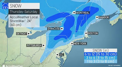
The slightly cooler air Sunday will be short-lived, as another surge of very warm air and rain arrives by Tuesday. On the backside of the next system, much colder, more normal temperatures for January will arrive. It will not be frigid, but it should be cold enough for the rain to change to snow Wednesday night into Thursday morning.

Drive safe and enjoy your New Years Eve.

Friday, December 30, 2022

Record warmth and rain across southern Ontario and Quebec to end the year

The current thaw is making a mess of area roadways. There are plenty of large potholes hidden by deep puddles in some cases. The temperature roller coaster we have been on so far this winter is hard on everything from roads, to homes, cars, animals and even us!

In stark contrast to last Friday in Montreal, today was warm and wet, with record high temperatures established in many locations across Ontario, Quebec, New York and New England. Montreal reached 7.2C (45F) breaking the record at Trudeau Airport of 6.1C (43F) set in 1965. The record from McGill was 7.8C set all the way back in 1889. I managed 9.4C (49F) here on Ile Perrot. Toronto managed 13C (55F) smashing the 1965 record of 7.2C (45F). On Thursday, just one day after 15cm of snow, Ottawa reached 7.5C, breaking the 2018 record of 6.6C.

To our south, Massena and Cornwall reached 11C (52F) surpassing the record of 49F set in 1990. Burlington, Vermont smashed there daily high temperature record, reaching 14C (58F). The old benchmark was 11C (51F) set in 1990. As the day ends, a more complete list of records will show just how warm this airmass is. Keep in mind that the upcoming couple of weeks are typically the coldest of the year in Montreal.

The roller coaster ride is the result of strong low pressure passing well northwest of our region. A surge of warm air has moved north from the southern US. Temperatures will remain very mild overnight, with rain developing as a cold front moves into the region. The low is expected to remain fairly steady around 7C, which would set a record for the warmest overnight low for the date. As is stands, you have to go back to 1884 in Montreal for the previous max low record of 3.9C, so this is quite the event. 

Along with the warm air has been a rapid melting of the snowpack. Montreal had received 63cm of snow this month, most over the last two weeks. As of last evening, 16cm remained on the ground at Trudeau Airport. A large amount has vanished in the warm south winds over the last 36 hours, and most should be gone in Montreal by New Years Day.

In terms of practical weather, expect light rain and fog Friday night into New Years Eve. As the slightly colder air arrives late Saturday night and Sunday, a few flurries are possible. Expect more very warm air on Tuesday and Wednesday, accompanied by rain. Colder weather is expected to return on or about January 6.

The normal high/low for Montreal for late December is -5C/-14C.

Wednesday, December 28, 2022

Surge of warm air expected in Montreal to end 2022

Roads across southwestern Quebec were terrible during Christmas Eve and Christmas Day, with strong winds creating slick travel and reduced visibility. Several roads were closed across the region. (Service de sécurité de Sainte-Barbe) 

After the fierce storm that impacted so many through Christmas, we are in for a very warm end to 2022. In what has become so common in Montreal winters of late, temperatures will swing back above freezing for an extended period beginning Thursday. Temperatures through at least January 6 are expected to be well-above normal and above freezing. We may see daytime highs as warm as 10C (50F) during the thaw and even overnight lows remaining above freezing. The warm air will affect a large portion of Quebec and Ontario. This will allow all the ice and snow of the last week to melt away. There is rain forecast as well for New Years Eve and day, some flooding is likely. Authorities are reminding everyone to stay off and away from any body of water in southern Quebec. The ice will become extremely unstable, along with an increase in water flow during the upcoming thaw.

It certainly was a very wintry Christmas week across Quebec and Ontario, after an historic snowstorm moved slowly across the region. Montreal was on the "gentler" side of the storm, with plenty of rain preceded and followed by heavy snow, wind and cold. In the city, around 25cm of fresh snow has fallen over the last week. This brings the seasonal total to 72cm (28.3 inches). Now compare that to hard-hit Buffalo, New York, that has measured over 100 inches (254cm) of snow this winter to date. Much more snow fell north of Montreal, with some locations measuring over 50cm.

The intense winter storm cut power to nearly 700,000 Hydro-Québec customers over the busy holiday period. Nearly 18,000 still remain without heat and light Wednesday morning. Many of the outages, like the one shown above, impact only a few clients and have been difficult to reach for the utility. (Hydro-Québec Photo) 

In Buffalo, a state of emergency remains in place as authorities clear up the abandoned cars, open roads and sadly count the dead. The death toll in Erie and Niagara Counties in Western New York stands at 35, 27 in Buffalo alone. This surpasses the terrible Blizzard of 1977 that resulted in 29 fatalities across the region. At least one death was reported in Ontario.

Back to Quebec, the power remains out to over 18,000 Hydro-Quebec customers Wednesday morning. Some have been in the dark and cold since late Friday. The utility is down to the difficult portion of the recovery now, with smaller outages affecting only few customers at a time. Thousands of line workers have been on the job 24-7 since the storm began.

Powerful winds gusted between 90-130km/h in the province, with 16 consecutive hours of blowing snow recorded at Trudeau Airport. Six more hours of visibility under 1km were reported at the airport in Dorval on Christmas Eve. Conditions were much worse off-island. The blizzard conditions impacted a large area of Ontario and Quebec, with hundreds of kilometers of highways closed during the busy travel period across both provinces.

The storm also produced record high storm surges along several of the Great Lakes and the St. Lawrence River from Quebec City towards the lower north shore. This included 7.15 metres in Old Quebec City. The tidal surge produced significant flooding and damage in many locations.

The wind also caused significant damage to trees, power lines and even some structures.

The good news is that mild weather is expected across the entire area impacted by the storm, allowing for recovery efforts to continue, likely at a faster pace.

Sunday, December 25, 2022

Powerful winter storm to ease grip on province Sunday

 Hydro crews continue to work throughout the holiday in difficult conditions. While power has been restored to many, over 136,000 customers remain in the dark and cold Christmas morning. The utility is aiming for Tuesday to have most power restored. The hardest hit area remains the Quebec City region, with over 40,000 in the dark. Quebec and parts of the lower Saint Lawrence were hit with winds in excess of 120km/h. (Hydro-Quebec Photo)

Merry Christmas! Conditions are improving today, but travel with great care as many roads remain quite challenging.

The powerful winter storm that has hammered parts of Quebec, Ontario and New York since late Thursday, will begin to relax its grip for some today. A late issued blowing snow advisory is in effect for southern Quebec Sunday, with difficult travel conditions across many off-island locations. A few remaining snow squalls may make their way into southern Quebec today with perhaps a centimeter or two, but conditions should begin to improve.

The storm is now located east of James Bay moving slowly northeast while gradually weakening. In its wake, we still have over 136,000 Quebecers in the dark and cold Christmas morning, some without power for over 36 hours and counting. Hydro-Quebec crews continue to battle strong winds and drifting snow.

Sunday morning, winds were still gusting close to 70km/h at Trudeau Airport, with a peak gust of 88km/h reported on Saturday, down from Friday's 93km/h. Winds will continue to ease on Sunday as the storm move northeast away from the region. The wind should drop into the 30-50km/h range overnight and lessen even more on Boxing Day Monday.

On Saturday, several major accidents closed highways, especially in the west and southwest corner of the province. Conditions, while fairly good on the island of Montreal, remain challenging in several portions of the province, especially the southwest corner. Some drifts have been reported 5 and 6 feet high across highways, with Highway 201 from Saint-Clet to Rigaud remaining closed Sunday morning.

Driving to Toronto is still not an option Christmas Day, as highway 401 remains closed west of  Maitland, Ontario to almost Belleville. Snow squalls continue to impact the 401 corridor, but blizzard warnings have finally ended for Brockville and Kingston.

First responders in Buffalo, New York (shown above) and across the entire region have worked in terrible weather conditions over the last 48 hours. In Buffalo, numerous units became stuck or frozen during the historic storm. (Buffalo Fire Department Photo)

Buffalo, New York was hit hard by lake effect snow, with over two feet falling since Friday, driven by hurricane-force winds. Travel was impossible in the city, with zero visibility reported for hours on end. Numerous drivers remained trapped in their vehicles. The same was true east of Georgian Bay and Lake Huron in Ontario, where some even slept in a local WalMart, unable to safely reach their destinations. Conditions were so bad that even large plows and fire trucks became stuck in the drifting snow.

Temperature remain chilly in Montreal Christmas Day, but will warm as we head through the upcoming week. Rain and very mild temperatures are forecast by New Years Eve.

Saturday, December 24, 2022

Winter storm cuts power to over 350,000 Quebec homes

Travel was brutal on Friday across Ontario and Quebec, with hundreds of accidents and numerous road closures. The accident above involved hundreds of vehicles on Highway 402 near London, Ontario. Travel remains very difficult Saturday morning, and not recommended any major highway outside the urban corridors. (OPP Photo)

Travel remains very difficult Saturday morning with widespread blowing snow on open highways. In Quebec, visibility is poor off-island on all highways. The 400 series of highways in Ontario is not recommended, especially the 401 corridor which is under a blizzard warning, and closed west of Cornwall.

The massive winter storm impacting a huge part of eastern North America, continues to rage on this Christmas Eve morning. The powerhouse storm is located east of James Bay early Saturday morning. Very strong surface winds and cold air continue to flow around the mature cyclone.

In Montreal, Friday was a wild weather day to say the least. Strong winds and heavy snow early started the power outages and closed all schools. Winds gusted to over 100km/h in the Quebec City region and heavy wet snow brought down trees on power lines north of the city. As outages climbed, so did the wind speeds in the Montreal region. As of 6am Saturday morning, 361,000 Hydro-Quebec clients are in the dark, with no heat and minus teens in most locations. Hydro-Quebec has had over 1000 employees working throughout the night, but the current weather conditions are slowing the repair work.

Across Ontario, Quebec and the US, over 1 million residents are without power. The strong winds also took down some trees and one light standard across Highway 40 in Montreal during the evening commute.

In Montreal on Friday, the snow changed to heavy rain, with 17mm falling at Trudeau. Around 3pm, a very strong arctic boundary swept the Montreal region, with 90km/h winds and rapidly dropping temperatures. The temperature at my home on Ile Perrot fell from 6C (43F) to 1C (33F) in one minute, with rain changing to snow and even some thunder and lightning for good measure. The total snowfall from both the morning and late evening periods has totaled closed to 20cm for Montreal.

The snow continued overnight, driven by frequent 80km/h wind gusts. Temperatures continue to fall down to the current reading of -10C (14F). The lowest barometric pressure associated with the storm was 974mb at my home, equivalent to that of a category 1 hurricane.

Looking ahead, snow and blowing snow will continue into the afternoon with another couple of centimeters possible in southwestern Quebec. This is primarily from the fierce lake effect snow band off Lake Ontario. Conditions should begin to slowly improve Saturday evening and Sunday, but it will remain breezy and cold with winds in the 40-60km/h range right through Christmas Day and a high of -5C (23F).

Friday, December 23, 2022

Flash freeze expected for Montreal today

I was surprised this morning that Montreal did not change over to rain a little faster. Wet snow is still falling, with up to 10cm of snow so far on Ile Perrot and the island of Montreal. Precipitation should change to rain shortly and back to snow late today. Warm air will briefly surge into the region this morning, however a  flash freeze is expected late this afternoon. Roads will become very icy tonight. (Valley Weather Photo)

The snowfall warning currently in effect for Montreal will likely be replaced by a flash freeze warning shortly. Widespread weather warnings remain in place virtually across the entire geographical region Friday morning in every direction you look.

A strong winter storm is producing widespread travel delays across a wide swath of eastern North America today. Consider delaying any driving to Ontario, as blizzard conditions are forecast to develop along the 401 corridor by early afternoon. 

We have a very active day of weather ahead, with a mix of rain and snow, strong winds and a flash freeze during the evening commute. Schools are closed today across the region. Power outages are beginning to climb as winds increase. Currently 24,000 are without power in Quebec, with close to 80,000 across New England and New York. Several NHL teams have cancelled games today as well as the AHL Laval Rocket.

Strong low pressure is strengthening rapidly this morning as it moves from Indiana to just northwest of Ottawa by Saturday morning. The storm is in the process of pushing a warm front across southern Quebec. Close to 10cm of wet snow has fallen overnight in Montreal, with precipitation in the process of changing over to rain. Temperatures are near the freezing point Friday morning, and will rise to a high of 6C (43F) in the city. Rain will persist most of the day, with up to 15mm possible, while north of the city, precipitation remains as snow, with significant amounts forecast.

By late this afternoon a strong cold front will push across eastern Ontario into southwestern Quebec. The front will be accompanied by a burst of heavy snow and very strong winds, gusting up to 100km/h locally. Those winds will remain with us overnight as temperatures fall quickly below freezing to around -6C (19F) and remain steady Saturday.

In addition to the initial burst of snow, exceptionally strong winds will blow lake effect snow off  Lake Ontario and down the St. Lawrence Valley. Expect bursts of heavy snow from Kingston, Ontario all the way to Ile Perrot into Saturday. An additional 10cm of snow is possible in parts of Montreal, accompanied by winds of 80km/h and considerable blowing snow. Visibility will be greatly reduced tonight and Saturday along Highway 20 west into Ontario and Highway 401 through to Belleville. Blizzard conditions are possible from Cornwall to Kingston.

Travel into the Townships will be affected as well, with rapidly falling temperatures this evening.

This story will be updated frequently through Saturday. Stay safe everyone...SB

Thursday, December 22, 2022

Widespread travel delays - power outages expected in Quebec from winter storm

A messy storm will deliver heavy snow, freezing rain and rain to Quebec. Strong winds and a flash freeze are expected Friday afternoon in Montreal.

A major storm will deliver a mix of snow, freezing rain and rain to southern Quebec. Strong winds will also develop and persist into Saturday.

A powerful winter storm is taking shape over the US plains this morning. The system is forecast to deepen rapidly as it crosses the Great Lakes into Ontario and eventually western Quebec. A wide variety of severe weather is forecast for a large portion of eastern North America.

The storm is being driven by an Arctic front that brought snow to Vancouver and dropped temperatures over 20 degrees in less than an hour in many locations it moved through. 

Widespread winter storm warnings and special weather statements are in effect for virtually all of Ontario and Quebec. This is a very complex storm, with many different components that will greatly impact pre-Christmas travel across a wide area.

A flash freeze will rapidly drop temperatures back below freezing in Montreal between 4 and 5pm on Friday. Temperatures will fall from 6C (43F) down to -2C (29F) in less than an hour as the arctic front plows through the area. Expect icy roads and poor visibility in heavy snow and squalls. (AccuWeather.com)

In Quebec, snow will begin this evening and become heavy at times overnight. In Montreal a few centimetres will fall before temperatures rise above freezing by daybreak. On Friday in Montreal and along the St. Lawrence Seaway, heavy rain will fall, with 15-25mm possible. The rain will change back to snow late in the day and a powerful cold front sweeps across the region. The front will arrive in Montreal by 4pm, with temperatures falling below freezing within an hour. The snow may be heavy at times, accompanied by winds up to 90km/h.

North of Montreal, the main precipitation type will be snow, with 30-60cm possible. Strong winds will produce near-blizzard conditions. Travel is not recommended Friday into Saturday morning.

Squalls and colder weather will prevail in the wake of the storm on Saturday. Conditions should improve Sunday.

Plan for very difficult road conditions across all regions, as well as the potential for widespread power outages due to wind and heavy wet snow. Hydro-Quebec is already advising clients of this potential.

This post will be updated frequently as the storm develops...SB

Wednesday, December 21, 2022

Powerful winter storm forecast for portions of Ontario and Quebec

Last weeks snow should have guaranteed us a white Christmas, but this is Montreal in 2022, and rain and mild temperatures are forecast for Friday. A strong cold front will produce high winds and rain changing to snow Friday afternoon. Travel will be greatly impacted across southern Ontario and Quebec as temperatures plunge back below freezing. (Valley Weather Photo)

Winter officially arrives at 4:47 pm Wednesday, and to welcome it, we have an historic storm taking shape across the central US, powered by the coldest air in decades plunging south from western Canada. How cold? On Tuesday, the mercury dropped to -52C at Rabbit Kettle in the Northwest Territories. This gives you an idea of the depth of the cold air. That air, combined with a fetch of warm moist air from the southeastern US, will generate a powerful low pressure area, expected to "bomb out" as it moves across the lower Great Lakes into southern Ontario. Bombing out is when a low pressure area drops 24mb of central pressure in 24 hours or less. This storm is forecast to drop to as low as 960mb over Ontario.

A strong winter storm will develop over Kansas and move into Ontario on Friday. The system has the potential to be historic with blizzard conditions, strong winds and a flash freeze forecast for many areas. (AccuWeather.com)

In terms of practical weather, a wide variety of impacts are expected across southern Quebec and the metro Montreal region. As the storm moves from Kansas to Ontario, a warm front will lift across southern Quebec on Thursday evening. A mix of snow, rain and perhaps some freezing rain will occur, before the temperature rises above freezing into Friday morning. The warm air will push the high to 6C (43F) in Montreal. By late Friday, a powerful cold front associated with the storm, will sweep across the region, plunging temperatures in a very short period well below freezing. A flash freeze is expected, with rain changing back to snow.

The front will also generate very strong to damaging winds, gusting up to 100km/h in Montreal. The wind will cause power outages and blow around whatever snow is falling. Travel will be extremely difficult Friday afternoon into Saturday across the entire region, including all highways to Ontario, New York and Vermont. Strong winds and snow squalls will continue into Saturday, combined with much colder temperatures and frigid windchill values. The highs Saturday will remain steady in the minus single digits.

Travel will be greatly impacted by this strong winter storm, and power outages are likely in Quebec. Plan ahead and listed to the latest forecast and for any weather warnings.

I will post frequent updates over the next few days.

Sunday, December 18, 2022

After the storm, quiet weather for Montreal until Thursday

The heavy wet snow weighed down many branches forcing them to rest on power lines. Scattered power outages were reported in southwestern Quebec, with widespread outages across New England and New York. As of Sunday morning, a little over 3200 clients remain without power in the province. Meanwhile in Maine and New Hampshire, close to 70,000 remain without electricity. (Valley Weather Photo)

The snow has finally stopped across southwestern Quebec after a good 36 hours. Storm totals were quite impressive in the St. Lawrence Valley, with 32cm in Montreal and 35cm in Cornwall. Ottawa was the winner, with 38cm. The snow created the usual problems on area highways, with numerous accidents reported. Scattered power outages were reported in Quebec and Ontario, with ten of thousands in the dark from New York to Maine due to the weight of the heavy wet snow.

Temperatures remain very mild Sunday morning, at -1C (30F) in Montreal. Our range has been very small over the last several days, either side of 0C. The weather will be calm on Sunday, with steady temperatures and light winds. High pressure will move into southern Quebec this week, with partly cloudy skies, isolated flurries and fairly mild temperatures for December.

Plows across southern Quebec were busy Friday and Saturday, as the first snowstorm of the season impacted the region. Over 30cm of snow fell in Montreal and the southwestern suburbs. (JKO Photo)

By Thursday, a strong storm system will be developing across the central US in response to a surge of arctic air moving southward. This storm has the potential to be rather large and strong, with far reaching effects across the Great Lakes and east coast during a busy travel period. As this time it looks like a mix of snow and rain for Montreal, with very windy conditions and a rapid freeze on the back side of the storm Friday night into Christmas Eve. Temperatures will swing from well above freezing Friday to well below by early Saturday morning. There are many details to work out, so stay tuned, especially if you have travel plans late this week.

Friday, December 16, 2022

Winter storm update for Montreal

The snow is accumulating quickly on Ile Perrot early Friday morning. Snowfall warnings remain in effect for Montreal, with 10-20cm expected for the city through Saturday afternoon, and up to 30cm southwest of Montreal towards the US border. (Valley Weather Photo)

Snowfall warnings remain in effect along the St. Lawrence Valley in Ontario and Quebec as well as portions of New York and New England. Strengthening low pressure early Friday morning is lifting across southern New Jersey moving northeast towards Cape Cod. Moisture will stream into southern Quebec over the next 24 hours.

Snow is slowly moving into the Montreal region from southwest to northeast Friday morning. The snow should be light most of the day, with pockets of moderate snow, especially southwest of the city. Temperatures remain rather mild, just marginally cold enough for snow. Here on Ile Perrot, the temperature dropped from 2C (36F) to 0C (32F) once the snow started around 6am.

Road conditions will be highly variable across the region, depending on elevation. Expect snow covered, icy roads and reduced visibility in the heaviest snow bands. Exercise caution today, or postpone your trip if possible. Winds are rather gusty across the region, in the 30 to 50km/h range and will remain that way throughout the day.

In terms of accumulations, storm totals through Saturday will be in the 10-20cm range for the Island of Montreal, with 20-30cm south of the St. Lawrence River towards the US border. North of Montreal across the lower Laurentians and in the Quebec City region, 10-20cm is possible. Flurries will persist into Sunday. Temperatures will remain mild throughout the weekend, around the freezing point for highs and just below for lows. Colder air arrives next week, with more snow possible in the days leading up to Christmas.

Thursday, December 15, 2022

Snowstorm to impact Montreal and southern Quebec

The first major winter storm of the season will spread heavy wet snow across southern Quebec on Friday. Up to 20cm is possible for metro Montreal. Travel will be difficult, and power outages are possible due to the weight of the snow.

Snowfall warning in effect for metro Montreal.

Numerous weather warnings have been issued across southern Ontario and Quebec, New York and New England for heavy wet snow and strong winds. Low pressure over the central United States has been producing widespread heavy snow and severe weather from the west coast to the deep south and everywhere in between. The large, complex storm system is moving into the Great Lakes on Thursday, with a second storm forecast to develop near North Carolina. The second storm will become the major weather maker for our region.

Thursday will be the calm before the storm, with increasing clouds and mild temperatures. Highs will be near 4C (39F). Overnight temperatures will be mild as well, near 0C (32F). Friday will be just cold enough for snow, remaining near the freezing point. 

A warm front will lift across the region early in the morning, followed by deep moisture moving north along the Atlantic coast with the secondary storm. That storm will lift northeast into New Brunswick. The snow should move into Montreal by 7am Friday morning and become heavy at times through the noon hour. Lighter snow will persist into Saturday morning. The heaviest accumulations will be over the higher elevations of southern Quebec, where totals could surpass 30cm. Along the St. Lawrence Valley, up to 20cm is possible, accompanied by gusty northeast winds up to 50km/h. Visibility will be greatly reduced and road conditions will deteriorate quickly on Friday. The weight of the snow may cause isolated power outages.

Conditions should improve Saturday, but flurries will persist into Sunday. The week leading up to Christmas Day will be much colder in Montreal, with addiotnal chances for snowfall. Details to follow once we get through the current storm. Drive safely and work from home if you can Friday.

The current storm heading towards Montreal, has been producing blizzard conditions from western Canada into the Great Lakes. The same storm also generated severe thunderstorms, with dozens of tornadoes reported across the deep southern US and Gulf Coast. The damage above was from a strong tornado that swept across metro New Orleans late Wednesday afternoon. Sadly 3 fatalities have been reported so far from the storms. (New Orleans Fire Department)


Tuesday, December 13, 2022

Winter storm set to impact Ontario and Quebec

The storm on Sunday missed the Montreal region. However you did have to travel too far west along Highway 40/417 to find snow. Up to 12cm fell in the Ottawa region, making roads very difficult and resulting in numerous accidents including the one above on Highway 417 east of downtown Ottawa. (Ottawa Fire Services)

The first widespread winter storm is on the way for southern Ontario and Quebec as we head towards the end of the work week. It is however a very challenging forecast with several scenarios that could leave some locations with very little snow.

Over the weekend, low pressure skirted across Ontario and into New York, largely bypassing southern Quebec, with the exception of the Ottawa Valley, and the extreme southwestern corner of the province along the Ontario border. Only a trace of snow was reported at Trudeau Airport, with up to 1cm from Ile Perrot to Valleyfield, 5-10cm around Cornwall and 12cm in Ottawa.

That system is over the Gulf of St. Lawrence this morning, retrograding into Maine, and expected to deliver heavy snow and strong winds to eastern portions of the province.

The upcoming winter storm will result in a mix of snow and rain across a large portion of eastern North America. Current thinking is that 15cm will fall in Montreal. That amount will likely be adjusted based on the final track of the storm. (AccuWeather.com map)

Montreal will remain in between that storm and the advancing warm front associated with our next weather system, currently over the central plains. The week will be partly cloudy and seasonably cool for mid-December. By late Thursday, the aforementioned warm front will be lifting into New England, with a period of snow expected late Thursday into Friday morning for Montreal. On Friday, the forecast becomes quite complicated, with the computer models all over the place on the evolution of low pressure developing along the eastern seaboard and moving northeast.

The eventual track and strength of this storm will determine the type and intensity of the precipitation. At this time, it looks like Montreal will marginally cold enough for snow, with perhaps more than 15cm falling between Friday and Saturday. There are still many details to work out, but if you have any travel plans during this busy holiday season, expect some difficult weather this weekend.

Sunday, December 11, 2022

Weather pattern trying to change in Montreal

While the weather has been fairly snow free here in Montreal, other parts of the country have not been so lucky. The storm above impacted southern Ontario in late November, missing southern Quebec. Another system Sunday, will give more snow to the same region, blanketing the 401 corridor from Cornwall to Kingston and missing Montreal. (Photo OPP)

It has certainly been a very mild fall in Montreal and across most of eastern Canada in 2022, with temperatures running well above the long-term normal. The same cannot be said for the western portion of the country, where snowstorms and intrusions of arctic air have been common. This is a typical La Nina setup that we have become all too familiar with over the last three winters here in Montreal. If you are not a fan of cold and snow, then you would love this scenario.

To date Montreal has received a paltry 0.2cm of snow in December. The normal for the month is 48.9cm. In November, 14.6cm fell at Trudeau Airport in Dorval, on the strength of one storm. The normal for November is 19cm. It was a wet month, just way too warm for snow, with 104mm of rain falling. No period of prolonged cold has been able to become established across our region.

Instead of snow and cold, Montreal has had a series of weather systems this fall that have produced windy, wet and mild weather. The wind has brought down trees and disrupted power over the last two weekends.

As we look ahead to the rest of December, we see a pattern change desperately trying to evolve. Temperatures remained well below freezing on Saturday, after another December stretch of above freezing temperatures. So far this month,  only two days have featured below freezing highs. Saturday was the coldest day of the month, with a high of -4C (25F) and gusty northeast winds , with a biting windchill in the minus teens.

On Sunday, yet another low pressure system will miss Montreal, giving us perhaps a few flurries, with 5 to10cm of snow falling just southwest of the city from the Ontario border towards Kingston and south into upstate New York. Keep this in mind if you are traveling south or west.

The pattern change I mentioned will develop this week, with cold air trying to move into our region and remain in place through the week. A very complicated weather pattern is setting up for the end of the work week and into next weekend. Several areas of low pressure are expected to develop over the western portion of the US, moving towards the Great Lakes and eastern seaboard. This could lead to an significant snowfall Saturday, but there are too many variables yet to work out. It could be another miss. One thig seems a little more certain, and that is temperatures will feel more like December like throughout the holiday period. At least that is what it looks like today. Stay tuned!

Saturday, December 03, 2022

Another round of wind and rain for Montreal

A quick shot of snow fell early Thursday morning behind a strong cold front. The snow quickly iced roads leading to several accidents southwest of Montreal. Gusty west and southwest winds of 50-90km/h kept Hydro-Quebec crews busy. Another wind event is expected late Saturday. Wind warnings have been issued for Montreal. (Valley Weather Photo)

Wind warning posted for southern Quebec and southern Ontario

Lather, rinse, repeat. In what has become an all-too familiar pattern, we are in for more wet weather and strong winds Saturday, followed by another brief shot of cold air and flurries. This will be the third such system, with a fourth on tap for Tuesday before the pattern alters somewhat. Snow has been hard to find in southern Quebec this fall.

The storms have been punishing the Prairies over the course of the last month, with periodic snowstorms followed by brutal arctic air. Case in point this morning, as I write this, Winnipeg is -22C (-8F) while Montreal is at 5C. Over the last two morning, dozens of record lows have been set from Alberta to Manitoba.

Each storm system for the last two weeks has been travelling well north and west of Montreal, placing us solidly in the warm sector. That has been followed by potent cold fronts, with gusty winds and quickly dropping temperatures.

The current storm will do the same, lifting across the Great Lakes and into central Quebec. The cold front arrives late Saturday, preceded by a period of rain. Strong southwest winds will channel down Lake Ontario and the St. Lawrence Valley, reaching speeds of 60-90km/h by Saturday afternoon and evening. Widespread wind warnings are in effect from Windsor, Ontario to Montreal.

The wind will ease overnight but remain gusty in the 30-50km/h range into Sunday. Temperatures will be very mild Saturday, 8C (48F) in Montreal, falling to -6C (21F) overnight and remaining below freezing at -2C (30F) Sunday. A few flurries are possible overnight. We will repeat the same weather cycle on Tuesday and Wednesday this week, before colder air and perhaps a more significant snow event arrive next weekend.

The cold front last Wednesday, produced wind gusts up to 90km/h across southern Quebec. The wind caused some minor tree and structural damage as well power outages to more than 50,000 Hydro-Quebec customers. In addition to the wind, snow squalls early Thursday morning, put down a quick centimetre or two of snow in several locations including here on Ile Perrot. The snow quickly iced up roads leading to a rash of accidents, especially off-island to the west of Montreal.

Tuesday, November 29, 2022

Wet and windy fall storm on the way for southern Quebec

A strong fall cold front will produce a wide variety of weather across southern Quebec and Ontario Wednesday into Thursday. Mild temperatures and strong southerly winds on Wednesday in Montreal, will be replaced by cold. blustery west winds and flurries by Thursday. Winds may gust as high as 90km/h. Rainfall is expected to be heavy at times with 20 to 50mm across southern Quebec.

A special weather statement is in effect for the Montreal region for 10-20mm of rainfall and gusty south winds up to 80km/h during the day and evening hours Wednesday. Weather warnings have also been posted for the St. Lawrence Valley northeast of Montreal for heavy rain and some mixed precipitation. Meanwhile across northern New York and New England, wind advisories have been hoisted for Wednesday. Additional weather warnings may bee needed as the system evolves over the next 24 hours.

The culprit is a deepening area of low pressure across the upper Midwest, that is forecast to move across central Ontario towards James Bay on Wednesday, and then eastward across northern Quebec on Thursday. The storm will drag a strong cold front across the Great Lakes and into southern Quebec during the midday hours Wednesday.

Tuesday was a cloudy, chilly day in Montreal despite high pressure trying to nose into the region. Clouds will thicken and lower early Wednesday, as winds increase from the south gusting 50-70km/h. Rain should arrive by late morning, becoming heavy at times throughout the afternoon, before tapering off to flurries late in the evening as the cold air arrives. The temperature in Montreal will rise quickly Wednesday morning, up to 9C (49F), before dropping in the evening, back below the freezing point to -2C (29F) by Thursday morning. The high will struggle back to the freezing point Thursday. Thursday will blustery and chilly in the St. Lawrence Valley, with perhaps a few snow showers around. There may even be some isolated heavier snow squalls at times.

This storm is rather dynamic, producing a wide variety of weather across eastern North America. Heavy snow is falling across the western Great Lakes and upper Midwest. Freezing rain and mixed precipitation is expected across central Ontario into portions of central Quebec. Strong winds are forecast for much of the eastern Seaboard and Northeast. Severe thunderstorms and isolated tornadoes are occurring across the southern US from Louisiana and Arkansas into Mississippi and Alabama. Some locations in Ontario and western New York will see another round of lake effect snow as colder air pours into the area behind the departing storm.

Wednesday, November 23, 2022

Milder temperatures and rain expected into the weekend

While Montreal received a rather tame 14.6cm of snow over the last week, parts of the Great Lakes were buried under metres of snow. Over 150cm (58 inches) of snow fell near Watertown, New York off Lake Ontario, while an incredible 207cm (81.5 inches) fell at Hamburg, south of Buffalo. The home of the Buffalo Bills, Orchard Park, received over 200cm, as much snow as Montreal receives in an entire winter. The photo above is a Lewis County plow struggling down a country road in the Town of Harrisville, northeast of Watertown. (New York State Association of Town Superintendents & Highways)

Our extended period of below normal temperatures and early winter weather is about to come to an end in Montreal. High temperatures have been rather chilly over the last week to ten days, well below the normal highs of 3C (38F) expected in late November.  If you did not like the early taste of winter, milder air and a period of rain is in our future. 

The weather has been a rather unsettled this week across southwestern Quebec, with a little bit of everything thrown in for good measure. Skies have been cloudy for the most part, with some sunny breaks at times, along with periods of very light snow or flurries. The snow has not amounted to much, with the bulk of the deeper moisture remaining closer to the Great Lakes in Ontario and across parts of New York State.

Only 14.6 cm of snow has fallen at Trudeau Airport over the past week, while over 200cm fell on portions of western New York, especially across the metro Buffalo south towns. Hamburg, New York recorded 81.5 inches of snow, an incredible 207cm over a three day period. From this one lake-effect storm, Hamburg and Orchard Park received as much snow as Montreal expects in an average winter. The long-term average for Montreal is 209cm (82.5 inches). Recent years have seen even less, with only 150 to 175cm falling during each of the last three winters. 

The historic lake-effect snowstorm spilled onto the Canadian side of the border last Saturday, impacting the 401 corridor from Kingston to Cornwall. Locations close to the Thousand Islands region received nearly 25cm. Highway 401 was a mess in several locations, with multiple accidents reported. Along the Lake Huron shoreline as well as off Lake Erie, between 30 and 60cm fell.

All that snow is just a memory now as a warmer weather pattern is expected over the next week. High pressure will provide us with clearing skies Wednesday, followed by a sunny, mild Thursday. Expect high temperatures above the freezing point to 4C (39F). On Friday, a frontal boundary will deliver clouds and light rain, possibly changing to snow showers late in the evening. Temperatures will be mild, up to 6C (43F). After a fair day Saturday, a more potent weather system will arrive for Sunday into Monday. The storm, originating from Texas, will pass to the west of Montreal, allowing for milder air and rain. As the storm lifts to out north and east, colder air will arrive allowing the precipitation to taper off to flurries. I will have more details on this storm as we draw closer to the weekend.

Friday, November 18, 2022

Historic Lake Effect snowstorm to deliver some snow to southern Quebec

Heavy lake effect snow off Lake Erie has piled up over 50cm overnight in the suburbs south of downtown Buffalo. Light snow from the Lake Ontario snow band will reach extreme southwestern Quebec today and Saturday. (Photo via Twitter @AnthonyFarnell) Anthony Farnell is the Chief Meteorologist for Global News.

Light snow falling across extreme southwestern Quebec Friday morning is from the lake effect snow band off Lake Ontario impacting western New York and portions of southern Ontario. This band of snow is forecast to be exceptionally intense today into the weekend, as it delivers as much as 100cm (40 inches) of snow to the regions around Watertown, New York. A second band off Lake Erie will deliver just as much snow to Buffalo and the suburbs south of the city.

As far as southern Quebec is concerned, the snow will be very intermittent and scattered in nature over the next 24-36 hours, primarily falling from Ile Perrot southwest into eastern Ontario and south to the New York State border. Expect 2cm to as much as 8cm in the most persistent bands, especially on Saturday. In Ontario, near-whiteout conditions are possible along Highway 401 west of Brockville towards Kingston as the band lifts north across the St. Lawrence Valley. In some locations 20 to 30cm of fresh snow is possible. Gusty winds will create areas of blowing snow. 

In Lake effect snow, conditions can change quickly from sunny skies to heavy snow and strong winds within a few kilometres.

Off Lake Huron and Georgian Bay, a second band is forecast to move well inland across central Ontario, possibly reaching the Ottawa region late Saturday.

Off Lake Erie, a heavy band of snow has been pounding the region south of Buffalo since late Thursday. Overnight, very heavy snow fell across western New York, with 19cm in Buffalo, 45cm in Orchard Park and 50cm in Hamburg. The snow was accompanied by thunder and lightning at times as well as strong winds up to 70km/h. A state of emergency is in effect for portions of western New York through the weekend. On Friday, schools are closed, along with restrictions on transportation. The NFL game between the Buffalo Bills and Cleveland Browns scheduled for 1pm Sunday, has been moved to Detroit.

Lake effect snow is also expected in the Niagara region of Ontario as well as the north shore of Lake Erie from Long Point to Fort Erie. 

The lake effect snow is being caused by gusty west and southwest winds blowing unseasonably cold air across the wide-open warmer lakes. Conditions should begin to improve by Sunday as the bands shift south and begins to dissipate.

Consider postponing any travel along Highway 401 into Ontario as well as Interstate 81 and 90 in New York today through Sunday.

All of a sudden the weather feels like mid-winter in Montreal, with the coldest morning lows of the season and a fresh blanket of snow on the ground Friday morning. Gusty west winds, chilly temperatures near -1C (30F) and flurries are expected into the weekend. (ValleyWeather Photo)

Wednesday, November 16, 2022

First snow of the season falling across the Montreal region

The morning commute has been challenging in the greater Montreal region, as the first snow of the season falls. Expect 5-10cm of west snow today, accompanied by gusty northeast winds. More snow is forecast south and east of the city, up to 25cm locally. (Valley Weather Photo)

Snow has been falling steadily over southern Quebec for the last few hours, with 3cm on the ground here on Ile Perrot as of 9am. Low pressure is lifting across Lake Ontario while weakening, with a second storm system developing along the east coast. That storm will move northeast along the New England coast today into Thursday. The result will be around 10cm of wet snow for Montreal, more east of the city in the Townships and Quebec City region. 

Roads have quickly become snow covered Wednesday morning in Montreal, along with reduced visibility. There have been a rash of accidents across the region, including a six vehicle pile-up on Highway 50 near Grenville, closing that stretch of road in both directions. We are marginally cold for snow, sitting at 0.2C here on Ile Perrot. Temperatures will remain near the freezing point over the next 24 hours or so. Gusty northeast winds between 20-40km/h are making it feel rather raw outdoors today. Total accumulations will be in the 5-10cm range across eastern Ontario and southwest Quebec, with 10-20cm south and east of the city.

The heaviest snow moved into the Montreal metro region just in time for the morning commute. The snow is expected to continue through the afternoon hours. (Valley Weather Photo)

The snow should taper off this evening, but expect flurries to persist into Thursday, as we have a very cold, damp flow of air off the Great Lakes. That flow will produce epic lake effect snow in western New York and parts of Ontario. If you have travel plans along Highway 401 or Interstate 81, keep this in mind and plan ahead.

Tuesday, November 15, 2022

Up to 10cm of snow Wednesday for metro Montreal

The first snow of the season is forecast across southern Quebec and eastern Ontario tonight and Wednesday. Expect snow covered, icy roads for the morning commute on Wednesday. My suggestion is you work from home if you do not have your snow tires on. (ValleyWeather Photo)

Special Weather Statement for southern Quebec.

Winter Weather Advisory for upstate New York and Vermont

Snowfall Warning for the Eastern Townships and Beauce

If you do not have your snow tires on, my advice is that you work from home on Wednesday.

Today will be the calm before the storm, with sunshine and highs around 1C (34F). Clouds will begin to thicken up and lower this evening in response to two low pressure systems, one over the Great Lakes and a stronger developing storm along the east coast. The east coast storm will become the main system, moving northeast into coastal New England on Wednesday.

Marginally cold air will be pulled into the St. Lawrence Valley, cold enough for the first snowfall of the season. Snow should begin in Montreal before the Wednesday morning commute, with temperature right around freezing. Unfortunately it looks like the commute could be a mess, as steady snow is forecast with a few centimetres down by 8am. The snow will continue most of the day, with 5-10cm forecast across the Ottawa Valley, up to 10cm in Montreal, and 15 to 25cm for the Townships, and elevated locations along the US border.

The snow will taper off to flurries late in the day. Temperatures will be at or slightly above freezing on Wednesday in Montreal, dropping down to -1C overnight into Thursday morning. Thursday will be blustery and cold, with steady temperatures and scattered flurries.

Once this storm moves east into Atlantic Canada, a strong westerly flow of cool air will become established across the Great Lakes, producing heavy lake effect snow on Friday and into the weekend. Some locations in Ontario and western New York may be measuring snow in feet. For us, we will remain cloudy and chilly, with scattered flurries into Saturday.

Winter is here folks, the unprecedented warm weather at the start of the month is just a distant memory now. Hopefully many used that time to prepare for the snowy, colder weather.

Monday, November 14, 2022

First snow of the season on the horizon for southern Quebec

Some parts of central and southern Ontario measured the first snow of the season over the weekend as the lake effect snow machine fired up. Montreal should see the first measurable snow this week, along with below normal temperatures. This is in sharp contrast to the record warmth we experienced to start the month of November.

Special Weather Statement in effect for metro Montreal and southern Quebec.

The remnants of tropical storm Nicole dumped very heavy rain across southern Quebec to start the weekend. Between 40 and 80mm fell in the immediate St. Lawrence Valley, with 66.8mm falling at Trudeau Airport. More importantly the storm ushered in cold air on the backside of the system, with a major pattern change now taking place.

Temperatures will be running below normal for at least the next week and perhaps longer, a stark contrast to the very warm November we have had so far. Highs will be at or just above the freezing point with lows well below, as cold as -5C (23F). Additionally, snow is expected this week. The airport actually measured a trace on Sunday as some wet snow mixed in with the showers. It was the first flakes of the season. More significant snow is expected this week across Ontario and Quebec.

Low pressure over Texas is expected to move towards the Ohio Valley and across Lake Erie by late Tuesday. Meanwhile a secondary low is forecast to develop along the Delaware coast, becoming the primary system. This storm will deepen and pass across coastal New England pulling in colder air across southern Quebec.

Snow is expected to begin late Tuesday and persist into Wednesday. Temperatures will be close to the freezing point in Montreal or slightly above, so the snow will be wet. It is early to pinpoint exact amounts, but it looks like a good 5cm for the city, with up to 10cm across the Townships, possibly more at higher elevations. Expect slippery, possibly snow covered roads for the first time this season during the Wednesday morning commute across metro Montreal. The snow will stay around as cold weather is expected into next weekend, along with flurries.

Wednesday, November 09, 2022

Tropical Storm Nicole to impact southern Quebec

Spectacular fall weather persists in Montreal, with a few more days of above-normal temperatures forecast. Unfortunately clouds will thicken by late Friday, with the approach of tropical storm Nicole from the southern US. Behind Nicole, much colder air will begin to move into our region. (ValleyWeather Photo)

Montreal has experienced record warmth this fall, so why not a tropical storm as well. The remains of Tropical Storm Nicole will be moving across central New England by late Friday afternoon, delivering a swath of heavy rain and gusty winds into eastern Ontario and southern Quebec.

On Wednesday afternoon, Nicole was located 280 kilometres east of West Palm Beach, Florida, moving west at 19km/h. Hurricane warnings are in effect along the coast, with tropical storm warnings in effect for most of the state. Nicole had winds of 110km/h (70 mph), just shy of hurricane strength. The storm is moving across the Bahamas today and should make landfall along the east-central Florida coast tonight. Nicole is expected to intensify and become a minimal hurricane prior landfall later tonight. 

The system is rather large with tropical force winds extending outward over 700 kilometres from the center of the storm.

A NOAA satellite image of tropical storm Nicole located over the Bahamas Wednesday afternoon. Nicole is forecast to become a hurricane prior to landfall in the wee hours Thursday morning near Port Saint Lucie, Florida. (NOAA)

Once inland, Nicole is expected to gradually weaken while turning northwest and eventually north and northeast as the center moves across Florida and into Georgia and the Carolinas late Thursday. By Friday, the storm will be transitioning into a strong post-tropical storm while moving across central New England towards Atlantic Canada.

At this time the we expect Nicole to transport abundant tropical moisture northward into southern Quebec, with 25 to 75mm (1 to 3 inches) of rain possible. The heaviest rain would be late Friday evening into the overnight hours. Gusty northeast winds are also possible across southern and eastern Quebec, in the 50 to 70km/h range late Friday. 

The exact locations of the heaviest rain and strongest winds will need some fine-tuning. There are still many details to work out, with the storm still off the Florida coast. This forecast will be updated and warnings may be needed for several parts of our region.

Until then, expect sunny, mild weather with highs well-above normal once again both Thursday and Friday. Much colder air will return to southern Quebec by Sunday and into early next week.

Monday, November 07, 2022

Unprecedented warmth establishes dozens of high temperature records across eastern Canada

It will certainly be a return to reality for anyone staying up overnight into the wee hours Tuesday morning to view the full lunar eclipse. Conditions in Montreal will be clear, but windy and cold, with temperatures around 3C (38F), a far cry from the record warmth this weekend.(NASA)

An incredible surge of warm air straight form the Gulf of Mexico, established dozens of new record high temperatures across eastern Canada over the weekend. From Ontario to Atlantic Canada, high temperatures were up to 20 degrees above normal. In southern Quebec, record highs and lows were observed at several locations. The same was true across Ontario, with Toronto recording it's warmest November day ever at 25.2C (77.4F), surpassing the 1950 record of 25C.

At Trudeau Airport in Dorval, the high on Friday was 20.6C (69F), surpassing the previous high of 18.3C (65F) set in 1956. Saturday, featured July like warmth, with a high of 24.3C (76F) and a low of 12.4C (54F), both records for the date. The previous record for November 5 was set all the way back in 1938 (21.1C). Saturday's high was also the warmest November day ever recorded in Montreal, surpassing the November 6, 1948 high of 21.7C (71F). The overnight low into Sunday morning was also a record for the warmest November night at 14.9C (59F). On Sunday many locations established record highs again despite the clouds and showers. Trudeau Airport reached 21.4C (71F), just missing the 1948 record of 21.7C. However other locations in the city, including at my home on Ile Perrot, did reach the record temperature. I recorded a high of 22C (72F), very early in the morning on Sunday, making it feel like an August morning walking the dog.

The above-normal temperatures are persisting Monday morning, as we are already at 14C (56F). The end is in sight however. Cooler air will arrive this evening on gusty northwest winds up to 50km/h. Temperatures will drop down to 2C (36F) tonight, still above normal for early November, but a little more seasonable for sure.

On Tuesday, we can expect a much colder day, with gusty winds and a high of only 8C (48F). The normal high/low for early November in Montreal is 7C/-1C. After a brief warm up late this week, much colder air and even a few flurries will arrive by the weekend. This is just a small part of a wicked cold snap that has been occurring across western Canada. While we have been enjoying summer weather, the west has been in the deep freeze, with lows in the minus teens and highs well below freezing. Widespread snowfall has also occurred across Alberta and Saskatchewan, moving east into Manitoba.

Lunar Eclipse

One final note, the clear skies tonight will allow for a spectacular view of the lunar eclipse. The eclipse of the full Beaver moon will begin at 3:02AM in Montreal Tuesday morning, reach totality at 5:59AM and end by 7:49AM.

Thursday, November 03, 2022

Another round of record-breaking warmth for Montreal

Montreal has been enjoying very warm temperatures so far this fall along with little in the way of precipitation. This trend will persist into the upcoming weekend, with several high temperature records set to fall.

Strong high pressure moving across southern Quebec Thursday afternoon, is allowing for rapidly warming temperatures from this mornings chilly lows. The temperature dropped to 0C (32F) in Montreal under clear skies and calm winds early this morning, but has since warmed to 17C (63F) as of 2pm.

We are in for another stretch of record-breaking warmth as southerly winds increase on Friday and into the weekend. The high on Friday is forecast at 21C (70F), likely surpassing the previous benchmark for the date of 18.3C (65F) set in 1956. On Saturday, we are expecting even warmer conditions on gusty southwest winds, with a high near 24C (76F). This would smash the record for Saturday of 19C (66F) set in 1988. Clouds will increase Saturday evening, with a chance for showers on Sunday. The mild weather will persist however, with highs in the middle to upper teens forecast through Monday.

The warm and dry conditions are just a continuation of the weather southwestern Quebec experienced in October. The average high in Montreal last month was 10.4C, well above the normal of 8.5C. We had only 44% of the normal precipitation, with 40mm of rain falling at Trudeau Airport. The long-term normal is 91mm. We had no snow again last month, a trend dating back to the last October snowfall in 2018.

Temperatures were above normal across the entire province of Quebec during October, a trend that is expected to continue well into November. (Environment Canada)

While we continue enjoy temperatures more similar to late August, western Canada will be shivering in sub-freezing weather. Below normal temperatures have swept across Alberta and Saskatchewan, and are moving east into Manitoba. Accompanying the cold has been another round of snow. More snow and cold weather is expected during the upcoming week as a deep trough carves itself out across western North America.

A modified version of that cold air will arrive in Montreal by mid-week with highs dropping down into the single digits by Wednesday and lows below freezing. Enjoy this weekend and take advantage of the weather to finish any outdoor chores that may remain before the snow flies. 

While the weather will turn colder, I am not seeing any major storms on the horizon at this time for Montreal.

Monday, October 31, 2022

Near-perfect weather expected in Montreal for Halloween

Happy Halloween! Trick or Treaters will enjoy a fair, mild evening, with temperatures near 10C (50F), a far cry from the mess of the last 4 years. Enjoy and stay safe.

The headline says it all, after 4 years of rain, wind and Covid, we have a nearly perfect forecast for southern Quebec for trick or treating. High pressure has been in control of our weather all weekend, with sunshine and above normal temperatures. A very weak weather system passing to our south will produce a mix of sun and clouds today, with just a slight risk of some drizzle or a stray shower, but any moisture will hold off until late this evening.

During the trick or treating hours, skies will be partly cloudy and temperatures should be either side of 10C (50F). The week ahead will feature a continued pattern of well above normal temperatures across eastern Canada. A strong ridge of high pressure over eastern North America will keep temperatures very warm through next weekend. More records may fall as the mercury heads towards 21C (70F) by the end of the week in Montreal. That is over double the average expected highs for early November. Overnight lows will be mild as well, above freezing, between 5C and 7C (40 to 45F).

While we can expect warm weather here in southern Quebec, a deep trough in the west will allow arctic air to plunge into the Rockies and Prairies, with cold and more snow expected by the end of this week. The cold weather will push south all the way to California.

Here in Montreal, the weather will remain mild through at least November 10th before we see a pattern change allowing for more seasonable air to arrive. There is no snow in our future at this time.