Monday, December 31, 2018

Winter storm to welcome in the New Year for Montreal

Freezing Rain Warning: Montreal, Sherbrooke, Cornwall, Ottawa
Winter Storm Warning: Quebec City
Winter Weather Advisory: Northern New York & Vermont

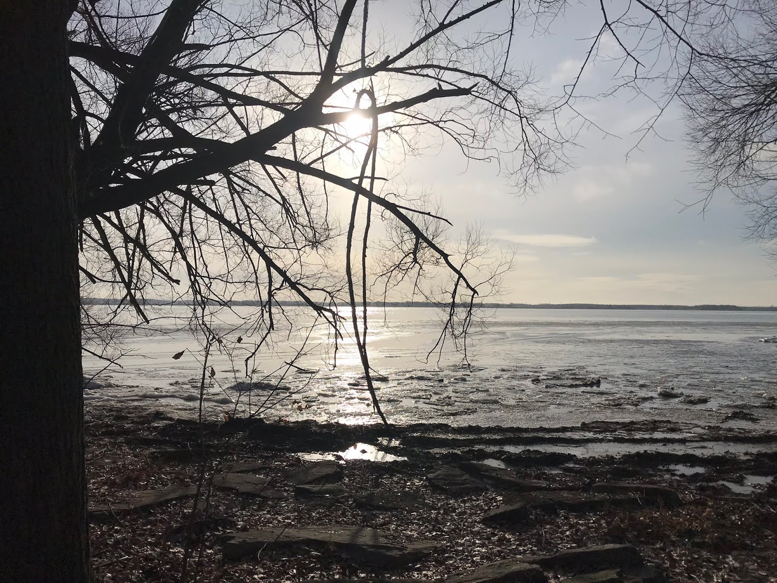
The calm before the storm: A beautiful morning along the shores of the St. Lawrence River at Pointe-du-Moulin on Ile Perrot. (Valley Weather Photo)
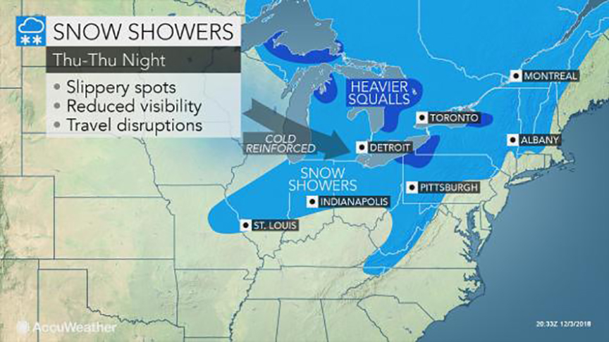
The storm track has become a little more clear this morning, allowing Environment Canada to post a freezing rain warning for Montreal, Cornwall and the Ottawa Valley. Further north and east of the city, precipitation will fall as snow, with a winter storm warning in effect in those locations, including the Laurentians and Quebec City.

Low pressure will move form the Mississippi Valley into the St. Lawrence Valley tonight, and race eastward into Maine on New Year's Day. Expect snow to begin after 10pm this evening, changing to freezing rain in Montreal by midnight, and eventually rain during the wee hours of Tuesday morning. Rain will be the dominant precipitation type south of Montreal, however 5cm of snow is expected here in Montreal, with 5 to 10cm in Ottawa. Additionally, between 5 and 10mm of freezing rain is forecast on top of the snow for Montreal before warmer air arrives and changes the precipitation over to plain rain.

North of Montreal and into Quebec City, 15 to 25cm of snow is forecast. Strong winds will accompany the storm, gusting over 50km/h, producing blowing snow north and east of metro Montreal. Travel will become very poor late this evening and overnight, with snow covered, icy roads and reduced visibility. Conditions will improve rapidly behind the storm on Tuesday, along with colder air changing any leftover precipitation to light snow before ending. Temperatures will warm to 1C (33F) in Montreal by early Tuesday morning, before dropping rapidly behind the system. The low by Wednesday morning will be a chilly -18C (0F).

Have a safe and Happy New Year!

Sunday, December 30, 2018

New Year's Eve snow expected in Montreal and Ottawa

A private contractor puts down a layer of salt in Vaudreuil on Friday evening. A messy mix of 5cm of snow and 12mm of freezing rain, combined with dropping temperatures, have left ice everywhere in metro Montreal. (ValleyWeather Photo)
The weather roller coaster typical of most El Nino winters is well underway in southern Quebec. After a messy mix of rain and freezing rain on Friday in Montreal, the mercury soared up to 6C (43F) during the overnight hours into Saturday. However early Saturday, a potent cold front dropped the temperature down into the minus teens just a quickly. In Montreal, the temperature fell 11 degrees in just a few hours, with the morning low Sunday at -15C (5F). The result is plenty of ice around, especially on secondary roads and parking lots.

High pressure will crest over Ontario and Quebec on Sunday, with just some high cloudiness expected. On Monday, a potent low pressure area and frontal system developing in the US Midwest will approach Montreal, accompanied by a wide swath of precipitation. As with the other storms this month, mild air will return as well. This is a pattern that was established early in December, and shows no real sign of changing soon.

Snow and Freezing Rain
The difference this time is the storm track may be a little to the south of Montreal, allowing for marginally cold air to remain here in the St. Lawrence Valley. We may have enough cold air remaining to keep the precipitation frozen. At this time, expect snow to develop after 8pm Monday night and persist into the New Year, mixing with freezing rain from Montreal south. Eventually all precipitation should change to rain south of Montreal, but remain as snow north and east of the city. Accumulations will range from at least 5cm in Montreal and Ottawa to as much as 15cm in Quebec city and the Laurentians. Regardless of what falls with this system, travel will be impacted across the entire area including southern Quebec, eastern Ontario and northern New England. If you have plans for New Year's Eve, expect snow covered roads and reduced visibility.

The system will move into northern Maine on New Year's Day, with gusty winds, dropping temperatures and flurries forecast for Montreal to start 2019. I will post further updates on the storm as the track becomes clearer later today.

Thursday, December 27, 2018

Sharp warming trend to deliver more freezing rain to Montreal


Freezing Rain Warning in effect for Montreal, Ottawa and the St. Lawrence Valley. If possible, limit travel overnight and early Friday morning. Conditions will improve in Montreal and points south and west early in the morning. Icy travel may persist north and east of Montreal through most of Friday.

A brief 24 hour warming trend is on the way for southern Quebec and the St. Lawrence Valley through Friday. We finally received a little snow on Boxing Day, making it look a touch festive. Unfortunately the 1 to 2cm of fluffy snow also created icy travel and the usual amount of accidents on Montreal highways. Thursday morning was cold, with morning lows of -17C (2F) here on L'Ile Perrot. The cold air will moderate significantly over the next day or so as a strong winter storm moves into the central Great Lakes.

 Montreal will once again be on the warm side of the storm, with a messy mix of precipitation expected to change to rain by mid-morning Friday. After a sunny, cold day today, clouds will increase late this evening. The high today in Montreal will be near -9C (16F), with the temperature rising overnight all the way up to and above the 0C mark by early Friday. Expect a warm, windy high of 5C (41F) on Friday. In terms of precipitation, snow will begin after midnight in Montreal and accumulate 2 to 4cm before changing to freezing rain. We can expect a couple of hours of freezing rain, with less than 5mm of ice accretion expected.

The whole mess should change to rain by noon Friday. The warm air will be short-lived, with a strong cold front crossing the region early Saturday morning. Look for rain to change to light snow Saturday, along with plummeting temperatures. The low Saturday night is expected to be near -16C. Another round of snow is possible for New Years Eve, however accumulations should be on the light side.

Thursday, December 20, 2018

Wet and windy storm to start the winter season

A strong, unseasonably warm storm will move down the St. Lawrence Valley on Friday. Expect freezing rain in Montreal tonight, changing to heavy rain on Friday. (AccuWeather.com)
Freezing Rain Warning in effect for the St. Lawrence and Ottawa Valley.
Heavy Rain Warning posted for eastern and southern Ontario.

The winter solstice occurs at 5:23pm on Friday afternoon, marking the official start to winter. However, you wont be able to tell by the weather, as a warm, wet and windy storm arrives in southern Quebec and Ontario.

Strong low pressure will move north from the Gulf of Mexico into the eastern Great Lakes later today, and eventually down the St. Lawrence Valley. The storm will be packed with moisture, as well as a surge of very mild air. Precipitation will arrive this evening and overnight in the form of freezing rain across our area. Significant amounts of ice are possible, especially north and east of Montreal. Widespread freezing rain warnings have been issued by Environment Canada. Expect 10 to 20mm of ice accretion before the precipitation changes to rain on Friday. I think Montreal will be on the lower end of the freezing rain amount, but enough is expected to make travel dangerous overnight. On Friday, precipitation will transition to plain rain, as the temperature soars to 6C (43F) in Montreal. The rain will be heavy at times, with up to 25mm expected. Some regions may see as much as 50mm of rain. Isolated flooding is possible, especially in locations that have deeper snowpack. In addition to the heavy precipitation, strong winds are expected to develop on Friday, gusting over 50km/h in Montreal and up to 90km/h in northern New England.

As the storm system moves northeast of Montreal on Saturday, colder air will filter back into southern Quebec. Any precipitation will change back to light snow by Saturday afternoon, with temperatures dropping back below freezing. A dusting to several centimetres of snow are possible depending on the timing of the changeover. Sunday through Christmas Day are expected to be partly cloudy with a few flurries and much colder. The colder weather should persist through next week.

Monday, December 17, 2018

White Christmas for Montreal in serious jeopardy

After the mild weather of last weekend in Montreal, there is not much snow left on the ground for the holiday season.
If snow for the Christmas season is your thing, you may be out of luck. A sharp warming trend is underway across southern Quebec, which will be be briefly interrupted through the middle of the work week, before returning in time for the weekend. A cold front is in the process of crossing the St. Lawrence Valley late Monday, accompanied by scattered snow showers. A dusting of snow to perhaps a centimetre or two locally is possible. Temperatures will drop quickly tonight into the minus teens in Montreal, before recovering up to -7C (19F) on Tuesday. High pressure will crest over the region late Tuesday, with another very cold night on tap. On Wednesday, the warming trend will begin, with temperatures heading towards the freezing point and well above by Friday.

Strengthening low pressure is forecast to approach the St. Lawrence Valley on Friday, with rainy and windy weather expected across the region. The rain could be heavy at times, with up to 25mm possible. Needless to say, the rain, along with high temperatures above 5C (41F), will remove any evidence of snow that we currently have in the city. Once the system moves to our east on Saturday, cooler air will filter into southern Quebec, changing any leftover rain to flurries. Only a dusting in anticipated at this time leading up to and including Christmas Day. Colder temperatures will return for the holiday period, but no major storms are on the horizon at this time.

If you thought the number of green Christmases was on the rise in recent years you would be correct. According to Environment Canada data, Montreal had an 85% chance of a white Christmas between 1965 and 1984. During that period, the average amount of snow on the ground on Christmas Day, was 17cm. Since then, the chance of snow on the ground Christmas day has dropped to 70% in Montreal, with an average of only 8cm on the ground. From 1955 to 1985, Montreal recorded six green Christmas Days. From 1986 through 2017, nine green Christmases occurred. Environment Canada defines a white Christmas, as 2cm of more of snow on the ground as of 7am December 25.

As a child of the 70's, I was accustomed to plenty of snowy, cold weather during the holidays. It was a great time to be a kid growing up in Montreal.

Monday, December 10, 2018

Above normal temperatures forecast for Montreal in lead up to Christmas

The North Carolina National Guard patrolling in the central part of the state. Both Virginia and North Carolina were under a a state of emergency this past weekend, as a winter storm produced heavy snow, ice and rain. Powerful winds along the coast generated flooding and widespread power outages. (North Carolina National Guard)
Montreal can expect a cold week, with well below normal temperatures, and perhaps some very light snow late Tuesday. Accumulations are expected to be minimal, with perhaps 2 or 3cm. As we head towards the end of the work week, a major pattern change is expected, with much milder Pacific air beginning to flow across the country. The arctic air will be confined to extreme northern portions of Quebec. This is in contrast to the below normal temperatures we have been experiencing since early November.

Cold weather will persist in Montreal through Friday before mild Pacific air arrives. A major pattern change will lead to above normal temperatures through the Christmas holiday. However it may be marginally cold enough in Montreal, for some snow to fall in the days just before December 25th.
Above normal temperatures are expected to develop on Friday in southern Quebec, with daytime highs going above freezing and persisting throughout the weekend. A storm system developing in the lower Mississippi Valley will move towards the middle Atlantic states and eventually southern New England. Typically we would expect some snow in Montreal from this type of a setup in mid-December. In this instance, with plenty of mld air around, any snow that does fall will be short-lived, changing to rain by late Friday. We can expect showery, mild weather through the weekend, with daytime highs between 2C and 5C (36 to 41F). The normal high this week in Montreal should be -2C (28F).

Even snowplows were struggling to keep up with the record amounts of precipitation across the southern US this weekend. (NCDOT Photo)
Over the weekend, deep low pressure moving well south of our region, delivered record breaking amounts of snow from Texas to the Carolinas. Some locations in North and South Carolina reported over 50cm of snow. Numerous roads were closed, along with thousands of flight delays and cancelations. A state of emergency was declared in North Carolina and Virginia. Power was out to hundreds of thousands of homes and businesses.

White Christmas?
With very little snow on the ground in southern Quebec and metro Montreal, and plenty of mild air and rain in the forecast, a white Christmas this year may be in jeopardy. There are some indications that slightly cooler air will arrive in the week before Christmas, just cold enough to allow some snow to fall. Time will tell, we will certainly know more in the coming days, but a snowstorm on or around December 23rd in not out of the question.

Tuesday, December 04, 2018

Colder weather returns to Montreal for the short-term

A massive late season tornado rolls across central Illinois on Sunday. The storm was one of at least two dozen tornadoes to impact the state. The tornadoes, some as strong as EF-3, produced widespread damage and numerous injuries. Miraculously no fatalities occurred. (TWC Photo)
The strong storm that swept across the central portion of the continent this week, is ushering in much colder air into eastern Canada. The cold air will remain in place for the short-term period, with a reenforcing shot of arctic air arriving Friday. Montreal was on the warmer side of the storm this past weekend, with over 25mm of precipitation falling, ranging from wet snow, to freezing rain to plain rain. Icy roads produced accidents on Sunday morning, especially north of the city. The same storm was responsible for heavy snow along the northwest flank of the system, as well as rare December tornadoes in the warm sector across the US Midwest. The thunderstorm activity even nudged northward into southwest Ontario on Sunday afternoon and evening, with vivid lighting illuminating snow covered fields.

An arctic front will produce flurries and squalls late Thursday, ushering in a very cold airmass for Friday and the weekend. The cold will be short-lived, with milder weather expected to return next week. (AccuWeather.com)
The sun is finally expected to make a brief appearance in southern Quebec on Tuesday, along with some clouds and perhaps a snowflake or two. The weather will be blustery and noticeably cooler, with temperatures reaming in the -4C to -6C (21-24F) range. On Wednesday, clouds will begin to increase once again as a clipper type system arrives from western Canada. These are typically moisture starved storms, and this one will be no different. Some light snow is expected Thursday, with perhaps a few centimetres accumulating. A rather potent arctic front will cross the St. Lawrence Valley late Thursday, accompanied by some robust snow flurries. Behind the front, much colder air will arrive for Friday and the upcoming weekend with lows approaching -18C (0F) for many. The good news is high pressure will dominate, with sunshine expected to accompany the cold weather. No major snowfalls are on the horizon at this time, with the storm track remaining well south of Quebec through the middle Atlantic states.

Looking ahead to the rest of December, it is becoming more likely that a major pattern change will be underway. Above normal temperatures are anticipated through the middle portion of the month, along with below normal precipitation. Depending on which computer model you prefer, a white Christmas for Montreal may be in jeopardy, or salvaged at the last minute during the week leading up to December 25th. Time will tell.

Saturday, December 01, 2018

Icy travel anticipated for Saturday night in Montreal


Freezing Rain Warning in effect for southern Quebec, eastern Ontario and northern New York.

Despite the fact that most of Canada has already experienced snow and cold, December 1st is actually the start of meteorological winter. Right on cue we have some icy weather in our immediate future. A deepening low pressure area will move across the central Great Lakes over the next 24 hours, bringing with it a surge of mild, moist air. The temperature in Montreal will actually go above normal this weekend, for the first time in several weeks. Unfortunately before that happens, we are looking at a few hours of wet snow and freezing rain.

The cloud cover has been very stubborn to erode this week, as is typical in November. Our best bet for seeing any sunshine will come on Saturday, along with high temperatures of 1C (34F). The aforementioned system arrives tonight, with rapidly increasing clouds, followed by precipitation after midnight. Expect freezing rain to begin in Montreal after midnight, possibly starting as a brief period of snow. The freezing rain should transition to rain by 8am Sunday, with 5mm of ice accretion possible in Montreal. The freezing rain will persist northeast of Montreal and in the Ottawa Valley through mid-morning Sunday. The weather will turn showery on Sunday, with a mild high of 4C (40F).

Cold weather returns
The upcoming week will feature mild weather Monday before a sharp cold front returns arctic air to the region. Temperatures will go form well above freezing to well below by Tuesday, along with flurries. The cold weather will persist into next weekend, with several opportunities for light snow.