Wednesday, July 31, 2013

Ottawa EF-0 tornado confirmed

From CBC.ca an EF-0 tornado forms near Orleans, Ontario Monday.
Environment Canada has confirmed that an EF-0 tornado touched down briefly at Pine View Golf Course in the east end Ottawa suburb of Orleans late Monday afternoon. The 5:15pm tornado left about 30 trees snapped like match sticks with winds estimated up to 110 km/h. The storm was part of a series of thunderstorm cells that developed in unstable and humid air on Monday. Several showers and brief thunderstorms also affected Montreal around the lunch hour Monday with brief heavy rain and lightning but thankfully no damage this time. One element of the storms in Montreal I did notice was how much cold air was brought down to the surface during them. The temperature in Montreal fell from 24C to 17C in a matter of minutes around 1pm on Monday.

Tree damage at Pine View Golf in Orleans. (CTV News)
This was the 10th tornado of the season in Ontario. The enhanced Fujita scale (EF scale) is divided into six categories with EF-0 being the weakest and EF-5 being the strongest. On average, 12 tornadoes are verified each year in Ontario during a season that runs from late April until early October. Despite lots of straight line wind damage this summer, only one tornado has been confirmed in Quebec this year.

Wet weather for Montreal & Ontario
Enjoy the sunshine and warm high temperatures near 27C (81F) today because much cooler and wet weather is on the way beginning late Thursday well into this weekend. A cold front will produce showers and thunderstorms on Thursday and then our weather will be influenced by low pressure. A big and slow moving upper air low pressure system will provide much below normal temperatures and the threat for showers and some thunder all weekend as it moves across eastern Ontario and southern Quebec. Highs will only be near 20C (68F) from Friday through Sunday, certainly a taste of Fall to start August.

Monday, July 29, 2013

Showers & thunderstorms to start week

A spectacular end to a beautiful Saturday on L'Ile Perrot.
An upper level low pressure area near the Ontario & Quebec border continues to slowly lift down the St. Lawrence Valley this morning. This system generated thunderstorms Sunday afternoon that produced quite a bit of rainfall depending where you were in the region. Trudeau Airport measured only 11.6mm but I had over 25mm at my home on L'Ile Perrot, the bulk of that falling in a torrential downpour around 4pm.

We will see a similar day today with a little less shower activity, but still the risk of some decent thunderstorms this afternoon. The day starts off with a little sunshine but the air will rapidly become unstable with the showers developing by noon. Skies will clear tonight and we should see a return to sunshine for the middle portion of the week, Temperatures will be below normal today at 22C (72F) but warm to 26C (79F) for Tuesday. It was a cold weekend in places west of this storm system like the the upper Midwest and northwest Ontario, well below normal for July. There was even a frost advisory overnight for northern Minnesota.

Flossie
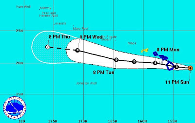
A rare event is occurring today with the arrival of Tropical Storm Flossie on the Hawaiian Islands. Flossie this morning is about 200 miles east of Hilo moving west at 17mph. The center is forecast to cross the Big Island this morning and move across the rest of the region over the next 24 hours. Flossie is expected to produce torrential rains, 50-60 mph winds and very high seas over 20 feet with coastal flooding. Despite the islands being very vulnerable in the middle of the Pacific, Flossie is the first system to affect the island this century, the last coming in September 1992 when Hurricane Iniki pounded the islands.

Friday, July 26, 2013

Weekend weather update for Montreal - 50/50

The weekend will be a split with warm sunshine on Saturday and a period of steady rain and even some thunder on Sunday. This morning temperatures across the region are cool, but better than yesterday, already at 15C (59F) here on L'Ile Perrot. Despite the cold start on Thursday we managed a daytime high of  22C, and it was a near perfect day. This morning some high cirrus is around the region, especially close to the US border. This is in response to an out of season coastal low near Cape Cod and moving north into Atlantic Canada. This will bring heavy rain to portions of the Gaspe and New Brunswick, but remain well east of Montreal.

Skies will be sunny today with warm highs of near 27C (80F) across the St. Lawrence Valley from Montreal to Cornwall. The same forecast holds true for Saturday before clouds increase late in the day. A strong low pressure area and associated fronts will cross Quebec and Ontario Sunday with rain and some thunderstorms lasting into Monday. Amounts could exceed 25mm (1 inch) in some spots.

Thursday, July 25, 2013

From too hot to a September chill in Montreal

A chaotic sky late Tuesday here on L'Ile Perrot as a potent cold front arrives from Ontario at sunset. Thunderstorms can be seen developing off to the west. 
(ValleyWX Photo)

This summer has featured a little bit of everything across southern Quebec, really we have seen it all. The latest season to pay a visit to the summer of 2013 is late fall, and that is what it felt like walking the dog this morning. I had shorts on, as I always do in July, I refuse to put on jeans. We narrowly missed a record low this morning as the temperature dipped to 8.4C (47F) here on L'Ile Perrot, the record 8.3C set in 1976. The airport was a touch milder near 10C (50F). Regions north and south of the city dropped as low as 6C with Saranac Lake in the Adirondacks hitting 0C (33F) in July. This comes after another hot and humid day on Tuesday that saw temperatures pushing 30C once gain in several spots. Thunderstorms along a potent cold front late Tuesday passed well north and south of my location here on L''Ile Perrot.

On Wednesday stubborn low clouds hung around all day in Montreal, and after early morning highs of 22C here in the city, the temperature fell to 15C (59F) and remained there most of the day making it feel like late September. Temperatures are recovering rapidly this morning in the warm July sun as we have hit 13C (55F) already. Looks for dry and mild weather today and Friday with highs of 22C (72F) today, up to 26C (79F) tomorrow. The weekend looks warmer and more humid with showers and thunderstorms from late Saturday into Sunday.

Tropical Storm Dorion has formed in the open waters of the eastern Atlantic. The storm has 60mph winds this morning and is located 700 miles west of the Cape Verde Islands. The storm is moving west northwest at 17mph and will move to lie north of Puerto Rico by Monday.

Tuesday, July 23, 2013

Storm cleanup continues in southern Quebec

From Peter McCabe of the Montreal Gazette, cleaning tree debris in the Ste Rose district of Laval on Monday. Hydro Quebec truck in the background restoring power.
Cleaning up the mess in the aftermath of Friday's severe weather continues this morning across the hard hit lower Laurentians and Laval, north of Montreal. Nearly 15,000 Hydro customers remain with power in Quebec down from nearly one half million during the storm Friday. Municipalities have been removing thousands of fallen trees, especially in Laval where the cleanup may take several weeks according to officials.

I have family in the Montreal suburb of Dorval and they were without power for nearly 48 hours. The bulk of the outages were caused during a three hour period Friday when strong thunderstorms brought an end to the 5 day heatwave. Winds gusted in excess of 100km/h bringing down trees on power lines. Meanwhile lightning struck and tripped many transformers. Hydro Quebec and in Ontario Hydro One and Toronto Hydro have been working around the clock to restore power to its clients. Thankfully it has been a little cooler.
David Asch's photo of his Toyota Camry crushed under a  fallen tree south of St Saveur after Friday's storms.
Today we could see more thunderstorms as a cold front approaches the region from the northwest this afternoon. This morning steady and in some cases heavy rain is falling across New York and Vermont while it remains dry in Montreal and most of the St. Lawrence Valley. I am not expecting severe weather today, just some heavy rain at times. Showers and storms that develop this afternoon will last into the overnight. It will clear out on Wednesday and be much cooler and drier. Highs today in Montreal will be near 27C (80F) but only 21C (70F) Wednesday.

Saturday, July 20, 2013

One fatality as severe weather sweeps Quebec & Ontario

It is still rather warm and humid this morning in Montreal, but an end to the heatwave is just hours away as drier air settles into the region. The temperature will reach 28C today but drop to 13C tonight, which would be the coolest this month. Sunday will be sunny and dry with pleasant highs of 22C (72F).

From Ottawa Valley TVC via Twitter, trailers destroyed by wind in Pembroke, Ontario.
Yesterday was a wild weather day that featured cell after cell of strong thunderstorms sliding along a cold front draped across the St. Lawrence Valley. The front generated strong southwest winds ahead of it that helped push temperatures up to 33C (92F) in the Montreal metro region and as high as 36C (98F) in Burlington, Vermont. It also produced dew points in Montreal that are more common of south Florida reaching nearly 26C (79F) at my home here on L'Ile Perrot. That is the highest I have ever seen in my years watching Montreal weather. All that juiced up the atmosphere and led to the severe storms that swept the region between 2 and 8pm Friday. The activity started in eastern Ontario with places like Pembroke and Kemptville reporting wind damage, power outages and heavy rain. Once arriving in Quebec, the storms toppled trees and power lines cutting hydro to nearly 500,000 homes in the province. Flooding and debris closed several highways including the Laurentian Autoroute at the 640. The storms were deadly with a 21 year old woman being struck and killed by a tree in Boucherville on the south shore. Several others were injured including 8 campers in Prevost in the Laurentians. Regions north of Montreal in Laval and the lower Laurentians were the hardest hit.

Nearly 30mm of rain fell here on L'Ile Perrot between 5 and 7pm with another 8mm in showers this morning. Winds gusted to over 40km/h most of the day here and peaked at 82km/h during the thunderstorm at Trudeau Airport. While many tornado warnings and watches were issued, only funnel clouds were spotted and Environment Canada believes most of the Quebec damage was caused by straight line winds.

Friday, July 19, 2013

Strong Thunderstorms

Tornado watch over for Ottawa. Strong storms continue in southern Quebec with heavy rain. Over 28mm on L'Ile Perrot. Nearly 500,000 without power in Quebec.


- Posted using BlogPress from my iPhone

Tornado Watch for Eastern Ontario

There are already some big thunderstorms developing over northeastern Ontario along a cold front. This afternoon as the front settles into the hot and unstable air mass in eastern Ontario, strong thunderstorms and isolated tornadoes are possible. This is only a watch at this time. It is very hot already with temperatures over 30C in Montreal and humidex values pushing 40C before noon. The dew point at my house on L'Ile Perrot is a tropical 25C (77F) highest this summer. Strong winds are gusting over 60km/h in Montreal as well.

Another hot day Montreal - then big thunderstorms

A Transport Quebec camera captures the slow traffic in thunderstorms in Montreal this morning. It has been a bad traffic week.
The heatwave is into its 6th day here in Montreal with another 31C day on Thursday and 32C forecast today. High heat and humidex advisories are in place across Ontario and into Quebec and now the Champlain Valley of New York. Temperatures today will rise rapidly on strong southwest winds to 32 to 35C (90-95F) region wide with humidex/real feel temperatures over 40C (102F). This will be the last day of this kind of heat for some time, some say until next year! We will have to see about that, in any event a warm front this morning is generating thunderstorms across metro Montreal. As per usual they are staying away from L'Ile Perrot, but they are affecting a large portion of the highway system on the Island of Montreal, slowing down the morning commute. Once these clear the city we are in for a warm and humid day with gusty winds up to 60km/h and hot temperatures.

A strong cold front, the beginning of the end of the heatwave, will begin to produce big thunderstorms this afternoon across eastern Ontario. These will settle into southern Quebec by 5 or 6pm and linger most of the evening. Heavy rain and strong winds are likely. A severe thunderstorm watch is in effect all day until midnight, but most of the strong storms will occur after 4pm for Montreal.

Thursday, July 18, 2013

Big thunderstorms leave thousands in the dark


After a sweltering high of 33C in Montreal on Wednesday, with humidex values near 44C, big thunderstorms swept the region. The storms fired up in eastern Ontario after the lunch hour reaching heights of nearly 50,000 feet into the atmosphere near Bellevile. The storms swept the city at rush hour with torrential rain, hail and strong winds. Montreal Trudeau Airport recorded an 81km/h wind gust at 5pm along with nearly 25mm (1 inch) of rain between 5 and 6pm. The storms did not directly impact L'Ile Perrot, so I measured only 7mm here. Hail was also reported in Laval. The wind and rain knocked out power to more than 60,000 homes in southern Quebec and also flooded several streets in the north end of the city and into Laval.

We will have a brief respite from the severe weather today with another muggy day on tap. Temperatures will be a little cooler than yesterday, but will still likely reach 28 to 30C (83-86F) across the region. A warm front and associated cold front will affect southern Quebec on Friday with another very warm and humid day. Temperatures will reach 32C (90F) with humidex readings well over 40C. A strong cold front will cross the region late in the day Friday bringing an end to the heatwave. Along and ahead of the front a major severe weather outbreak is forecast with heavy thunderstorms for Ontario and Quebec beginning in the afternoon and lasting into the overnight hours. More showers for Saturday and cooler with highs near 25C. It will dry out Sunday with pleasant humidity levels, lots of sunshine and highs near 25C.

Wednesday, July 17, 2013

More heat plus strong thunderstorms for Montreal

HIGH HEAT & HUMIDITY WARNING
SEVERE THUNDERSTORM WATCH
I am not really a big fan of issuing a severe thunderstorm watch so far in advance of the possible activity, but I understand why the Quebec Weather Centre of Environment Canada does it. We have one posted already this morning for western and southern Quebec that will last until 10pm this evening. A watch means conditions are favorable for the development of storms, but they have not formed at this time. A warning would require immediate actions as the storms are on the move. Radar shows nothing this morning in Montreal nor do I expect any activity until much later in the day.

A rather vigorous cold front will be sagging into the warm and humid air that has dominated our weather all week. Highs today should be the warmest of this current heatwave, reaching 32 to 35C (90-95F) across the region. Yesterday eastern Ontario and southern Quebec were in the 31 to 35C range for highs. Montreal just missed the record high on Tuesday by a couple of tenths of a degree at the airport, but easily surpassed it in most other areas of the city. The airport is consistently cooler than readings taken even just a kilometer or two away, it has always been that way. Strong storms will develop later today and persist overnight before ending Thursday. We can expect another warm day Thursday and Friday with more strong storms by mid-day Friday. The weekend looks fair, dry and cooler.

Tuesday, July 16, 2013

Heatwave continues as Beauport hits 38C or 100F


HEAT & HUMIDITY WARNING FOR METRO MONTREAL
I will have to do my homework on this one, but I can't remember the last time any Quebec region topped the (38C) 100F mark. Montreal has come close in recent years, maybe even topped it unofficially in the heart of the city, but at Trudeau Airport where it matters you have to go back to August 1, 1975 for the warmest high in Montreal, and that was 37.6 or 99.7F. Well yesterday one of the normally cooler portions of the province, Quebec City and its suburbs, turned out to be the warmest ion the country. Beuport reached 38C at 4pm or 100F making it the warmest place in Canada. The humidex was a sweltering 45C. Quebec City was 33C and Montreal 33.1C just shy of the record of 33.9. Today we have another shot at a record high with the forecast calling for 32C and the record 32.3C set in 1982.

It will be sunny and very humid once again with temperatures rising rapidly, L'Ile Perrot is already 25C (77F). A weak front will sag south this afternoon with just a slight risk of a shower or thunderstorm. Wednesday will be even warmer with highs pushing 33-35C (90-95F) in most region from Ontario and Quebec south into New England. By Wednesday night and Thursday another front will bring us more widespread thunderstorms. It will remain hot and humid into Saturday before cooler and drier air arrives by Sunday.

This heat is very dangerous, so watch your children and pets as we still hear horror stories of dogs and even children being left in hot cars. The thermometer inside my car yesterday afternoon showed 50C (122F) so even a few minutes in a sealed car is unbearable and life threatening. Drink lots of water and reach for the sunscreen. Be safe everyone.

Monday, July 15, 2013

Ontario & Quebec heatwave

Grapefruit size hail destroyed crops and damaged cars and homes near Weyburn, Saskatchewan on Saturday. This photo was taken on the farm of the Miller family 15km southeast of Weyburn.. More big storms are possible today in and around Regina.
HIGH HEAT & HUMIDITY WARNING: Montreal
High pressure will dominate our weather this week with a very warm and humid southwest flow of air. As a result temperatures will rise into the low to mid 30's with humidex readings from 40 to 42C. This has prompted Environment Canada to issue a heat advisory for most of the southern portion of Ontario and Quebec for today and tomorrow. High temperatures in Montreal will reach 32C (90F). Already this morning at 7am it is a muggy 24C. The same type of weather is forecast for the US east coast from Vermont to the Carolinas. The only break in the heat could be a few isolated thunderstorms in southern Quebec, otherwise the next threat for widespread showers and storms won't come until late Wednesday. Depending on how fast it warms today in Montreal we have an outside shot at the record for July 15, 33.9C set in 1955.

Over the weekend big thunderstorms fired up in southeast Saskatchewan and southwest Manitoba. Tornadoes, heavy rain and grapefruit size hail were observed from Weyburn east towards the Manitoba border. Southern Saskatchewan has another shot at severe weather today including an elevated tornado risk in the south. A tornado watch may be required later today for a portion of the region.

Friday, July 12, 2013

Lower humidity levels today - heatwave starts Saturday

Enjoy the natural air conditioning this morning as temperatures and dew points are much lower in Montreal. I currently have 18C here on L'Ile Perrot, but we were as low as 15C, the coolest this month. More importantly is feels much dryer out there with respectable relative humidity readings. This won't last long so enjoy today with sunshine and 27C. The heat and humidity will build Saturday with highs reaching 30C, but into the 30's for Sunday through Tuesday. It will become sticky and uncomfortable again with the risk of thunderstorms late Tuesday and again Thursday. Humidex readings in metro Montreal will approach 40C early next week, so advisories may be needed. This same type of weather will exist across eastern and southern Ontario as well as northern New England. Overnight lows in Montreal will remain over 20C.

The severe weather late Wednesday afternoon produced Quebec's second tornado of the year. At around 6:15pm an EF-0 storm, the lowest on the scale, occurred northeast of Montreal in Saint-Marc des Carrieres. Other regions in southern Quebec reported wind gusts to 100km/h with some trees down near Drummondville as well as north end Montreal. Hail was observed across the lower Laurentians.

Thursday, July 11, 2013

Dry warm weather finally for Montreal - region

After what has seemed like an endless supply of moisture, a period of warm and most importantly dry weather is upon us. As I stated yesterday morning, Montreal has not had a tremendous amount of rain this month as compared to neighboring communities, but it has been very humid with lots of clouds and mist around. The air quality has been generally poor this month. Yesterday was another very humid day with the temperature hitting nearly 30C. A cold front pushed through  last evening with lots of thunderstorm activity across Ontario and the St. Lawrence Valley, but very little in Montreal and nothing here on L'Ile Perrot. We squeezed about 3 to 5mm of rain out of the showers yesterday, but the bulk of storminess was south and west of the city.

High pressure will now rule the weather into the weekend with sunshine and increasing heat. Highs today will be around 24C (76F) but are expected to rise to nearly 32C (90F) by Sunday and last well into next week. By Sunday the humidity will be building again and along with that the risk of thunderstorms.

Wednesday, July 10, 2013

Strong thunderstorms for Montreal/New England

Photo posted by Dayna Vettese of TWN via Twitter (taken by a friend). This was taken from Toronto Island Airport looking at the outer edges of Monday's storm.
Today may finally be the last in this never ending string of partly cloudy, showery, warm and humid days. While Montreal has not had an impressive amount of rain this month, most areas around us have. This includes the mega storm in Toronto on Monday that finally broke the Hurricane Hazel rain record, and the many, many days of flooding and road washouts across Vermont and New York. I have recorded 31.4mm of rain this July on L'Ile Perrot, just a little over 1 inch. Trudeau Airport has only measured a little over 12mm, the difference being more thunderstorms have affected us here on L'Ile Perrot. This is way below places like Burlington and Plattsburgh, and of course Toronto.

One more front will traverse the region today slowly moving east overnight. Some showers and perhaps a couple of thunderstorms are forecast today for southern Quebec. Some of these once again will be strong, slow movers with the potential for flash flooding. It is muggy already at 23C on our way to 27C.

Skies will try to clear Thursday and it will be noticeably cooler and dryer at 21C. We then head into the best stretch of weather this July with warm sunshine and dry right through Tuesday. Temperatures will start near 25C (77F) but warm to 29C (85F) by Sunday.

Tuesday, July 09, 2013

Record rainfall for Toronto - more rain than Hazel in 1954

A GO train on the Richmond Hill line sits submerged in flood waters from the Don River. Passengers had to be rescued after several hours trapped. (CBC.ca)
More rain fell on Toronto in just a few hours Monday than normally fall in a six week period. As a matter of fact it was the most rain ever. The 126mm (5 inches) at Pearson Airport surpassed the daily record and all time record of 121mm that fell during the infamous Hurricane Hazel in October, 1954. That storm killed upwards of 90 people in the greater Toronto region. All that rain falling in just a few hours was too much for the sewer system or the Don and Humber Rivers to handle sending them over their banks and into streets and homes. Coming right at rush hour, the flooding trapped scores of drivers on area highways as well as 1200 commuters on a GO Train near Richmond Hill. They had to be rescued, two at a time, by a special police marine unit. The water also flooded electrical substations knocking out power to almost 300,000. This morning Hydro One says over 100,000 are still without power, mostly in the west end of the city. Meanwhile Toronto Hydro has 35,000 clients still in the dark. Hundreds of flights were diverted to other airports including Montreal and Ottawa. In Ottawa cots had to be set up in the terminal for people to sleep.

More thunderstorms are expected today from southern Ontario east towards Montreal as the air mass remains very warm and humid. Partly sunny skies and warm highs near 29C are expected in Montreal. The shower and thunderstorm risk will increase into Wednesday.

Monday, July 08, 2013

Major flooding in Toronto


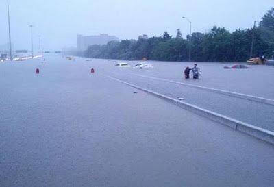
A series of strong thunderstorms have produced major flash flooding in Toronto and across the GTA. Thousands of motorists are stranded on flooded highways and nearly 300,000 hydro customers are without power. In a matter of hours a record 90 to 100mm (4 inches) of rain has fallen across the city with more falling now as another batch of thunderstorms crosses the area. Firefighters are rescuing stranded drivers on flooded highways as well as several hundred stuck on a GO Train. Transit service has all but stopped creating havoc for the evening commute. Heavy rain was reported between 5 and 7pm at Pearson with a record 94mm measured. That usually falls in an average month of July, not 2 hours! Pearson Airport has numerous flight delays and cancellations. Planes are being diverted to Ottawa at this time. Flight delays are spreading to other cities including Montreal.


Another week of humid weather for Montreal

It is a rainy morning at about 17C in Lac Megantic, Quebec as emergency workers and investigators continue to sift through the wreckage left behind from that terrible train accident early Saturday morning. The death toll stands at 5 with 40 missing. My thoughts and prayers go out to all affected by this senseless and needless event.

It was another warm and humid weekend in southern Quebec with highs near 30C on Saturday, but a little cooler 26C on Sunday with clouds and some decent downpours. Around 21mm fell here at my home on L'Ile Perrot. Today, more of the same, warm and humid with the ever present risk of showers or thunderstorms. Flash flooding continues to be a major concern over New York and Vermont where daily downpours have left rivers full and the the ground saturated, watches are in effect. As a matter fact a terrible rash of drownings has occurred in Quebec & New England as a result of people swimming in the rain swollen rivers. Water levels are at record highs after 150 to 300mm of rain fell in June and 90mm in July so far in portions of the Northeast/Quebec. Officials advise you to be extremely careful around any body of water this summer as they are higher and faster than normal.


The tropics are active once again with Tropical Storm Chantal developing late Sunday. The center of Chantal is located about 705 miles (1130 km) east of Barbados with 40 mph winds. The system is moving west at 26 mph with warnings in effect for a portion of the Lesser Antilles. Forecasters believe at this time that Chantal will remain a decent tropical storm as she moves across the Caribbean Sea towards the Bahamas by next weekend. The storm will likely affect portions of Haiti and Cuba with torrential rain by mid week.

Friday, July 05, 2013

Power out Thursday to 500,000 customers in Quebec

FLASH FLOODING: The same old scenario in Burlington, Vermont on Thursday as the wet summer continues. (Photo from the Burlington Free Press)
MORE HOT WEATHER FOR MONTREAL
The weather continues to be in the news this week, from forest fires in northern Quebec and across the southwest US to major flooding in New England and tornadoes in southern Alberta. We have too much rain in the same places and not enough in others. Yesterday was no exception with heavy thunderstorms producing torrential downpours across portions of northern New York and especially northwest Vermont. From 1-3 inches or up to 75mm of rain fell in the storms near Burlington washing out more roads and flooding more homes. It has been the same scenario day after day this summer with flash flood watches or warnings posted daily. I thought yesterday the storms would affect us here in Montreal but they seemed to fizzle out before reaching the city. There was activity north and south of Montreal, but none here on L'Ile Perrot. It did stay very warm and humid with highs near 30C in most locations. The heat was compounded by the fact that power went out across a huge portion of Montreal around 5:15pm. It was out from 30 minutes at a low end to several hours. Some customers, about 15,000, still have no power this morning. That means no A/C as temperatures approach 30C again today in southern Quebec and 38C with the humidity. Hydro-Quebec has blamed the outage on intense heat and smoke from forest fires burning near their James Bay facility tripping three main transmission lines. The fires continue today with the risk of further outages.

The weekend looks the same, more heat, more humidity and more showers and storms, about a 60% chance each day in Montreal. Warm daytime highs from 28-30C (83-86F) with mild nights from 20-22C (68-72F). The humidity will remain elevated with sticky weather forecast well into next week. Keep cool and be safe.

Thursday, July 04, 2013

More stagnant humid air for Ontario & Quebec.

Happy 4th of July to all my American readers. Enjoy the holiday and be safe.

We have a forecast similar to Groundhog Day! I am of course referencing the movie which featured the same day over and over again until Bill Murray got it right. Well apparently we are stuck in the same regime as he was and can't seem to get it right. More clouds, more heat and humidity along with very poor air quality in Montreal. A warm Bermuda high remains anchored off the east coast, while a trough of low pressure lies over the Midwest. In between you have Montreal and most of the east coast. Showers and thunderstorms are likely today in several regions as they have been all this week and last. The difference today is the activity should shift a little further north towards upstate NY and southern Quebec. All week the thunderstorm activity and flash flooding has been across central NY and Vermont. Major flash flooding occurred yesterday in southern Vermont one day after the fierce floods that washed out roads and damaged homes in the Lebanon, New Hampshire area. Storms should fire up after lunch in Montreal with a 40% chance, but I already see some on radar this morning in Ontario.
From WCAX TV 3, some of the washed out roads from Tuesday's thunderstorms in Lebanon, New Hampshire.
The patter will remain in place through the weekend here in Montreal and across eastern Ontario and New England. Showers, thunderstorms, warm and sticky. Daytime highs in Montreal will be in the 28 to 30C range with warm overnight lows of 21C. Here on L'Ile Perrot I already have 24C (76F) at 7:30. With a relative humidity of 88% we already have tropical dew points in the 20's. Stay cool and watch the sky.

Wednesday, July 03, 2013

Record warmth for Alberta - smoke & haze in Montreal

Record heat continues to surge northward into western Canada today as yet another day of hot weather is forecast for southern Alberta into Manitoba. Yesterday temperatures soared into the mid 30's across southern interior BC and Alberta east into southwest Saskatchewan. Sundre, Alberta was 36C and Edmonton a sweltering 34C (94F) shattering the 1964 record of 28.9C. Even Stony Rapids in central Saskatchewan had a record high of 35.4C. Some relief will begin filtering into northern areas with highs only in the upper 20's today in Edmonton.

Meanwhile poor air quality and more flooding was the news across southern Quebec and New England. Forest fires burning in central Quebec have sent a plume of fine particulate matter into the region with poor air quality and smog advisories stretching from Atlantic Canada to Ontario and south into New England. Montreal remains trapped between two weather systems, a Bermuda high off the east coast of the US and a trough and frontal boundary over the Great Lakes and to the south of Montreal. Deep tropical moisture is streaming north along the front with an increase in warmth and humidity forecast right through the end of the week. What this means for the area is much the same, only a little warmer each day. Temperatures were only around 21C on Tuesday here in Montreal, but will warm today to 26C and near 30C by Friday. More showers and storms can be expected each day. The focus for the storms yesterday was across central New York into southern Vermont and New Hampshire. Major flooding was reported around Lebanon. Such has been the case here in the east this summer with a different region hammered by training thunderstorms and flash flooding almost daily. No relief in sight at this time as the pattern holds into early next week.

Tuesday, July 02, 2013

Weather pattern won't budge

More flooding in South Burlington, Vermont after thunderstorms on Saturday. Nearly 10 inches of rain fell on Burlington in June.
The same pattern that is ruining our summer so far, is producing record rainfall in the east and record heat across the west. There is plenty to talk about this morning, lets start with the rainfall for Montreal and across New England. June came to an end with more showers and thunderstorms including additional flooding in places like the Adirondacks of NY, Burlington, Vermont and even Kitchener/Waterloo, Ontario. Record rainfall for June was recorded in Massena/Cornwall with 7.72 inches for the month. Burlington, Vermont had its second wettest on record with nearly 10 inches of rain. Here in Montreal I recorded 170.9mm or nearly 6.75 inches for the month of June here on L'Ile Perrot. July sadly has started off much the same way with clouds and showers. We have just a couple of forest fires burning in Quebec at this time, across central areas of the province where it has been a little drier. That however is enough to send some smoke down to southern Quebec and into the Ottawa Valley this morning with very poor air quality. It will not be a great day with more cloud than sun and perhaps a shower or thunderstorm. Temperatures will be rather cool in Montreal with highs near 22C.

The same weather setup producing the rain in the east is driving record heat across the western US and north into Alberta and BC. On Monday temperatures soared into the mid 30's from interior BC into Alberta. Record highs were established in may locations including Edmonton at 27.4C, and Merritt, BC where it was nearly 37C (100F). More heat and humidity is forecast today across the west. This following the terrible floods in southern Alberta, where cleanup efforts continue in the hot weather.

The heat as extremely dry weather in the southwest US has created a very critical fire situation with many burning out of control. Temperatures have been as hot as 129F in the deserts of Nevada and California. It was such a wildfire in southern Arizona near the Town of Prescott that tragically claimed the lives of 19 firefighters on Sunday evening. The wind driven 13 square mile fire suddenly turned on the elite group of firefighters trapping them near the small town of Yarnell, 85 miles northwest of Phoenix.

A hot and dry June has created critical fire weather in the western US including the Yarnell fire that killed 19 firefighters on Sunday. (AP Photo)