Thursday, June 29, 2023

Smoke set to return to Montreal for 24 hours

Dense smoke over the St. Lawrence River in Dorion last Sunday, June 25. The smoke is set to return Thursday for at least 24 hours across southern Quebec. (ValleyWeather Photo)

Smog and air quality warnings are in effect across our entire region. Smoke from the Quebec wildfires will return across the Ottawa Valley this morning and into southern Quebec by late in the day. This is in response to an upper level low and cold front moving off to the southeast, and a wind shift to the west and southwest.

The smoke will prevail into Friday, before winds shift back to the south, and the heat, humidity and thunderstorms return for the Canada Day holiday weekend.
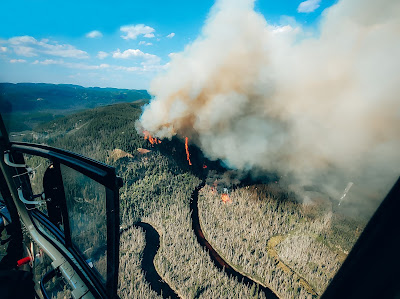
Dense smoke from fires burning in central and western Quebec have been settling across eastern North America and observed as far away as Portugal and France. (SOPFEU)

Beneficial rain is falling in Montreal on Thursday morning. While showers and thunderstorms have been occurring all week long, most areas have been spared heavy rainfall. For example, at my home on Ile Perrot, the first rain of the week is finally falling this morning. I have only measured 46.2mm for the month of June, while parts of Vaudreuil had 60mm in just one hour on Monday. Trudeau Airport for the same time frame has reported 67.8mm. These differences are typical of a warm and humid airmass, where thunderstorms can be hit and miss.

Radar estimates show that as much as 100mm of rain fell in thunderstorms in Vaudreuil-Dorion on Monday, producing flash flooding. However, just across the bridge on Ile Perrot, no rain fell until Thursday morning, and even then only a few millimetres was measured. (Ventusky.com)

The smoke was affecting portions of the Great lakes and Midwest on Wednesday, with very dangerous air quality across the region. Toronto has some of the most polluted air on the planet Wednesday, reporting 15 consecutive hours of smoke. Early Thursday, their air quality has improved, while both Ottawa and Montreal are declining. Current readings show and AQI of 73 in Montreal and an unhealthy 156 in Ottawa.

Widespread smoke and haze is set to return to southern Quebec Thursday afternoon. Another upper level low returns over the weekend with more heat, humidity and thunderstorms. (AccuWeather.com)

The smoke will return for approximately 24 hours before retreating back to the northwest by Saturday.

According to SOPFEU, 110 fires are currently burning in the province, 26 of which are out of control. We are in the worst fire season on record here in Quebec, with close to 1.5 million hectares scorched already. (1 hectare equals 2.5 acres). Resources from New Brunswick, Newfoundland, Yukon, Parks Canada, The Canadian Armed Forces, USA, France, and South Korea have been helping Quebec firefighters battle the fires. The current wet weather across portions of the province is lending a much needed helping hand.

Monday, June 26, 2023

Strong thunderstorms produce flash flooding in Vaudreuil while sparing Montreal

A wall of darks clouds greets an arriving airplane at Trudeau Airport on Monday afternoon. The thunderstorms remained west of the city, producing flash flooding in Vaudreuil-Dorion off the western tip of the island of Montreal.

An intense northward moving line of thunderstorms impacted the Vuadreuil-Dorion region on Monday afternoon, with as much as 60mm of rain falling in under one hour. There are unofficial reports on social media of more than 100mm falling. The torrential rain fell quickly, overwhelming the sewer system and flooding numerous businesses and homes. Among them were Costco and Maxi on Saint-Charles. Parking lots were quickly inundated with water stranding several motorists. The Centre Multisport was also closed for the evening due to flooding. The flooding was isolated in nature, with no rain occurring at my home on Ile Perrot, only 12 kilometres to the southwest.

The storms missed the Montreal region, splitting the city to the east and west in narrow lines. Strong storms also affected portions of the Ottawa Valley, with a potential tornado observed near Thurso, Quebec.

Another area of rainfall with embedded thunderstorms is moving northward along the New York, Vermont border at 10PM and should arrive in the Montreal region later this evening and early overnight.

Any storms will taper off after midnight, with a muggy low of 20C (68F) expected in Montreal. On Tuesday, our weather will continue to be affected by the slow moving upper low pressure as it moves eastward towards New England. Look for very humid conditions, with another round of showers and thunderstorms developing once again during the afternoon hours. There is the risk for more heavy rain and flash flooding. As we witnessed today, not all regions will be affected by the storms.

Sunday, June 25, 2023

Dense smoke settles over Montreal - relief on the way

An unnatural sky in Vaudreuil-Dorion and Ile Perrot as dense smoke covers the region, generated from wildfires in central and northern Quebec. The smoke will lift northwest early Monday morning. (ValleyWeather Photo)

Smog Warning in effect for southern Quebec - Air Quality Advisory in Ontario

Special Weather Statement for strong thunderstorms Monday for Montreal

Sunday has been a very unhealthy day to be outdoors, with widespread smoke form the Quebec wildfires settling over southern Quebec. The Montreal region has had some of the worst air quality on the planet today, with an Air Quality Index (AQI) of 198 as of 7pm. Eastern parts of the city re well over 200. The AQI has been as poor as 297 today. Readings between 150-200 are unhealthy, over 201, very unhealthy. The fine particulate matter can make it difficult to breathe at times, especially for those with respiratory issues. 

Montreal has observed 13 hours and counting of smoke at Trudeau Airport, with the visibility ranging between 2-4 kilometres. Ottawa has reported 16 hours of smoke, with their visibility lowered to between 1-3 kilometres. The smoke has also drifted into portions of northern New York and New England.

The smoke is being generated by 80 wildfires burning in the province on Sunday, many out of control. The fires have scorched nearly 1.3 million hectares of land, over 3 million acres. This is the worst fire season on record for the province. SOPFEU maintains an open air fire ban across the province, with the exceptions of those regions south of the St. Lawrence River. The air quality will begin to improve in Montreal early Monday morning as the wind shifts out of the south due to an approaching upper level low.

The temperature failed to reach the forecast high in Montreal on Sunday, as smoke filtered out the suns warmth over southern Quebec. (Valley Weather Photo)

On Saturday, isolated heavy showers and thunderstorms produced enough rain to create some flooding around 5pm in Montreal. Some parts of the city, including Trudeau Airport, reported up to 25mm (1 inch) of rain in under one hour. It was isolated in nature, with no rain falling here on Ile Perrot.

We have a very wet, warm and humid week ahead, with plenty of showers and slow moving thunderstorms. Between 30 and 50mm of rain is possible locally in the thunderstorm activity on Monday alone, with more rain expected throughout the upcoming week. The storms will develop during the afternoon for Montreal. The high on Monday is expected to be around 25C (77F), with a muggy low near 20C (68F).

Environment Canada image showing the extent of the smoke over southern Quebec and Ontario.


Thursday, June 22, 2023

Warm and humid holiday weekend ahead for Montreal

Warm and humid weather along with frequent showers and thunderstorms are expected for the long holiday weekend in Montreal.

Welcome to summer 2023, arriving right on time at 10:57 AM on Wednesday. 

While we have had some hot days this spring in Montreal, the humidity has been in check for the most part. That will change beginning Friday, as a warm and moist airmass surges northward straight from the Gulf of Mexico into Ontario and southern Quebec.

Along with the humidity will come a daily risk of showers and thunderstorms from late Friday, lasting well into the middle part of next week. While everyday won't be a washout, it will definitely be very humid, with frequent periods of heavier precipitation expected.

As far as temperatures are concerned, Thursday and Friday will be quite warm, with highs close to 30C (86F). Over the holiday weekend, clouds and precipitation will keep temperatures slightly cooler, in the middle 20s, but the aforementioned elevated humidity will increase humidex/real feel readings into the low 30s. The overnight periods will remain very muggy and warm, with lows either side of 20C (68F) in Montreal. Some locations may remain above 21C (70F).

While the threat for severe weather remains relatively low at this time, there will be some stronger storms that produce periods of heavy rainfall, with some potential for flash flooding. The thunderstorm development will need to be monitored, weather warnings may be needed. The greatest risk in Montreal will be each afternoon, Saturday through next Wednesday.

Mother nature has been exceptionally crazy the last few weeks, with everything from forest fires to June snowstorms. Just this week, both record highs and lows were recorded across Newfoundland in the same 24 hour period. Searing heat has set all time record highs across Texas, and that heat surged northward into southern Manitoba on Wednesday, with highs in the upper 30s at some locations. Severe thunderstorms dumped heavy hail across Colorado, while thunderstorms caused significant flooding and damage in southern Manitoba. Environment Canada along with the Northern Tornadoes Project will be investigating damage at Ninette, Killarney, Sidney and Austin, Manitoba to determine if tornadoes occurred. In Fisherton, Manitoba, northwest of Winnipeg, 143.6mm of rain fell during the thunderstorms.

The tropics are becoming active. Above, a NOAA satellite image of tropical storm Bret east of the Leeward Islands on Thursday morning. 

Tropical storm Bret has formed in the Atlantic Basin. Early Thursday morning, Bret was located 205 kilometres east of Barbados, moving west at 22km/h. The storm has winds of 110km/h and was expected to reach hurricane strength on Thursday. Storm warnings have been raised for the Leeward Islands.

Finally as we head into the holiday weekend, keep in mind that there are still 80 fires burning in Quebec. Most of the region north of the St. Lawrence River has a burn ban in effect. Addiotnally the use of fireworks is being restricted for most of the province.

Be weather aware and stay safe.

Friday, June 16, 2023

Unsettled weather for Grand Prix weekend in Montreal

Qualifying for the Canadian Grand Prix was held in the rain in 2022 at Circuit Gilles Villeneuve, and it is looking that way again for this weekends event. Showers are forecast all day Saturday, but dry weather is expected for race day Sunday, with just a chance of a sprinkle. (Stellantis - Alpha Romeo Photo)

Thousands of race fans will be descending on Montreal this weekend for the Canadian Grand Prix F-1 race. Unfortunately the weather does not look great. An upper level low has been influencing the weather most of this week, with numerous showers and thunderstorms across southern Quebec.

The storms were particularly active Thursday afternoon along a trough, producing lots of thunder and lightning, heavy rain and even some small hail. Some much needed rain did fall, with 4mm at Trudeau Airport, and 9mm here on Ile Perrot. There were reports of sporadic power outages and a few tree branches down.

The counterclockwise flow around the system will deliver a few hours of hazy, smoggy weather to Montreal on Friday as more smoke from the Quebec wildfires drifts over the region. A smog warning is in effect for Montreal.

There are numerous activities scheduled, both at Circuit Gilles Villeneuve and in downtown Montreal on Friday, but those attending, will have to dodge more showers and thunderstorms during the afternoon and early evening. Again some of the storms may be on the strong side. The good news is that most of the day will remain dry.

Saturday however will be wet. Another upper level low, the third in a series, will slowly drift from the Great Lakes into central New England while deepening. The result will be showery, breezy and cool weather for Saturday across southern Quebec. As much as 15mm of rain is expected. The damp weather will last all day.

The silver lining is that the system will continue to push east and allow for the showers to taper of Saturday evening. Sunday now looks much better than it did 24 hours ago, with mostly dry conditions, with perhaps a sprinkle of two. Temperatures will be on the cool side all weekend, around 20C (68F) for daytime highs, and in the lower to middle teens for lows.

The heat will return late next week, as we have a pattern change expected to develop. The region will begin to tap into some very warm and humid air that is entrenched over the Gulf states this weekend. We can expect warm and humid weather with scattered thunderstorms starting by mid week and persisting into next weekend. The depth of the heat and humidity and the frequency of thunderstorm activity still needs to be fine tuned.

Friday, June 09, 2023

A break from the smoke across our region...for now

Thick smoke from hundreds of Quebec wildfires envelopes the George Washington Bridge in New York City on Wednesday. The smoke prompted numerous cancelations, flight delays and warnings up and down the east coast from officials asking residents to remain indoors. The air quality readings this week were some of the worst on the planet and in recorded history for many locations from Ontario to Washington. Conditions are improving on Friday for now, but the fire season remains very active across Canada. (AP Photo)

The air quality has improved for many residents of southern Quebec and Ontario on Friday as the smoke has dissipated considerably over the last 24 to 36 hours. Low pressure in the upper atmosphere that has been drifting slowly across New England, is forecast to move east of the region Saturday, finally releasing its grip on our weather. The dreary, smokey and at times wet weather here in Montreal this week, will be replaced by sunshine and warmer temperatures Saturday and Sunday.

However, winds will back to the northwest on Sunday, and more smoke at very high altitudes may drift back into the region. At this time we are not expecting a repeat of this past week, but it will need to be monitored closely.

The smoke was so dense at times, especially across southern Ontario and New York, that air travel was impacted, and numerous outdoor events were cancelled. This included two Major League Baseball games in New York City and Philadelphia.

The smoke is being generated by hundreds of fires burning in Quebec, Ontario and Atlantic Canada. The smoke is being driven counter clockwise around the upper level low and deep into the US. Over 125 fires are currently burning in Quebec, with close to 649,000 hectares burned so far. Nearly 40,000 square kilomteres have burned across Canada this year and it is only June. That makes 2023 the fourth worst season on record to date, likely to become number one within the next week or so.

Relief is arriving from France, Costa Rica, Portugal and the United States. US President Biden has promised 600 firefighters and several aircraft to assist with the Canadian response.

Another low pressure system arriving late Sunday and Monday promises more beneficial rainfall for Ontario and Quebec, but also more lightning. Southerly winds accompanying this low pressure will result in a warmer, more humid airmass than the current system. Along with the showers will be frequent thunderstorms in the humid air. Lightning from last Thursdays thunderstorms in Quebec is believed to be the leading cause of many of the major fires currently burning in the province.

The rain this week has been helpful, but more is needed. Since June 1st, 7.2mm of rain has fallen at Trudeau Airport. The normal for the entire month of June is 87mm.

Wednesday, June 07, 2023

Some relief from wildfire smoke in Montreal

Haze and smoke lie across the western horizon in Montreal on Monday afternoon. Poor air quality has resulted in widespread weather warnings from Quebec and Ontario southward along the US Eastern Seaboard. Some relief is on the horizon for metro Montreal, but eastern Ontario, including Cornwall and Ottawa, will continue to bear the brunt of some of the worst air quality in the world.

Smog warning in effect for metro Montreal

The air is still thick  with smoke across many parts of western Quebec and southern Ontario, stretching as far south as the Carolinas on Wednesday morning, but some relief is in sight. A stubborn upper level low pressure system retrograding over New England, has brought some light rain and cooler temperatures to many parts of the province. While amounts have been very light, less than 2mm here in Montreal, any rainfall is welcome. The cooler temperatures are helping as well.

The circulation around the low has driven the worst of the smoke into eastern Ontario and western New York state. That region has measured some of the worst air quality in the world over the last 24 hours, with widespread visibilities under a couple of kilometres along with high numbers of fine particulate matter. Levels have been very high in eastern Ontario especially, with very unhealthy to hazardous levels reported.

The smoke and haze caused many outdoor activities to be cancelled in the Montreal region and across western Quebec into Ontario on Tuesday.

The smoke is being generated by nearly 150 active wildfires burning across the province that have consumed nearly 500,000 hectares (1.2 million acres). For may, this is the worst fire season already in Canada, and it certainly has produced some of the poorest air quality at many locations since record keeping began.

While conditions will briefly improve here in Montreal, many other locations will still be dealing with the smoke and extremely dry weather.

Widespread air quality advisories remain in effect on Wednesday. The low pressure in question helping to propel the smokey air southward, will only drift eastward very slowly, persisting into Friday. By the weekend, high pressure will attempt to clear skies out, and we may see a break from the smoke.

We need rain. The showers expected this week are forecast to produce 5-10 mm of rain in the Montreal region, but much more is needed to break the dry almost drought-like conditions across the southern and western portions of the province.

Tuesday, June 06, 2023

Poor air quality as hundreds of fires burn across Quebec

An unnatural view of the sun on Tuesday morning over Montreal. Smoke from over 150 wildfires burning in Quebec, is resulting in poor air quality as far west as Toronto and as far south as New York City. (Valley Weather Photo)

Smog Warning posted for southern Quebec, with Air Quality Advisories in effect for eastern Ontario, New England and New York.

The record warm and dry weather of the last week or so has taken a toll on the Quebec forest fire season. The province is now reporting over 153 fires, many burning out of control. The amount of hectares covered has exploded to 223,877, well-above the ten year average for the date. There have been 434 fires since the start of the year in Quebec. Nearly 10,000 residents have been forced from their homes, especially in the hard-hit Abitibi, Cote-Nord and Saquenay regions.

While strong low pressure did bring rain to eastern parts of the province, the western portion remains bone dry. The low pressure produced gusty north and northeast winds that have driven dense smoke into Ontario, southern Quebec and as far south as New York City. Very poor air quality is producing spectacular sky conditions but also contributing to increase in repository and health issues.

SOPFEU map of the more than 150 fires currently burning across Quebec. Each red icon represents a fire burning out of control. (SOPFEU)

What we need now is rain. To date, Montreal has had only 0.2mm recorded at Trudeau Airport for June. Last month we measured only half the normal rainfall. A soaking rain would help firefighters gain some ground in the province. Nearly 480 firefighters are on the ground, helped by at least 200 Canadian Armed Forces. Resources are being requested from other parts of Canada, the US and as far away as France and Costa Rica.

Thousands have been evacuated in the province as one of the worst fire seasons on record continues. (Radio Canada)

The weather system we had last Thursday, produced very little rainfall, with plenty of lightning and gusty winds, the perfect ingredients to start and spread wildfires quickly. Currently a province wide burn ban remains in effect.

The balance of the week is forecast to be cooler, with scattered showers at times and perhaps a ruble of thunder. While we are not expected a huge quantities of precipitation, any amount at this time would help.

With hundreds of wildfires burning across Canada, authorities fear this may be the worst fire season on record for the country.

Friday, June 02, 2023

More record heat for Montreal - but cooler weather on the way

A provincial water bomber battles a blaze burning out of control near Chapais, Quebec. Resources have been spread thin across the province, as more than 100 fires are burning at this time. The good news is cooler weather is on the way, with some rain expected as well. (SOPFEU)

Thursday was smoking hot in Montreal, about as hot as we get at any time during the year, The high at Trudeau Airport was 34.3C (94F) smashing the previous record of 29.3C (85F) set in 2011. The heat was even more impressive downtown at the McGill/McTavish location, where a 131 year old temperature record fell, with a high of 34.8C (95F), surpassing the 1892 record of  30.7C (87F). No matter how you look at it, or where you were in southern Quebec, it was hot!

The humidity remained low for the day, with very little moisture available as a frontal boundary slipped south across the Laurentians into Montreal by 5pm. That set the stage for a series of dry, windy Prairie-like thunderstorms around the supper hour. The storms generated lightning and strong wind gusts in the 70km/h range, but sparse rainfall. There was more dust being blown around in most locations than anything else. The front did produce a sudden drop in temperatures as the thunderstorms collapsed bringing cooler air from the upper atmosphere. Here on Ile Perrot, the temperature dropped from 35C (95F) to 27C (81F) in less than 10 minutes.

The humidity levels have risen overnight in Montreal, and we have a better chance of stronger storms Friday afternoon, along with some heavy rainfall, as a backdoor cold front arrives from the northeast. The storms may be briefly severe, with heavy rain and lightning the main threat. Before the storms, we have another record high expected today of 31C (88F). The record to beat was 30C set in 1970.

We need the rain desperately as the fire situation has grown exponentially over the last week. Over 100 active fires are burning across the Province of Quebec at the moment, eight considered out of control. According to SOPFEU, the hectares burned as exploded up to 15,152 in the last week. A burn ban remains in effect across the province, as well as into Ontario and Atlantic Canada. Be very vigilant with any source of fire or heat outdoors, it does not take much to ignite the dry vegetation at this time. One fire is threatening the central Quebec community of Chapais where some evacuations have been ordered.

The heat and smoke from the fires triggered a massive power outage in Quebec Thursday afternoon, with over 250,000 Hydro-Quebec customers in the dark and heat, including 88,000 in the Montreal region.

There is some good news as cooler weather in the way for the weekend. The high Saturday will be a more seasonable 22C (72F), along with gusty northeast winds up to 50km/h. We also have more rain and much cooler weather forecast for next week, which will certainly bring some much needed relief to the fire situation across eastern Canada.