As Canadians we talk about the weather relentlessly, I just talk about it a little more! I hope to provide useful information to my family, friends and all those who simply enjoy talking about the weather. My primary region of concern is the St. Lawrence Valley of Quebec, Ontario, and New York, as well as our neighbouring regions. This Blog is dedicated to my late father for inspiring my interest in weather, and to my "all weather" pup Bella.
Monday, May 17, 2010
Saturday, May 15, 2010
Hello from Maryland
Last night a gusty potent little thunderstorm went through Montreal at midnight with lots of thunder and vivid lightning and about 7mm of rain. This morning winds were gusty and it was quite chilly when I left at 5am. Today while driving in sunshine and increasingly warmer temperatures it was about 17C in Montreal. By the way on a non-weather rant, I can't believe how much fun it is to drive in New Jersey. It is probably the only place where a Quebec driver going 75mph can be passed by everyone other car. Crazy!
Anyway I hope to post some pictures over the next week or so, once I get a USB cord for the digital. In the meantime be good and enjoy the increasing sunshine and warmth in Montreal as I head towards the May long weekend.
Thursday, May 13, 2010
Cool May weather continues
Anyway back to the weather. It has been a rather traquil week with scattered frost across the area. I had a little on the roof of my car this morning on Ile Perrot southwest of downtown Montreal. The sunshine will warm us up to about 17C today. A week frontal boundary will provide us with some showers Friday and early Saturday before a sunny and cool day Sunday. It appears the warmer weather will try to make a run at the region early next week. We may see a 22 or 25C day by Wednesday.
Monday, May 10, 2010
Frost Warning
Sunday, May 09, 2010
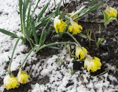
Snow on Mother's Day

Friday, May 07, 2010
Weekend Update
Wednesday, May 05, 2010
May Blizzard
As Montreal basked in summer warmth with thunderstorms, Alberta was being hit by the second spring blizzard in as many weeks. Nearly 16cm of snow surprised Edmonton yesterday with fierce winds. The storm was expected to affect mostly the southern portion of the province, but a heavy band of wet snow set up over the city. Amounts ranged from 7cm in Spruce Grove to 16cm on the east side of town. The strong winds created havoc on area highways with reduced visibility. Winds were gusting over 60km/h in Edmonton and as high as 113km/h in Onefor. Snow continues today in the southeast part of the province and into southwest Saskatchewan and northern Montana. The storm also delayed flights in Calgary and Edmonton and cut power to over 15,000 hydro customers.
Meanwhile eastern Ontario and Montreal had temperatures over 20C yesterday with thunderstorms. Some storms in Ontario became severe with gusty winds over 80km/h and small hail. Today will be sunny and 22C with more showers by weeks end. The Mother's Day weekend, sorry to say, looks rainy, windy and cold as the western system moves east.
Tuesday, May 04, 2010
More snow for Calgary
On the east side of the storm more warm and muggy air will feed thunderstorms across the Midwest. In our region another cold front is producing showers and thunderstorms today with the biggest threat being heavy downpours and perhaps small hail. A gusty storm went through the Montreal region at around 7am this morning with strong winds.
Monday, May 03, 2010
Tropical air mass
It is hard to believe we had a humidex reading of 30C and and overnight low of 19C in Montreal during the same week we had a snowstorm, but hey here we are. Yesterday was very muggy across the eastern two thirds of North America as a steady stream of humid air poured northward. Montreal reached 26C but it was much warmer in Vermont and New York with temperatures approaching 30C. The warmest place in the US over the weekend was Norfolk, VA at 36C. The same areas that had 2 feet of snow on Tuesday were over 80F yesterday. This morning numerous showers and thunderstorms are around the St. Lawrence Valley as a cold front approaches from the west. The front will move the humid air off to the south and east and clearing skies will ensue with winds increasing out of the northwest from 30-50km/h.
Over the weekend this same air mass produced unprecedented flooding across the southern sates including Tennessee where nearly 8 inches of rain produced severe flooding in Nashville closing Interstates and washing away cars, homes and people. The death toll is at 15 from the weekend storms including several deaths in Arkansas from tornadoes and sever thunderstorms. The heavy storms are along the Gulf Coast today from Louisiana to Florida and Georgia. The storms along the Gulf Coast are hampering the US Coast Guard in clean up efforts (see National Geographic photo above) in one of the worst oil spills in US history. Millions of litres of oil are spreading north from an uncapped British Petro (BP) oil well in the Gulf of Mexico towards the Louisiana, Mississippi, Alabama and Florida coasts. Already marine life is washing up along the shores and fishing has been suspended for at least the next 10 days. Rough seas and storms over the weekend made it difficult to set up booms and skim the oil off the surface of the Gulf.
Friday, April 30, 2010
Weekend Update
Only in Canada could you go from 20C weather on Monday, a snowstorm on Tuesday, 20C weather by Friday and thunderstorms and 24C by Sunday. What a weather week. Power was slowly being restored across Vermont, NY and southern Quebec after the record setting snowstorm that saw nearly 2 feet of snow fall across some regions. Montreal had 7cm which melted by the end of the day on Wednesday. Another strong low pressure area is moving across Montana and the northern plains and into Ontario. A warm front will generate some showers this evening in the region followed by a partly sunny and warm Saturday and Sunday. The trialling cold front will sweep the Montreal area late Sunday with showers and thunderstorms. Severe weather is expected again this weekend in the plains and southern states. Meanwhile this storm delivered a powerful snow event to Alberta with heavy snow and winds gusting to over 100km/h in the southern half of the province. As much as 70cm fell in the foothills with about 10cm in Calgary. Numerous roads were closed and flights delayed.

Awesome win by the Habs, I through in this Aislin cartoon from Thursday's Montreal Gazette into the mix. They begin the next round against Pittsburgh tonight after defeating Washington in 7 games.

Wednesday, April 28, 2010
Storm totals
For the record, the latest storm in Montreal was 21.8cm on May 10, 1963 with the latest measurable snow May 17, 1959 when 1.8cm was observed.
Skies should clear later today with the mercury reaching 11C and melting the snow here in the city. It may take a day or so elsewhere. Drive with care today especially south and east of the city.
Tuesday, April 27, 2010
Late season snowstorm
SNOW
Despite our warm spring snow is falling this morning in Montreal.Heavy snowfall warnings are in effect this morning for the regions just east and south of Montreal including the Richelieu Valley, Townships, Beauce and Quebec City area. Wet snow has been falling across the area this morning and even in Montreal. Accumulations could be in the order of 10-20cm at elevations above 500 feet and just a slushy coating here in the city and on the valley floor. Winds have been gusting out of the northeast at 30 to 50km/h with a gust to 58km/h at Dorval overnight. Low pressure off the eastern seaboard will slowly move northeast today with cold winds and wrap around moisture producing wet snow right into the overnight period. Yesterday Montreal reached a high of 17C but we have dropped all the way down to just above freezing at 1C this morning. Light snow is also falling across Eastern Ontario including Ottawa. Precipitation should taper off this afternoon in Ontario.
South of Montreal Winter Weather Advisories are posted for the Champlain Valley in Vermont and NY, and St. Lawrence Valley of New York for 5-15cm of snow. Winter storm warnings are in effect for the Adirondacks and Green Mountains for up to 25cm. Places affected by poor travel today will include Plattsburgh, Malone, the Tri-Lakes, Stowe, Jay Peak, Newport and north towards Sherbrooke and Quebec City and the south shore of Montreal. Travel will be slippery with reduced visibilities on area highways, especially tonight. The combination of wind and wet snow may bring down power lines or tree limbs especially south and east of Montreal.
Monday, April 26, 2010
Snow in late April
Mississippi hit hard
Vehicles were swept off Interstate 55 in Mississippi from a tornado that cut a swath 1/2 mile wide and nearly 100 miles long across the state on Saturday. Below is a radar close up from Accu-Weather of the storm crossing I-55 in Mississippi.Nearly 17 counties in the state of Mississippi have been declared disaster areas after a series of severe storms and tornadoes swept that state over the weekend. The storms were part of a strong spring low pressure area that spread rain and severe weather from the plains, Colorado and Texas across the lower Midwest and into the southeast, Mississippi and Alabama. The death toll is at 12 from the weekend including 10 in Mississippi. Hard hit Yazoo City, Miss, was flattened by an estimated F-4 tornado with winds in excess of 160mph. Over 600 buildings were destroyed including churches and brick buildings. Trees wee uprooted and flag poles bent over at 45 degree angles from the fierce winds. Cars and trucks were swept off Interstate 55 south of Vicksburg. The storms are affecting south Florida today from the Everglades east towards Miami.

SPRING SNOW
The same system is bringing showers to much of the middle Atlantic and Northeast. The low pressure is currently over Ohio and will move off the coast tonight while an associated upper level low spins into the Champlain Valley. The combination of these two systems will produce a cold northeast wind across the region tonight. As temperatures lower rain will develop and slowly mix with and change to wet snow over the higher elevations of the Townships and Vermont/New York. A winter storm watch has been posted for these regions with 10-30cm of heavy wet snow possible above 1000 feet. The NWS is estimating the heaviest snow to fall Tuesday night around Jay Peak, Vermont. Here in Montreal and the St. Lawrence Valley, a cold northeast wind will gust over 50km/h with showers changing to scattered wet flurries. No accumulation is expected in the Valleys. Snow fell over the weekend from Calgary east into southern Saskatchewan and North Dakota. This morning a snow/freezing rain mix is occurring in southeast Saskatchewan with warnings in place.
Friday, April 23, 2010
Weekend Update
From severestudios.com, a tornado near Goodnight, Texas yesterday.A potent spring storm continues to sweep across the plains into the southern states today. This system was responsible for nearly 3 dozen tornadoes yesterday, primarily in Kansas, Colorado and Texas. The storms were impressive with heavy rain, hail and strong winds. While damage was reported, no serious injuries or fatalities were. The photo above is from a tornado near Goodnight in the Texas panhandle and was pulled from a dramatic video by storm chasers from SevereStudios.com. The entire video can be viewed HERE.
This system was expected to give us some rain by Sunday, but it now appears that high pressure will dominate the region with most of the activity passing well south of us into New York and Vermont. Overnight temperatures fell to the freezing point this morning with scattered frost. I had to scrape the car window on Ile Perrot to the southwest of Montreal this morning. As mentioned high pressure will give us clear cool nights and sunny warm days right into early next week. Some clouds and perhaps a stray shower may work into the border region with New York late Sunday.
The plains storm will continue to produce severe weather from Oklahoma and Texas east into Mississippi and Alabama today. More tornadoes are possible for the next 24-36 hours with this low and cold front. On the back side of the storm heavy snow, from 1 to 2 feet is forecast for the Colorado Rockies.
Thursday, April 22, 2010
Happy Earth Day
St. Lawrence Valley for Sunday into early next week.EARTH DAY
Celebrate Earth Day today by doing some simple things to help the planet. Don't idle the car at the drive through, get out and go inside for your coffee. Shut the water off while you shave or brush your teeth, take shorter showers. Turn lights off when you leave a room and power down the computer at night. All simple things that if done on large numbers, will preserve our wonderful country and planet for future generations. Try it today and make it a habit.
Click here for more information: Earth Day!
Wednesday, April 21, 2010
More showers today
I am hoping to take my new lawnmower out for a test drive Saturday. It looks like an ideal day for any outdoor chores or activities. Temperatures will be slightly cooler but still above normal for April. Sunday looks showery at this time.
Record Highs
It's Alberta's turn for record high temperatures this week. Strong high pressure is pushing daytime highs into the mid-twenties as far north as the Yukon & NWT. At least a dozen record high temperatures were set yesterday including 26C at Grand Prairie and 24C at Edmonton. In the NWT, it was 20C in Yellowknife, 25C in Hay River and 12C for a record high all the way north in Inuvik.
Tuesday, April 20, 2010
A few thunderstorms
Skies are sunny this morning across eastern Ontario and Quebec with mild temperatures. It will be dry most of the day, but a weak cold front will combine with a slightly unstable air mass and daytime heating to generate more showers and isolated thunderstorms by late in the day. Skies will clear out this evening before the same scenario occurs on Wednesday with more showers and thunderstorms. Conditions should improve on Thursday.
Volcano Update:
Regarding the volcanic eruption on Iceland, some flights are beginning to take off in southern Europe, but it may be another day or so before Britain and northern Europe can begin scheduling flights. New eruptions today are threatening to expand the ash cloud once again. So far the predominately westerly winds have kept the ash from affecting eastern Canada. The cost of this eruption is being estimated in the hundreds of millions of dollars a day with over 10,000 flights being canceled worldwide, including the transportation of perishable goods.
Monday, April 19, 2010
Volcanic ash moving west
Ash rising from this Iceland volcano continues to ground air travel in Europe causing a ripple effect around the globe. The economic impact will be significant. BBC PhotoThe erupting volcano under the Eyjafjallajoekull Glacier in Iceland continues to send ash thousands of kilometres across the Atlantic into northern Europe. The ash has grounded air travel since last Wednesday forcing cancellation of over 4000 flights and stranding thousands of passengers. There are indications that the ash is now moving westward towards Canadian air space and Newfoundland. Low pressure in the north Atlantic is creating a northeast wind in Newfoundland carrying the ash towards that province. The exact impact is not clear at this time, however Environment Canada is closely monitoring the situation. Several flights to St. John's have already been cancelled. A special statement has been issued by Environment Canada HERE.
Friday, April 16, 2010
Weekend Weather
**This is an awesome video of a meteor shooting across the Midwestern sky last night. Check it out here at ACCUWEATHER.COM
Tuesday, April 13, 2010
Prairie spring storm
Monday, April 12, 2010
Sunny week
Friday, April 09, 2010
Weekend Update
Low pressure moving across western Saskatchewan is producing an area of steady snow today with 10-20cm forecast. The big story with this system is a trailing cold front that has a history of wind damage from southern BC across Alberta. Winds will howl out of the west in Saskatchewan at speeds of up to 100km/h. Wind warnings are in place across most of the southern and central parts of the province and into northern Montana. Blowing snow in the north and west and blowing dust in the south will make travel difficult at times with near blizzard conditions possible along the Yellowhead from the Battlefords to Lloydminster.
Yesterday 14cm of snow fell at Kirkland Lake in northern Ontario with 10cm in the Soo east to Sudbury.
Thursday, April 08, 2010
Thunderstorms & SNOW
Dueling Seasons
Despite the heavy snow this winter, record heat is producing a serious fire threat across portions of the northeast including New Jersey - shown above yesterday, where temperatures were in the upper 80's.There is lots to talk about this morning, and I will try to maintain some order, rather than my usual routine of being all over the place. Lets start with yesterday and that line of thunderstorms that raced through Montreal around 8:45am. They dumped about 15mm of rain in just 15 minutes across portions of the island and south onto the south shore. It also produced reports of 1cm hail. Temperatures yesterday remained chilly all day in Montreal and along the US border as we remained in the cool sector. Just south of us more record heat was sending temperatures soaring into the 90's. Boston had a high of 91F, the earliest 90 degree day ever. They usually do not surpass 90 until June 5 on average. A cross section of the temperatures across the region from north to south at 3pm yesterday looked like this, Montreal 13C, Burlington 15C, Montpelier 25C, Springfield, VT 29C, Boston 32C and New York City 32C. I think you can see where the warm front was lying.
Today is very different in the region. A cold northeast wind has dropped temperatures down to 3C here in Montreal with drizzle. We can expect it to remain chilly for the next 36 hours with steady rain at times and the risk of thunderstorms as well. Winds will be gusty from the northeast at 30-50km/h. The air has chilled sufficiently enough in the western Ottawa Valley for freezing rain this morning. On the back side if our rainmaker, low pressure moving across the Ohio Valley, snow is falling in Wisconsin, northern Michigan and northwest Ontario. From 10-15cm of wet snow is forecast. Showers and thunderstorms will continue across our region into Friday before it slowly clears out with a risk of some flurries. The weekend looks sunny and seasonable.
Wednesday, April 07, 2010
First thunderstorm
9am: A severe thunderstorm watch as been posted for Montreal until 10:30am. More thunderstorms are developing in the moist unstable air mass and producing very heavy rain, lightning and small hail. One passing over the West Island at this hour is dumping torrential rain with low visibility and very dark skies. These showers will move across the island over the next hour.
The first thunderstorm of this young 2010 season rattled across Ile Perrot and the western tip of Montreal island at around 3am this morning. Thunderstorms developed along a warm front that is stuck here in the St. Lawrence Valley. It will slowly begin to sag back south again into upstate New York leaving us on the cool and unstable side of it. A northeast breeze will hold temperatures around 12C today in Montreal while they will reach 20C in Toronto and Burlington and 30C in New York City. Low clouds and fog along with drizzle will also occur here in Montreal. In the last hour more thunderstorms have fired up in the Ottawa Valley and are rapidly moving east so we may have another rumble or two of thunder. The storm overnight dropped about 15mm of rain into my gauge at home.
Moving forward we can expect low pressure from the Midwest to move into our region Thursday with another 10-20mm of rain followed by much cooler weather and the risk of a flurrie or two Friday and early Saturday. Skies will then clear out for a sunny and seasonable weekend.
This morning temperatures are already approaching the mid 70's (22 to 24C) across the Ohio Valley and mid Atlantic, while in Denver and across Colorado, Wyoming and the Dakotas, light snow is falling with temperatures below freezing.
Tuesday, April 06, 2010
Battle of the seasons
Lake Champlain looked inviting in the 80 degree weather this past Saturday.However the National Weather Service is warning people to stay away from area rivers and lakes that are running high and fast, and most importantly are only about 36F (2C) at this time of year. Hypothermia can occur in seconds. The same rule applies on both sides of the border.
ValleyWX Pic
That may have been one of the best long weekends ever. Bright sunshine and record high temperatures in the upper 70's (20's C) on Friday and Saturday, were followed by decent weather with very mild temperatures for Sunday and Monday. While no records were broke yesterday the temperatures remained well above normal. Record warmth is being felt all along the eastern seaboard with temperatures in the 70's and 80's or about 20 to 30 degrees above normal. The normal high in Montreal is about 43F (8C) for April 6. Despite clouds and showers from and advancing warm front today, we will still reach the 55 to 60F (13 to 15C) range. Rain will develop along that front today in the St. Lawrence Valley, and taper off after midnight tonight. Warmer temperatures with some breaks are possible on Wednesday in the warm sector. A sharp gradient will be in place from north to south with temperatures in the upper 70's in southern New England to near 60 (16C) in Montreal tomorrow. A cooler pattern with more rain and even some flurries is possible by Friday.
Meanwhile out west, winter continues with heavy snow falling across the Rockies and northern plains. In between, heavy thunderstorms are forecast in the Midwest, Ohio Valley, and eventually the Great Lakes and northeast by late tomorrow. We may even hear a rumble of thunder in Montreal for the first time this season.
Friday, April 02, 2010
Summer warmth
Meanwhile the cool Atlantic is keeping Boston at 11C (52F) while most other locations in New England are in the 75-80F range with the exception of the immediate Lake Champlain shore line and as mentioned the immediate New England coast.
It appears we will skip a season, at least for the next two days. Strong high pressure will dominate the weather along the Atlantic coast and New England into southern Quebec and Ontario. The warm sunshine and strong southerly flow will push the mercury to summer readings of about 20 degrees above normal to record highs of 25C in Montreal and 23 to 27C in most regions away from the rivers or lakes. The cooler bodies of water will keep temperatures down in places like Kingston. The record high in Montreal for today was 16C set in 2009 and for tomorrow's date it is 21C set in 1981. If all goes as planned we should shatter those records. Temperatures are responding slowly this morning as areas of fog burn off. But they are coming up nicely to our west and south with readings already near the 17C mark along the US/Ontario borders.
Wednesday, March 31, 2010
Historic New England flooding
The month of March has produced some of the heaviest rainfall in recent memory across New England and the middle Atlantic states. Yesterday was no different as nearly 7 inches of rain fell in Rhode Island and Massachusetts producing record breaking - life threatening floods. Flooding of this magnitude has not been seen since the early 1950's when back to back hurricanes, Connie and Donna flooded the region. The Pawtuxet River is cresting at nearly 9 feet over flood stage and has forced closure of Interstate 95 near Warwick. Major flooding has forced thousands out of their homes with rivers continuing to rise in Rhode Island, Massachusetts and Connecticut. The map below shows how much rain fell during the most recent storms. The heaviest rain remained just to our south along the US border. Some regions have had almost 2 feet or rain in March.WARM MARCH
Montreal received about 25mm of rain over the last week to bring our monthly total to only 59.2mm (2.2 inches). That amount fell on only 6 days of the month. We normally have precipitation on 13 days during March. The incredible stats are our daily maximum temperatures and snowfall. The average maximum was 7.7C compared to a normal of 2.2C. The mean average was a warm 3.3 compared to the normal of -2.3C. We recorded only 1.4cm of snow officially at Dorval, or less than one inch. Unbelievable for a "winter" month. We are looking at potential record highs on both Friday and Saturday with temperatures reaching 25C.
Tuesday, March 30, 2010
More rain - then summer warmth
Flooding continues to be a major issue from New Hampshire across Massachusetts and southern Connecticut and into new jersey and New York. parts of New jersey are experiencing the worst flooding in over 25 years. In Massachusetts the Governor has declared a state of emergency, and the National Guard has been called out.
After the rain tapers off late Wednesday, skies will clear out under strong high pressure, and record setting warmth and sunshine will move into the east for the Easter long weekend. Look for sunshine and temperatures approaching June values from 24 to 27C.
Monday, March 29, 2010
Rainy start...warm finish
The good news is that once the rain moves out by Wednesday, we can expect a large ridge of high pressure to build in from the central US. A bubble of warm, summer like air will arrive just in time for the long Easter weekend. I expect sunshine Friday and Saturday with temperatures over 20C.
Friday, March 26, 2010
Earth Hour
Earth Hour occurs tomorrow night at 8:30pm local time. You are asked to shut down all lights for one hour to help save the earth and our environment. Earth Hour started in 2007 in Sydney, Australia when 2.2 million homes and businesses turned their lights off for one hour to make their stand against climate change. One year later Earth Hour had become a global sustainability movement with more than 50 million people across 35 countries participating. Global landmarks such as the, Sydney Harbour Bridge, The Cross on Mt. Royal here in Montreal, The CN Tower in Toronto, The Golden Gate Bridge in San Francisco, and Rome’s Colosseum, all stood in darkness, as symbols of hope for a cause that grows more urgent by the hour. Visit HERE for more information.
Thursday, March 25, 2010
Very Cold Friday
Our roller coaster weather week continues along, with the greatest dip poised for tonight in Montreal and Ottawa and across the region. Yesterday Montreal reached 11C after a morning start with sub-zero temperatures and snow cover. The afternoon sun was warm and temperatures rebounded to well above normal. Today will be sunny and very warm once again on increasing southwest winds in advance of an arctic boundary. That front will cross the St. Lawrence Valley by 8pm this evening with showers and some snow squalls along it and a dramatic drop in temperatures. In a month that has been above normal almost everyday along with no sub-zero highs (very rare for March), tonight and tomorrow will feel frigid. The front will drop temperatures from today's high of plus 12C down to -10 to -13C overnight, a swing of almost 25 degrees. Along with the cold Arctic air will be strong winds from the southwest, backing to the northwest tonight and gusting to 50km/h producing noticeable wind chills. Any precipitation will freeze on area roads so keep this in mind while traveling. Friday will be sunny, but very cold, and perhaps our fist below freezing high for the month at -2C.
A quick wrap up of Tuesday's storm, it produced about 16mm of rain in Montreal with the heaviest rainfall southeast of the city. Lennoxville had 33mm and parts of Vermont over 50mm. Heavy snow fell north of Quebec City with Le Massif in the Charlevoix region recording 47cm. Winds gusted to 63km/h in Montreal, and 94km/h on Ile d'Orleans near Quebec City.
Tuesday, March 23, 2010
Storm Update
Heavy rain
Issued by The National Weather Service
Burlington, VT
11:24 am EDT, Tue., Mar. 23, 2010
THE FLOOD WARNING CONTINUES FOR THE EAST BRANCH AUSABLE RIVER AT AUSABLE FORKS. * UNTIL THIS EVENING... OR UNTIL THE WARNING IS CANCELLED. * AT 10:15 AM TUESDAY THE STAGE WAS 6.5 FEET. * FLOOD STAGE IS 7.0 FEET. * MINOR FLOODING IS FORECAST. * FORECAST... RISE ABOVE FLOOD STAGE BY THIS AFTERNOON AND CONTINUE TO RISE TO NEAR 7.1 FEET IN THE AFTERNOON. THE RIVER WILL FALL BELOW FLOOD STAGE BY THIS EVENING. * IMPACT... AT 7.0 FEET... MINOR FLOODING CAN OCCUR IN KEENE. WATER BEGINS TO OVERFLOW ONTO HULLS FALLS ROAD... ROUTE 73... AND ROUTE 9N NEAR MARCY FIELD. HIGH WATER WILL IMPACT INTERESTS AT ALICE FALLS NEAR KEESEVILLE.
Low pressure this morning over Pennsylvania will move northeast to near Boston by late today. Radar at 8am (shown above) was showing heavy rain over the Montreal region, it has been falling since about 4am. Winds are gusting out of the northeast to 63km/h at Montreal, and 65km/h at Quebec City. While Montreal is reporting rain at 1C, the northern edge of the precipitation is falling as freezing rain and snow. Mirabel is 0C with freezing rain and Quebec City is -1C with snow. The cold rain, freezing rain and snow will continue all day with 20-40mm of total precipitation expected. Heavy snow is falling north of Quebec City into the Saguenay and Charlevoix regions. Roads are very poor in those areas as well as north of Montreal, where several schools have been closed for the day. Traffic is slow in metro Montreal due to water accumulation on area roadways and reduced visibility in heavy rain.Weather Warnings are in effect for heavy rain, freezing rain and snow in most regions outside of metro Montreal including Eastern Ontario and the Ottawa Valley. Flood watches have been posted for New York and Vermont. Winds will remain strong today gusting over 60km/h. All precipitation will end overnight tonight as a period of wet snow with 5 to 10cm (2-4 inches) expected in many parts of southern Quebec and eastern Ontario, with a little less in the city.
Monday, March 22, 2010
Warnings Posted
Winter returns
Low pressure over the Ohio Valley is forecast to move into southern New England by Tuesday morning. A warm front will lift northward to just south of the St. Lawrence Valley overnight. In advance of this storm heavy rain will develop across New England and move north into Ontario and Quebec. The rain may begin as a period of freezing rain in the St. Lawrence Valley and Montreal as northeast winds keep the temperatures at or just above 0C. On Tuesday strong northeast winds and heavy precipitation are forecast. This system will bring 25mm (1 inch) or so of precipitation falling either as rain or a mix here in Montreal. There is the possibility that some warnings may be required, especially for the regions north or Montreal and the Ottawa Valley.
This same system dumped heavy wet snow across the southern plains over the weekend and is producing heavy rains across Pennsylvania and Ohio. Over 50mm (2 inches) of rain is forecast for the water logged region of southern New England and metro New York where flood watches have been raised. More warnings may be required later today and I will post them as they are issued. Check back this afternoon for an update.
Sunday, March 21, 2010
First Day of Spring?
Friday, March 19, 2010
Weekend Update
The weekend looks variable as several fronts affect southern Quebec. It will remain mild, but clouds will be on the increase along with showers by Sunday. A steady rain may develop into Monday before it turns cooler with a snowflake or two. No major storms are on the horizon, but it will turn much cooler into next week as temperatures settle back to normal values for late March.
Spring arrives at 1:32pm EDT on Saturday.
Wednesday, March 17, 2010
Record Warmth
Record high temperatures were scattered across the region yesterday including 13.1C in Montreal and 15C in Ottawa, both well above the normal high of 2C for mid-March. It was 14.4C in Kemptville, ON and even 20C in Calgary for the warm spot in the country. High pressure will dominate our weather again today with the early spring sun pushing the mercury to 15C. A weak cold front tonight will bring a few clouds and maybe a sprinkle. It will be sunny and a little cooler Thursday before low pressure heads for the St. Lawrence Valley this weekend with clouds and showers. At this time it still appears that the temperature will come back to normal next week with the chance of some snow or rain. The warm weather has resulted in a rapid melting of all the snow pack. That combined with the weekend rains is producing fast, cold and high running water on area rivers, streams and lakes. Be very careful on or near any ice or water for the time being.
Tuesday, March 16, 2010
New England Flooding
Rapid snow melt and heavy rain produced flooding across New England. Below: heavy surf damaged this home on Plum Island, Mass. (Boston.com photos)
Flooding spread across metro New York and New Jersey into Connecticut and Massachusetts yesterday and continues this morning. Numerous rivers are at record flood stage including the Merrimack River along the New Hampshire border with Massachusetts. Heavy rain and rapid snow melt have combined to produce what many had feared after this winters heavy snow, a rapid melt. Thankfully the storm that caused over 5 inches of rain and wind damage is moving into the Atlantic Ocean this morning. Skies are clearing out in all regions, and it will be sunny and warm for several days to help dry things out.
The next chance for rain in Montreal will come later this week. While it remains mild, and today is the official day in Quebec that you can remove snow tires, my advice would be to wait. Indications are there will be a major shift in the weather pattern the last week of March that could produce some snow in southern Quebec and Ontario. Stay Tuned! For the short term enjoy the sunshine and 14C weather today and Wednesday.
Monday, March 15, 2010
Worst storm since 1985
Damage in Scarsdale, NY. (NY Times Photo)The storm that swept the metro New York region this weekend was the worst since hurricane Gloria in 1985. Winds of over 70mph tore down thousands of trees, crushing cars, homes and in some cases people. The storm left almost a half a million customers without power. This morning over 300,000 are still in the dark in metro New York, including Long Island, southwest Connecticut and New Jersey. In addition to the wind, coastal flooding and heavy rain has left many regions under water. Nearly 5 inches of rain fell with rivers still rising. Some evacuations will be needed especially in Massachusetts.
Montreal remained on the western edge of the storm with 50km/h winds (30mph) and about 18mm of rain or about 3/4 inch. In Montreal the sun is shinning this morning and it will be a fair and mild work week. Most of our snow is now gone with the exception of some dirty piles in parking lots.
Sunday, March 14, 2010
Storm Update
As of 8am EDT this morning, a strong storm continues to spin off the Delaware coast. Abundant moisture and strong winds are feeding inland across New York, eastern Ontario and southern Quebec. The temperature in Montreal has been falling since late afternoon Saturday, and we are now at 1C with a rain/snow mix and northeast winds at 50km/h. The rain and cold temperatures with gusty winds will continue all day in the St. Lawrence Valley. Further south snow is accumulating across the highest elevations of the Green Mountains, so a winter storm warning has been posted for 4 to 7 inches of wet snow in that region. Coastal areas continue to see flooding and pounding waves. Flooding is also occurring across southern New England and western New York. Travel today with great care as roads are wet and in some cases snow is falling.
Of note the death toll is at 5 from falling trees in the New York metro region. Power remains out to hundreds of thousands across the tri-state region. Highways are closed from flooding and trees are down everywhere, too many to count.
Saturday, March 13, 2010
Another strong Nor'Easter
Friday, March 12, 2010
Weekend Update
It was a poor decision to play with the clock on the weekends and take away an hour from us. Why not do it in the middle of the workday! On that note, remember to do just that task before going to bed Saturday night, spring forward one hour. The weekend will be decent in southern Quebec and eastern Ontario as we remain on the northern edge of yet another east coast storm, the same scenario that has played out all season. Saturday will be partly cloudy and mild, while Sunday will be much cooler with showers. This time it is a warmer storm system with heavy rain (not snow) and thunderstorms expected from the Ohio Valley into the middle Atlantic and northeast US. Winds and clouds will begin to increase in the St. Lawrence Valley late Saturday and into Sunday. With the storm passing to our south and east, winds in the valley will be out of the northeast, this should result in a very cool, raw day for the big St. Patrick's Day Parade in Montreal. While I think the heavy rain will stay to our south, any precipitation at plus 2C with a northeast wind will make it feel uncomfortable outside. It will warm again next week under clearing skies.
It has been a very dry start to March, just like February. To date in Montreal we have had 0.0mm of precipitation. You have to go back to February 27th for the last precipitation. Normally we should have 73.6mm for the month of March. February recovered during the last 10 days or so ending the month with 49mm including 47.8cm of snow. Normally we should have 61.5mm and 43cm of snow for February. So ironically we had more snow than normal last month, go figure, it sure did not show.
Thursday, March 11, 2010
Mild weather contiues
Tuesday, March 09, 2010
Oklahoma Tornado
Post #900 (Hard to believe, thanks for reading!)A true sign of the seasons yesterday as severe thunderstorm and tornado activity was reported across the southern plains of the US. Low pressure, which will become our weekend weather maker, moved from California across the southern plains producing the heavy storms and spawning a tornado near Hammon, Oklahoma. No injuries were reported, but damage was significant and 5 homes were destroyed. Tornado activity typically increases across this region from March into April and May before it shifts northward. On average Oklahoma records 4 March tornadoes, last year there was only one.
Meanwhile Montreal was sunny and a warm 10C yesterday as most of our snow continued to dissolve away. The forecast is for sunny and mild weather into Friday morning before the southern plains storm moves into the region with rain for the weekend.
Monday, March 08, 2010
Fair, Dry & Mild
Friday, March 05, 2010
Weekend Update
Thursday, March 04, 2010
The Blizzard of 1971

Classic images of the Blizzard of 1971 in Montreal. My most vivid weather memories were of the small sidewalk plows like the one in the photo above and the scores of snowmobiles.As we prepare to enjoy our first round of spring weather, my thoughts are on March 4, 1971, a day that I remember so well. I was only 5 years old when the largest blizzard in Montreal history slammed the city. I spent the day literally in the windowsill of our duplex on LaSalle Boulevard in Verdun watching the events unfold. We were right on the St. Lawrence River and the wind howled down that street. Little did I know that day would spark a lifelong passion in weather. It remains to this day the largest snowstorm to strike this city and parts of the province. The 24 hour snow totals were impressive with 47cm in Montreal and over 60cm in other parts of Quebec and Ontario. Drifts were over 6 feet high. That was just a small part of the story. This storm was an Atlantic nor'easter with the ferocity of a hurricane. The barometric pressure during the height of the storm dropped to 972mb or that of a Category 2 hurricane and winds gusted to over 120km/h in many parts of the St. Lawrence Valley including 110km/h at then Dorval Airport. I spent the day in the window watching snowmobiles go back and forth in the zero visibility for hours rescuing motorists and delivering people to area hospitals. Roads were closed including the 401 and 20 and power was out to thousands of Hydro customers.
I found some photos from a news report by Radio Canada and posted them on this entry.
Here is another link to find out much more on the Blizzard of 1971.
Wednesday, March 03, 2010
Another near miss
From AccuWeather.com, a dog frolics in the snow across the deep south yesterday as they continue to have our winter!Low pressure will move from Cape Hatteras, North Carolina to well east of Long Island, NY tonight. Snow has spread from the deep south through the middle Atlantic and into coastal New England today with up to 10cm of wet snow expected. Winds will be strong out of the northeast up to 80km/h. This weather will move into Maine and coastal New Brunswick and Nova Scotia tonight. Meanwhile strong high pressure will build into the St. Lawrence Valley with spring weather for Montreal. The only fly in the forecast will be gusty northeast winds from that Atlantic Ocean storm. They will blow out of the northeast in the order of 20 to 40km/h today making it feel cool and capping the temperature at 2 or 3C. Abundant sunshine will last into the weekend with warm temperatures, well above freezing during the day and just below at night, reaching 8C by Saturday. Yesterday it was colder in parts of Georgia and Alabama than it was in Montreal. Snow fell in Atlanta, closing roads and schools as the bizzaro winter of 2009/10 rolls along.
Tuesday, March 02, 2010
Early Spring Weather
Enjoy the mild weather but remember, that March and April hold the distinction of having the biggest snowstorms in Montreal and southern Quebec including the record breaking March 4, 1971 storm and the March 13, 1993 super storm as well as on April 4, 1975. You get the idea I could go on there are so many more examples. I guess what I am saying is don't put away the shovel just yet.
Monday, March 01, 2010
In like a lamb
Well it appears lamb-like across our region today. Low pressure once again along the east coast will provide steady snow and rain from New York City and Boston into Maine and the Maratimes. It will spare our area with the exception of a few showers or flurries and some gusty northwest winds. A few centimetres may accumulate near the US border and into Vermont. Skies will clear out very slowly on Tuesday and high pressure will take over and dominate the weather for the balance of the week with sunny skies and very mild temperatures. Overnight lows will be in the -5 to -8C range with daytime highs in the warm March sun soaring to between 4 and 6C on the plus side. Ice and snow will begin to melt quickly so keep that in mind when venturing near area waterways. Also make sure that drains and catch basins are free of snow and ice so that the winter can flow freely away!