Wednesday, July 14, 2010

Rocky Mountain July SNOW

Photo from Kent Kasey of The Birmingham News, Alabama (ai.com). Apparently his golf game was interrupted. You have to love Alberta weather!

While we have been sweltering in high heat and humidity a snowstorm affected portions of the highest elevations of the Rockies from Alberta into northwestern Montana earlier this week. I was looking at the numbers for Jasper, Alberta and they are very impressive. A slow moving unseasonably strong storm moved across the Prairies with heavy rain in Alberta and thunderstorms in Saskatchewan. This is all part of what has been a very stormy year in western Canada. Jasper was 32C (90F) on Friday, July 9th. Just 2 days later, as the rain moved in along a cold front, the temperature had plummeted to 1.6C (34F) and the heavy rain changed to heavy wet snow. Jasper recorded about 57mm of precipitation with at least half of that falling as snow (by some accounts as much as 20cm). The same storm brought heavy rain to the other parts of Alberta with 100mm at Red Deer and 67.6mm at Edmonton.

Roller coaster week

The weather will improve today as the clean up continues at the St. Catherine Locks along the St. Lawrence Seaway on Montreal's South Shore. The CSL ship the Richelieu dumped about 75 tonnes of oil into the seaway on Monday forcing closure to all ship traffic. According to the St. Lawrence Seaway Management Corporation, the seaway should reopen by tomorrow. (Montreal Gazette photo)

The one constant this week will be the muggy and warm air. Otherwise showers, clouds and sun will mix for the balance of the week as a series of frontal boundaries affects eastern Ontario and Quebec. yesterday most of the the thunderstorm action remained well south and west of Montreal passing through the Seaway and south into New York State. The main feature of these storms was the very heavy rain and sporadic flash flooding. Over 40mm of rain fell in many locations from Cornwall and Massena south and east. Despite the ominous forecast Montreal had just a few millimetres of light showers late in the afternoon with a rumble or two of thunder. The storms that passed south of Montreal late Monday night produced an 80km/h wind gust at the airport in Dorval and snapped some hydro poles and tree branches. The threat for thunderstorms today is minimal, but hey you never know this summer.

Tuesday, July 13, 2010

Heavy rain possible today

SEVERE THUNDERSTORM WATCH: Metro Montreal 10AM-9PM

A frontal boundary slowly moving across Ontario and Quebec today will be the trigger for some juicy thunderstorms. Yesterday Montreal reached 29.5C which was just enough to trigger some big storms especially north of the city across the Ottawa Valley and Laurentians. Late in the day a strong cell moved north from New York state across the south shore, just clipping the island. Heavy bursts of rain and strong winds with vivid lightning accompanied the storm.

The same air mass remains in place this morning with elevated dew points and humidity and the chance of some clearing, the atmosphere will become very unstable. Already this morning with the limited clearing to our southwest, daytime heating is allowing for thunderstorms to erupt. Temperatures will reach 26 to 28C today. Environment Canada has posted a severe thunderstorm watch for southwest Quebec for today effective 10am until 9pm. Typically when a watch is issued this early it is because of the threat of flooding rains from the thunderstorms. Such was the case last Friday. The possibility exists today for 25-75mm (1-3") of rain due to thunderstorm activity. No warnings are in effect at this point. Check the live updates to the right for any warnings that may be posted today.

Showers will continue into Wednesday before clearing skies Thursday and a return to showers and thunderstorms once again for Friday. It will remain warm and humid through the week.

Monday, July 12, 2010

Another warm week ahead

It will be another warm day across Ontario and southern Quebec with high temperatures reaching into the lows 30's. While this week will be muggy and warm, the dangerous heat of last week will not be matched. Dewpoints will allow the humidex reading to reach about 35C, nearly 10 degrees cooler than last week. A frontal boundary late in the day today will set up the chance of thunderstorms into the overnight period. The unstable air will stick around on Tuesday with the likelihood of more showers and thunderstorms. The balance of the week will be warm and humid with showers or thunderstorms again by Friday. In others words a very typical July week in Montreal.

Sunday, July 11, 2010

Less humid...still warm

Despite the passage of a cold front on Friday, it remains warm and humid across southern Quebec. Yesterday the mercury topped out at 28C (83F) while down about 10 degrees from Friday, it remained muggy, and scattered thunderstorms developed late in the afternoon and moves east of the city. This morning it is warm again - already up to 27C in Montreal with a humidex of 33C. There remains a very slight risk of an isolated shower today or perhaps a rumble of thunder. The upcoming week will feature more muggy and warm air. This week will not be nearly as hot as the record breaking heatwave of last week, but it will be uncomfortable. Temperatures will be near 30C and into the low thirties by Friday with humidity values increasing and the humidex reaching 40C by Friday as well.

**I missed one record high last week that was on Tuesday, July 6 when we reached a temperature of 34C at the airport just beating the record set in 1993 at 33.5C. Of note, the overnight lows during last weeks heatwave were actually warmer than the lows during the famous 1975 heatwave in this city. The 1975 heatwave is responsible for the warmest temperature ever recorded in Montreal at the airport, 37.8C (100.4F). Last week our lows from Monday to Friday were in the 24 to 25C range for some of the warmest overnight lows this city has ever recorded. Downtown, on most nights, it remained near 27C or 80F.

Friday, July 09, 2010

Severe weather threat continues

End of a Heatwave
The thunderstorms that swept the island of Montreal at 1pm today produced flooding in many regions including along the Trans Canada near Fairview in Pointe Claire (above & below). The temperature dropped from 30C to 23C during the storm. (Photos T. Cobrin)

Heavy flooding rains swept across the island of Montreal around 1pm today. It had already reached 30C just prior to the storms and the atmosphere was saturated from the week long heatwave. The storms dumped 40mm of rain on the city in less than 1 hour. The result was flooded highways and basements. Strong winds and lightning cut power to about 14,000 homes across the city. A severe thunderstorm watch remains in effect for the region until midnight as the cold front is still to our west and the atmosphere remains unstable. A second and even third round of storms may be possible this evening. Flash flood watches are also posted across New York State and Vermont.

Flooding possible today

Dog Days of Summer

This photo was sent to me yesterday, I am not sure of the source,
but boy does he have the right idea!

12:30pm Update: Warnings for heavy rain have been extended across all of eastern Ontario including the National Capital District. Heavy, slow moving thunderstorms are also developing ahead of the cold front in the tropical air over our region. Radar is showing several storms southwest of Montreal moving towards the city. The bulk of the heavy steady rain is still west of Ottawa. It is hot again in Montreal, 30C at noon with a humidex of 40C.

8:36 Update:
Radar is showing thunderstorms with heavy rain stretching from the Ottawa Valley to Lake Ontario moving very slowly east towards east central Ontario. The first indications that these storms will be soakers is in the form of Heavy Rain Warnings now posted from Renfrew to Peterborough in Ontario for 40-60mm of rain or more. I imagine these will be the first of many warnings today.

As the heatwave moves into day 5, relief is on the way in the form of a very slow moving cold front. The front has been crawling across Ontario towards western Quebec and the St. Lawrence Valley. Concern is increasing for flooding, and at this unusual hour of the morning and well in advance of the front arriving in southern Quebec, Environment Canada has posted a severe thunderstorm watch for metro Montreal and the surrounding region. The storms today will be slow moving in nature and dripping wet with moisture. The potential exists for 50mm or more of rain in a very short period of time. The concern is so great that flash flood watches have been posted for all of New York State and Vermont. The storms will develop in the tropical air by noon and persist into this evening. The threat for wind damage or hail is not that great, the main threat will be flooding. Historically heatwaves don't just fade away they end with an event. Keep in mind the Decarie flood of July 14, 1987.

Speaking of heat Thursday was another impressive day. Many locations including Ottawa, Kemptville, St Anicet, Gatineau and up into the lower Laurentians reached or exceeded 35C. At 3pm yesterday afternoon St. Anicet on the shores of the St. Lawrence River was 35C with a humidex of 46C. Burlington, Vermont won the heat award yesterday, reaching 36C and tying a long standing record. Montreal reached 34C beating the record of 33C from 2008.

I will post more information today on the flood potential as the threat develops.

Thursday, July 08, 2010

Record breaking heat

The numbers are impressive from this current heatwave along the eastern seaboard and into southern Quebec, Ontario and now the Maratimes. Montreal reached 33.7C yesterday beating the old record of 32C set in 1982. We are forecasting a high of 34C today which will edge out the previous record of 33C set in 2008. Another fact of this heatwave has been the overnight temperatures. At 3am this morning, Montreal was one of the warmest cities in eastern Canada and the entire Northeast at 26C (79F). Our low was a record breaking 25C as we continue to establish all time records for highest overnight lows. The humidex is another interesting fact. The combination of heat and humidity has pushed the humidex value over 42C for three consecutive days. If it does the same today and tomorrow it will be the first time in the history of this city that this has happened. As a result of this, the city has opened cooling centres across the Island of Montreal and extended outdoor pool hours. You can obtain all the information at ville.montreal.qc.ca or by calling 3-1-1. Please check on all your neighbours, friends and family especially seniors.

High heat and smog advisories remain posted region wide again today. Temperatures will soar into the 31-36C range. Yesterday afternoon in Ile Perrot and St. Lazarre at around 6pm we had a heavy tropical shower. The storm dumped a quick 10-15mm or so of rain on the area and knocked the temperature down a few degrees. The result was sauna like conditions for the balance of the night. We can expect the same today with a risk of showers and thunderstorms. The heatwave will break late Friday as a cold front sweeps into the region. Temperatures will cool into the upper 20's with much lower humidity.

Other high temperatures yesterday included 35C (95F) at St Anicet/Lancaster, 35C in Ottawa, 34C (94F) at Kemptville and 33C (92F) in Toronto. A late afternoon sea breeze cooled Boston to only 28C (83F) while New York reached 37C (100F) before cooling into the upper 70's last night.

Wednesday, July 07, 2010

Montreal 94F - NYC 103F

A young girl has the right idea in Philadelphia yesterday. AP Photo

The heatwave is into day 4 with relief in our future, but not until Friday and specifically Saturday. Yesterday was just plain hot. What is most unusual about this heatwave is how warm it is staying at night. Montreal reached 33.6C (94F) yesterday, but had dropped only to 29C (85F) by midnight last night. Our overnight low was a sweltering 24C (76F) the normal low is 15C (59F) - we are currently back up to 26C (79F) as of 8am. Other portions of the east coast continued to suffer in intense heat yesterday. Boston reached 99F, while Central Park in New York was 103F and Baltimore was 105F. Newark, NJ reached 102F but they reached 100F before 11am. Montreal should easily surpass today's record high set in 1982 at 32C.

Power grids up and down the northeast coast and into Ontario are being stretched to their limits. Yesterday several regions reported power failures and more can be expected today. Such is not the case in power rich Quebec. According to Hydro Quebec, consumption on Monday was 22,000 megawatts compared to a normal July day of about 18,000. According to the power authority, while it is high, it is nothing compared to the winter when we can reach daily consumption of 37,000 megawatts. We are ok, and apparently like heat more than cold.

The City of Montreal will announce today that cooling centres will finally be opened. I will post that information once I receive it. I encourage you anywhere within this heatwave area to check on neighbors and friends and especially the elderly to make certain they are keeping cool.

Heat Advisories remain posted region wide today with high temperatures forecast from 32 to 36C or about 90-97F. Humidity is on the rise as well with dew points in the 22C range producing humidex values over 40C. Limit outdoor activities and seek shelter if you feel faint. Drink lots of water, this from our resident intern Dr. Obvious!

Relief should come be the weekend with showers and thunderstorms forecast and a much cooler high of 27C by Saturday.

Tuesday, July 06, 2010

Heatwave continues

We are well into our third and likely the hottest day so far in this current heatwave. The warmest temperature ever recorded in Montreal was 37.6C back on August 1, 1975, we may see that fall with this current heatwave. (The warmest temperature recorded in Canada was 45C at Yellowgrass, Saskatchewan on July 5, 1937. Oddly enough a good friend of mine moved to Yellowgrass in 1994 and I have visited there often.) Montreal at 8am was an incredible 27C with a humidex of 36C. The heat index is already knocking on the door of 100F and it is only 8am. Overnight numbers were impressive, as it never went below 25C at the airport, one of the warmest nights this city has ever recorded. I managed 24C overnight at my place on Ile Perrot, that was after yesterdays high of 34.6C at my home, but officially 32C at the airport. Other area temperatures were 34C at Toronto, 34C at Ottawa and 36C (97F) at Plattsburgh, NY.

Needless to say Urgence Sante has been busy here in Montreal. They are on a second level emergency plan with all hands on deck and six extra ambulances on the road. Yesterday they had over 450 calls by mid-afternoon. Many were heat related with heat stroke and exhaustion the main calls. Conditions will not improve before the weekend, with hazy, very hot and increasingly humid weather forecast. Air quality will also deteriorate increasing the risk of respiratory problems. The warmest is yet to come with forecast highs of 35C by Thursday. We may see some relief by Saturday.

A high heat warning is in effect for southern Quebec and eastern Ontario along with a smog advisory. Meanwhile south of the border warnings for heat and poor air quality have been extended into Vermont and all of New York. All locations will see highs between 95-100F and heat indexes slightly above 100F.

Monday, July 05, 2010

High Heat and Humidity

Lake Champlain looked inviting yesterday near Plattsburgh Beach in upstate New York. The Green Mountains are in the background. It will be 90 - 95F in Plattsburgh today.
ValleyWX Pic


High heat and humidity advisories are in effect across a wide area of southern Quebec today and into the middle portion of this week. High pressure over the eastern portion of the continent is surging a tropical air mass of hot and humid air up the entire eastern seaboard. This morning the mercury is already at 24C in downtown Montreal and 26C at both Toronto and NYC. The temperature will climb to 33C today with humidex reading in the low 40's. Across the east coast highs will be close to the 100F mark in New York and Washington and mid 90's in Boston. The heat will be accompanied by smog and poor air quality. Advisories are in place across all of western and northern New York as well as southern and eastern Ontario and southern Quebec. Overnight lows will only cool slightly to the mid 20's. There is no break in site at least until the end of the week. Scattered thunderstorms will prevail most afternoons and evenings. According to the NWS in Burlington, this week has the possibility of being a true heatwave, the first since 2003. A heatwave is 90F (32C) or higher on three consecutive days or more.

Keep in mind in this type of heat and smog, heat exhaustion is possible. It is important to stay hydrated and cool. Watch for the signs of heat exhaustion and get into the shade of air conditioning if needed. Pay special attention to the afternoon period when the effects of sun, heat and humidity are at their greatest.

From Environment Canada
Metro Montréal - Laval 4:42 AM EDT Monday 05 July 2010
High heat and humidity warning for
Metro Montréal - Laval continued

A hot and very humid airmass will cover these regions today making conditions very uncomfortable. During this period, people suffering from chronic diseases (E.G. Heart and respiratory diseases) could see their conditions deteriorate. Exposure to these conditions could also cause discomfort, such as muscle cramps, exhaustion and heatstroke. In order to better withstand the heat, it is recommended that people drink a lot of water, limit physical activities and seek out air conditioned or shady areas. If you are concerned for your health or need more information, call 811 to contact info-health services in your area.

Sunday, July 04, 2010

Happy Fourth of July

Happy July 4th everyone!

"I wanted to post an American flag today, so I took one of my favorite pictures from this years trip to Hatteras Island, North Carolina in May. The picture above is of the historic weather office in Hatteras Village" ... Steve

The weather here in the eastern portion of North America is HOT. Temperatures and humidity are on the rise all up and down the east coast and into Ontario and Quebec. Yesterday we reached around 30C in most communities in southern Quebec, northern New York and New England. We have had a few sprinkles this morning along a frontal boundary that is lifting north, but temperatures are still near 27C (80F) at noon. The region will have hazy sunshine and temperatures on either side of 32C (90F) this entire week until Friday, with muggy and uncomfortable overnight lows in the mid 20's C or 70's F. There is a risk of thunderstorms as well in the late afternoons. That threat will increase by next Friday and Saturday.

Thursday, July 01, 2010

Happy Birthday Canada

Happy 143rd Birthday Canada

What a beautiful morning here in southern Quebec, sunny skies, crisp and cool. It will be a sunny and cool day in Montreal and eastern Ontario. Very warm and humid air across the Prairies is triggering more thunderstorms and heavy rain on this Canada Day, more flooding is likely. Meanwhile that hot and humid air is moving east into Ontario and Quebec starting Friday. Temperatures will soar to over 30C with humidex readings close to 40C. Advisories for humidity and smog may be needed by Sunday or Monday here in the St. Lawrence Valley.

Hurricane Alex came ashore last night as a very strong category 2 storm with 105mph winds and torrential rain. The storm developed a well established eye just prior to landfall along the Mexican coast 100 miles south of Brownsville. One fatality has been reported in northern Mexico so far, but this storm is ongoing and flooding with mudslides will become a major issue along and south of the Rio Grand Valley this weekend. Alex has also severely disrupted the BP oil disaster cleanup effort in the Gulf of Mexico. Heavy rain and rough seas from feeder bands have been affecting the Louisiana and upper Texas coast all night.

Wednesday, June 30, 2010

Alex Landfall

Hurricane Alex making landfall with 100mph winds near La Pesca, Mexico. (NOAA)

Within the last few minutes hurricane Alex, with 100mph winds at a Category 2 status, has made landfall along the Mexican coast about 100 miles south of Brownsville, Texas. Alex has become the first June hurricane since 1995. Heavy flooding rains have been falling all day in south Texas. In addition to the rain and strong winds, several tornadoes have been reported in Texas. Damage has been observed to structures along the immediate coast including on South Padre Island, and power outages have occurred as well. The Governor of Texas has declared at least 19 counties to be in a state of emergency.

Hurricane Alex

A well developed Hurricane Alex this morning on satellite. (NOAA)

Lots to talk about on this short work week across North America. Most people have either Thursday or Friday off for the Canada Day or the July 4th holiday. This morning we are looking at a deepening hurricane approaching the south Texas and northern Mexican coastline. Alex is located about 235 miles southwest of Brownsville at the mouth of the Rio Grande River. The storm has 80mph winds but a lowering pressure to 961mb, which is indicating further intensification. Alex should approach the coast in the warned area late tonight or early Thursday. Hurricane warnings are in effect from Baffin Bay, Texas to La Cruz, Mexico. A tropical storm warning has been posted north of Baffin bay to Port O'Connor and south of La Cruz to Cabo Rojo. Conditions will begin to deteriorate all day today as winds and seas increase along the coast. Heavy rain is expected all along the Gulf coast with 5 to 10 inches forecast and up to 20 inches in northeast Mexico. Flooding is almost certain. Alex will move inland and weaken rapidly, but still produce very heavy rain well into the weekend in Mexico and the Rio Grande Valley. Elsewhere along the Gulf 3-6 inches of rain is expected.

Holiday Forecast
We remain under weak high pressure with moist unstable air at the surface. As the warm June sun warms the atmosphere today and Canada Day, showers and an isolated rumble of thunder will develop by midday with cloudy and breezy weather. The clouds will keep the temperature around 20C region wide today and Thursday. High pressure will build in for Friday and the weekend, and produce hot and increasingly humid weather with temperatures rising into the low 30's by Sunday.

Tuesday, June 29, 2010

Montreal tornado

An LCN photo of a funnel cloud yesterday in Pointe Claire

Environment Canada after viewing TV footage from LCN, photographs and talking to witnesses has determined that an F-0 tornado likely occurred in Pointe Claire yesterday afternoon. The storm part of a series that swept Montreal in the afternoon and evening produced 90km/h winds and knocked down power lines and tree branches. Nearly 22mm of rain fell yesterday in Montreal along with the storms bringing our monthly total to 156.4mm. The winds were responsible for power outages to nearly 10,000 homes in Montreal and the Laurentians. May other communities in southern Quebec and eastern Ontario also reported minor damage from the storms. It will be cooler today with a risk of showers and storms again. Wednesday and Canada Day will be cooler with clouds and sun mixing before a the warm and humid air pours back into the region for the weekend. High temperatures will be around 20C rising into the thirties by Saturday.

Tropical Storm Alex is nearly a hurricane this morning. The 8am observation places Alex about 380 miles southeast of the mouth of the Rio Grande River on the Texas/Mexican border. The storm has winds of 70mph and should become a hurricane later today. A hurricane warning has been posted from Baffin Bay, Texas south to La Cruz, Mexico. Alex is forecast to strengthen and could become a category 2 storm prior to landfall. Conditions will begin to deteriorate along the south Texas coast by Wednesday afternoon. A storm surge of 3-5 feet is expected along with 5 to 10 inches of rain and flooding. Alex is also increasing winds and waves along the upper Texas coast east into Louisiana. Live updates can be found in the links on the left hand side of this blog.

Monday, June 28, 2010

Funnel clouds in Montreal

Very stormy skies across Ile Perrot at around 8:45pm this evening.

A line of intense thunderstorms has just passed rapidly through the Montreal region from north to south across the entire island. The storm passed over Ile Perrot at around 8:45pm with very turbulent clouds moving in several directions with rotation visible. I took the above photo but it very grainy as I left the tripod in the house. Some rain accompanied the storm along with 52km/h wind gusts at Dorval. According to Environment Canada there have been reports of funnel clouds observed with these storms. They are now heading off to the south and east of Montreal towards the South Shore, Townships and northern New York and Vermont.

Thunderstorm Update

Very moist and muggy air ahead of a cold front is fueling a line of thunderstorms that is moving towards the St. Lawrence Valley of Ontario, Quebec and New York at this hour. A Severe Thunderstorm Warning is in effect for Montreal and the metro region both north and south of the city. Individual cells have been popping up most of the afternoon, but this is a solid line of storms heading towards the region. They should pass through the city withing the hour with heavy rain, strong winds and hail possible.

Severe Thunderstorms

Heavy thunderstorms are devolving in the warm and humid air behind a warm front. Temperatures have soared to 26 to 29C across the region with dew points in the tropical range at 21C and humidex readings over 32C.

The following watch is in effect for metro Montreal

Watches

Metro Montréal - Laval
4:37 PM EDT MONDAY 28 JUNE 2010
SEVERE THUNDERSTORM WATCH FOR
Metro Montréal - Laval CONTINUED

Persons in or near this area should be on the lookout for adverse weather conditions and take necessary safety precautions. Watch for updated statements.

Please refer to the latest public forecasts for further details and continue to monitor the situation through your local radio and television stations or Weatheradio.

A very humid Monday

A warm front continues to lift north across Montreal and southern Quebec this morning. The front generated some heavy showers in Ontario and Quebec producing between 25-50mm of rainfall in many regions. Toronto's Pearson Airport had 53mm of rain yesterday raising the June total to a record breaking 191.6mm. The previous record was 169.2mm set in June 2000. Montreal has had 135.2mm as of yesterday.
The showers will taper off and we should have some hazy sunshine today, it will be very warm and muggy with temperatures near 26C. The cold front associated with this low will slice across the region this evening with a good chance of showers and thunderstorms. This will be followed by cloudy and cooler weather until Thursday when skies will clear under expanding high pressure and temperatures will begin to warm.

Tropical Storm Alex has drifted off the Mexican coast and into the extreme southern Gulf of Mexico overnight. Circulation and dynamics in the region are ideal for further intensification, and Alex could become a hurricane later today. Peak winds this morning are at 50mph and a Air Force Reserve Hurricane Hunter aircraft recorded a central pressure of 991mb. Alex is forecast to move towards the northwest slowly and could approach the south Texas/Mexican coast by Wednesday.

Sunday, June 27, 2010

Tropical Storm Alex

TS Alex looks good on radar and satellite this morning near the Belize/Mexico border.

The first tropical system of the Atlantic hurricane season developed late Friday off the coast of Belize and has moved inland. Heavy rain and gusty winds are occurring in Belize and along the Yucatan Coast of Mexico. A tropical storm warning was in effect in both those regions. At 9am this morning Alex was located about 170km west of Chetumal, Mexico with 40mph winds. Alex is expected to move back over the extreme southern Gulf of Mexico within the next 24 hours and could become a major hurricane by Wednesday. Models have the most likely path of the storm inland over northern Mexico near Tampico but some models carry the storm northward towards Louisiana and Texas and the BP oil disaster area. This storm has excellent structure on radar this morning and needs to be watched closely.

Heavy Rain
Meanwhile more heavy rain and thunderstorms swept across the prairies yesterday. This will be the last in a series of heavy rain events for a few days as high pressure moves in and produces very warm and dry weather this week. The heavy rain will shift east in Ontario and Quebec. A warm front will lift northward across the St. Lawrence Valley tonight with a soaking rain and some loud overnight thunderstorms. Monday will be warm and humid with thunderstorms late in the day. The middle part of the week will be unseasonably cool with some showers before a marked warming trend into next weekend. Temperatures will be25C today & 27C tomorrow in Montreal but struggle to reach 20C through Canada Day before we soar to near 30C next weekend.by

Thursday, June 24, 2010

Heavy rain

Above is another view of the collapsed bridge near Bowman, Quebec on Highway 357 after yesterday's 5.0 earthquake.

A line of showers and thunderstorms moved across the western portion of the Island of Montreal between 2 and 3pm and dumped a quick 43mm of rain into my gauge here on Ile Perrot. I think for the most part the water drained well, but my back yard looks like a lake! Skies should clear this evening followed by a sunny and dry day Friday.

I was just checking out the intense heat and humidity south of Quebec from New Jersey into the southeast. Places such as Norfolk are close to 100F with heat indexes well above 100. One of the highest I found was at Accomac, Virginia on the Eastern Shore, where I was just a month ago. At 4pm the temperature was 100F with a heat index of 113F (45C) - ouch that's hot! Heat Advisories are in effect for a wide area.

Wednesday, June 23, 2010

5.0 Earthquake Update

Major damage occurred from the 5.0 quake close to the epicentre in Gracefield, Quebec including this bridge. SQ and Transport Quebec officials are in the photo.

Lots of excitement occurred across Ontario, Quebec and northern New York today as a 5.0 magnitude quake occurred just north of Ottawa. Several small communities in the Gatineau and Maniwaki regions reported damage including the collapse of a small bridge in Gracefield, Quebec. Other damage in that community included a partial collapse of a church and damage to the town hall. Elsewhere both passenger and freight train service was stopped so that tracks could be inspected in the Montreal, Toronto, Ottawa corridor. Some minor power outages were also reported, and firefighters were kept busy answering alarms. Rail service slowly returned to normal during the afternoon rush hour. Thousands of workers evacuated high rise office towers in Toronto and Ottawa but returned to work within an hour.

I was on lunch parked outside at a Loblaws on the West Island of Montreal. It felt as if someone had jumped on my back bumper, or a gust of wind had pushed the car. I did not think much about it until my daughter called a few minutes later to ask what had just happened. She lives 2 hours west of Montreal, so I figured we could rule out a gust of wind!

Severe thunderstorms
Speaking of wind, heavy thunderstorms in Ontario tonight have spawned a likely tornado near Midland, Ontario on the Lake Huron shoreline. Major damage has been reported and a tornado warning is now posted east of there for the Barrie region. Those storms should weaken shortly. Meanwhile a tornado watch is out for Windsor and Essex County in extreme southwest Ontario. Storms are moving in from Michigan and could produce heavy rain, hail and possibly tornadoes. Thunderstorms and heavy rain are expected in Montreal overnight tonight as that low pressure area moves eastward.

5.5 Eastern Quake

3:44 Update: The quake has been adjusted to a 5.0 by the USGS and it was centered near Buckingham, Quebec. Shortly afterwards a 3.0 aftershock was reported as well. No damage so far, lots of frayed nerves especially in Ottawa and Toronto.

Yes it was a quake at about 1:41 pm this afternoon, felt across many areas of Quebec and Ontario. It measured 5.5 according to the USGS and was centered 39km north of Cumberland, Ontario.

Here is the event page link Eastern Quake

More information soon...

2:24pm Update: It was felt from Windsor to Montreal south to Albany. Several buildings in Ottawa and Toronto were evacuated.

From CBC.ca "Earthquakes across eastern Canada are definitely rare but we do have them," said Johanna Wagstaffe, a CBC seismologist and meteorologist. "There are small fault lines along Lake Erie and Lake Ontario. There is a relatively active fault line that runs parallel to the St. Lawrence Valley. It's about 1,000 kilometres long." The last major earthquake we saw on that fault line was a 5.4 magnitude earthquake in 1998, she said.


Holiday Update

The June 24 holiday is on here in Quebec tomorrow, and school is ending in most locations across the country this Friday. The weather is not going to cooperate for the next couple of days sad to say. It looks like today will be warm and humid with an increasing threat of thunderstorms. The biggest threat for severe weather today will be in Ontario west of a line from Renfrew to Trenton. The storms will be intense with heavy rain, strong winds, hail and even isolated tornadoes. Keep this in mind if your travels take you down the 401 today. South of us into New York and Vermont it is just plain hot and humid. Temperatures today will be near 30C in Montreal and surrounding areas. Our threat for thunderstorms and heavy rain will take place overnight and into early Thursday morning. Tomorrow will be showery and cooler as a cold front moves through. This will set the stage for a sunny and seasonable Friday before more showers for the weekend and early next week. Lets worry about that forecast later on and enjoy today's weather first.

Tuesday, June 22, 2010

Western storms - Eastern heat and humidity

Below: The Trans Canada Highway remains closed near Maple Creek, Saskatchewan after weekend flooding. (CBC.ca).
Below: Storm clouds move into Regina yesterday afternoon.

A typical summer pattern has established itself across eastern Canada. We remain on the periphery of strong high pressure over the US. The ridge has produced a severe heat wave across most of the central and eastern US with temperatures close to 37C (100F) in may areas. Where the heat has not reached that high, the humidity had created dripping heat indexes and dangerous air quality. Montreal was warm and humid yesterday, but with a refreshing breeze. Today we can expect an increase in clouds that will produce some decent thunderstorms overnight tonight. Wednesday will be showery with thunderstorms and very humid with temperatures near 27C (80F).


The severe weather continues across portions of western Canada. Many parts of southern Alberta and southwest Saskatchewan continue to be pounded by heavy rain and thunderstorms. Medicine Hat, Alberta had heavy flooding from the South Saskatchewan River on Sunday after nearly a months worth of rain fell in one day. The same has occurred in Maple Creek, SK (100mm) along the Trans Canada. Portions of the highway have been washed out near that town, along with flooding of basements and businesses. The water is slowly receding but the forecast continues to emphasize the threat of more wet weather. Yesterday heavy thunderstorms pressed north across the Montana border towards Moose Jaw and Regina. Numerous tornado watches and even a warning were posted. There were reports of tornadoes on the ground but no major damage or injuries occurred. Moose Jaw had over 25mm of rain in a very short period during the late afternoon. The heavy rain produced by the storms caused more flooding of fields already under water. According to the Canadian Wheat Board (CWB), it is the least amount of acres seeded so far this year since the summer of 1971. Many fields will never see wheat or any crop this year. Only 70% of all crops have been seeded so far this year, with the normal being nearly 100% by late June.

Monday, June 21, 2010

Tornado Watch in Saskatchewan

On this first day of summer, heavy thunderstorms are moving north from Montana into southern Saskatchewan. Theses storms have a history of tornadic activity, therefore a TORNADO WATCH has been posted as of 2:57 CST for parts of southern Saskatchewan including Gravelbourg and Assiniboia. Further updates later.

Saturday, June 19, 2010

Thunderstorms possible today

Just a quick update on this steamy Saturday. Clouds and winds are on the increase ahead of a cold front moving southeast from Ontario. I expect showers and thunderstorms to develop anytime after lunch from Ottawa west and then slowly press across the St. Lawrence Valley and into upstate New York and the Champlain Valley by evening. Some of theses storms have the potential for very strong winds close to 100km/h, hail and torrential rains, as much as 50mm. So far a small line of storms has developed west of Ottawa in a line south towards Kingston. Temperatures are very warm at 27C in Montreal and surrounding regions with humidex values close to 33C.

Surface winds ahead of the cold front are expected to increase from 30-50km/h.

Friday, June 18, 2010

Weekend Update

High pressure will draw warm and humid air from the southern US today and push the mercury up to 30C in Montreal. Yesterday started cool and showery but once the clouds cleared the temperature soared to 27C in a matter of hours. The rain accumulated between 30 and 35mm in most regions.

June is turning out to be quite a wet month as system after system from the west moves across the Great Lakes and along the US border. Speaking of the west, yesterdays storm in northern Montana dumped up to 150mm of rain on southern Alberta with 25-50mm in southwest Saskatchewan. It is likely that many agricultural regions in both provinces will need to be declared disaster areas as a result of excessive rainfall and flooded fields. Seeding is way behind schedule in most areas of Saskatchewan and may likely be abandoned all together in some fields.

Back east the heat and humidity will last throughout the weekend with just a chance of a shower or thunderstorm each afternoon. Keep cool & be good.

Thursday, June 17, 2010

Hot & Humid

From www.swbooster.com a water soaked field in southern Saskatchewan.

The cool wet weather is nearly behind us. Yesterday, as expected a band of heavy rain crossed the region in the late afternoon and evening. Around 30mm was reported at several locations including on Ile Perrot. This system is slowly moving east of the region this morning, with the rain coming to an end. Skies will clear out today and it will become warmer and much more humid as we head into the weekend. Temperatures will rise above 27C tomorrow, and approach 30C on the weekend. The humidity will be on the rise as well into next week.

Saskatchewan Rain
Another low pressure area is moving out of Montana and into Saskatchewan today. This has been a trend throughout this spring and has left many fields across the province under water, delaying seeding. According to Sask Ag, 70% of the crops have been seeded so far, this compares with the five year average of 96% and 99% at this time last year. In Assiniboia and the southland nearly 180mm of rain has fallen since May 1st. Farmers simply cannot get into the waterlogged fields with any type of equipment except maybe a boat! The current storm is forecast to dump between 50-75mm of rain in the southwest and west central regions, with heavy thunderstorms expected in the southeast.

Wednesday, June 16, 2010

Heavy Rain

This entry will be short, as I am on battery backup, our power just went out...again!

Today low pressure from the midwest US will slide across Lake Ontario and down the St. Lawrence Valley. An area of heavy rain and thunderstorms will spread into Ottawa and Montreal this afternoon. Amounts may reach 20-30mm, but may be even higher locally in thunderstorms. This morning, London, ON had 13mm in just 30 minutes. No warnings have been posted, but a special weather statement is highlighting the risk of heavy rain today. Skies will slowly clear on Thursday and it will become hot and humid across the region into the weekend.

Tuesday, June 15, 2010

Hot & humid weather on the way

The hot and steamy weather that has been baking the southern and central US will begin to move northeast into the St. Lawrence and Ottawa Valley's towards the end of the week. A warm front will lift north of the region on Wednesday with showers, and behind that front temperatures and humidity will be on the rise right into next week. I expect high temperatures close to 29C with humidex reading pushing 36C. There will also be the risk of thunderstorms especially on the weekend.

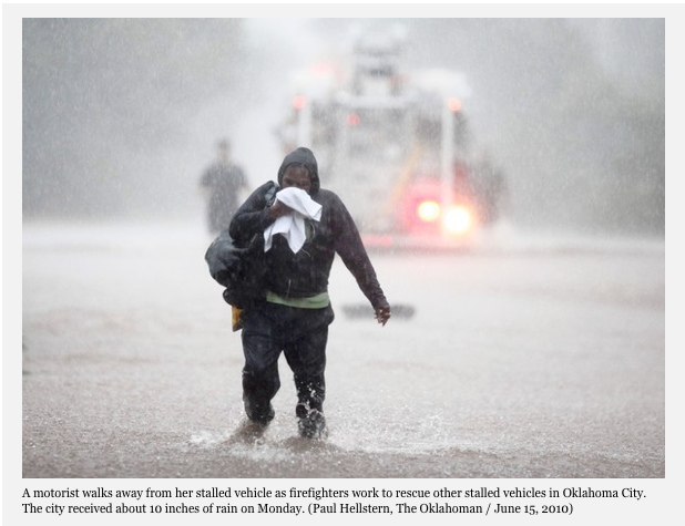
The warm and humid air has been sparking thunderstorms across the southern plains. Some locations in Oklahoma reported nearly 10 inches of rain yesterday producing rapid and severe flash floods. A sate of emergency has been declared in at least 59 counties.

Monday, June 14, 2010

Muggy week ahead

Ok so now I am o for 2 in the weekend weather forecast department since my return from North Carolina. However yesterday's error was much better than last Sundays. Despite the prediction for rain, we had sunny skies all day and warm temperatures around 26C. The weather was perfect for the Canadian Grand Prix here in Montreal. Today is showery but mild as a front settles south into New York State this morning. Skies will clear later today. The week looks fair but humid with the chance of showers and thunderstorms almost everyday right into next weekend.

Arkansas Flood
Crews continue the grim cleanup in Arkansas after heavy rains last Thursday night produced devastating flash floods early Friday morning along the Little Missouri River. Radar estimates show as much as 10 inches of rain fell in a short period of time. The river rose from 8 feet early in the evening to nearly 24 feet by morning moving through a National Park and campground sweeping away cars, cabins, trailers and people. Rescue crews have found 19 victims so far with one young girl still missing.

Flag Day
Today is flag day in the US. It also happens to be the day I became interested in weather. On June 14, 1966, it was a very warm and humid day in Montreal. High humidity pushed the temperature to 30C with a humidex of 36C or nearly 100F. There are several theories as to why I am into weather so much, one of them being that between 4-5pm in the afternoon, just as I was coming into this world, a fierce line of thunderstorms swept the Island of Montreal. The gusty winds, hail and heavy rain were accompanied by, as my mother described, the loudest thunder she has ever heard. It actually blew the back screen door off our home and allowed a large amount of water to pool in the kitchen. My mom figures this peaked my interest immediately and thus began the constant trek to the window, and years of wearing out carpets and curtains along the way until I moved into my own place. Anyway the interest in weather moves along into another year...

Friday, June 11, 2010

Weekend Update

It looks like Sunday's race here in Montreal may be
similar weatherwise to the 2000 race shown above
.

Words of advice, mow your lawn today, it may be too wet this weekend. Our dry May has been replaced by a cool and wet June. Very warm and muggy air sits just to our south, however a persistent track of potent late spring lows keeps on sliding along the US border from the Prairies across the Great Lakes and into Ontario and Quebec. This morning we are experiencing low clouds and some fog after yesterdays rain. Skies will slowly clear followed by a sunny and seasonable day. Saturday will turn more humid with showers and thunderstorms developing and sadly they will continue into Sunday affecting the Canadian Grand Prix. The race runs rain or shine, but typically water and the Circuit Gilles Villeneuve do not mix well. Monday looks like a washout as more rain and cool temperatures prevail before a gradual warming trend next week. Unfortunately work and the real world beckons so the entry will be short today. I will update the weekend forecast later today.

Wednesday, June 09, 2010

Unsettled weather returns

Despite the presence of high pressure and sunshine, yesterday was another in a series with popcorn showers and isolated thunderstorms in the afternoon. After my blog entry about how dry it has been and only receiving 38mm of rain for May, we have now had 44mm at the airport since June 1, and between 50-100mm in many other locations around the city. More rain is on the way. After a sunny day today, low pressure over the Great Lakes will swing east and produce another cloudy, cool and windy day Thursday, with periods of rain. Skies will clear out Friday and it will be pleasant into Saturday before the air mass becomes more humid with thunderstorms Sunday. Temperatures will be around 22C today, drop to the teens tomorrow with the cloud cover and rain and rebound to the mid 20's for the weekend. Looking into next week and beyond it appears that very warm and humid weather is on the way.

Leamington, Ontario tornado damage (Leamington Post photo)
F-2
Looking at some of the damage from Sunday's storm in southwest Ontario it appeared that the damage was much worse than an F-1 storm. My suspicions were confirmed yesterday when Environment Canada determined that the Leamington storm had damage along sections of its path that have qualified the storm as an F-2. Investigators found a two storey house that had been shifted on its foundation. A storm of this strength is capable of winds between 180 and 240km/h.

Tuesday, June 08, 2010

F-1 Tornado

Cool weather continues across most of Canada so far this June. This morning the temperature is only 0C (32F) in Churchill, Manitoba with freezing rain. The freezing rain is expected to change to a few centimetres of snow today. Meanwhile frost warnings are in effect for the lower north shore here in Quebec as well as the Saguenay and Lac St. Jean regions. The cool weather is expected to persist into the weekend. High pressure will dominate the region today with sunny skies but below normal temperatures. Low pressure will give southern Quebec and eastern Ontario showers late Wednesday into Thursday before skies clear out for another pleasant Friday. The weekend looks a little sketchy at this point, lets wait untill we get closer.

Environment Canada has confirmed an F-1 tornado in the Leamington area Saturday night. The damage path was 1km wide by 5km in length. A state of emergency is still in effect in Essex County due to the severe and extensive tree damage, as well as major power outages. Hydro One expects that it will take several days to repair and replace damaged lines, transformers and poles. Southwest Ontario was not the only region affected by severe weather on Saturday. During the afternoon hours several severe thunderstorms moved across eastern Ontario and western Quebec as far as the Island of Montreal. One of theses storms produced an F-1 tornado near Ste-Anne-de-Prescott in the extreme eastern part of Ontario. The storm caused considerable damage to several farms as well as uprooting trees and downing power lines as it pressed eastward towards the Quebec border and dissipated. According to Environment Canada the damage path was about 8km long and ranged in width from 20 to 30 metres. An F-1 tornado is capable of winds up to 180km/h. The tornadoes were the first two of the season for Ontario. Canada usually receives on average about 80 tornadoes each year.

Monday, June 07, 2010

Ontario tornado

Just some of the damage from Leamington, Ontario. (Leamington Post photo)

That was a brutal weather weekend, especially for the Tour de L'ile bike event in Montreal yesterday. The system that I thought would take most of rain south of us did not do as expected and made for a dreary, cold and wet Sunday here in Montreal. The heavy cloud cover and rain allowed the temperature to reach only 13C. On Saturday the first system produced a rather showery, warm and humid day with some thunderstorm activity in the afternoon. Rainfall was heavy at times, and I measured 60mm on Ile Perrot from the weekend rains, or nearly double the May total. The airport in Dorval to my east had considerably less, and this makes sense due to the isolated nature of Saturday's storms.

That same system on Saturday dragged a cold front across the upper Midwest and Great Lakes region. Numerous severe thunderstorms fired up late Saturday and into the pre-dawn hours Sunday across Illinois, southeast Michigan, northern Ohio and southwest Ontario. Several communities reported tornadoes that claimed at least 7 lives from Illinois into Ohio. In Ontario the town of Leamington southeast of Windsor was hit hard at around 3am Sunday morning. A potential tornado hit the community bringing down hundred year old trees on cars and homes and snapping power poles in half. The damage is very severe in many neighborhoods. Luckily nobody was hurt in the storm. Environment Canada will be investigating the storm damage today to determine if it was a micro burst, straight line winds or a tornado. Early reports from them indicate it was likely a F-1 tornado along the Lake Erie shoreline, however they continue to investigate.

Friday, June 04, 2010

Weekend Update

The image above is from NOAA in the US and shows the plume of smoke extending from the Quebec wildfires north of Montreal southeast across our region and into New England this past Monday.

Showers overnight have ended this morning with just some low clouds and fog persisting in most areas. Skies will clear out and it will be a sunny, slightly humid, and warm day with temperatures either side of 25C across the area. Low pressure in the Great Lakes will move across the St. Lawrence Valley with showers and thunderstorms beginning overnight and continuing into Saturday. The anticipated cloud cover will keep temperatures down around 20C both Saturday and Sunday. A second area of low pressure over the Ohio Valley will slide to the east and just to the south of Montreal on Sunday. The track of this system may keep most of the precipitation south of the city, but we can't rule out a stray shower. The annual Tour de L'Ile will be running in Montreal on Sunday with thousands of cyclists participating. While it will be a decent day, bringing a raincoat along for the ride is not a bad idea.

Thursday, June 03, 2010

Showery weekend ahead

Showers continued overnight providing the region with much needed moisture. Montreal ended last month with only 38mm of precipitation, that did include 0.2cm of snow on Mother's Day, but also a 35C high temperature reading last week. We are heading into a period of unsettled weather this weekend across Ontario and Quebec. Skies will be partly cloudy today with temperatures no better than 20C and the ever present chance of showers. Tomorrow will be the best day of the next four with sunny skies and temperatures warming to 26C. The weekend looks cloudy with a chance of showers and thunderstorms for the entire weekend and even into Monday. The damp and cooler weather is helping the forest fire situation here in Quebec. Firefighters are now battling 40 blazes down from 45 and more importantly only 5 are listed as out of control down from 16 last weekend. The air quality region wide has improved tremendously from this past Monday.

Tuesday, June 01, 2010

Some relief from poor air quality

When I posted yesterday morning I did not realize the extent of the smoke invasion from the forest fires here in Quebec. Bridget left me a comment about the smoke reaching Kemptville, and I noticed the visibility in Ottawa was quite low most of the morning, actually lower than here in Montreal. In addition to Ontario, advisories for the smoke were issued in New Hampshire, Vermont and New York and reports were received from as far south as Cape Cod. So what many thought was there own home on fire, was actually encompassing thousands of square kilometres.

This morning a welcome rain is falling across southern Quebec. The rain is scrubbing the air and helping knock down the dust and smoke. It will be beneficial for all regions regardless of how much falls. Radar is showing a wide area of rain in eastern Ontario and western Quebec that will slowly move east this morning. The relief will be short lived as Smog Warnings are already in effect for the metro region for later today and tomorrow. Warm and humid air will move back into the region overnight. Relief will arrive in the form of a cold front overnight tomorrow into Thursday morning.

June 1st is the official start of the Atlantic tropical season. We already had a taste of this last week as that non tropical low east of the Carolina's produced rough surf, beach erosion and lead to the deaths of at least 3 swimmers along beaches from new York to Florida. Forecasters are predicting a very active season with as many as 23 named storms, with up to 11 becoming hurricanes and several of those major storms (category 3 or higher). I will be watching the tropics closely as I have been since 1979, and several of the links on the left side of this blog will provide you with current information 24/7. Over the weekend the Pacific storm season began when Tropical Storm Agatha came onshore along the Guatemala/Mexican border. The heavy rains produced flash floods that killed at least 144 people in Guatemala, Honduras and El Salvador. More information can be found HERE

Monday, May 31, 2010

Smoky morning

Smoke reduces visibility over Montreal this morning. (CBC photo)

Vacation is over! It was a great two weeks in North Carolina but all good things must come to an end and reality settle in. When I arrived home yesterday, I was amazed to see how much grass can grow over a two week period. Equally amazing was how dry the soil was. I was pushing more dust around the neighborhood than grass clippings. Montreal has received only 38mm of rain this month, with most of that falling before the 15th.

That brings me to this morning. I had our windows open last night and thought our house was on fire at about 3am this morning. During the overnight, the wind shifted out of the northeast ahead of a warm front and brought smoke from the forest fires north of Montreal into the city. The thick haze is covering the city this morning with a distinct smell of burning forest in the air. These conditions will prevail most of the day with a shift in wind cleaning the air out slightly this afternoon. Nearly 55 fires are burning in the province with 8 out of control. About 1,200 firefighters, including some from Maine, New Brunswick, New Hampshire and Western Canada, are working to put the fires out.

Thursday, May 27, 2010

Heat Index over 100F

Montreal shattered its record high temperature yesterday at 34.7C, the previous record was 28.3 set in 1951. With the high humidity it felt like 40C or over 100F. The heat was stifled in the late afternoon when a fast moving line of thunderstorms moved from north to south across the island and into upstate New York. The fast moving storms dumped very little rain but produced high winds toppling some trees and a lightning strike that set a Hampstead home on fire. The temperature is a natural air conditioned 16C this morning and we will warm to a normal 25C. It will warm again over the weekend with an increase in humidity as well. The threat of thunderstorms has moved into the lower Hudson Valley today and metro New York City into the Middle Atlantic. To show you the effects of that rapidly moving cold front, yesterday at 4pm the temperature was 34C (95F) in Montreal while it was only 22C (72F) in Quebec City. Other record highs yesterday were 91F in Burlington and an amazing 99F in Hartford.

Here on the Outer Banks we are into our last full day. The forecast is improving with the effects of that coastal low diminishing. Temperatures will warm into the 80's today with seas and winds subsiding. We are off to Ocracoke Island for one last frolic on the beach. Then back north tomorrow through that front that is producing the severe weather. I may have some decent pictures by the end of the day.

Wednesday, May 26, 2010

Record heat

The rough surf on Hatteras Island reveals a shipwrecked barge from 1933. ValleyWX Pic


Lots to talk about on this Wednesday morning both here in North Carolina and at home in Montreal. First in Montreal, another record setting hot day is on tap before a backdoor cold front slices across the St. Lawrence Valley dropping temperatures by at least 10 degrees. yesterday Montreal reached 32C while Ottawa was 33C with a heat index of over 40C. Ottawa Hydro and Hydro 1 in Ontario are asking consumers to conserve power where possible. Meanwhile in Quebec the high heat and dry weather has elevated concerns about forest fires both in Montreal and across southern and central Quebec. Any outdoor burning is now prohibited until further notice by the provincial government.

Here in North Carolina on Hatteras Island the surf put on quite a show yesterday. Waves were running 4-7 feet with the beach virtually disappearing at high tide (photo 2). Some showers occurred as well with gusty northeast winds up to 30mph. The low pressure area causing this rough surf was located about 250 miles southeast of Cape Lookout. It generated enough interest to have The Weather Channel's Mike Seidel broadcast from Buxton this morning. The system will begin to move back out to sea with improving and warming conditions along the coast later today. Yesterday just at the end of our street along the beachfront, the rough surf uncovered the Flambeau wreck (named for the road it sits near). This is an iron and wood barge believed to have been grounded during a storm in 1933. I took photos in the morning when just a few metal bolts were visible (top photo), by the end of the day the entire outline of the barge was showing (photo 2). I am off this morning to see how much more is now visible.

More Outer Banks excitement yesterday as one of the ferries that runs between Ocracoke and Hatteras Island ran aground on a shoal in Hatteras Inlet and had to be towed off it. We have been on these boats dozens of times without incident but noticed on the weekend that they were having trouble with the narrowing channel. There were 27 vehicles and 45 passengers on board, but no injuries were reported. (See complete story here).

Tuesday, May 25, 2010

Record Heat

The satellite image this morning of the Atlantic east of North Carolina shows low pressure developing. As a result, high waves and surf are pounding the southeast coast today.

The heat is on in southern Quebec today. Temperatures will soar into the 30's, with a heat index pushing over 37C or 100F in both Montreal and Ottawa. The record high for Montreal today was 30.7C set in 2007, so it may fall. Skies will be hazy and the heat should last into the end of the week before a backdoor cold front cools off the region.

Here on the Outer Banks, low pressure continues to develop in the Bahamas and move very slowly towards the Carolina coast. The National Hurricane Center is monitoring the system, but the feeling is it will not reach tropical storm status at this time. Despite the lack of tropical characteristics, the surf continues to pound the coast this morning with rip currents and some beach erosion. A High Surf Advisory is in effect for coastal Dare and Hyde Counties through Wednesday. Seas along the beach are running 2-3 feet this morning and will increase 4-7 feet this afternoon. Winds are also on the increase out of the northeast between 15-25 mph.


Monday, May 24, 2010

The heat is on

Offshore thunderstorm cumulus clouds play with the moon last night on Hatteras Island, North Carolina.

Hot weather is streaming north into Quebec and Ontario on this holiday Monday. Temperatures under sunny and hazy skies will reach 30 to 32C (85-90F) in Montreal and eastern Ontario as well as northern New York. It could be a record breaker today, the previous record high for Montreal was 30.6C set in 2007. The weather will remain warm for the balance of the week before a cold front drops across the region by Friday.

Meanwhile we had a spectacular weekend here on the Outer Banks. Sunshine and 80 degree weather allowed us to kayak and beach it for most of the weekend. Last night an upper level low that has been keeping inland areas of the Carolina's wet yesterday began to produce an onshore flow. The result was a thundery rain most of the overnight that has continued into this morning. Some areas along the immediate coast have reported as much as 3 inches of rain. It was a spectacular evening last night with clear, moonlit skies on Hatteras Island, but just offshore in the Atlantic towering cumulus clouds put on a vivid lightning display. Combine that with the frequent glow from the Cape Hatteras lighthouse and it was a treat for the senses.

Now our attention turns to the tropical Atlantic. Low pressure is developing over the Bahamas and is expected to move slowly northwest towards the coast. Most models are predicting it to remain offshore. The counterclockwise flow around this system, combined with high pressure over New England will produce an onshore flow. A Coastal Weather Statement is indicating a high risk of rip currents as tides and swells begin to build along area beaches today. The storm will also increase winds along the coast to 15-25mph. At this time the low pressure is expected to remain offshore with just a slight probability of actually being named. The Outer Banks can expect gusty winds and high surf with some beach erosion, but at this time ocean overwash does not look likely. Stay tuned.

Saturday, May 22, 2010

Tropical threat?

Sunset over Pamlico Sound
I took the ferry back from Ocracoke Island at sunset last night. This is by far the best free ride/entertainment on the planet.

The weather is turning more summer like across eastern North America. High pressure will pump warm humid air up the eastern coast all the way into southern Quebec and eastern Ontario. Montreal will likely see its first 90 degree (32C) day this week. meanwhile that same high pressure will capture low pressure developing over the Bahamas, and depending on which computer model you believe bring it back towards the southeast coast as perhaps the first tropical system of the season. The season officially begins June 1, but really mother nature does not follow that schedule. Tropical systems have developed in just about every moth of the year.

If the scenario plays out as the European model would like it to, strong gale force winds and heavy rain could affect us here on the Outer Banks as early as late Monday. There is still lots of uncertainty with this forecast, but it bears close watching which I plan on doing from my vantage point 3 lots back from the mighty Atlantic. In any event warmer and more humid air is upon us, we are currently 74F with 82% RH here in Hatteras. Thunderstorms are a possibility this week at anytime in the sticky air. I will keep you up to date on this tropical threat. If the storm develops and is named, it would be called Alex. TROPICAL UPDATE HERE

Friday, May 21, 2010

Cape Hatteras Light

The Cape Hatteras Lighthouse in the Village of Buxton here on Hatteras Island is the symbol of the Outer Banks and coastal North Carolina. The lighthouse was constructed in 1870 and has stood the test of pounding surf and tremendous storms not to mention the salty air and a move. In 1999 the lighthouse was moved in an impressive operation about 1/2 mile inland. The 208 foot lighthouse, the tallest in the country, was in danger of tumbling into the relentless surf. Cape Point close to where the lighthouse is located is known as the Graveyard of the Atlantic. Pounding surf and constantly shifting tides are the result of the meeting of both the Gulf Stream and the Labrador Current. We visited the lighthouse yesterday, which is open to climbing, although we didn't this year. I took the picture on the right through the keepers quarters window. What a sight to wake up to every morning.
The lighthouse is visible from many parts of the island. Yesterday we walked the beach from Hatteras to Frisco about 5km north of here with the lighthouse in view in the distance the entire time.

The weather here has improved with sunny skies and temperatures in the 70's. The cool Atlantic waters are keeping the temperature in check here at the coast while it is rising into the 80's inland.

Weekend Update for Montreal
The weather in Montreal, Ontario and Quebec will turn HOT. After a cooler than normal weekend the heat will be on next week with humid, hazy weather and temperatures soaring into the 30's.

Thursday, May 20, 2010

Sunshine on Hatteras

A Hatteras Island fishing boat heads out into the Atlantic through Hatteras Inlet. ValleyWX Pic

The weather will do a flip today with sunshine and warm temperatures here on Hatteras Island and showers and thunderstorms back in Montreal. Both places will be mild today with temperatures in the 24 to 27C range. It will become increasingly more summer like along the entire eastern seaboard into the weekend with warm air extending all the way into southern Quebec. temperatures under sunny skies will reach close to 30C (86F) near Montreal and the upper 20's (75-85F) here along the coast of North Carolina.

Yesterday despite the cool weather and clouds I took the ferry over to Ocracoke Island. This is an awesome 40 minute ride across Hatteras inlet that I have done so many times before, and it did not disappoint again. The island is the southern most along the Outer Banks. It is a mere 12 miles long and about a half mile wide with a charming village at its southern tip and one road, State Highway 12, connecting the village to the ferry terminal. It is home to the Ocracoke Lighthouse, Ocracoke Ponies and of course Howard's Pub. Most of the island is controlled by the National Park Service, so the beaches are wide, flat and undisturbed. We took a walk at the northern end of the island and it felt like we were the only two people on earth. Walking along the sand bars and spits collecting seashells on a Wednesday afternoon is probably, for me, the best that life has to offer. I love this place.

Tuesday, May 18, 2010

Unsettled on the coast

Kitty Hawk Ocean Rescue training in the surf yesterday.

Heavy rain continued along the coast of North Carolina yesterday with one to two inches in many locations. I drove north about an hour or so to Nags Head in a gusty onshore wind and steady rain. Skies cleared a little in the afternoon and the precipitation ended. We are hoping to have some sunshine today, but it remains unsettled with the risk of thunderstorms. Temperatures have been around 23C which is a little below normal for mid-May. The seas were a little rough yesterday as well. I walked the beach in Kitty Hawk and took some photos (above) of the Ocean Rescue training in 60 degree water.

Today it is off to Ocracoke Island, chasing the sunshine south. That stubborn front remains nearly stationary with warmer air south and much cooler air north of us. I am noticing a line of thunderstorms to our southwest - so I may have some decent storm photos later on today. One thing is for certain, a cloudy day on Hatteras is still 1000 times better than a sunny day at work or really anywhere else!

More sunshine...but not here


Wind surfing on the Atlantic yesterday. This is a very popular sport for many on Hatteras Island, including many Canadians down here this week.

Greetings once again from Hatteras Island. The surf is up this morning with a moderate risk of rip currents, so activities may not involve water today, except for the rain. Heavy rain that remained along the coastal plain yesterday nudged its way onto Hatteras Island at around 4am this morning (I had to shut the patio door, it sounded like the ocean was in the house). The rain continues this morning with a gusty south wind but should taper off later today. No thunder yet, about 1-3 inches of rain has fallen across North Carolina since yesterday morning. Flooding was reported along the I-95 corridor near Rocky Mount yesterday and overnight.

As far as Montreal goes, great week for me to be away. Sunny skies and warm temperatures all week would likely mean not much to talk about on the blog. Enjoy the weather and the upcoming long weekend.

I will have pictures from Cape Hatteras and Nags Head later today.