Wednesday, July 18, 2012

Storm Update

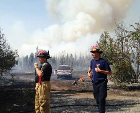
A state of emergency was declared in Potsdam, New York after thunderstorms produced widespread power outages and damage on Tuesday.
 (Watertown Daily News)
Tranquil weather is upon us for a few days with typical mid July weather. Look for sunshine and comfortable humidity with high temperatures from 26 to 28C (80-83F) across the region. The same holds true for both Thursday and Friday before we see an increase in humidity again into the weekend and an increased risk of showers and storms. Many areas received a good soaking rain yesterday, in the range of 25mm. It fell way to fast to give any long term relief from the drought, but it was welcome. Montreal recorded close to 37mm, the same as here on L'Ile Perrot. Apparently golf ball size hail fell here on L'Ile Perrot according to CJAD, but it must have been away from my location. No damage was evident here from hail or any other type of severe weather. This was most likely the same cell that produced the funnel cloud over Lac St. Louis. The 4:40pm storm was nasty for sure as it clipped the southwest corner of the Island of Montreal, Ile Perrot and the Vaudreuil/Soulanges area. Hail, between 2 and 5cm in diameter fell from St Anicet eastward towards Huntingdon, southern Quebec's tornado alley. Since I was a kid, and I imagine longer than that, thunderstorms have avoided the city on average and passed through the farming communities between the St. Lawrence River and US border.

The other story yesterday was the heat with more records falling across Ontario. Officially Montreal was just shy of 30C with cloud cover most of the day capping the temperature. This was not the case in Ontario where Toronto reached 36.8C, Windsor 37.8C, Kingston 33C, and Ottawa a sweltering 34.8C, all records for the day.

Tuesday, July 17, 2012

Thunderstorms sweep region

Taken through my window is what appears to be rotation in the clouds as a strong thunderstorm passed southwest of Pointe Claire on the West Island of Montreal on Tuesday. ValleyWX Pic
It was quite a stormy day in and around Montreal, particularly south of the city to the US border and beyond. Strong thunderstorms developed this afternoon in the hot tropical air and swept east. The mercury kissed 30C in Montreal before the storms and all the way up to 33C in Ottawa and a record breaking 36C in Toronto.

Major tree damage from afternoon storms in Athens, Ontario, north of Brockille. (The Weather Network)
The first of the storms fired up between Brockville and Ottawa and swept eastward into the St. Lawrence Valley and across the border area through Ormstown and Hemmigford and into New York. A second wave moved southeast across the Seaway and into northern New York. Those storms produced heavy damage in Potsdam, NY cutting power to 16,000 customers and toppling trees. A roof was torn from a downtown business in Potsdam. Southwest of Montreal, tree damage was reported in Summerstown, Ontario and golf ball size hail in St. Anicet. The heaviest of the storms stayed south of the city but we still managed 37mm of rain at my home here on L'Ile Perrot, most of that falling this morning. I have also posted a picture above of what I believed at the time was rotation in the clouds over Kirkland on the West Island of Montreal around 4:40pm. (Sorry for the window glare I was trapped in my office at the time). As it turned out a funnel cloud was spotted shortly after on Lac St Louis and tornado warnings were promptly issued for the South Shore and Richelieu Valley. I will have more damage reports by morning. The threat of severe weather has ended for the region and just a few showes are possible. It will be warm on Wednesday but a lot less humid.

Strong storms likely today

Humidex Advisory: Ontario and southern Quebec. Strong thunderstorms this afternoon.


A sultry air mass remains in place across most of Eastern Canada this morning with temperatures in the 20's and high humidity making it feel rather uncomfortable. A few thunderstorms dumped a decent amount of rain on L'Ile Perrot this morning with nearly 25mm (1 inch) since 6am this morning. The rain is most welcome and much needed but it will leave the atmosphere soaked with moisture and ripe for a strong outbreak of storms this afternoon. The NWS Storm Prediction Center in the US has placed northern New York and the St. Lawrence Valley as well as much of northern New England under a slight risk of severe storms this afternoon. A significant cold front and low pressure area moving into the warm and humid air will produce supercell thunderstorms with strong winds and hail, and even the risk of an isolated tornado. The storms this morning will move off to the southeast to be replaced by sunny breaks and hot temperatures near 30C (86F) in Montreal and into the 30's in Ontario. The cold front will begin advancing into the warm and humid air in Ontario during the afternoon and across southern Quebec, you guessed it, in time for Montreal rush hour.

Watches and Warnings are likely by noon across a large area of eastern Ontario from Kingston to Ottawa and east into Montreal and Quebec. I will tweet and update any warnings or watches all day long.

Sunday, July 15, 2012

Montreal - July 14, 1987


Top: Highway 20, one day after the July 14, 1987 storm, and still flooded.
Bottom: The flooded Decarie Expressway northbound lanes.
(Photos: Montreal Gazette)
Update: Monday, July 16 @ 7am: It is a very muggy start to the day in Montreal with temperatures expected to be hot again. Look for highs around 31C with a chance of thunderstorms. On Tuesday it will be even warmer with highs of 32 to 34C before a strong cold front produces heavy thunderstorms late in the day. We will need to follow that closely for the potential development of severe storms in southern Quebec, Ontario, NY and New England.

July 14, 1987: It was 25 years ago on Sunday that a series of strong thunderstorms swept across the Island of Montreal from south to north producing 100mm (4 inches) of rain in under 2 hours. The storms completely overwhelmed the municipal sewer systems flooding major roads and hundreds of homes. The Decarie Expressway flooded under several feet of water as did the St. Remi Tunnel, portions of Highway 20 and the Cote de Liesse highway. Not far from my Verdun home, in the suburb of LaSalle, power poles were leaning on a 45 degree angle, an indication of the powerful winds that accompanied the storms as they swept across the St. Lawrence River. The storm cut power to thousands for over 24 hours and generated nearly $200 million in damages. One fatality occurred when a motorist drowned in his vehicle in the Cote des Neiges district.
I was in Long Sault, Ontario at the time enjoying a camping trip, one of the few vacations I had at that time in my life. It would be the start for me of a stretch of missing all the big weather events in Montreal, that seems to continue today. I was also out of town when the big Ice Storm of 1998 hit and most recently the flooding thunderstorms this past May. It is either a sad irony for a weather geek, or God's way of protecting me!

Trucks sit submerged on the Decarie northbound just past Jean Talon.
(Montreal Gazette)
Back to 2012 - watering & outdoor burning ban
 After another record high on Saturday in Montreal at 33.3C, the city was a little cooler today at 31C (88F), however the humidity was quite high. We received about 11mm of much needed rain in an afternoon thunderstorm that swept the western portion of the city. The rain was accompanied by thunder and gusty winds. It remains cloudy still in the city and very humid with a muggy 24C at 9pm. Look for warm overnight lows tonight around 22C (72F) in Montreal, and another hot and humid day Monday pushing into the low 30's with high humidity readings. Despite the rain, water levels remain critical and outdoor fire bans and watering bans are in effect in most regions including here on L'Ile Perrot and across Vaudreuil/Soulanges County. There are at least 20 forest fires burning in the province and it remains very dry across the southern half of  Quebec and into eastern Ontario.

Friday, July 13, 2012

Level 2 drought

Lac St. Louis off the northern tip of L'Ile Perrot is nearly a foot below where it should be. Beach and rocks are exposed where water once was. ValleyWX Photo
I was writing yesterday about how critical the lack of rainfall is becoming across the region. Well today a Level 2 Drought (see below) is being declared by the Rideau Valley Conservation Authority, the first in over 10 years. This will include the entire Ottawa River watershed which stretches across the National Capital Region and communities on both sides of the border across Eastern Ontario and Western Quebec. Several Quebec communities draw water from the river including Rigaud, Pincourt and a large part of the municipality of Vaudreuil/Dorion.

In Vaudreuil/Dorion a ban on any outdoor use of water has been declared and residents are expected to reduce consumption by at least 20%. The Ottawa River is at a 10 year low which is prompting officials in the municipality to reduce outflow by up to 50%. Stiff fines are being imposed, up to $500 for violators. The ban includes washing your car and especially watering the lawn (I have seen so many violators already). The restrictions may be extended to other communities including Ile Perrot if rain does not come soon. A ban on any outdoor fires is also in effect for Vaudreuil/Dorion. Firefighters across eastern Ontario and western Quebec have been responding to brush fires, as the tinder dry grass burns easily.

How bad is it? Ottawa has just come off its warmest and driest 12 months in that cities history. Now we are in the middle of a week long period of hot weather with no rain, and this is expected to last well into next week with just a risk of isolated showers. Temperatures will hit at least 30C everyday into next Thursday. Since June 8th, Ottawa has recorded only 19.6mm of rain, or 20 per cent of their normal.

From the Ottawa Citizen, crews battle a brush fire in 33C heat yesterday near Richmond Road.
Here are three levels of drought in Ontario’s low water response plan.
Level 1 Benchmark: Precipitation level over three months or 18 months falls below 80 per cent of average.
Response: Voluntary 10 per cent reduction in water use among all sectors

Level 2 Benchmark: Precipitation level over one month, three months or 18 months falls to between 60 and 40 per cent of average following a confirmed Level 1 or Level 3 drought.
Response: Further voluntary 10 per cent water use reduction (20 per cent total)

Level 3 Benchmark: Precipitation level over one month, three months or 18 months falls below 40 per cent of average, following a confirmed Level 2 drought.
Response: Actions move from largely voluntary compliance to regulatory control.

Thursday, July 12, 2012

Warm and very dry

This message now appears on the municipal website for Vaudreuil and Dorion.
Water levels are way down across the Thousand Islands and the St. Lawrence River, making recreational boating a little more dangerous.
The weather continues to warm up this week but the evenings have been very pleasant. We managed a couple of 28C days in Montreal over the last two, but that will change beginning today as the heat and humidity slowly creep up into the weekend. High temperatures should hit 30C today and well into the 30's for the weekend and into next week. Any chances of rain will be very minimal as the extremely dry weather continues across Ontario and Quebec. I took a look at the rainfall for the past three months and it is not far from normal in Montreal. In May Trudeau Airport measured 91.8mm just a little above normal, 73.6mm in June (normal 83.1), and so far a dismal 21.0mm for July, with the normal being 91.3mm for the entire month. Most of that rain fell in one storm as did most of the rain in May. Add to that the scorching record high temperatures and a real water problem is beginning to evolve across the Great Lakes and Seaway on both sides of the border. Watering the lawn, filling your pool and washing the car may are now off limits in Vaudreuil/Dorion, and this may spread to other municipalities in the near future. A outdoor burning ban is also in effect for the region. A look west into Ontario, where our water comes from, shows even less rain with a paltry 12.7mm in Kemptville, with the normal being 97.5mm for July, and only 11mm in Toronto since mid June.

Low water levels on St. Lawrence River
The lack of snowfall and now rainfall has led to a 10 year low in water levels in the St. Lawrence Seaway. According to the St. Lawrence River Board of Control that oversees such issues on both side of the border, water levels are down nearly 10 inches below the normal. This has increased the danger in recreational boating as well as concerns over commercial shipping. If the trend continues, and at the moment it looks like it will for July anyway, the problems will only increase. As I mentioned already this week this is a developing story

Tuesday, July 10, 2012

Great weather week

The waterfront in Cornwall, Ontario this past Sunday. Little rain, with the exception of thunderstorms, and sweltering heat, has left the grass a dry yellow. Only 70mm of rain has fallen since June 1. (ValleyWX Photo)
I noticed this morning a little blip in our perfect weather week as some thunderstorms have popped up along a weak disturbance in the atmosphere, near Cornwall/Massena. This very narrow line of storms is sliding into upstate New York and should not be a problem in southern Quebec. Montreal managed a very pleasant high of 25C on Monday with low humidity and just a perfect day all around. The trend is expected to last all week as high pressure crests over the area. As that high moves off shore by Thursday a warmer and more humid southwest flow will develop pushing temperatures into the low 30's. The threat for showers and thunderstorms will also increase by Sunday.

Of Note: It remains hot on the prairies today with highs forecast in the mid 30's. yesterday portions of interior B.C. approached 37C (100F), while Val Marie in Saskatchewan hit 36C. The heatwave in the eastern US has dwindled into the southeast as some relief works its way south. It remains warm everywhere, in many cases upper 80's into the 90's but not as oppressive as the triple digit heat of the last two weeks. More thunderstorms are expected along the frontal boundary across eastern Virginia and the Carolina's as the cooler and drier air works its way south.

Monday, July 09, 2012

Cooler east - warmer west

Montreal was a comfortable 14C this morning as strong high pressure slowly drifts from west to east across the province this week. It was downright cold in some locations with Saranac Lake, NY in the Adirondacks recoding a low of 3C (39F). Temperatures will moderate across Ontario and Quebec from the record values of last week to more seasonable highs of 25C up to 30C by weeks end. Nothing but sunshine is in the forecast through Saturday. The heat and humidity has been pushed back south into the middle Atlantic states where more severe thunderstorms occurred over the weekend with at least fatality and at over 70,000 more without power in New Jersey alone.

Meanwhile the heat will begin to surge out of the desert southwest and across the plains into southern Saskatchewan and Manitoba. Temperatures will approach 115F in Arizona, Nevada and interior California this week with 100's surging north into Montana. In southern Saskatchewan we are looking at highs of 32 to 35C (90-95F).

Ten year low water levels on St. Lawrence River
The heat and dry weather in Quebec and especially Ontario has resulted in very low water levels on the St. Lawrence River around Montreal. The low water is creating difficult travel for pleasure craft with concerns that it will begin to affect commercial shipping. Additional concerns exist for the quality of the water with and increase in turbidity and bacteria levels. This will affect area beaches and more importantly could affect our drinking water. This is a developing story that you will here more on in the coming days. No rain is forecast through the end of the week with only spotty showers the week after.

Friday, July 06, 2012

Record heatwave moves east


New Yorkers flock to Coney Island Beach in triple digit heat.
The story continues to be sweltering temperatures from the deep southern US across the Ohio Valley and Middle Atlantic and into the Great Lakes, Northeast, Ontario and Quebec. Excessive heat advisories and humidex warnings are in place across two provinces including Montreal and at least 20 states as temperatures are generally expected to settle in between 32 and 37C (90-100F) today. That includes Montreal at 32C, we are already at 23C, Toronto at 36C and Windsor/Detroit at 37C. There may be a little relief in the form of a thunderstorm especially in southern Ontario and Quebec. Some relief is on the way for our region as temperatures moderate into the weekend with an outside chance of showers and thunderstorms. Montreal is looking at daytime highs around 28C through Sunday. Looking ahead at the middle and end of the month, it looks like more of the same, hot and dry. The heat is forecast to surge into the west next week with southern Saskatchewan and Manitoba hitting the mid 30's.

Montreal has been lucky, thunderstorms have helped to keep our rainfall totals at decent levels with 20mm this month and 74mm in June. Meanwhile Toronto has had only 11mm since June 11. The heat has proved deadly in many locations with two dozen deaths blamed on the weather in the US. Heat emergencies are in effect in many major east coast cities and some municipalities remain without power after last Friday's storms.

Flooding from Wednesday's storms in Burlington.
(Glenn Russell - Burlington Free Press)
Just a final not on the Wednesday night thunderstorms in Quebec and Vermont. The storm that produced 83 km/h winds in Montreal raced south of the city as a bow echo. Basically this is a line of thunderstorms shaped like a C bowing out in the middle with very strong and sudden winds. The gusts up over 110km/h tore down trees, capsized boats and flattened corn fields from Lacolle and Hemmingford southeast into Champlain, NY and across northern Vermont and into Burlington.

Thursday, July 05, 2012

Storms slam region

Strong thunderstorms move across Highway 20 in Beaconsfield yesterday afternoon. (ValleyWX Pic)
- 83km/h winds at Trudeau Airport
- Baseball size hail in Napierreville
- Large 2-3cm hail on West Island and South Shore
- Rock climber struck by lightning & killed, St. Raymond-de-portneuf.

It was another warm and humid day across Ontario and Quebec on Wednesday with the temperature soaring in places that lost cloud cover early. Toronto hit 36.3C breaking the old record by 0.2 degrees. Windsor was the hot spot in the country at 37.9C or 101F. Windsor's day was interesting to say the least with the daytime high of 38C recorded at 6pm and the daytime low of 18C one hour later at 7pm. The rapid cool down was thanks to strong thunderstorms moving south from Michigan with heavy rain, over 50mm.

Meanwhile Montreal managed to squeeze a 29C (85F) at the airport before big thunderstorms swept the region around 5pm. The storms moved across the island of Montreal from north to south at the worst possible time, rush hour, with heavy rain producing near zero visibility and slowing traffic to a crawl. One inch hail was also reported in the West Island and South Shore with the storm as well as strong gusty winds. Hydro Quebec reported power outages to about 20,000 subscribers in southern Quebec including about 9000 in Montreal. Only minor flooding was reported and other than a few tree branches being blown down, no damage was observed. The same line of storms swept into northern Vermont hitting Burlington around 7pm. They produced four foot waves on Lake Champlain submerging some boats. They also knocked down trees in the Queen City and cut power to thousands of homes and businesses. Numerous trees were knocked over blocking several major roads including Highway 2. Crews were kept busy removing fallen trees from roads and reopening nearly 10 in Burlington alone that were closed at the height of the thunderstorm.

Just some of the tree damage reported in Burlington, Vermont after big storms swept the Queen City around 7pm. (WCAX TV)
It will remain warm across the region into Saturday with daytime highs of 28C here in Montreal today, up to 33C in southwest Ontario. Tomorrow it will be even warmer with highs of 32C in Montreal up to 36C in Toronto and Windsor.

Wednesday, July 04, 2012

Happy 4th of July

Happy 4th of July. I took this photo on the Chesapeake Bay Bridge & Tunnel. (ValleyWX Pic)
It will be a warm and humid day across most of eastern North America on this 4th of July. Temperatures will rise once again into the 90's. A humidex advisory is in effect for southwest Ontario including the GTA for highs in the 33C (92F) range with humidex values over 40C. Here in Montreal it is a very muggy morning with temperatures around 21C (70F), and high temperatures forecast around 30C (86F). Ile Perrot had about 10mm of rain overnight as a few decent showers rolled through in the wee hours. We will have a lull in the activity for most of the morning before a weak cold front crosses the St. Lawrence Valley in the afternoon. There is an elevated risk of a few strong thunderstorms, perhaps producing small hail and heavy rain in southern Quebec and the St. Lawrence Valley by late afternoon.

Hydro One crews from Ontario work in 100F weather in Baltimore, Maryland yesterday, helping to restore power to millions. Meanwhile employees from Hydro Quebec will join them today. (Hydro One Photo)
This has been quite a year for violent thunderstorms across many areas on both sides of the border. The power is still out for hundreds of thousands in the middle Atlantic and Ohio Valley and several tornadoes were reported once again in southern Saskatchewan on Tuesday. I find it odd that in such an active year I have only witnessed two lowly thunderstorms this year, the least of my weather career. I guess it really is all about location, location, location. I missed the big storm here in the city back in late May, and most of the activity has either been west or south of Ile Perrot. My wife calls it my bubble that follows me everywhere, protects me, but I need a little more weather! Time for a road trip I think.

Tuesday, July 03, 2012

Warm with thunderstorms


It was a little cool to start the morning here on Ile Perrot with the temperature dropping to 14C (56F) just before sunrise. The warm July sun and increasing heat from the southwest have warmed us rapidly into the low 20's (23C / 73F) as of 7:30am. Today should be sunny and warm with little chance of any showers during the daylight hours. The likelihood of showers and thunderstorms will increase after midnight and continue into Wednesday across the St. Lawrence Valley as a complex of storms slides from the Midwest across the southern Great Lakes. Temperatures will warm to near 30C each day this week across southern Quebec and Ontario. It will be very humid across southwest Ontario with humidex advisories in place.


HYDRO ONE TO HELP: Meanwhile the heat continues across the eastern US with more records falling, nearly 200 last week alone. Hundreds of thousands are still without power after Friday nights storms making it very dangerous with 100F temperatures and no A/C. Damage is extensive and the restoration process will likely take the entire week. Hydro One from Ontario has sent down three crews with nearly 200 employees to help in the Washington DC & Baltimore metro areas, as well as Virginia.

Monday, July 02, 2012

Warm week ahead

After the storm - a ring of clearing appears after a Saturday afternoon thunderstorm in LaSalle, Quebec. (ValleyWX pic - PJ)
A warm and humid week is on tap for southern Quebec and Ontario. Some of that very hot and humid air over most of the eastern and central US will begin to lift north into our region. Temperatures will start the week in the upper 20's but warm to the low 30's by Wednesday with humidex values approaching 40C. There will be some clouds, showers and thunderstorms as well, starting as early as this afternoon. The rain will not be widespread but more isolated in nature in response to daytime heating and a few weak fronts. Drink plenty of water and keep the sunscreen handy this week. While we are not expecting any severe weather today, as with any thunderstorm, lightning is a real danger so move indoors at the first sound of thunder. Have a great holiday Monday.

Sunday, July 01, 2012

Prairie tornado threat

Strong storms southwest of Moose Jaw Sunday night. (TornadoHunter.ca)
Strong thunderstorms are developing across southern Saskatchewan tonight. Severe thunderstorm warnings and watches stretch along the Trans Canada Highway north and south to the US border. A tornado warning was in effect for the R.M. of Chaplin, west of Moose Jaw but has since been lowered. Strong storms are also affecting the Gravelbourg and Shamrock area northeast towards Moose Jaw. Hail, high winds and isolated tornadoes remain a threat through the evening.

Power cut to 3 million homes

HAPPY CANADA DAY - Ottawa a few minutes ago getting set for the big Canada Day concert. The weather is warm with a few clouds and an outside chance of a thunderstorm.
Thunderstorms are fickle animals at best. They can form quickly and yet dissipate just as fast. One late yesterday afternoon rained on my outdoor BBQ in Verdun when I assured everybody we were good for the day. It was a little embarrassing, but such is the nature of weather. We had another warm and humid day in Montreal reaching 31C (88F) before the storms arrived around 5pm. They were isolated in nature and cooled some areas while others such as here on Ile Perrot had nothing. Today is another humid day but a little cooler on this side of the border, perhaps hitting 28C. We had a shower early this morning, about 2mm of rain, and we may see another later today. It will be a warm and humid week with showers and thunderstorms and temperatures warming to over 30C most of the week.

Linwood, New Jersey thunderstorm damage. (Weather.com)
DERECHO: Our storms were pale in comparison to the massive outbreak of severe weather state side that stretched from Illinois south and east to New Jersey and Virginia overnight Friday and into early Saturday morning. The storms amalgamated together to form one large long lived thunderstorm complex that raced southeast and held together even into the overnight hours. This type of event is called a derecho (Spanish for straight), a widespread and long-lived, violent convectively induced straight-line windstorm that is associated with a fast-moving band of severe thunderstorms in the form of a squall line usually taking the form of a bow echo. This system was particularly violent and deadly coming after days of record heat. The storms cut power to more than 3 million homes and businesses prompting a state of emergency in several states including Ohio and Washington D.C. They also claimed the lives of at least 13, mostly crushed by falling trees, in homes, at campsites and in cars. The power may be out for days, with the heat continuing.

The storms left the region with no air conditioning on Saturday is sweltering heart that was just a little cooler than the all time records set Thursday and Friday. Included in those record highs was Atlanta at 106F and Nashville at 109F, the warmest since record began dating back to the Civil War days.

Friday, June 29, 2012

Long Weekend Weather


Happy Canada Day!

A few thunderstorms rattled across the region overnight, or so I was told. After three nights in a row of getting home at midnight, I slept through them. I noticed no appreciable wind gusts here overnight and just a splash of rain in the gauge this morning at 2.54 mm. It is 20C this morning, but a little more refreshing then last night with the rain clearing the air out a little. A very warm and humid air mass is set to invade the northeastern portion of the country with temperatures climbing to near 30C in Montreal and southern Quebec today. The heat will start today and last well into next week. It will be sunny to start both today and Saturday, but then become rather unsettled into the middle portion of next week with frequent thunderstorms. Intense heat is forecast up and down the eastern seaboard with heat index values well into the 100's. Numerous states have advisories or warnings posted for the dangerous combination of the heat and humidity. The warnings stretch from the Midwest and southern appalachians into the Carolinas and north to metro NYC. So far no warnings are in place for the heat north of the border, but a smog advisory has been posted for the GTA.


Canada Day Sunday looks great for the festivites in the Nation's Capital with high temperatures in the upper 20's and nothing but susnhine forecast at this time.

Wednesday, June 27, 2012

Severe weather pounds Saskatchewan

From Global.ca - A large tornado passes south of the Trans Canda Highway near Chaplin, SK.

This photo was taken by my friend Dayna Smith-Short north of Moose Jaw on Tuesday. I lived in Saskacthewan for 3 years and trust me there is no better place in Canada to watch and chase storms.
 SASKATCHEWAN - Strong storms swept across Saskatchewan on Tuesday promting numerous warnings. At one point the temperature was 9C in Calgary and 31C in Regina. When you have that kind of air mixing in the atmosphere combined with just the right amount of moisture and energy, you get severe weather. It was a big day for heavy weather across Saskatchewan Tuesday from Alberta east to the Manitoba border. It started early in the day with golf ball size hail reported at Consul at 9:30am. As the storms spread eastward they spawned a significant tornado between Moose Jaw and Swift Current just south of the Trans-Canada Highway. The storms pressed eastward with large hail, 120km/h winds and torrential rain into Saskatoon and Regina. Thousands are without power with SaskPower saying it could be days before all is restored. Trees were toppled and numerous accidents were reported on area highways. So far only minor injuries have been reported. There are still severe thunderstorm watches in place in the southeast part of the province this morning.

If you want more on yesterday's storms check out an incredible website at TORNADO HUNTER.

A fierce storm moves through Moose Jaw last evening. (Moose Jaw Times-Herald)

Tuesday, June 26, 2012

Up to 25 inches of rain from Tropical Storm Debby


A tornado spun off by Debby moves across the Florida Gulf Coast.

Back to work after a decant long weekend here in Quebec with sunshine and warm weather Saturday and Sunday giving way to showers and humid conditions on Monday. An upper level low spinning over upstate New York has been the focus of numerous showers and thunderstorms over the last 24 hours, some producing very heavy rain locally. The same will occur today with the axis of precipitation slipping slightly east of Montreal and Lake Champlain. Look for a few sunny breaks today but otherwise lost of clouds and perhaps a rumble of thunder. Temperatures will be below normal, perhaps hitting 20C if we receive a break or two of sunshine.
Point taken. (AP Photo)
Tropical Storm Debby
The moist air is being fed by a deep plume of tropical moisture that extends all the way down to tropical storm Debby in the Gulf of Mexico. Debby is nearly stationary off the Florida coast drifting east at 3mph. The storm has been pounding the coast all weekend with a 3 to 5 foot storm surge and up to 8 inches of rain. Nearly 2 feet of rain could fall by Friday as the system slowly crosses northern Florida and emerges in the Atlantic Ocean. Winds are at 45 mph and several tornadoes have been spun off by the storm. Two fatalities were reported and power is out to over 35,000 homes. Coastal flooding has closed some highways and heavy rain is producing inland floods.

Friday, June 22, 2012

Cooler & Drier

Just a few high clouds dot the sky in Montreal yesterday as temperatures again reached into the mid 30's. (ValleyWX)
As we head into the first of two consecutive long weekends here in Quebec, the weather is looking cooler and drier. We hit highs well into the 30's again on Thursday with 33.3C at the airport just short of the record high. Unofficially it was as warm as 36C on the island of Montreal with numerous stations reporting 34C including mine on L'Ile Perrot. Records were set yesterday at St Jean sur Richelieu at 33.8C, St Anicet at 34C, Cornwall 34C, Toronto 34.4C and Ottawa 34.6C.

This morning a weak cold front has cleared Montreal with no precipitation and winds are now out of the west. While it is still warm, it is noticeably drier. We are expecting a sunny day today and into the start of the weekend with warm temperatures near 27C. By Monday low pressure will be approaching southern Ontario and Quebec with showers and cooler weather expected into the middle of next week.

Thursday, June 21, 2012

Record Heat

Smog hangs over Toronto on Wednesday as the temperature soared to a record 34.6C. CTV News
Above: In response to a comment left by a reader asking about Ottawa's apparent record high, I just wanted to post the preliminary report made available by Environment Canada this morning regarding the record highs in Ontario on Wednesday.

Dozens of record highs fell once again across Ontario and Quebec yesterday as the temperature rose into the 30's. Ottawa was the warmest in the country at an even 35C breaking the old record of 34.8C set in 1988. Montreal also hit a record high of 32.7C (91F) topping the old one of 32C set in 1988. Toronto was under its second day of a heat emergency reaching a record breaking 34.6C. Other notable locations with record highs were Kingston and Kemptville in Ontario, St Anicet here in Quebec as well as Quebec City and Burlington, Vermont. The record high for Montreal today is 33.9C set in 1953, we have an outside shot at it.

High heat and humidity warnings remain in effect for today across southern Ontario and Quebec including Montreal. The temperature in Montreal is already at a warm 26C up from the "low" of 24C (76F), with temperatures expected to be in the 32 to 35C range and heat index values over 40C. Winds will be light and skies should be sunny but hazy all day. Yesterday we had some convective activity develop late in the day with thunderstorms forming along the St. Lawrence River and drifting south into the border region and upstate New York. Today we will not see any such activity. On Friday a cold front will approach from the west bringing in widely scattered thunderstorms as well as lower humidity and much cooler temperatures for the weekend.

Wednesday, June 20, 2012

Summer arrives today

High Heat & Humidity Warning

The summer solstice takes place at 7:09pm today in Montreal, with 15 hours and 41 minutes of daylight, so it is fitting that most of the region is under a high heat and humidity warning. Temperatures have already reached 26C here on L'Ile Perrot making it the warmest morning of the year so far. Factor in the humidity and you are already looking at real feel temperatures in the low 30's. That will only worsen today as the mercury creeps up to 32C to 37C (90 to 100F) across the southern portions of Ontario, Quebec and into New England and the Eastern Seaboard. The official high for Montreal is forecast to be 32C (90F). Depending on cloud cover and the arrival of air mass thunderstorms, we may or may not get warmer. In any event the humidex readings will be high all day reaching values between 35 and 40C making it feel rather uncomfortable for outdoor activities. Air quality will be poor in major metro areas such as Montreal, Toronto, New York and Washington. It will be even warmer on Thursday creeping into the 34C range here in metro Montreal. Any showers and storms that do occur will bring only slight relief and will actually elevate the humidity. It will be very warm and muggy overnight with lows only dropping to 23C. A cold front will usher in more seasonable and less humid air by Friday.

Summer arrives in Hampton Beach, NH and everywhere today. (ValleyWX Pic)
Heat Advisories & Warnings mean that the combination of high heat and humidity will make any outdoor activities quite dangerous if not deadly. Poor air quality especially affects those with respiratory illness. You are advised to remain in shady areas today, drink lots of liquids and take A/C breaks as needed. Pay attention to the very old and young and please remember your pets. NO time in a car is alone is appropriate for a dog in this kind of weather, I can't stress that enough.

Tuesday, June 19, 2012

High heat & humidity warning

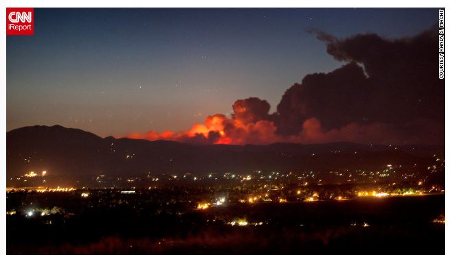
A spectacular night shot from a CNN viewer of fierce wildfires burning across northern Colorado where temperatures have been near 100F.
The intense heat that has been affecting the southern and southwest US is spreading north and east across the Ohio Valley and into southern Ontario and Quebec today. The combination of very warm temperatures and stifling humidity will make it dangerous for outdoor activities. Health officials have issued warnings in all three big east cities today including Toronto, Ottawa and Montreal metro areas. Temperatures will hold down today as a result of cloud cover, showers & thunderstorms. They are however expected to soar into the mid 30's on Wednesday and Thursday with humidex reading into the low 40's. The heat will push the mercury close to 37C (100F) in places like New York, Philadelphia and Washington. Health officials up and down the east coast are warning people to limit outdoor activities where possible, drink lots of water and seek A/C often to help lower body temperatures. My method of choice has always been a Corona by the Atlantic but short of that I guess I will have to settle for by air conditioned office.

The record high for Montreal today is 33.1C set in 2001. We will not hit that today as clouds are increasing and some showers and storms are moving across eastern Ontario this morning. We may have a shot at that or higher on Wednesday. Nighttime lows will stay very warm in Montreal remaining in the low to mid 20's in the city center. Relief will come by Friday as a cold front approaches the area.

Monday, June 18, 2012

Hot weather this week

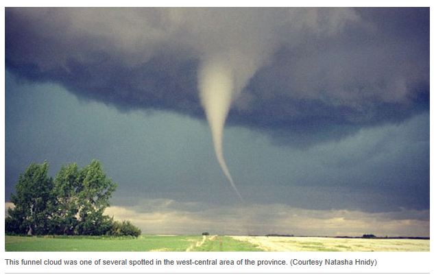
Numerous funnel clouds and tornadoes were reported in west central Saskatchewan on Friday afternoon. Minimal damage and no injuries were reported.
Environment Canada has issued a special weather statement for southern Ontario and Quebec as we look at our first prolonged heat of the season. Summer will arrive on Wednesday and right on schedule so will the high heat. We have had warm days this year, many as a matter of fact, but it looks like our first 32C (90F) temperatures will occur by Wednesday. High pressure will crest over the region with a strong southerly flow allowing warm air to move north along with increasing humidity. Humidex values will increase to near 40C on Wednesday and Thursday and air quality is expected to lower. The majority of the week will be dry, but several fronts will interact with the warm humid air, so there is a risk of some showers or thunderstorms, especially later in the week. A stronger front will arrive late Thursday into Friday bringing a more widespread threat of showers and storms, along with cooler temperatures on Friday. I expect highs in Montreal to be either side of 30C through Thursday. Overnight lows will be very mild, especially in urban areas, remaining in the low 20's (70's).

The leading edge of clouds from Hurricane Carlotta approach Mexico's Pacific coast on Friday.
Active weather occurred on Friday and over the weekend as thunderstorms and tornadoes swept across Saskatchewan and into the northern high plains. Meanwhile a strong hurricane Carlotta moved into central Mexico over the weekend and dissipated rapidly. The once category 2 storm slammed into Puerto Escondido south of Acapulco late Friday with 80mph winds and drenching rain. Damage was widespread along the coast with numerous building damaged and trees down. Mudslides were responsible for the deaths of two young girls.

Thursday, June 14, 2012

Abundant sunshine

Happy Flag Day! The stars and stripes with Mount Washington in the background. (ValleyWX Pic).
The image above shows it all, forecasts do not get any easier than this. Strong high pressure will settle into southern Quebec and affect all of Ontario and New England well into next week. As a result the entire forecast period is the same, sunny and dry days with highs from 23C today and Friday up to the low 30's by the start of next week. Lows will be seasonable to start around 12C but also warm into the mid teens. The high will slowly slide southeast off the Atlantic coast with an increase in humidity and perhaps some showers but not until late next week.

June 14, 1966 in Montreal. (double click to make it larger)
Today is Flag Day in the US and also my birthday! I can't believe how quickly the years pass, but life has been great to me and for that I am ever so thankful. I posted a snippet above of the weather on June 14, 1966, I was born between 4 and 5pm. As you can see it was a warm and humid day with what my mother had always described to me as a fierce thunderstorm when I was born. Apparently power was out and trees were knocked down. There is also a family rumor about us loosing a screen door at our home on the St. Lawrence River in Verdun. In any event it speaks volumes of both my fear, respect and love of weather.

Wednesday, June 13, 2012

Hot in Labrador - snow in Manitoba

A rare June snow in Gillam, Manitoba.. (The Weather Network)
I posted yesterday about the heat across far northern Quebec on Monday. Well the odd late spring weather of late continued Tuesday with more records falling in the far north, including the warmest place in the country, Goose Bay in Labrador at 34.5C. (96F) It was a record high for the community and one of the warmest June days on ever. Here in the south, clouds and showers managed to keep temperatures down in most locations, but we still managed a 26C (79F) here in Montreal. An area of rain moved through around 1pm dumping a quick 20mm on the city. That was followed by a solid line of thunderstorms that developed in Ontario, but they dissipated after sunset and just produced a shower or two last evening here in Montreal.

I wanted to mention the bizarre weather in Ontario and Manitoba this past weekend. On Friday a hailstorm moved across Cornwall, Ontario causing millions in damages. The storm was part of the same cell that produced a tornado near Huntingdon. Meanwhile in Manitoba strong thunderstorms produced hail as big as golf balls across southern portions of that province with major damage reported. Claims are still being assessed, but it could run into the tens of millions of dollars. In the north it was snow, in June! A record 20cm of snow fell on Gilliam, Manitoba surpassing the previous June record of 9cm. I still can't handle June snow, thankfully we have never had snow in June, July or August here in Montreal...so far!

Tuesday, June 12, 2012

Heavy showers today

Kuujjuarapik Airport on Hudson Bay (B) reached 31C yesterday, warmer than Montreal (A) at 30C.
The region will receive a break today from yesterdays sweltering heat and humidity. The mercury rose to 32.5C in Ottawa and 32.2C in Kemptville for some of the warmest readings in the country. Montreal reached 30.3C at the airport with 31C here on L'Ile Perrot and 32C southwest of Montreal in St Anicet. The heat spread all the way into far northwestern Quebec with Kuujjuarapik Airport on Hudson Bay reaching a record high of 31C (88F). (This is roughly 1125km from Montreal) This morning the airport was at 19C (66F) one hour ago, but reality has returned quickly with the wind blowing in off the water. The temperature has plummeted to 5C (41F) and they have 0.6km visibility in fog. Ouch - that is one quick turnaround!

Here in the south, cloud cover allowed temperatures to remain uncomfortably warm overnight and most areas are sitting close to 20C this morning. A slow moving cold front is inching its way across Ontario and heading for western Quebec. Gusty showers and perhaps some thunder are possible beginning this morning in the Ottawa Valley and spreading into Montreal by early afternoon. Some of the storms could produce heavy rain with some ponding of water on roads again, but not the generalized flash flooding of two weeks ago. In any event a good 25-40mm is not out of the question in many locations. The rain and showers will taper off by Wednesday, setting us up for a long period of sunny and warm weather into the weekend. With abundant sunshine temperatures will warm to 30C by Saturday.

Sunday, June 10, 2012

Huntingdon tornado confirmed

Heavy damage to a gas station near Huntingdon, Quebec from an F-1 tornado on Friday evening. (The Weather Network)
Severe thunderstorms split the Montreal area again on Friday moving across the downtown core and off to the southeast as well as southwest of my location here on L'Ile Perrot. The storms were quite strong to severe especially the cells that moved out of eastern Ontario and across the Valleyfield area and into upstate NY. Hail up to 1 inch in diameter along with heavy rain was observed. Quebec's third tornado of the young season was confirmed by Environment Canada as well, an F-1 (Enhanced Fujita Scale) touching down near Huntingdon southwest of metro Montreal. The storm hit around 5:30pm producing winds of 150 to 180km/h and causing severe but very local damage. A gas station was heavily damaged along with trees in the area. Power was also knocked out in the region. Normally the province reports 6 tornadoes in an average year.

Saturday was a much more quiet and dry day with pleasant highs close to 26C in Montreal. The heat and humidity will be on the rise today and Monday with temperatures near 30C both days and humidex values knocking on the 40C mark by Monday. The weather will be ideal for the Montreal Grand Prix today, but bring lots of sunscreen and water. A strong cold front and moist area of  low pressure will usher in cooler weather and some showers and storms by Tuesday. An active weather week lies ahead with several areas of low pressure and perhaps some tropical development making headlines from the Gulf Coast up the eastern seaboard. More on that Monday.

Friday, June 08, 2012

Strong storms possible

F-1 weekend is here and the weather looks perfect. Sebastian Vettel qualifying in Montreal in 2011.
Strong to severe thunderstorms are possible after the noon hour today across the St. Lawrence Valley of Quebec and Ontario and south into New York and Vermont. A trough of low pressure will be the focus to provide some lift and the daytime heating of the warm June sun will provide the energy. It is a warm and muggy morning at 17C and temperatures should rise rapidly into the mid 20's. Thunderstorm activity will begin to flare up by early afternoon. Any strong storms that do develop will be capable of gusty winds to 90km/h and small hail. I don't think we will see the prolonged flooding rains of last week, but with all thunderstorms localized heavy rain is possible. Yesterday some thunderstorms did develop late in the day but split the city moving west across Valleyfield and also east of the island. Light rain did fall here on L'Ile Perrot, but it was very brief and spotty.

The activity should come to an end by sunset with patchy fog overnight. At this time the F-1 weekend in Montreal, at least from a weather point of view look great. Sunshine and seasonably warm temperatures around 25C should prevail both Saturday and Sunday. Lets hope this spectacular event goes off without to much interruption from our professional protesters.

Thursday, June 07, 2012

Alberta tornado

An area of low pressure in the upper atmosphere continues to provide the region with enough instability to produce afternoon showers and thunderstorms. On Wednesday such was the case with sunshine to start the day followed by increasing pop up showers in southern Quebec with some thunder. Strong storms did develop in Ontario along a lake breeze. The storms produced hail, heavy rain and even the threat for tornadoes.

Today's showers should be weaker with drier air in place, there is just a 40% chance of some afternoon pesky raindrops. Temperatures will warm to near 22C. On Friday, early sunshine will transition into more showers and thunderstorms, this time a little stronger. Another disturbance in the atmosphere will interact with unstable air and produce a round of showers and storms in the afternoon from Ontario across southern Quebec and into northern New England. Some of the storms could contain small hail and strong winds, but it should not be a widespread severe weather outbreak.

By the weekend high pressure will settle in with a warm and humid period expected until the middle part of next week. Temperatures should approach 30C by Monday. With the heat and humidity, the risk for thunderstorms will increase into Tuesday.

Dust swirls around an apparent tornado near Taber, Alberta on Tuesday evening. (AP photo)
On Tuesday night a rare round of nighttime tornadoes spread across southern Alberta moving north from Montana between 6 and 10pm. There were no reports of injuries but Environment Canada is investigating at least 4 possible tornadoes in Alberta with several also reported in northern Montana.

Tuesday, June 05, 2012

June snow on Mt Washington

From the Mount Washington Observatory website, a photo of the crew building a June snowman on Monday. Below is my photo from last Sunday, taken on the same observatory deck, showing just how variable the weather can be on the summit.
A combination of an upper level low over the Great Lakes and a slow moving low off the New England coast, is keeping clouds, cool and showery weather over the region. The sun did peak out late yesterday afternoon in Montreal, and managed to push the temperature to 16C. We are close to that this morning as we start the day off partly sunny with a temperature at 17C here on L'Ile Perrot. The weather will remain unsettled into Friday with a smattering of sunshine, but also some pop up showers and maybe even a thunderstorm by Thursday. High pressure will then arrive by the weekend with a much warmer and gradually humid air mass. High temperature will approach 30C by late in the weekend or Monday.

Mount Washington observatory deck on Sunday, May 27. (ValleyWX Pic)
Mount Washington: What a difference a week can make or for that matter even a few hours on the summit of Mount Washington. Last Sunday, as regular readers know, I went to the top of New England's highest peak on what was an exceptional day with unlimited visibility, mild temperatures (49F) and light winds (35mph, light for Mount Washington). The day was near perfect for a visit. Yesterday however was a little different. As the observer described it in the briefing on the Mt Washington weather page, " expect to be met with FULL-ON WINTERTIME CONDITIONS above tree line," concluding with, "DO NOT UNDERESTIMATE THE MONTH OF JUNE ON MOUNT WASHINGTON." This was the case on Monday as that same coastal low affecting us pumped in cool, moist maritime air allowing for rime ice, fog and snow on the summit. On Monday snow accumulated several inches along with brisk winds at times over 50mph causing blowing snow and temperatures below freezing most of the time. Today will be just a tad milder but with more snow and ice and even a rumble of thunder. Use the link on the right hand side of this page to access their awesome website with web cams, photos and data.

Monday, June 04, 2012

Unsettled start to week

High surf  covers the beach and crashes along the seawall in North Hampton Beach, N.H. on Friday evening. (ValleyWX Pic)
Well it is back to the regular routine this morning, blogging from the not as picturesque L'Ile Perrot. It was a great visit to the New Hampshire Seacoast with decent weather for late May. What a joy to climb Mount Washington last Sunday and visit the top of New England. The peak has been the focus for lots of wild weather over the years including 200 mph plus winds on numerous occasions.

Today we are looking at more showery weather here in southern Quebec and extending into eastern Ontario and New England. Stubborn low pressure continues to spin east of Cape Cod feeding the area with a cool northeast marine air mass. We lucked out yesterday in Montreal with gusty showers all around us, but here in the city mostly sunny and mild most of the day. We are not so lucky this morning as the temperature is a very chilly 11C with a gusty northeast wind to 25km/h. Those winds will increase in the St. Lawrence Valley to between 30 and 50km/h today. So it will be cool and showery most of the day with highs no better than 16C. The good news is we should have a gradual warming trend by the end of the week with much warmer summer type weather by next weekend.

Over this past weekend, very heavy rain fell across portions of New England, primarily Maine and New Hampshire, areas that were already affected by major flooding last week. As much as 2 to 3 inches of rain soaked the area. Trust me it was raining hard, I drove home in it on Saturday. In addition the rain that coastal system has caused flooding and high surf from Massachusetts all the way northeast into Newfoundland including coastal areas of eastern Quebec. Watches and warnings are in place.

Friday, June 01, 2012

Rainy weekend

Sunrise this morning here in Hampton Beach. ValleyWX Pic
This is my last full day here on the Seacoast of New Hampshire. It has been a great week with good weather for late May. Sadly that is about change for all of us, including southern Quebec. Today is the meteorological start of summer, but you won't be able to tell this weekend. A strong low pressure and frontal system will move into the region from the Great Lakes and hang around well into next week. A soaking rain is forecast for the entire region from Ottawa into Montreal and south across New England. The amount of rainfall could easily exceed 50mm of 2 inches. Strong east winds up to 50km/h and cool temperatures around 16C are forecast both Saturday and Sunday. Showers will continue into next week. As a result of all the rain and flooding this week, water levels will have to be monitored closely for any possible warnings. The low pressure will slowly sink southeast into New England early next week maintaining clouds and showers well into Wednesday. Of note, I hope to have my data back online by Saturday night or Sunday.

The Seacoast: The forecast is the same here on the New England coast. The other factor here however will be high astronomical tides combined with the storm that could produce coastal flooding. A special weather statement has been posted and warnings may be needed. This morning was spectacular with a beautiful sunrise at 5:02 that I captured above.