Monday, September 10, 2012

Leslie heads for Newfoundland - Tornado in Drummondville

Tornado damage in Drummondville northeast of Montreal on Saturday. (CBC)
It was a busy weather weekend across eastern Canada with a strong frontal system and low pressure area sweeping across the area. The front produced strong winds close to 80km/h in southern Quebec along with damaging thunderstorms along its entire length from the Carolina's to Atlantic Canada. Some of the more notable damage occurred in the Drummondville region where Environment Canada has confirmed and F-0 tornado with damage to several homes and torn down trees and power lines. It was the 5th tornado in Quebec for 2012. The same front raced through Montreal around 4pm Saturday with 75km/h wind gusts. The wind and rain managed to cut power to over 90,000 Hydro Quebec customers across the province with most power being restored by Sunday morning. The front also produced several tornadoes in the US with one in the New York City metro area. The rare F-0 storm produced 100 to 120km/h winds and caused damage in the Queens and Brooklyn Burroughs of New York. The storm was also a rain producer with over 50mm reported in a wide swath of Ontario. In Montreal however the front was moving very quickly and only produced 10mm of rain as the city remains very dry.
A tornado taken from Coney Island sweeps across the NYC metro area. (NY Times)


Tropical Storm Leslie

Projected path of tropical storm Leslie.
Hurricane Watches are in effect for coastal areas of Newfoundland for the arrival of tropical storm Leslie on Tuesday morning. The storm which has been meandering in the Atlantic for two weeks, will finally accelerate off to the northeast today and rapidly approach Newfoundland. Aside form the coastal warnings, heavy rain and high wind warnings are in effect for the entire province along with rainfall warnings for Nova Scotia and P.E.I. The biggest threat will occur on Tuesday as winds increase to over 100km/h as does the the surf along the coast. Rainfall amounts will exceed 100mm (4 inches), with flooding likely. The area has been very wet over the last few days with as much as 75mm of rain. Leslie this morning has 60mph winds and is located 1395 kilometers from Cape Race, Newfoundland. The storm is moving to the northeast at 26km/h with an increase in forward speed expected. Some strengthening is possible over the next 24 hours with Leslie likely near hurricane status as she approaches Newfoundland.

Saturday, September 08, 2012

Strong thunderstorms today in Montreal

SEVERE THUNDERSTORM WATCH
Deepening low pressure is moving into southwest Ontario this morning. This system is trailing a potent cold front behind it that has been the focus for severe thunderstorms. This morning we have already had some thunder in Montreal, but the main event will occur later this afternoon along the cold front. For that reason Environment Canada has taken the unusual step of issuing a severe thunderstorm watch several hours before the effective threat. The watch is in effect for most of southern Quebec from 2pm until 8pm. The main area of low pressure will lift into the Ottawa Valley with heavy rain, up to 50mm. This morning thunderstorms are spreading across Ontario and into the National Capital Region. The threat for severe weather also applies to New England. The strong storms will move into Vermont later today and this evening. In advance of the system this morning, strong southerly winds will develop and gust over 50km/h in Montreal and up to 70km/h in the Richelieu Valley. Temperatures will warm into the mid to upper 20's today before a sharp drop this evening and Sunday into the teens. It will feel like fall on Sunday with a cold northwest wind, showers and high of only 19C

Friday, September 07, 2012

Weekend Update

There is plenty to talk about on this Friday morning, and with just a couple of summer weekends left in 2012, I wish I had better news. Today will be the best of the next three with sunshine and continued warm temperatures near 27C (81F). We had another warm and humid day Thursday before isolated strong thunderstorms popped up in the afternoon. Many regions were affected but for the most part the Montreal area was spared with no rain her on L'Ile Perrot.

After the sunshine of today clouds will be on the increase as low pressure develops in the Ohio Valley and move towards Buffalo and eventually Ottawa. This system will bring with it a period of heavy rain with embedded thunderstorms. The rain and thunderstorms will begin on Saturday with 20 to 40mm possible along the track and north of the system, less to the south. In addition to the rain strong winds will develop out of the southwest ahead of a potent cold front. The winds could exceed 50km/h with gusts as high as 70km/h especially in Montreal and the St. Lawrence Valley. Along the cold front strong thunderstorms are possible into the evening hours Saturday night. I will update this potential for severe weather later today and again on Saturday. Also check the twitter feeds on the upper left side of this page. Sunday will be cloudy and cool with gusty northwest winds and highs below normal, near 18C.
The projected path of  Leslie by the National Hurricane Center takes her close to the Avalon Peninsula by next Wednesday.
Hurricane Leslie
Just one more note this morning, Environment Canada continues to monitor the very slow and erratic moving hurricane Leslie. The storm has 75mph winds this morning and is located about 415 miles southeast of Bermuda, roughly where it was 24 hours ago. There is lots of uncertainty with this storm but she could be affecting a portion of Atlantic Canada by the middle of next week. I will be watching Leslie very closely through the weekend and posting updates via the blog, Facebook and twitter.

Thursday, September 06, 2012

Strong thunderstorms possible today in Ontario & Quebec

A weak cold front will move across eastern Ontario and southern Quebec this afternoon triggering some scattered showers and thunderstorms. While there is only a 40% chance of storms, any that do fire up will have the potential to produce heavy rain and gusty winds. Monitor the weather today for any watches or warnings that may be issued by Environment Canada. The weather remains warm and humid this morning after a high yesterday of 28C and humidex values well into the 30's, we only dropped into the high teens overnight. Temperatures will remain above normal today and Friday before a slight cooling trend into the weekend. After the showers today skies will clear overnight and set the stage for a sunny Friday. The weekend at this time looks wet as we begin the transition into a more fall like weather pattern.
A very impressive and powerful Hurricane Michael in the open waters of the Atlantic this morning with 115mph winds. This storm is no threat to land at this time.
TROPICAL UPDATE
The tropics are very active this week, starting with the remains of Isaac that brought very heavy rain to Atlantic Canada on Wednesday. Amounts were impressive with 50 to as much as 115mm of rain. We have two hurricanes in the open waters of the Atlantic Ocean. Hurricane Leslie has 75mph winds and is strengthening and forecast to move near Bermuda before possibly affecting Newfoundland by early next week. The storm is moving very slowly northward this morning at 1 mph, located about 440 miles from Bermuda. Leslie is producing pounding surf and riptides along the east coast of the US from the Carolinas northward into New England. Further to the east is powerful hurricane Michael located about 1020 miles southwest of the Azores. This storm is also crawling along in the open waters with no threat to land at this time. Michael is a strong category 3 storm with 115mph winds. Finally in an area that does not need more rain and wind, we have a low pressure area in the northern Gulf of Mexico off the coast of Louisiana. This system has a 50% chance of tropical development in the next 48 hours. Forecasters expect it to drift southeast into the Gulf of Mexico.

Wednesday, September 05, 2012

Flooding rains in southern Ontario

Flooding in the greater Toronto area from torrential rain on Tuesday. (CTV News)
Low pressure is moving eastward along the Quebec/Vermont border this morning after bringing a swath of very heavy rain to the region late Tuesday and overnight. Rainfall amounts were impressive with 44mm at Toronto, 100mm (4 inches) at Markham, 91mm at Kingston, 35mm at Kemptville, 54.4mm at St Anicet, Quebec and just over 20mm here on L'Ile Perrot. The heaviest rain in Quebec fell along the US border with between 50 and 75mm (2-3 inches) of rain from Valleyfield east into the Sherbrooke area. Rain continues this morning in extreme southeast Quebec, but it is tapering off. In its wake it will be another humid and muggy day with the threat for isolated showers and temperatures up to 26C.

For many reporting stations yesterday's rain was more than what had fallen in the entire month of August. Montreal only had 48.2mm of rain officially for August, so the 20mm on Tuesday was more than welcome.

Tuesday, September 04, 2012

Heavy rain moves over region

HEAVY RAIN WARNING

Low pressure over upstate New York is tapping into the moisture from former Hurricane Isaac and is pelting the area tonight. The heaviest rain was expected to remain over New England but has moved into Ontario and Quebec. It was a very humid day with heavy rain in southern Ontario. That rain has now spread into Quebec with 10mm here on L'Ile Perrot to 9pm. Amounts were impressive today in Ontario with between 25 and 75mm (1 to 3 inches).

Heavy rain warnings are in effect for the area south of the St. Lawrence River to the US border. Total amounts by morning could easily exceed 50mm (2 inches) especially in places like Vaudreuil, Valleyfield and Huntingdon as well as the Eastern Townships. Some thunderstorms are also possible overnight. If that amount falls, it will be more than what had been observed during the entire month of August.

Unsettled week ahead

Labor Day Weekend has come and gone and now meteorologically speaking, we are into the Fall season. However you could not tell that by this weekends weather and this morning's temperatures as Montreal is already at 21C (70F). We enjoyed sunshine for most of the holiday weekend with highs well above normal over 27C (80F).

Tropical moisture from the remains of Isaac as well as a frontal system will start to impact southern Quebec today with showers developing at anytime. The showers will increase in coverage late today as low pressure slides across southern Vermont. The heaviest rain will be confined to New England where 1 to 2" (25-50mm) are expected. Those amounts will taper of sharply in Ontario and Quebec with no more than 13mm (0.5") expected at this time. The balance of the week will remain rather muggy with scattered showers and perhaps a thunderstorm. Temperatures will remain in the mid 20's for daytime highs and upper teens for overnight lows. The normal high/low for Montreal for this date is 22/11C (72/52F).

Heavy rain floods neighborhoods just north of  downtown Washington DC on Sunday night. More flooding is  possible today as tropical moisture from Isaac hangs around. (Washington Post)
As mentioned the tropical moisture from what is left of Isaac is moving across the eastern US today. Heavy rain is forecast across Washington DC northeast into New York City with isolated flash flooding possible.

Friday, August 31, 2012

Warm & windy in Montreal

A sad image reminiscent of Hurricane Katrina 7 years ago. Army Corp Engineers cut a path through an earth levee to allow flood waters to drain from Braithwaite, Louisiana on Thursday. Two fatalities were reported in the area from Isaac. (Times-Picayune Photo)
It was a very warm overnight period in Montreal with temperatures staying above 21C (70F) and a very gusty at times strong southwest wind. Winds ahead of a cold front have been in the 40 to 60km/h range across the St. Lawrence Valley, nearly tropical storm force in gusts. It will continue windy today and warm with increasing humidity. Showers are dotting the radar this morning but they are light in nature. A better chance of showers and thunderstorms can be expected this afternoon as the main front crosses the area. Once clear of southern Quebec, we can expect a sunny and seasonable weekend with highs in the mid 20's and chilly overnight lows in the low teens. The fair weather will continue into Labor Day Monday before another front and the moisture from what is left of Isaac move into the region Tuesday. At this time rain is expected, but nothing excessive. I will begin to crunch the numbers on the summer of 2012 as we say goodbye to August. Typical meteorological summer runs from June 1 to August 31. Without looking at any stats, the obvious is true, it was warm and dry.

ISAAC : Speaking of the tropics, Isaac continues to meander as a tropical depression into Arkansas this morning. The remains will cross the Midwest with 3 to 8 inches of rain in the drought plagued region. Meanwhile the first two US fatalities of the storm were reported in a flooded home in Plaquemines Parish, Louisiana. Flood waters are slowly receding and clean up efforts are well underway.

KIRK & LESLIE : In the open waters of the Atlantic, we have tropical storm Leslie and Hurricane Kirk. Kirk has 105mph winds, but is not threat to land. Computer models have different opinions on the exact track of Tropical Storm Leslie at the moment, so she will bear watching.

Thursday, August 30, 2012

Isaac meanders over Louisiana - Leslie about to develop

A Facebook photo from  Suzy Dinger of roof top flooding after a levee broke in Braithwaite, Louisiana.
A tropical depression is about to form in the eastern Atlantic that could become Leslie. In the meantime Isaac continues to meander across Louisiana while Tropical Storm Kirk strengthens in the open waters of the Atlantic Ocean, with no threat to land. The US Coast Guard, National Guard, local Sheriff & State Police and the "Canjun Navy" everyday heroes in their own boats, have carried out and assisted in thousands of water rescues over the last 24 hours. 

Tropical Storm Isaac continues to slowly move northwest across the state of Louisiana this morning leaving in his wake severe flooding and nearly 750,000 without power. Water rescues continued overnight in the hard hit Parishes west and south of New Orleans. Flooding also spread from Lake Pontchartrain into the eastern suburbs. In some cases water levels have reached the roof tops of homes. This is eerily reminiscent of Hurricane Katrina, 7 years ago to the day. That storm all but destroyed a large section of Metro New Orleans with recovery efforts still visible to this day. Rainfall across the region has been beyond impressive with just over 19 inches in 24 hours in New Orleans. I can't tell you how hard is has to rain for that much to be recorded. Just think back to how hard it rained during Irene last year here in Montreal and we had only 2 to 3 inches in 24 hours. Both fresh water and surge flooding is widespread with much of Plaquemines Parish under water.

Lakeshore, Mississippi (Weather.com)
Meanwhile in Mississippi, surge flooding has damaged homes once again in Waveland along Highway 90 east to Gulfport. Tornadoes were also a problem across Mississippi on Wednesday with numerous storms damaging homes and tearing down trees and power poles. At first light today crews will spread out across the region for more search and rescue. Once the rain and wind settle down recovery efforts can begin. Power crews from nearly two dozen states are on the way to assist.

Wednesday, August 29, 2012

Isaac pounding Louisiana coast

An angry Lake Pontchartrain spills onto Lakeshore Drive in eastern New Orleans on Tuesday. (Photo from USA Today.com)
Hurricane Isaac continues a relentless assault on coastal Louisiana this morning. The storm is maintaining 80 mph winds and a very impressive circulation both on radar and satellite. Isaac is in better shape this morning than he has been his entire life cycle. The storm is moving painfully slowly inland over southern Louisiana at 6mph and will continue to do so today while gradually weakening. The storm surge has inundated areas south of New Orleans with as much as 9 feet of water. According to Plaquemines Parrish president Billy Nungesser, water has accumulated up to 5 feet at the Woodlawn Fire Department, more than during Hurricane Katrina 7 years ago today. Rainfall will be excessive with Isaac today across Mississippi and Louisiana with 15 to 20 inches possible. The heavy rain will spreads north into Arkansas and the Midwest. Over 450,000 homes and businesses are without power as off 7am this morning. Plaquemines Parrish is located southeast of New Orleans where the Mississippi River meets the Gulf of Mexico. It is low lying, at or below sea level, and as much water as land. Mandatory evacuations had been ordered but many remained and according to CNN numerous water rescues are taking place this morning with some homes flooded to there roofs.

It is way too early to tell if Isaac will impact the weather in southern Ontario and Quebec this weekend. For the time being high pressure will dominate with chilly nights and warm, sunny days. It was quite cool this morning with Montreal dropping to 11C (52F) and Ottawa a cold 6C (43F). The broad circulation around high pressure off the east coast and Isaac will actually pump warm and humid air into the region by Friday with highs near 30C.

Tuesday, August 28, 2012

Isaac makes landfall in Louisiana as a category 1

Waves crash along and onto Lakeshore Drive in New Orleans today. 
(Gerald Herbert AP)
Hurricane Isaac has touched land, briefly, in the Mississippi Delta at 7:45 ET with 80mph winds. It is moving northwest across the Bayou of southern Louisiana with pounding wind, waves and rain. It will reach solid land shortly just south of metro New Orleans. The storm comes onshore as a strengthening category 1 hurricane.

Storm surge flooding of up to 10 feet have been reported along the Gulf Coast in both Mississippi and on Grand Island, LA. Power is out to over 150,000 already across both states. Numerous roads are closed along the coastal areas as well as in metro New Orleans as flood waters rise. Winds of over 50 mph has been driving waves over the banks of Lake Pontchartrain tonight. Between 12 and 20 inches of rain is forecast with Isaac in New Orleans. Winds are expected to be in the 50 to 75 mph range but have gusted as high as 80mph along the coast and up to 106mph on an oil rig in the open waters of the Gulf.

Hurricane Isaac nears Mississippi Delta

Here is the latest visible satellite image showing Hurricane Isaac less than 55 miles from the mouth of the Mississippi River. The storm has 75mph winds and has devloped good outflow and an eye. Landfall is expected later this evening with heavy rain and a 6-12 foot storm surge in coastal Mississippi and southeast Louisiana including New Orleans.

Isaac becomes a Category 1 Hurricane

Major flooding hit South Florida on Monday from Tropical Storm Isaac, including Fort Myers Beach above.
11:20am Update: Isaac is now a hurricane with 75mph winds.

At this point, with tropical storm Isaac about 200 miles south of the Mississippi coast, whether the storm becomes a hurricane or not is really not important. What is important is that we have a large storm with a significant storm surge and lots of rainfall approaching the coast. Preparations and evacuations should be completed early this morning. Isaac is still forecast to reach hurricane strength before moving onshore late today or in the wee hours of Wednesday. The storm has continued to remain just below hurricane status with 70mph winds. The center is expected to slow from the current speed of 12mph and strengthen before landfall. The big concern right now is with the water component of this storm. A Gulf of Mexico surge of 6 to 12 feet is expected along the low shorelines of Mississippi and southeast Louisiana. It was 7 years ago this week that Katrina hit the same area with devastating flooding and over 1800 deaths. Since then billions has been spent on the levees and pumps protecting New Orleans, this will be a test of that system. Once inland flooding is forecast from 10 to 20 inches (250-500mm)  of rain that will deluge the region from the deep south into the Midwest.  Yesterday squalls from Isaac pounded south Florida with 6 to 12 inches (150-300mm) of rain and heavy flooding. Roads and homes were inundated. Isolated tornadoes were also reported and can be expected as Isaac makes landfall this evening.

Looking well ahead into Labor Day weekend, some computer models have rain from Isaac approaching New England and southern Quebec. At this time it is way too far out to predict. We may continue to be protected by strong high pressure that has been steering the storm west into the Gulf and away frown the east coast.

MONTREAL: Yesterday the city had another warm day with the high reaching 28C (83F) before clouds and just a splash of rain occurred. It was not nearly enough to get us out of what has been a dry summer and  especially the month of August. Montreal has recorded less than 50mm of rain for the month, most of that falling in two separate thunderstorms in less than one hour each. The balance is spread across minor events of 1 or 2mm. The lack of rain has left water levels dangerously low, watering bans in effect, and trees and lawns dying.

Monday, August 27, 2012

Isaac heads for Gulf Coast

Isaac is becoming better organized this morning. The image above is from 8:15am.
There is lots to blog about on this Monday morning. Lets start locally where summer is going out the same way it started, hot. Very warm and dry weather has prevailed in Ontario and Quebec most of this summer and this weekend was no different. Temperatures under brilliant sunshine reached 32C (90F) in Montreal Saturday and Sunday. The week looks warm with temperatures lowering slightly with cloud cover and some thunderstorms today into the upper 20's. The middle week looks sunny and dry and a little more seasonable before another surge of hot air arrives for Labor Day weekend. Temperatures by Friday could be in the low 30's once again. We will have to watch what the remains of Isaac do next weekend but that is way too far out at this time. To be honest we could use the rain. Most of the trees in my neighborhood are drying up with the green leaves falling off the trees. It has been many years since I have seen this.
High winds and rain in Key West, Florida on Sunday. (Getty Images)
ISAAC
Speaking of Isaac, forecasters are having a difficult time with this system that has threatened to reach the 74mph threshold for a hurricane but just has not been able to. The many computer models that predict the storm track have Isaac coming onshore anywhere from Louisiana to the Florida Panhandle.We are still expecting Isaac to pull together and become a strong storm in the next 24-48 hours. This morning the elongated and poorly organized center of Isaac is located about 405 miles southeast of the mouth of the Mississippi River. Recent model runs have been placing the likely location for landfall further west, therefore Hurricane Warnings are now in effect from Morgan City, Louisiana to Destin Florida. This include metro New Orleans and Lake Pontchartrain. While Isaac only has 65mph winds this morning, the water and air in his path are extremely favorable for strengthening today into tonight. All resident in the warning area should be preparing their plans for Isaac now. While Isaac is taking a similar path as Katrina did 7 years ago almost to the date, the similarities at this time stop there. Time will tell just how strong Isaac wants to become. The Florida Keys and south Florida were spared a direct hit but heavy rain did cause some flooding and winds produced power outages to about 20,000 residents.

In Haiti and eastern Cuba heavy rains and mudslides produced major flooding that destroyed some homes and killed at least 7 people.

Sunday, August 26, 2012

Isaac close to hurricane strength

Key West radar in the last hour showing the outer edges of Isaac moving onshore. The Cuban coast is in the bottom of the image.
Tropical storm Isaac is just off the Cuban coast this morning about 135 miles east southeast of Key West. The storm has 65mph winds and is forecast to reach hurricane status as he passes through the western Keys. Hurricane warnings are flying through the Keys as well as along the west coast of Florida. Molasses Reef observed a wind gust to 54mph (87km/h) in the last hour. A hurricane watch has now been posted for the Gulf Coast from the mouth of the Mississippi River to Indian Pass, Florida. The storm is moving at a decent rate of 20mph this morning, but forecasters expect the system to consolidate and slow down its forward speed. This will likely allow Isaac to gain strength and approach the Gulf Coast as a strong hurricane by Tuesday morning. Isaac has been rather elongated and poorly organized from the onset but this has not stopped the storm from producing flooding rain across Haiti and winds strong enough to topple trees. Strong surf has also battered the coastal areas of Haiti and Cuba. The flash floods and mudslides in Haiti have taken a toll, especially on the tent camps that were set up after the 2010 earthquake. Several fatalities were reported in Haiti. Storm preparations should begin today across the Gulf Coast.

I will update the status of Isaac as the day progresses. The main impacts today will be heavy rain and gusty winds to the Florida Keys and Cuba.

Saturday, August 25, 2012

Isaac update

A spectacular NOAA image of the inside of Tropical Storm Isaac, taken early Thursday morning.
Tropical storm Isaac has assumed a northwest motion at 14mph and has crossed over extreme southwest Haiti this morning. Isaac has 60mph winds and is located about 95 miles south of Guantanamo, Cuba. The storm is now taking aim at extreme eastern Cuba and eventually the Florida Keys. Forecasters  with NHC expect Isaac to increase in strength and reach hurricane force over the next 24 hours. The storm is forecast to cross the Florida Keys on Sunday. For that reason a hurricane warning is now in effect for the Florida Keys including the Dry Tortugas and the the west coast of Florida from Bonita Beach to Florida Bay. Conditions will rapidly deteriorate over the next 24 hours as the extreme outer rain bands begin to affect the keys. At 9am Key West was reporting 36mph wind gusts and heavy rain. Beyond 24 hours all interests along the Gulf Coast need to monitor Isaac. This storm has the potential to rapidly gain strength and become a strong storm before affecting the region between New Orleans and the big bend area of Florida with the focus being on the Panama City/Pensacola area at this time.

The next Isaac update on my blog will be near 7pm with Twitter feeds all day.

Friday, August 24, 2012

Perfect late summer weekend

They don't not come any better than this upcoming weekend's forecast for Montreal and eastern Ontario. Strong high pressure will be in control of the weather with warm sunshine pushing temperatures very close to 30C. This is easily 5 to 7 degrees above normal for late August. Overnight lows will be pleasant dropping back into the teens. So it is A/C during the day and windows open at night. There really is not much else to tell, enjoy the weather.

Deep convection is beginning to spread out in large tropical storm Isaac. Winds are only 45mph but strengthening is forecast. Isaac will produce heavy rains and flooding today across Puerto Rico and the Dominican Republic into Haiti.
Tropical Storm Isaac
Things will begin to break down by Monday in Montreal with the approach of a strong cold front introducing some showers and thunderstorms to the area along with slightly cooler weather. Our focus will then turn to developing Tropical Storm Isaac and the impacts expected locally. Isaac this morning is strengthening a little as he sits 165 miles south of Santo Domingo. Forecasters expect Isaac to increase in strength today with a slight risk of reaching hurricane status before interacting with Cuba and Haiti. Beyond 48 hours into this weekend we are looking at Isaac re-emerging over the open waters of the Straits of Florida near Key West and moving into the eastern Gulf of Mexico. Depending on how much time Isaac has to develop we may be dealing with a major hurricane approaching the the Mississippi/Alabama Gulf Coast by Tuesday. Once inland the storm will move into the Ohio Valley and could bring rain and wind by the middle of next week to Quebec. We need to watch this storm carefully and I will update the blog all weekend as well as the twitter feeds on the left. There is the potential for this storm to cause serious flooding and mudslides today across Haiti and the Dominican. Rainfall totals could exceed 10 inches. A state of emergency may be declared later today for the Florida Keys. Interests all along the Gulf Coast from New Orleans to the big bend of Florida need to begin to listen to the forecast very carefully and review there hurricane plans.

Thursday, August 23, 2012

Weak Isaac passes near Leeward Islands

Tropical Storm Isaac in the lower right portion of the loop is expected to strengthen.
Tropical Storm Isaac continues to suck in dry air this morning keeping a cap on any rapid development. The storm remains about 255 miles southeast of San Jaun, Puerto Rico moving west at 12 mph with 45mph winds. A NOAA Recon Flight into the system found Isaac slightly weaker and a little further south. The storm is still forecast to gain strength and likely reach hurricane status before brushing Hispaniola and eastern Cuba. Once into the straits of Florida re-development is likely. At this time it is difficult to say what the impacts will be on Florida and the Eastern US, but there will be some. It is unlikely at this time for New England and southern Quebec that we are looking at another Irene. For the time being the focus of attention will be on Haiti and the Dominican Republic where even a modest tropical storm can produce severe and life threatening floods.

The forecast track of Isaac into the day 3 to 5 time frame now has the storm affecting Key West and the west coast of Florida as he rides around a strong ridge of high pressure along the east coast. That Bermuda high will give southern Quebec and Ontario spectacular late summer weather into the weekend with juts a slight chance of showers and thunderstorms and daytime highs near 30C.

Wednesday, August 22, 2012

Tropical Storm Isaac forms

After a guarantee of a spectacular week, we had a few surprise showers yesterday, especially across Eastern Ontario and the Ottawa Valley. The afternoon was generally cloudy but mild in Montreal. Skies have cleared out early this morning and we should have a sunny day with temperatures a few degrees warmer than on Tuesday. Look for high temperatures to settle into the 24 to 27C range. L'Ile Perrot currently sits at our low for the night 15C, as the clouds cleared out late. The forecast looks unchanged, strong high pressure will keep fair skies and warm temperatures across the Ohio Valley and Ontario, northeast into New England, New York and Quebec. Look for a great spell of late summer weather. The only threat for any precipitation will come late in the afternoon on Thursday and Friday with just a slight chance of a shower or rumble of thunder.

Wednesday morning NOAA image of Isaac (center) along with the next potential storm (lower right). South Florida and Cuba are on the upper left side of the image.
TROPICAL STORM ISAAC
Meanwhile Tropical Storm Isaac developed late Tuesday as expected and it now moving towards the Leeward Islands and Puerto Rico at about 18mph. Warnings have been raised across the Leeward & Windward Islands, Puerto Rico, the Virgin Islands, Haiti and the Dominican. Forecasters at the National Hurricane Center are saying the storm is becoming better organized and could be a hurricane within 24 hours. The 3 to 5 day forecast has Isaac approaching extreme south Florida by the pre-dawn hours of Monday morning. This is very far out for any forecast let alone a tropical one, so lots can change. In any event Isaac is poised to be a weather maker for the eastern coast of the US and possibly Canada down the road as we head towards the first anniversary of Hurricane Irene.

Tuesday, August 21, 2012

Spectacular weather week

As September 1 looms on the horizon and the end to meteorological summer, we are being treated to one awesome weather week. This is the type of weather I think everyone can enjoy, bright sunny days around 27C and cool crisp nights in the low teens. The trees are changing color in some cases and the mornings have been a little chilly walking the dog, but I refuse to give up the t-shirts and shorts. They will be around through September, I am stubborn that way. So with high pressure dominating the weather scene here in Quebec and eastern Ontario, we have to look elsewhere for weather to write about.
From the National Hurricane Center, the potential path of soon to be Tropical Storm Isaac as we head into this weekend.
Tropical Storm Isaac?
The tropics have been fairly active lately, but with most systems being rather weak or disorganized and affecting largely the open ocean. That may be about to change as we have TD 9 in the Atlantic Ocean this morning, 1150 kilometres east of the Leeward Islands. This storm will likely become tropical storm Isaac by later today as winds exceed 39mph. At this time forecasters expect Isaac to become a major system approaching and passing through the Leeward and Windward Islands by Thursday before heading for Puerto Rico. Conditions for this system to develop into a hurricane are ideal with little shear and lots of warm water. We are looking at the potential for a major hurricane by the weekend and into next week. At this time impacts to the US are difficult to assess, but we will ave a storm heading across the Caribbean Sea and possibly towards south Florida or the Gulf. Keep in mind that we are entering the most active time of the tropical season. As a side note, since 2001 the WMO has retired 7 "I" storms including Irene from 2011 that left her mark up and down the east coast from Caper Hatteras to Vermont, southern Quebec and Atlantic Canada. Forecasters are also watching two other areas of interest one just off the African coast and the second area in the southern Gulf of Mexico east of Veracruz, Mexico.

Thursday, August 16, 2012

The final days of summer?

The end is near, but not here just yet. The mornings tell the tale of a changing season. Walking the dog now is done as the sun is coming up which each day getting a little later. The one thing I notice is the heavy dew that settles on everything as the longer nights begin to establish themselves. The third thing is our overnight lows have quietly slipped into the teens. I recorded 16C (61F) here on L'Ile Perrot just before the 5:58 sunrise this morning. We are at about 14 hours of daylight and loosing 2 to 3 minutes per day.

Jacques Villeneuve in the rain in 2008 on the course named after his dad. It looks like dry weather for this Saturdays NASCAR event.
It is not all doom and gloom, the weather has been about near normal for August. There has been lots of sunshine, and what rain that has fallen, about 50mm At Trudeau, has come in brief shots. Even last weekend which was forecast to be a washout turned out to have more sun than cloud. This brings us to the current forecast which is showing nothing but sunshine for the region today. Temperatures will settle in to the 27C (80F) mark by late afternoon. Clouds will develop overnight as a cold front approaches the Valley. Showers and perhaps a thunderstorm for Friday before late clearing and a sunny but cooler weekend. Temperatures will feel a little like fall this weekend with highs around 23C and lows dropping to 14C. Look for sunshine from Saturday into the middle of next week. The forecast means a dry NASCAR NAPA Auto Parts 200 at Circuit Gilles Villeneuve on Saturday. Good news for a race that has been tormented by rain every year since 2008. The only 100% dry event was the first one in 2007. I know because I have sat in the rain each year! Lets hope we have a dry green to checkers event this year.

Tuesday, August 14, 2012

More thunderstorms today - rain for NASCAR?

Snow! Yes snow on the map this morning across northern Nunavut. As a matter of fact up to 5cm of snow, along with 50-70km/h winds are forecast for Resolute tonight with temperatures steady near 0C (32F). There my friends are the first signs of the changing seasons. You can feel it in the air as we approach mid August. A few of the trees are showing some color, the nights are getting longer and the dew a little thicker. The 32's of July have become the 28's of August.

Will rain occur again this year for NASCAR? Ron Fellows winning in the rain in 2008.
There is till some summer left and it will be that way today with hazy sunshine to start we are siting at a humid 21C (70F) at Trudeau Airport. Temperatures will rise to near 27C (80F) today with an increasing chance of showers and thunderstorms. The showers will taper off after sunset with another cloudy humid day on tap for Wednesday and more showers. The balance of the week right into the weekend looks unsettled at this point with showers each day. We will have to watch the forecast and the threat of rain into Friday and Saturday, as the NASCAR Nationwide Series will be running in Montreal at Circuit Gilles Villeneuve.

Monday, August 13, 2012

Microburst confirmed in Rosemere

Storm damage from Rosemere north of Montreal. (GIRARD PASCAL/QMI AGENCY)
Low pressure over Lake Ontario most of this weekend was enough to keep lots of showers and thunderstorms across the region. Add to that the instability of lots of unexpected sunshine on Saturday and the stage was set for some powerful thunderstorms. The storms fired up in northern New York and extreme southwest Quebec late Saturday afternoon, rapidly moving from south to north into the Montreal region. It was mostly a heavy rain event for L'Ile Perrot with just over 25mm (1 inch) in under an hour. We have excellent drainage here on the Island so no problems were reported. The same was not true in other areas of the metro region. The storms produced heavy flooding particularly northeast of the city. Damage was reported also in Laval and north of Montreal in Rosemere and Terrbonne. Environment Canada has confirmed that a microburst occurred in Rosemere on Saturday around 5pm. The storm produced large hail and winds in excess of 120km/h toppling numerous large of trees and tearing down power lines. Sadly, 18 year old Vanier College student Matthew Salsa was killed on the course when he took refuge under a tree that crashed onto him. There were numerous reports of trees down and hail across the area north of Montreal from Lachute east to St Janvier and Repentigny. 4cm hail was reported with the storm as well as 50-70mm of rain.

We start the day rather humid again with temperatures at 20C. They have been at 20C for the last 5 hours. This has become the temperature of choice for the city lately with 14 consecutive hours of 20C (68F) readings observed from 5pm Saturday until early yesterday morning at Trudeau Airport. The day will be sunny with only a slight chance of a shower. Tuesday into Wednesday will be a little more active with more warm and humid weather and the chance for some strong afternoon thunderstorms.

Friday, August 10, 2012

Plenty of rain & thunderstorms

Showers continue this morning across a wide swath of southern Ontario and Quebec as a warm front lies over the region. There is even some strong thunderstorms embedded in the rain including one just moving ashore of Lake Ontario into the GTA. Some of theses storms even have the likelihood of a waterspout, primarily over Lakes Erie and Huron, closer to the spin of low pressure. This front will be the focus for heavy showers and storms most of the day into the overnight and Saturday. It won't rain all the time, but when it does it could be heavy. A general, and much needed, 25-50mm (1-2 inches) is forecast by Saturday evening. More is possible in training thunderstorms, especially across the mountains of New York and Vermont. Yesterday flash flooding was even reported in Essex County, New York. That same treat remains possible today. Sunday will feature more clouds and showers before the low pressure and fronts move east of the region late in the day. Temperatures will remain warm and muggy during the weekend with highs along and south of the front up near 25 to 27C (75-80F) in Montreal and warm lows around 20C (68F).

Montreal was warm on Thursday despite the clouds with a high here on L'Ile Perrot of 27C and about 5.3mm of rain. I could almost here my lawn saying thank you.

Forecast track of TD 7, soon to be Gordon.
Atlantic Update:
The tropics have become very active as we head into the heart of the hurricane season. Tropical Storm Ernesto is raining out over Veracruz State in Mexico. Meanwhile tropical depression 7 should become Tropical Storm Gordon sometime over the weekend while following a path very similar to Ernesto towards the Windward Islands and off towards Jamaica and the Yucatan. There is also another area of interest just moving off the African coast heading west that shows signs of development according to the NHC.

Thursday, August 09, 2012

Rainy weekend - Ontario & Quebec

Damage was minimal after Hurricane Ernesto came ashore on the Yucatan on Wednesday morning. The storm will make a second landfall today near Veracruz on the Mexican mainland. Ernesto has 70mph winds this morning.
After what has been a hot and very dry summer across Ontario and Quebec, it looks like a soaking rain is on tap for the weekend. I realize the timing could not be worse with so few summer weekends left, but we really need the water. Aside from lawns drying up in Montreal, water levels on the Ottawa and St. Lawrence Rivers remain dangerously low. This is a threat to navigation, and has already forced water restrictions due to a drop in available drinking water. Most areas around L'Ile Perrot and Vaudreuil/Dorion, continue a watering and outdoor burning ban.

We are looking at clouds but muggy and warm weather today, touching 27C (81F). A weak cold front will slide south of the border and remain nearly stationary across southern Vermont. Low pressure will ride along that front on Friday into Saturday with a period of steady rain and embedded thunderstorms. Amounts could exceed 30mm with as much as 60mm locally. This would represent nearly all the rain for most areas that has fallen since June. At Trudeau in Montreal we have had a little over 16mm this month, about 0.5 inch with most of that falling in one thunderstorm. Areas around us have not been so lucky with numerous communities reporting nothing. This is very true across eastern Ontario south of the Ottawa Valley. Showers will linger into Sunday. Sadly the weekend looks like a washout at this time.

Wednesday, August 08, 2012

Hurricane Ernesto moves inland over Yucatan


Ernesto briefly reached hurricane status on Tuesday before moving inland on the Yucatan Peninsula in the pre-dawn hours today near Mahuahal. The resort community had been evacuated as the storm came onshore with 140km/h (90mph) winds and driving rain. The system has since weakened back to a tropical storm with only reports of minor damage so far. Ernesto will emerge into the extreme southern Gulf of Mexico (Bay of Campeche) by this afternoon and may reach hurricane status once again before a second Mexican landfall near Veracruz on Thursday. Ernesto is currently about 55 miles west northwest of Chetumal with 110km/h (70mph) winds. The main threat today will be from flooding as 8-12 inches of rain are forecast from the Yucatan south into Belize. Hurricane Warnings have been issued for the Mexican Coast as well as northern Belize. Hurricane forecasters are watching two other areas of interest in the open waters of the Atlantic for further development this week.

The weather back home in Montreal remains warm and humid with highs near 29C today. There is a risk of an isolated shower or thunderstorm by afternoon as a weak cold front moves in from Ontario. The balance of the week looks very unsettled with the increasing likelihood of a general, much needed rain.

Tuesday, August 07, 2012

Lightning kills one at NASCAR Pocono race

Teams attempt to put away the cars during a deluge and severe thunderstorm which struck Long Pond, PA on Sunday. The storm shortened the race and a lightning strike killed one fan and injured 9 in the parking lot.
Was it just me, or was there a slight hint of fall in the air on Monday? After the intense heat and stifling humidity of this summer, that 24C (76F) high in Montreal sure felt good. Don't get me wrong it was still warm, but the air was fresh and temperatures dropped off rapidly after sunset, leaving a much more pleasant night for sleeping. This morning Trudeau dropped to 17C while here on L'Ile Perrot we sat at 15C. This represents some of the coolest air in a month. The week starts off warm and a little more humid with highs of 28C today and Wednesday. Look for some thunderstorms by Wednesday afternoon as a cold front slips into the region. The balance of the week looks very unsettled, cooler, with some much needed rain. The previously mentioned front will stall south of the St. Lawrence River and become the focus for several areas of low pressure. As a result we will have clouds and an elevated risk of showers each day through Saturday.

Over the weekend we had a round of strong thunderstorms develop along a sharp cold front on Sunday. For the most part they missed my location here on L'Ile Perrot, we did have some gusty winds and about 10mm of rain, but not much more. Off to the west in the Vaudreuil area where they desperately need rain, a little more than 25mm came down in a thunderstorm around 2pm Sunday. Meanwhile late afternoon storms brought down some trees and power lines in Montreal through the central portion of the city.

LIGHTNING DEATHS
That same front produced strong thunderstorms across Pennsylvania, affecting the NASCAR race at Long Pond, Pennsylvania. The race was shortened as torrents of rain and intense lightning pounded the track after 4pm on Sunday. A lightning strike struck several fans as they were trying to evacuate to their cars injuring 9 and sadly killing 1. This brings the total to 20 lightning deaths this year in the US. According to Environment Canada, on average 9 Canadian are struck and killed each year with over 160 injuries. Your best bet, get inside at the FIRST sound of thunder and STAY inside until 30 MINUTES afterwards. It is imperative to stop all outdoor activities including soccer, golf and fishing. If you are stuck outside make yourself the lowest object around, find a ditch. Never ever take shelter under a tree, they are notorious for being struck. Inside the house avoid electronics, including hard wired phones and put off the shower or bath until after the storm.

Saturday, August 04, 2012

Strong storms Sunday

Rapidly developing thunderstorms this evening bubbled up in the warm humid air over Montreal. (ValleyWX Photo)
A low pressure system and cold front will cut into the sultry air that lies over Quebec and Ontario. That front is forecast to bring strong to severe thunderstorms Sunday from noon into the evening hours. Hail and heavy rain will be the main threat here in Montreal, but strong winds are also possible. Today was just another hot summer day in Montreal with the mercury hitting 33C (93F) at Trudeau Airport but as warm as 35C (95F) downtown and off island to the southwest in St Anicet. Heat and humidity advisories are in effect for the entire region from Montreal to Windsor and north to Ottawa. Humidex values touched 40C here in Montreal and as high as 43C in St. Anicet. Even at this late hour in the evening it remains warm in metro Montreal at 28C (83F).

Friday, August 03, 2012

Hot weekend ahead

Water levels are low in Montreal, but not as low as the Morse Reservoir in Noblesville, Indiana. Now that is dry. (Twitter Photo @mikeseidel)
The very warm summer of 2012 rolls along with another 31C high in Montreal on Thursday. We will likely see that again today with elevated humidity levels as well. It has remained above 20C in metro Montreal since the wee hours of July 27, as noted by Environment Canada in a special weather statement. A heat advisory has been issued for the metro region into Saturday was humidex values approaching 40C. Most daytime highs have been above 30C. This trend will continue today and right into Sunday with highs of 31 to 33C and lows around 21C. A few scattered showers and a rumble of thunder are possible from late today into early Saturday morning. A more serious threat of thunderstorms exists for Sunday as low pressure and associated cold front slide across the Great Lakes and into Quebec. Some storms on Sunday may be severe with heavy rain and hail possible. Monday will start showery but clear out with cooler and drier weather on tap.

I posted an amazing photo above of just how intense the drought is across the middle section of the US. We remain dry here in Montreal with declining levels on area rivers and expanding watering bans. Here on L'Ile Perrot we have not been able to water for over a month. While some areas had a few showers this week, here at my home I have measured just a trace of rain since July 23.

Tropical Storm Ernesto
TD 5 was upgraded to tropical storm Ernesto on Thursday as the system passed north of Barbados. A general west northwest track is forecast over the next few days with a gradual increase in strength. Ernesto could become a hurricane by late Sunday as he takes a path towards the Yucatan. Currently the storm is 45km (30 miles) southeast of St Lucia with 45mph winds.

Thursday, August 02, 2012

More of the same - warm & humid

The sun peeks over the top of a weakening thunderstorm over
L'Ile Perrot on Wednesday. ValleyWX Photo
It is another warm and humid start to a summer day here in Montreal. The overnight low touched 21C (70F) and we are already rebounding into the mid 20's. Lots of humidity out there once again so look for some pop up thunderstorms late in the day. There were a bunch of them yesterday scattered about, but the chance of being rained on in any one location was pretty slim. It will be the same today into Saturday, with a more pronounced chance of showers and storms on Sunday. Temperatures will remain above normal with highs approaching 30C and lows around 20C. With July in the record books we can see just how warm it was. The average temperature at Trudeau Airport in Dorval, Quebec was 22.3C (72F) above the normal of 20.9C. The average high was 28.0C (82.4F) with the normal being 26.2 (79F). We also recorded higher overnight lows on average at 16.5C (62F) above the normal of 15.6C. Keep in mind that this was recorded at the Airport, it is normally a few degrees warmer downtown, especially at night. August is off to a warm start and it looks like more of the same into the middle portion of the month.

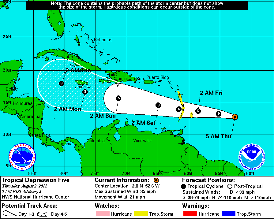
Projected track of TD 5 (Ernesto by the weekend). (NHC)
The tropics are showing signs of life again with the development of tropical depression five east of the Windward Islands. The storm has 35mph and is expected to slowly gain strength over the next 48 hours reaching tropical storm status and being named Ernesto by the weekend. Afterwards a general track towards the west northwest and Jamaica seems likely at this time.

Wednesday, August 01, 2012

August 1, 1975 - The warmest day in Montreal

Montreal, looking downtown, during the hot summer of 1975.
Montreal has never officially hit 100F. We however came very close to it on this day in 1975 when the mercury hit 37.6C or 99.7F. This is the warmest day on record in Montreal. On many occasions we have flirted with the century mark and this record over the years, most recently back on July 21, 2011 when the airport reached 35.6C. Now remember Trudeau Airport located in the Montreal suburb of Dorval, sits just inland from the chilly waters of Lac St. Louis. It is notorious for having temperatures cooler than surrounding regions, as we have seen many time just this year. Just yesterday the Airport was stuck at 29C for 5 hours while surrounding regions gained 30C easily and even above. Trudeau finally nudged up to 30.4C for a daytime high, while I recorded 32C here on L'Ile Perrot, Ottawa reached 35C and St Anicet 33C.

So one can easily argue on that hot day back in 1975 that many parts of the inner city were well above 100F, but the final word goes to Environment Canada, and the official high is 37.6C. Incidentally I was 9 years old in 1975 and we had just purchased our first pool for the backyard during that heatwave. Summer 1975 was not unusually warm but that late July early August heatwave established records that have yet to fall with a 5 day stretch of temperatures from 32 to 37.6C. If we are lucky today, and the wind is not blowing off the lake, we may make 27C (81F). It will be muggy and cloudy with more showers and perhaps a rumble of thunder.

Tuesday, July 31, 2012

25th Anniversary of Black Friday

Edmonton Journal on August 1, 1987
It was a weather day nobody in Edmonton, Alberta or Canada will ever forget. On Friday, July 31, 1987 an F-4 tornado ripped through the quiet suburbs and industrial area of east Edmonton, just skirting the heart of the city. It developed around 3pm in unusually hot and humid air near Leduc south of the city and would stay on the ground for over one hour. It obliterated everything in its path with winds of over 300 km/h. The path of destruction varied but was 40km long and up to 0.6 km (1 mile) wide. One of the hardest hit areas was the Evergreen Mobile Home Park where 200 homes were demolished and 12 lives were taken. In all the storm claimed 27 lives, injured over 600 and caused nearly one half billion dollars in damages. It would forever change warning systems in Canada and lead to improved technology and forecasting/warning techniques with Environment Canada. It was the second most deadly weather disaster in Canadian history just behind the Regina cyclone of June 30, 1912 which killed 28.

My memories of that day were disbelief that such a large and powerful tornado could occur so far north and absolute sadness at such a huge loss of life from a weather event. I had until that time believed that F-0 and F-1 were the usual strength of such storms on Canadian soil (with the exception perhaps of southern Ontario). I know better now. The tornado was an eye opener for many in the weather world as well as emergency and disaster management across the country. To this day it has changed the way we forecast these events and deliver warnings to our communities, especially in Alberta.

Monday, July 30, 2012

Warm & humid week ahead

Storm damage in Winnipeg on Sunday evening. (Photo- CBC News Manitoba)
What a beautiful weekend we had. It was a little of a surprise, as the showers and clouds remained draped across southern New England, allowing Montreal and the St. Lawrence Valley to remain in the warm sunshine with highs pushing 30C both days. The trend of warmth and sunshine will continue this week, however it will not be sunny all the time, as we are looking at an increase in humidity and a risk of showers and thunderstorms by Tuesday afternoon. This threat will continue all week with sunshine in the morning and an elevated risk of afternoon and evening showers and storms. Temperatures will be at or slightly above normal with highs between 27C and 30C (80-86F). Nights will be mild at 20C, but cooler off island with a risk of fog and dew.

It remains very dry across a large portion of North America with several regions reporting drought conditions and a section of the Midwest and southern US plains in a severe drought. Montreal is dry as well with only 90.8mm of rain for July. This is close to normal, but most of that fell in three thunderstorms. We only had rain on 8 of the 30 days in July. A watering ban remains in effect for the southwest Quebec communities of Vaudreuil/Soulanges. This includes Hudson, Valleyfield, St Lazarre and her on L'Ile Perrot. Despite this many in my own neighborhood continue to wash their cars and water their lawns. My lawn and car are both very dusty and in the case of my lawn very yellow.

It was Manitoba's turn to have the severe weather on Sunday. Strong storms swept the southern half of the province knocking down trees and utility lines and cutting power to at least 26,000. The storm also tore a roof from an apartment building in the Winnipeg suburb of North Kildonan. No injuries were reported.

Friday, July 27, 2012

A little rain & a little sunshine

The weekend is upon us once again, and just in time, really. The weather this morning has cleared out a little here in Montreal, as we sit under partly cloudy skies and 20C (68F). The humidity remains elevated but down a little from Thursday evening. We are looking at seasonable highs all weekend in the 26C range or very close to 80F. Low pressure passing off the east coast may provide the region with some instability at times over the weekend with perhaps a passing shower or rumble of thunder especially south and east of Montreal. Otherwise look for a decent weekend with more sun than clouds and temperatures right where they should be for late July in Montreal.

Thursday, July 26, 2012

Storms stay south

A spectacular photo of lightning striking the CN Tower in Toronto. This was taken early this morning by photographer Richard Gottardo.
(photo via twitter @richardgottardo)
A surface warm front draped across southwest Ontario, central New York and southern New England, will be the focus for a round of severe thunderstorms today. Overnight gusty storms swept across southern Ontario with tremendous displays of lightning across the region. All across southern Quebec and Ontario it is a muggy, humid morning. Montreal was around 22C most of the night but we have settled back to 18C with light rain. We will remain well north of the warm front today and therefore remain cooler around 24C. Toronto should see 28C. Strong storms are forecast to develop along the front and move northeast with the greatest threat for severe weather, hail and tornadoes across southern New York into Pennsylvania and the Ohio Valley. This area has a moderate risk of strong storms. Northern area of New England and southern Quebec will be north of the action with just isolated showers and a rumble of thunder through Friday.

Wednesday, July 25, 2012

Much needed rain for Ontario & Quebec

A tornado on Tuesday near Davin, Saskatchewan. (Photo by Kathy Rosenkranz)
Low pressure will travel south of the Great Lakes over the next 36 to 48 hours with a frontal wave affecting the region. We start with lots of sunshine today and warm July highs of 27C (81F), just perfect for the date. Clouds increase this evening along with showers and thunderstorms starting in southern Ontario and spreading eastward. The further southwest you go down the 401, the more rain you will encounter. A good 15-30mm is likely in Ontario, for some locations this will be the most rain all summer. Montreal and southern Quebec can expect the showers by Thursday with perhaps a rumble of thunder. The heavies rain should remain south of the border across central New York and southern Vermont. Showers will persist into Friday with unstable and humid air in place.

It was another active day in Saskatchewan on Tuesday with numerous thunderstorms flaring up in a line from Regina to Assiniboia and east to the Manitoba border. Several tornadoes were confirmed including a well developed storm near Davin, 36km east of Regina.

Environment Canada confirmed yesterday that major tree damage on Monday south of Renfrew and near Mississippi Lake, Ontario was caused by straight line winds in a micro burst reaching speeds of up to 110km/h. Damage was widespread as well as a few injuries. Here in Quebec power remains out to at least 2000 customers with crews being called back from vacation to deal with the storm damage.

Tuesday, July 24, 2012

Strong storms cool region

NIGHT BECOMES DAY: A flash of lightning illuminates my neighborhood on L'Ile Perrot at 10pm last evening. (ValleyWX Photo)
After sweltering highs in the low to mid 30's on Monday (32C here on L'Ile Perrot) a strong cold front has brought some natural A/C this morning. Strong thunderstorm activity accompanied the front as it moved from northwest to southeast across Ontario & Quebec. The first wave of storms swept east from Ottawa and into Montreal in time for the evening rush hour. This has become a very common trend this summer with traffic slowing to a crawl in heavy blinding rain and gusty winds. After a break a second and more intense line of storms swept the city from end to end at around 10pm. These storms produced vivid, prolonged lightning and strong wind gust close to 100km/h. The lightning began at my home around 9:30pm and lasted nearly two hours. The combination of the two storms brought much needed rain to southern Quebec with 27mm at Trudeau Airport and 41.2mm here on L'Ile Perrot. They also knocked down trees and power lines from Eastern Ontario across the Island of Montreal keeping city firefighters responding to dozens of calls. Also taking a hit was the electrical grid with 10,000 losing power in Ottawa and 80,000 in Quebec including about 20,000 home in metro Montreal. Of that, Hydro Quebec reports about 50 per cent has since been restored. It will be a cooler and drier day today with clouds and sun and just a slight chance of a passing shower. Temperatures will be cooler at 24C (76F).

DAY BECOMES NIGHT: Dark clouds turn 3pm into late evening darkness in Merrickville, Ontario on Monday afternoon. Trees were down and power was out in many eastern Ontario towns. (Photo Maggie LB)
 A wide area of the country was affected by severe weather on Monday. At one point about 7% of the Canadian population was under a tornado watch or warning. Alberta was hard hit with heavy rain and strong winds as well as isolated tornadoes. More tornadoes were also reported in Saskatchewan. More severe weather is likely  today in western Canada, while the threat here in the east has slipped south into southern New England and the Middle Atlantic states.

Monday, July 23, 2012

Severe thunderstorms likley today in Ontario & Quebec

Tornado damage from Saturday near Smeaton, Sask, northeast of Prince Albert. (CJME Website)
SEVERE THUNDERSTORM WATCH - METRO MONTREAL & WEST QUEBEC

In a scenario that has played out frequently in southern Canada this summer, we are looking at the threat for severe weather across a wide area once again today. A strong jet stream over southern Canada and a large dome of hot air and drought conditions over the US is pushing lots of severe weather well north of where it should be and into our regions. The number of tornado warnings this summer in Saskatchewan, all the Prairies, Ontario and southern Quebec is unreal. More tornadoes were reported in Saskatchewan on Saturday with one smashing into a farm and destroying a house in Smeaton. There were reports of large hail and strong winds over 110km/h in southeast Saskatchewan. Meanwhile local thunderstorms produced as much as 80mm of rain near Hamilton with flooding reported. Last eveing isolated strong storms occured in the Ottawa Valley northwest of Montreal.

Here in Montreal we had a warm and humid weekend with highs near 31C and overnight lows well into the 20's. It is already 24C (76F) at my home here on L'Ile Perrot with elevated humidity and dew point readings. A warm day is on tap with temperatures near 32C (90F) region wide. This combined with the humidity will push heat index values to near 40C. The heat will come to an abrupt end this afternoon and evening as a potent cold front settles southeast across the St. Lawrence Valley. There is a risk of strong to severe storms in southern Quebec and from Ottawa southwest towards Toronto beginning late this afternoon and lasting until midnight. Heavy rain, in excess of 30mm, gusty winds and large hail are possible. There is even the risk of an isolated tornado. The threat will slip southeast across the Townships and into northern Vermont and New York by evening.

I will update all watches and warnings for the region today via the Twitter feed on the upper left side of this blog.

Friday, July 20, 2012

Weekend weather update

After a rather active weather week across many areas of the country we can expect a quiet and pleasent weekend. High pressure will continue to build across southern Quebec with sunshine today and most of the weekend along with normal temperatures for July. Highs will range from 25 to 28C with lows generally from 12 to 16C. There is a slight chance of showers and perhaps some thunder late Sunday and again on Monday as the humidity begins to creep up once again. Next week at this time looks warm but not oppressively hot, and dry most of the time. The intense heat will remain south of a front, locked into the US Midwest and deep south.

Thursday, July 19, 2012

Ontario & Saskatchewan tornadoes

Environment Canada has confirmed two tornadoes touched down during Tuesday afternoons severe weather outbreak in Ontario and Quebec. The first tornado occurred at 1:45pm east of Cornwall in tiny Seaway community of Summerstown. The storm destroyed several tees and carved an area of damage 30 metres wide by 2km long. It was rated as an F-0 on the Enhanced Fujita Scale with estimated winds of 110km/h. The second tornado occurred around 3:30pm near Athens, Ontario north of Brockville. The storm was much larger at 300 metres wide and travelling 3km on the ground. This storm was estimated at F-1 strength with winds up to 140km/h possible. There have been 5 tornadoes reported in Ontario this season, normally 13 occur. No tornadoes have been confirmed in southern Quebec, however rotation was observed in several storm cells, including the one I photographed over Pointe Claire and numerous tornado warnings were issued.

From Greg Johnson at TornadoHunter.ca, just an awesome picture of one of yesterday's storms. This tornado was captured near Wadena, Saskatchewan.
Yesterday was another wild storm chasing day on the Prairies. Hot and unusually humid air was in place and three more tornadoes were reported. Saskatchewan has had an active year with nearly 2 dozen tornadoes reported. Thankfully there were no injuries reported in this latest outbreak. It remains warm and humid across southeast Saskatchewan today so the threat remains for more storms. Check out storm chaser Greg Johnson at tornadohunter.ca well worth the visit.