Wednesday, March 20, 2013

A serious setback to Spring 2013 in Montreal

BBQ season is temporarily on hold. ValleyWX

Plowing in Montreal on Tuesday.

Photograph by: Marie-France Coallier, The Gazette

Spring arrived at 7:02am this morning, took one look around Montreal and left. What a winter 2012/2013 has turned out to be. Already this winter we managed to beat the 1971 daily record and now we have just had a top 5 March storm on the very last day of winter. The snow started early yesterday morning and when all was said and done in the wee hours of this morning, between 33 and 40cm (13-16 inches) of snow had fallen across the Montreal metro area. I measured 33cm at 6pm yesterday (photo on the left) here on L'Ile Perrot and another 3-5cm has fallen overnight. Light snow continues this morning with cold temperatures around -6C. Light precipitation will prevail for the next couple of days as a result of a blocking pattern over the north Atlantic with temperatures below normal around -1C. Any snow accumulations will be light with just 1-3cm expected over the next 24 hours.

One factor that may become a problem for area highways on Thursday, is an increase in the wind. Gusts of to 50km/h are possible on Thursday and this could cause all the snow to start blowing around. We will have to see how that develops. In the meantime spring is on hold as we have mountains and mountains of snow across the city, and we need to have some serious melting! Oh by the way, one year ago today Montreal recorded one of  its warmest March temperatures on record as the mercury soared to 24C (76F).

Tuesday, March 19, 2013

Second biggest storm of the season for Montreal

A slow morning commute in Montreal. (ValleyWX Photo)
Trudeau Airport is approaching 30cm (1 foot) of snow this afternoon as the second biggest storm of the season begins to ease its grip on the region. Another shot of snow is moving northeast from Ontario but is should only give another 5cm or so to the city. Storm totals will settle into the 30-40cm range across southern Quebec. This makes it the snowiest March 19 on record smashing the previous amount of 11.7cm set in 1952. As mentioned it is also the second biggest storm for the city this winter, eclipsed only by the December 27th storm. The storm caused hundreds of accidents, closed schools and cancelled flights. Conditions will slowly improve tonight across the region as the heavy snow moves into eastern New England and Atlantic Canada. Temperatures are around -1C but will cool to -6C tonight.

The cleanup begins. (ValleyWX Photo)

Winter storm affecting Quebec

The forecast... sunny and 21C, oh wait that was last year! No record warmth this March.
This year: snow & blowing snow, very poor travel, delays and cancellations at Trudeau Airport and a pile of school closings including the Lester B Pearson School Board and the Townships Board among others.

Highway 40 on the West Island this morning - snow covered and windy.
The actual forecast has winter storm warnings posted from Cornwall to Quebec City, south and east into New York and New England. A decent amount of snow has fallen on L'Ile Perrot overnight with between 5 and 10cm on the ground. Another 10-15cm or up to 6 inches more is likely by the time the storm tapers off early Wednesday. Gusty northeast winds are blowing the snow around the valley this morning. It will be slow going no matter where you are heading today with roads snow covered and visibility low. Temperatures will be in the 0 to -3C range across the area for highs.


Low pressure over Michigan has pushed a warm front just south of Montreal that is the focus for the snow at this time. That precipitation will taper off as a second low pressure area begins to develop along the Atlantic Coast. That storm will move towards Cape Cod today. It will send more moisture north later today with perhaps another 5cm for Montreal overnight. Storm totals will fall into the 20-30cm range from Montreal south with over 30cm possible in Vermont.

Monday, March 18, 2013

Winter storm update

Major late season winter storm still on track. Winter storm warnings remain posted for all of southwestern Quebec and extreme eastern Ontario. They are also in effect for all of New York and Vermont as well as most of New England. The leading edge of the snow is moving northeast across eastern Ontario and central New York towards Quebec at this hour with snow expected by 3 or 4am in Montreal. It will start light but become rather heavy towards the morning commute. Gusty northeast winds up to 50km/h will cause blowing snow. The snow will become light through the midday hours on Tuesday while a second area of low pressure begins to develop off the east coast near Delaware. Once this system begins to migrate towards Cape Cod, snow will once again become steady and heavy at times into Tuesday night. Total storm accumulations will range from 20 to 30cm in the St. Lawrence Valley and up to 50cm in the Townships and  across Vermont and New Hampshire. Temperatures will be cold for March around -2C with gusty winds.

Winter Storm Warning for Montreal

Yes you are seeing right! Last years record high of 23C on this day is being replaced by a winter storm warning for this year. (AccuWeather)
The high temperature in Montreal one year ago today was 23C (73F), that would be followed by an all time March record high of 25.8C (79F) on the 21st. Well not this year, it is a cold morning by any standards here on L'Ile Perrot as we sit at -15C (7F), two days before spring arrives, and we have a big storm on the way.

Sunshine today will slip away to increasing clouds as we have a major winter storm heading for Ontario and Quebec. A winter storm warning has been issued for southwest Quebec, as well as the Champlain Valley and Adirondacks of New York and the Green Mountains of Vermont. Warnings will likely be needed as well for eastern Ontario east of the 416 later today. The storm will come in two distinct waves. The first will come from low pressure moving from Minnesota to Michigan. This system will push a warm front just south of the St. Lawrence Valley late today with snow accumulating to 10cm from about 3am in Montreal on Tuesday to mid morning  It will be accompanied by gusty northeast winds. Meanwhile a second area of low pressure will develop near Delaware and move towards Boston. This will become the main storm as it deepens rapidly. Heavy snow will once again overspread the region this time from the southeast by late in the day Tuesday and fall at the rate of 2-4cm an hour for a time. Once the snow ends on Wednesday most areas will have received 25cm (10 inches) of wet snow. Areas in the Townships and along the US border could have as much as 35cm (14 inches). Strong winds will create poor visibility especially south and east of Montreal. It will remain cold with highs near 0C (32F) and lows down to -6C during the storm. These temperatures are well below normal for March. Expect travel delays on the ground and in the air starting late today across southern Ontario.

Sunday, March 17, 2013

Winter won't leave Montreal alone

The carnage left behind after brief snow squalls caused a 20 care pileup on the 401 near Prescott, Ontario on Friday afternoon.
Late season snowstorm on the way for Ontario & Quebec
Sorry for the lack of updates lately but I have been a little "under the weather." Many of us here in Ontario and Quebec are, as we have just had it with a winter that won't go away. As I write this blog this morning it is -9C outside my house, more typical of January not 3 days before Spring arrives. The high today will only be -5C, the normal should be plus 3C. We had several snow squalls move across eastern Ontario, southern Quebec and Vermont on Friday afternoon. The combination of brief heavy snow and strong winds created multiple major accidents across the region. The biggest closed down the 401 at Prescott, Ontario for over 15 hours after 20 vehicles were involved. Several injuries were reported, two critical in  nature. This perhaps was just a sample of what lies ahead this week.

Another big snowfall is on the way for New England, Quebec and eastern Ontario. Two low pressure areas one over the northern plains, and the second forecast to develop Monday off the Delaware coast, are forecast to move towards the region. This will be a complex system as they all have been this winter. Look for a heavy wet snow to develop late Monday and last into Wednesday morning. At this time we are looking at perhaps 20cm of snow for the region. There is the potential of even more if the second system turns out to be stronger. There are lots of details to work out, but for the time being, expect wet snow and poor travel on Tuesday. One thing is certain it will be snow as cold air and below normal temperatures are here for the week ahead.

Thursday, March 14, 2013

Wind & cold - the return of winter

Just in case you thought winter was over, you need only step outside this morning to realize it is not. Temperatures are the coldest they have been this month with current readings at -6C (windchill -13C). Add to that a biting northwest wind in the 30-50km/h range and some light snow and it feels like mid January. About 1cm of snow fell in a few squalls during the overnight hours, they are just about done, but the cold is here for the day. We are currently looking at our high temperature for the day with little or no movement. Lows tonight will be around -10C. It is currently -11C in Ottawa and they also are expecting a cold day today. Looking ahead we have some light snow and chilly temperatures to end the week on Friday followed by a sunny and seasonable weekend with highs close to the freezing point both days. On Monday low pressure will be developing in the central plains and moving towards the Great Lakes. Current indications are for a rain /snow mix. Depending on the exact track it could be more than 10cm of wet snow on Tuesday for some regions. That is several days away, so lets first deal with the wind and cold today.

On a final note we have had about 22.6mm of rain here on L'Ile Perrot so far this month. This in combination with the warmer temperatures has really began to melt the snow pack. There are still lots of big dirty piles of snow around but we are heading in the right direction!

Tuesday, March 12, 2013

Rainy & mild day for Montreal

We remain on the mild side of a slow moving cold front this morning with temperatures near 6C in Montreal. Low pressure continues to move northeast well to the north of Montreal with the cold front expected to clear the region today. Ahead of it we had about 6mm of rain overnight on L'Ile Perrot but radar is showing more steady rain to our southwest lifting towards eastern Ontario and southern Quebec. It should be a rainy day with temperatures fairly steady across southern Quebec between 5 and 8C. Expect about another 10mm or so in Montreal but much more along the US border where rainfall warnings are in effect. Those locations including Sherbrooke could see an additional 25-35mm of rain. Further to our south in Vermont and east central New York heavy rain is also forecast with a flood watch posted for those locations. The combination of up to 1 inch of rain, snow melt and moving river ice could lead to sharp rises on area waterways. Another point to take note of for all regions is to stay off and away from river ice which has begun to melt here is the south and has become very unstable.

Storm next week?
Cooler air will move into the region tonight behind the front with lows dropping to -2C and any rain tapering off to a brief period of wet snow. The balance of the week looks unsettled and much cooler with flurries possible. A weak clipper system may bring a few centimetres of snow for Saturday. Another storm is poised to affect the region early next week. This far out amounts and type of precipitation is too difficult to pinpoint, but it may be snow for some of us.

Monday, March 11, 2013

The fifth season...mud!

There is little in the way of snow cover in Lennoxville, QC in the Townships, with just puddles and mud left.
The fifth season is upon us, known affectionately in Vermont and parts of southern Quebec, as the mud season. I was down in Sherbrooke yesterday, and with the 11C high, there was lots of melting snow, mud and dirt. It is not a pretty time of year, and some areas will progress through it quicker than others. I noticed quite a bit less snow in the Sherbrooke area as they were spared the more intense storms this winter. My neighborhood on the other hand is looking at several weeks yet of melting snow and ice. We were spared this season last year with limited snow cover and a very early and downright hot spring. This will not be the case this year with a more traditional March expected.

The temperatures today and tomorrow along with perhaps 15-25mm of rain in eastern Ontario and southern Quebec will certainly help with the melting process. We start the day at a mild 3C (38F) here on L'Ile Perrot. It is dry for the moment, but low pressure lifting north in the central Great Lakes will drag a cold front across the St. Lawrence Valley overnight tonight. Ahead of the front today we can expect a few showers with gusty southwest winds developing up to 50km/h at times later today. Rain will start this evening and continue all day Tuesday tapering off to drizzle or perhaps a few mountain flurries by late in the day. Temperatures will be very mild in the 7C (45F) range both days, and dropping only down to 3 or 4C tonight. The balance of the work week looks cloudy and cooler with temperatures dropping back below freezing and perhaps a few snow showers.

A house rests at an unnatural angle on Plum Island, Massachusetts after another coastal storm pounded the region. In all 12 homes have been deemed to dangerous to occupy.
 Plum Island, Mass
My vacation the last couple of years has been closer to home in the New England region rather than North Carolina. I discovered a barrier island off the northeast coast of Massachusetts that I just love, reminds me a little of the Outer Banks. It has unfortunately, like all east coast barrier islands, taken a beating this past year. First hurricane Sandy and now back to back Nor'Easters have pounded the beach with high surf. The result has been severe beach erosion which led to a couple of homes collapsing into the surf this past weekend. In all 12 homes are too dangerous to occupy at this time. Plum Island is experiencing what so many coastal communities up and down the east coast have been since last September.

Thursday, March 07, 2013

Storm pounds Eastern Seaboard

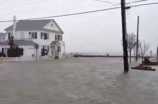
Coastal flooding from Wednesday's Nor' Easter in Ocean City, Maryland.
The same areas of the US Eastern Seaboard that have taken a beating since Hurricane Sandy were once again hit on Wednesday. As expected low pressure moved off the Atlantic coast near Virginia Beach and slowly began moving into the north Atlantic. This system produced heavy wet snow, in the order of 1 to 2 feet across West Virginia and Maryland but for the most part spared the large cities of the east coast. The big weather story with this storm has been the wind and waves. Coastal flooding has been reported from the Outer Banks to Cape Cod. Both the Eastern Shore and portions of New Jersey have been hit  hard again with water inundating coastal roads and properties. The Coast Guard is searching for two missing fisherman from North Carolina who went missing in the 15 foot seas off Assateague Island, Virginia. Three were on board and one has since been rescued. The search will resume at first light this morning in continuing rough seas and 50mph winds. Power was knocked out to thousands in the middle Atlantic region.

Huge waves pound the coast in Virginia Beach near the Chesapeake Bay Bridge Tunnel.  The 26 mile bridge connecting the Eastern Shore to the mainland was closed to all traffic on Wednesday. (WAVY 10)
Locally across southern Quebec the storm has produced nothing but clouds and gusty northeast winds. Today a trough from the Great Lakes will draw some moisture northwest form the edge of the system and produce some flurries over the St. Lawrence Valley with perhaps a couple of inches of wet snow over Vermont. Skies will clear for Friday with a fair and mild weekend before storminess returns for next week.

Wednesday, March 06, 2013

Big snowstorm stays south

The bulk of the snow will remain south and east of the border with just a few flurries or showers nudging into southern Ontario and Quebec. Winds will be gusty in the St. Lawrence Valley, up to 50km/h due to the storm. (AccuWeather)
The same blocking features in the north Atlantic that have kept the clouds and light precipitation over southern Quebec are now sparring us the big Midwestern snowstorm. The system has taken a path from the southern Prairies across the upper Midwest and into the middle Atlantic this morning. A rash of warnings are in effect from Virginia and the Outer Banks north into New England. The storm has already put down 10 inches of heavy wet snow in western Maryland, and some areas into West Virginia could see up to 2 feet. Snow will spread across the coastal plain and north towards Boston by evening  Over 6 inches of snow could accumulate in Baltimore and Washington. Rain will mix in along the coast. The other factor with this storm will be wind and surge. Coastal flood warnings are up along the battered New Jersey and New England coastlines this morning. Surge flooding is likely over the next 24 to 36 hours as the system moves into the open waters of the Atlantic and intensifies sending a northeast fetch of wind and water into the coast.

Montreal will remain on the northern edge of the system with clouds and perhaps a stray snowflake or two. Winds will be gusty, but temperatures should be mild to end the week up to plus 2 or 3C. The weekend at this time looks sunny and mild, maybe up to 7C (45F) in the warm March sun, before cooler weather and perhaps some snow return for next week.

Tuesday, March 05, 2013

When will winter end?

A fierce blizzard closed highways in and around Regina and other parts of the Prairies on Sunday and Monday. (National Post)
Another March morning, another cold and windy one with more snow. The winter of 2012-2013 does not seem to want to end, and the mounds of snow, including the 2 or 3cm that fell overnight here on L'Ile Perrot, are a testament to that. The temperature currently is -5C but with windchill values below -10C. We are expecting low pressure in the north Atlantic to finally release its grip on the region today and allow for milder temperatures and perhaps a few breaks.

This clearing will be short lived as another massive storm system begins to move into the middle Atlantic from the Midwest. This storm will give Montreal gusty northeast winds and perhaps clouds but no precipitation on Wednesday. The snow and rain with this storm will slide south of the region. This system was responsible for a big blizzard across portions of all three Prairie provinces from Sunday into late Monday  Many roads were closed and travelers stranded for hours. Between 25 and 40cm of snow was blown around by fierce 100km/h winds. The storm is moving into the upper Midwest today and is expected to move to the middle Atlantic by Thursday. It will then redevelop off the east coast and become a big weather story for the Atlantic coast with pounding surf for days.

The North Atlantic remains blocked which basically is not allowing weather systems to easily move east. This will keep temperatures in southern Quebec and eastern Canada below normal into the middle portion of March with perhaps more snow than normal. One good thing about a cooler March is that this will hopefully allow for a slow snow melt. Last March we had several record highs as the mercury soared to near 25C (77F).

Sunday, March 03, 2013

March 3-5, 1971 vs December 2012 in Montreal

Remembering 1971
Today is the 42nd anniversary of the start of the great Montreal blizzard of 1971. I have written plenty in the past about this particular day and what it means to me from a personal perspective. You can read what I wrote on the 39th anniversary by clicking on the red link above.
Above: The struggle to get home begins on March 4, 1971. The blizzard of 1971 dumped 43cm of snow on Montreal in under 24 hours with hurricane force winds and 6 foot drifts all over the province. Over 50cm fell during the 2 day storm. Nearly 20 fatalities occurred as a result of the storm. Roads were closed and thousands stranded downtown. Power was out for days in many parts of the province.
(Photo from fredericks-artworks.blogspot.ca)
What I will mention today is what long time CJAD traffic reporter Rick Leckner had to say on the morning after we broke the 1971 record this past December 27, 2012. He noted that the only comparison between 1971 and 2012 were in the quantities of snow, 45cm (2012) in 24 hours vs 43cm (1971). The comparison stopped there. On the morning after the big storm, March 5, 1971 he took the CJAD 800 helicopter up for a look at the carnage left on Montreal and southern Quebec highways. What he saw was abandoned cars everywhere and one lane down the center of most highways, nothing more. There were huge drifts of snow blocking highways all over the city. On the morning after this past December's storm, people were travelling to work on black top at 100km/h with no delays to speak of. The 1971 storm stands alone, we have yet to match it, I will let you know if and when we do. The only storm that came close was the March 13, 1993 east coast super storm, but it happened on a weekend lessening the impact.

We are approaching the 20th anniversary of that storm, I will have much more to say on that in a later entry.
You can also read what I wrote for the 40th anniversary of the 71 blizzard HERE

Thursday, February 28, 2013

Snowy morning in Montreal

The Davis Vantage Vue in my backyard continues to preform despite the heavy wet snow on top of.
Low pressure continues to meander near Lake Ontario in upstate New York this morning with the main area of snow starting to weaken and move northwest of the greater Montreal region. The light snow falling this morning across the St. Lawrence Valley should end by noon with just a few flurries or showers into the afternoon. I measured around 15cm of heavy, hard packed wet snow on my driveway. This stuff is heart attack snow, I moved just a few shovels of it and opted for the snow blower later this evening.

The snow is wet in nature and has stuck to everything making for a beautiful landscape this morning. (ValleyWX)
Trudeau Airport measured about 16cm yesterday in addition to what fell overnight. I am thinking most of the Ottawa Valley into Montreal will end up with close to 20cm (8 inches) for this event. The low pressure will be very stubborn to move out with weather systems being blocked by Atlantic high pressure. So expect clouds and light precipitation well into the weekend. We could pick up another 2-4cm of snow over that time frame. Temperatures will remain mild, with little in the way of diurnal range, highs generally 0 to 2C lows -1 to -3C.

Wednesday, February 27, 2013

Heavy wet snow in Montreal


The snowfall warning remains in effect as wet snow continues to fall across southern Quebec and into eastern Ontario. Gusty winds up to 50km/h are making for a raw night outdoors. As of 9pm about 10cm (4 inches) has fallen here on L'Ile Perrot since about 3pm. Prior to that is was just too mild and the snow was melting on contact. Snow will continue overnight, mostly light, but with pockets of heavier snow, especially across eastern Ontario. Temperatures will remain steady near 0C.

The winter that won't end

Wind and snow attacked this tree in the Toronto area overnight.
(Via twitter @vaughanweather)
SNOWFALL WARNING: Metro Montreal
Radar this morning is showing decent precipitation moving north into southern Quebec from twin low pressure areas. We have most locations reporting a mix of rain to snow with pockets of heavy wet snow. The strongest returns and heaviest precipitation at this time is falling over St. Lawrence County, NY moving north into eastern Ontario. This will be affecting the 416 corridor over the next several hours with heavy wet snow north into Ottawa. Montreal can expect light precipitation to begin shortly with rain at the onset switching over to snow. Temperatures will be near the 0C mark for the next 24 hours making this a difficult forecast. A spattering of warnings are in effect including a snowfall warning for metro Montreal. Amounts will be widely variable and range from 5cm up to 20cm (2-8 inches) depending on location and elevation. Winds will be a factor gusting up to 60km/h out of the northeast.

Overnight snow and rain has caused travel issues across southern Ontario and in the GTA. There are numerous accidents as well gusty winds have brought down some trees and power lines. The travel delays are not reserved to the road with VIA Rail reporting 20 minute delays or more in the Montreal to Toronto corridor as well as 20 percent of the flights cancelled or delayed at Pearson Airport.

Radar at 7:15 am showing two main zones of precipitation from the two storms, with a dry slot between. A very difficult call for snow totals.
Low pressure areas will slowly move north today, one over Ohio, the second off the mid-Atlantic coast. Look for precipitation all day into the overnight for southern Quebec. Most time it will be light but there will be heavier bands within the system.

Tuesday, February 26, 2013

Difficult stormy forecast

Interstate 29 in Kansas City on Monday as heavy wet snow and strong winds disrupted travel. (AP Photo)
One thing is certain about the upcoming storm, there will be one. The question will be, who gets rain and who gets snow? Today, the calm before the storm, we have ice fog this morning with visibility down to 0.4km at Trudeau. That should lift shortly with a mild, partly sunny day and high temperatures near 2C. It will be mild tonight with lows down to -3C. Mild again on Wednesday as the storm starts with highs near 1C.

As far as the storm goes, a betting man would say snow north of Montreal, mix in the city and rain south and east of the metro region. It looks like Ottawa will have all snow with over 15cm possible, same goes for the Laurentians. Burlington, Vermont west towards Cornwall and points south, mostly rain with perhaps a few inches of slushy snow. The big question mark will be here in Montreal and in general the St. Lawrence Valley. Northeast winds can often keep temperatures just cold enough at the surface for snow or freezing rain, especially in this type of a scenario. The wind will be out of the east at 40-60km/h. The official word from Environment Canada is 5cm of snow mixed with rain on Wednesday, with wet snow Thursday as cooler air is drawn back into the system. My thoughts are that it will be mostly a snow event with over 15cm likely. As I always say, time will tell.

This storm originates from Texas and is bringing north a tremendous amount of moisture. Yesterday blizzard conditions were reported from north Texas into the central Plains and Midwest. Some areas had over 40cm of snow, and hurricane force winds were reported in Amarillo, Texas with the snow. Meanwhile strong thunderstorms produced hail and damaging winds along the Gulf Coast from Louisiana to Florida. This storm has the potential to disrupt travel on Wednesday and Thursday on the busy Montreal to Windsor corridor.

Monday, February 25, 2013

Another storm for Ontario & Quebec

Montreal had nearly 10cm of wet snow that made travel a little tricky on Saturday. (ValleyWX)
Montreal enjoyed a mild weekend with wet snow off and on for most of it, and very little sunshine. Trudeau Airport had about 8cm of steady wet snow on Saturday, that was quite heavy at times. This morning it remains mild at -1C, but just cold enough for a layer of thin ice beneath the dusting of snow. We should see a few breaks in the cloud today as high pressure attempts to briefly build into the region. It will be short lived as a rather large and very complex storm is taking shape over Texas. This system will lift north towards the Great Lakes over the next several days and dominate our weather from late Tuesday until the end of the week. Today and Tuesday will be quiet in southern Quebec with mild late February highs of 1 to 3C and just a few flurries this morning.

By late Tuesday deep moisture will begin to surge across Ontario and Quebec from the Texas storm. It appears precipitation will fall as wet snow mixed with rain for most locations. Amounts will be very tricky to forecast with just enough warm air to mix the snow with rain in many locations. Specific amounts, type and duration of precipitation will be further complicated by a second storm that develops along the US east coast. Both system will provide the region with precipitation well into Thursday. At this time it looks like at least 15cm for Montreal and maybe more. Warnings may be required for a large portions of the region from Ontario into Quebec, Atlantic Canada and northern New York and New England. Winds will be gusty with the system especially along Lake Ontario and the St. Lawrence Valley.

Friday, February 22, 2013

More precipitation for snow weary Quebec

I need spring!
With March just around the corner, it appears we are well entrenched in winter 2012-2013. The wind has finally eased this morning after 48 hours of blowing snow, making me think I was back in Saskatchewan. Drifts are 2 and 3 feet high in open spaces with snowbanks towering over residential streets.The blowing snow was a nuisance in the city but very problematic on area highways, especially the 20 west to the Ontario border and the 15 and 30 on the south shore. Final accumulations from the two day event ranged from near 20cm (8 inches) in metro Montreal up to 40cm across the Townships and 60-100cm in the Gaspe region and eastern Quebec. This morning it is calm and rather mild compared to Thursday morning with a temperature of -6C. Today will be sunny and calm with mild highs of 0C (32F).

Snow blown by 60km/h west winds continued on Thursday afternoon on the West Island of Montreal.
We now await the next storm system moving from the central US plains into the Great Lakes. This storm is very strong bringing blizzard conditions across Kansas and Nebraska. It is however expected to weaken while a second system develops along the US east coast and moves well east of Cape Cod. Both storms will be far enough from Montreal as to not produce a major storm. However we are looking at snow developing Saturday and lasting into Sunday with 5-10cm (2-4 inches) expected, perhaps more once again across the south shore. It  will be breezy, but not like the intense wind we just had, perhaps in the 20-40km/h range. Temperature will be mild, so the snow will be wet, also cutting down on the blowing and drifting. More snow is expected next week as yet another storm heads towards the northeast.

Thursday, February 21, 2013

Over 100cm snow in the Gaspe

Spring is out there somewhere, but it does not look like it on L'Ile Perrot with the mountains of snow in my neighborhood. I have not seen my lawn since early December. We are buried and if it was not for the two major January thaws we would have even more. (ValleyWX Photos)
This is not a storm, right? At least that is what I blogged yesterday, but it sure feels like one. Low pressure near Sydney, Nova Scotia, continues to pinwheel waves of snow across southwestern Quebec. Most times the snow has been light but often it is not. The result has been 15-20cm (6-8 inches) across most metro regions with over 30cm in the Townships and Green Mountains of Vermont. Officially Trudeau Airport had 11cm yesterday  but with the west wind gusting over 60km/h it has been difficult to measure at best. It looks like 15cm here on L'Ile Perrot, but I have drifts in the backyard over 2 feet. The wind has been relentless for the last 24 hours with blowing snow creating havoc on south shore highways, including the new Autoroute 30 that had to be closed in sections yesterday due to whiteout conditions. This morning there have already been several major accidents on area highways as the wind and blowing snow continue, now with biting cold at -14C (6F) and windchills down in the minus 20's in Montreal.

100cm of snow in the Gaspe
Other parts of the province have been hit much harder, with over 100cm (40 inches) of snow from back to back storms across the Gaspe region. Strong winds have whipped the snow into to high drifts closing many roads. The Gaspe Airport has had visibility under 0.5km since last evening. They recorded 27cm of snow yesterday, to go with the 60cm already this week. There is relief in sight as the low pressure will move into the north Atlantic and release its grip on the area. Skies will clear out for Friday and it will be fair and warmer, up to 0C in the bright late February sun. More stormy weather is expected this weekend with rain and snow. More on that later today.

Wednesday, February 20, 2013

Snowy week for Montreal

A burst of moderate snow on L'Ile Perrot last night left about 8cm on the ground. (ValleyWX)
While it is not a storm as such, there will be enough snow to shovel and plow over the next few days across southern Ontario and Quebec. A trough of low pressure swung across southern Quebec last night with a surprising burst of moderate snow between 7:30pm and around 11pm. Some locations reported as much as 8cm with 6cm officially at Trudeau Airport. That amounts to 2 or 3 inches in just a few hours. This morning the gusty northwest winds are blowing that snow around and they will continue most of the day up to 60km/h.

A large upper level low will slowly drift across eastern Ontario and southern Quebec well into Friday with periods of snow. The snow will be light most of the time with amounts in the 5-10cm range by late Thursday with higher totals across the snow belts of the Great Lakes and in the mountains north and southeast of Montreal. Friday looks fair at this time before another low and frontal system approaches the St. Lawrence Valley for Saturday. Temperatures will be slightly cooler today around -3C but warm to the freezing point for the balance of the week. Overnight lows will generally be mild around -5C.

Tuesday, February 19, 2013

Light to moderate snowfall for Ontario & Quebec

The power is coming back on in Atlantic Canada after a winter storm walloped the region with winds in excess of 100km/h and over 30cm of snow on Sunday and Monday. Heavy rain and high surf affected  Nova Scotia. Search efforts also continue for the Miss Ally, a 13 metre fishing boat that went missing during the height of the storm late Sunday off the Nova Scotia coast with 5 on board. (CBC)
A series of low pressure areas will bring a mixed bag of winter weather to portions of Ontario and Quebec over the next few days. Today we have low pressure lifting northeast across the central Great Lakes and into Ontario. This system will push a warm front up the St. Lawrence Valley later today with light snow spreading into eastern Ontario and Montreal by late today. The snow will continue overnight and mix with some rain or freezing rain along the US border. Temperatures will warm to near the freezing point in southern Quebec and above south of the border into New York and west into the GTA. Snowfall amounts will range from a trace near the US border to around 5cm in Montreal and as much as 10cm north and west of the city. A strong cold front will cross Ontario today and into Quebec by Wednesday with gusty winds, up to 90km/h in Ontario and 60km/h in southern Quebec. Some decent snow showers are expected along the front with blowing snow and perhaps another couple of centimeters accumulation. Temperatures will cool off behind the front with highs of -3C on Wednesday. The balance of the week looks unsettled with more snow flurries and temperatures close to the normal high of  -3C.

Sunday, February 17, 2013

Atlantic Canada & Gaspe snowstorm update

Here is an update on the current snowstorm affecting Atlantic Canada, along with a great satellite photo of the storm. Montreal is on the western edge of the system with just some high clouds to the east, we will however have gusty winds up to 60km/h. Combine that with overnight lows of -16C, and windchill values will be as cold as -29C for the morning commute on Monday.

Snowstorm Update - Canadian Weather Blog Weather Blog

Friday, February 15, 2013

Snowstorm for eastern Quebec

Light snow is falling across eastern portions of the island of Montreal this morning as a clipper system races off to the east. L'Ile Perrot had around 2cm overnight, most of that falling in a burst just before 6am. Local roads are slippery but temperatures are very mild, right at 0C (32F), so melting is occurring on the main highways. Skies will be cloudy for the most part today as winds increase out of the west and temperatures level off or slowly fall. Tonight should be clear and cooler than it has been across the region with lows on either side of -10C. The weekend for the Montreal metro region and points west looks great with lots of sunshine, but chilly. Off to the east and southeast it will be a different story as a coastal low takes shape and moves northeast towards Atlantic Canada. This storm will be well offshore so I don't expect anything for Montreal on Sunday at this time, except a passing cloud or two. Some light snow is forecast across New England, but amounts will be light. The heaviest snow and strongest winds will occur in eastern Quebec and across New Brunswick where up to 20cm is possible.

HYDRO-QUEBEC
Last weekends snowstorm in New England prompted Hydro-Quebec to send 50 crews to Massachusetts to help restore power to more than 600,000 homes and businesses. There is always so much negative attention given to the province of Quebec in the media. Yesterday this brief note was published in the Montreal Gazette, so I though I would share it here. These guys work long hours in difficult and dangerous conditions to keep the power on. Kudos to them, nice job.


As a resident of Wareham, Massachusetts, U.S.A., I would like to extend my sincere thanks for all the help Hydro-Québec crews gave us during our blizzard and severe electrical outage this past weekend! What a great feeling it is to know that we can all come together across borders and cultures to help one another. Your crews were very professional and you were well represented. It’s something me and my family will not soon forget!
Christopher Childress Sr
Wareham, Mass.

Wednesday, February 13, 2013

Mild with flurries for Ontario & Quebec

Weak high pressure will try to clear skies out today but I think low clouds and moisture will limit any sunshine we see here in southern Quebec. On Tuesday and overnight we had periods of very light snow with a trace to as much as 1cm here on L'Ile Perrot. It is mild with the cloud cover keeping the temperatures in the -2C range. Highs today will be up above freezing to 2C. Thursday will be partly cloudy and a touch cooler with highs generally below freezing at -1C. By Friday another clipper system will affect southern Ontario and Quebec with some light snow and rain. As a rule these type of systems produce up to 5cm of snow or rain and not much more. The weekend at this time looks fair with near normal temperatures, but we are watching the potential for another east coast storm once again by Sunday. This will need to be monitored as several scenarios are at play at the moment. The system could hug the coast or move well out into the Atlantic and miss us entirely.

Tuesday, February 12, 2013

Unsettled weather week ahead

Another photo from the big blizzard of 2013. This was taken in Digby, Nova Scotia. (CTV News)
The freezing rain and rain are over for the Montreal area as low pressure continues to move well north and east of the city this morning. Yesterday, cold air hung around longer than expected in the St. Lawrence Valley and as a result we had several hours of freezing rain late in the day. Conditions on the Island of Montreal were icy but not as bad as off island highways. Highway 30 across the south shore in Beauharnois was the scene of several ditched cars during the evening rush hour. Temperatures finally did warm above freezing late in the evening, all the way up to 4C, the first above zero reading this month. We are still above the freezing point at 1C (33F) this morning with several snow flurries around. There are some heavier snow showers in the Ottawa Valley along an advancing cold front, so we may see 1-2cm today. Some heavier snow will be confined to the higher elevations of the Green Mountains and the Townships as well as the snowbelt region along Interstate 81 east of Lake Ontario.

Temperatures will stay right where they are all day. Under partly cloudy skies lows will be around -10C and up to -1C on Wednesday. Most of the week looks unsettled with lots of clouds and a chance of light snow. There are several potential storms in our future but at this time the tracks look to be to south to affect Montreal. We will have to watch and wait.

Monday, February 11, 2013

From the Blizzard of 2013 to rain & ice

Coastal damage in Nova Scotia from the Blizzard of 2013
The snow is over as the Blizzard of 2013 has swept into the North Atlantic this morning. In its wake we have damaged coastal infrastructure, thousands without power and 1-3 feet of snow from Ontario and southern Quebec across New England, Atlantic Canada and finally Newfoundland. Montreal remained on the northern edge of the storm with 15-25cm (6-10 inches ) across the city. Power is slowly being restored to the nearly 1 million customers that lost it, including 650,000 in New England. Utility crews from across the region, including 65 teams from Hydro Quebec are in New England helping to restore power. So far more than half have been brought back on the grid.

The storm took a parting shot at Newfoundland yesterday with heavy snow and hurricane force winds up to 145km/h. The snow fell fast and furious with 53cm recorded at Gander.

Abandoned cars remained on Sunday morning as the clean up continued on the Long Island Expressway in New York. (AP Photo)
This morning we await the next system, a low pressure area moving across the central Great Lakes. It will produce snow and wind across Minnesota, Wisconsin and into northwest Ontario. Montreal and eastern Ontario will remain on the warm side of the storm with light snow and freezing rain changing to rain this afternoon. We are currently at -10C but will warm above freeing to 2C (36F) by late this afternoon. Freezing rain warnings are in effect for the Ottawa Valley and eastern Ontario as well as points north of Montreal. School bus service for the second consecutive work day has been cancelled in eastern Ontario. Look for any precipitation to change back to flurries tonight before ending. Overnight lows will be in the -1C range. Amounts today will be light with up to 2cm of snow and perhaps 5mm of rain.

Saturday, February 09, 2013

Awesome New England Blizzard

Via Twitter @radiomelissa - Taunton, Mass this morning.
High tide in Hampton Beach this morning with the surf lapping against the boardwalk in the midst of a raging blizzard.
I like this entry from the National Weather Service office in Gray, Maine this morning:  INTENSE MESOSCALE BANDING HAS SET UP ALONG THE COASTAL PLAIN EARLY THIS MORNING ALONG WITH INCREASING WINDS. CONDITIONS AT THE OFFICE HERE IN GRAY MAINE HAVE BEEN NEARLY UNPRECEDENTED. SNOWFALL RATES HAVE BEEN 2-4 INCHES PER HOUR WITH GUSTS 40-50 MPH. NEEDLESS TO SAY THIS IS A DANGEROUS AND HISTORIC BLIZZARD. TRAVEL EARLY THIS MORNING WILL BE VERY DIFFICULT AT BEST AND IMPOSSIBLE AT TIMES. TOTALS WILL BE 1-3 FEET FOR MOST OF THE AREA WITH SIGNIFICANT DRIFTING. TRAVEL IS HIGHLY DISCOURAGED THIS MORNING. 


From Toronto across extreme southwest Quebec and into New England those two powerful winter storms have left their mark. Yesterday heavy snow fell in Ontario, up to 40cm around the GTA with 25cm in downtown Toronto, 25cm at Ottawa and 20cm at Kemptville. The wind and snow caused several major accidents from Montreal to Toronto with three fatalities reported, 1 in Quebec and two in eastern Ontario on the 401. In Montreal dry air entered the system from the east as the energy transferred from the Great Lakes low to the coastal storm. As this happened precipitation abruptly shut off in the region with 20cm (8 inches) measured here on L'Ile Perrot.

Such was not the case across southern New England where heavy snow, thunder and lightning and hurricane force winds created a massive weather emergency last night. Highways were closed across a four state region with a travel ban is in place as a result of snow totals in some cases up to 30 inches. Portland, Maine set a record for the largest one day storm ever at  just over 29 inches. Wind gusts were reported between 70 and 90 mph across southeast Massachusetts and the Cape. Nearly 600,000 homes are without power across Massachusetts, Connecticut, Rhode Island, Maine and parts of Long Island. The storm is also producing a dangerous surge at high tide this morning, flooding portions of the coast from southeast Massachusetts into New Hampshire and southern Maine.

A plow on its side in Massachusetts last night. (WBZ - Boston)
The storm is now pounding Nova Scotia, PEI and extreme southern New Brunswick with a high storm surge and between 30- 60cm of wind driven snow. The snow is over for Montreal, it will be breezy and cold today with some drifting snow. Winds will abate tonight and it will be cold down to -18C (0F).

Friday, February 08, 2013

Classic Nor'Easter - Montreal on the northern edge

Radar this morning clearly showing both storms as they converge on New England. Heavy snow is falling from Toronto across Ontario to the Quebec border. Meanwhile more heavy precipitation is moving north from the middle Atlantic.
Quickly here is the latest on the winter storm affecting Ontario and southern Quebec. We have winter storm warnings posted from Montreal southwest to Windsor. They have been extended northward to include the Ottawa Valley. Basically we are looking at a very cold day with gusty northeast winds up to 60km/h and lots of snow and blowing snow. Accumulations will be in the order of 10cm in the northern regions to 25 or 30cm towards the US border and Lake Ontario. In metro Montreal 10cm over the island and Laval with 15cm from L'Ile Perrot south and up to 25cm near the New York border.

By tonight this low will become absorbed by a much larger system that is taking shape this morning along the North Carolina coast. That storm will move towards Cape Cod while deepening rapidly. This will be a major blizzard for New England and Atlantic Canada with 100km/h (60mph) winds and 1 to 2 feet of snow. Already this morning delays and cancellations are pouring in. Coastal flooding will be a big issue from Massachusetts along the coasts of New Hampshire, Maine and Nova Scotia. Large, damaging waves will surge in along the coast.

With the snow affecting such a large area in the east, air travel will be severely disrupted - call ahead. Also, if you are thinking about driving to Ottawa, Toronto or Boston today, I would strongly advise that you don't.

Thursday, February 07, 2013

Historic Nor'Easter for New England - snowstorm for southern Quebec/Ontario

Winter Storm Warning: Montreal south to the US border. (including Vaudreuil/Dorion)
Blowing Snow Warning: Montreal - Laval points north and east.

NOAA image of twin low pressure areas converging on New England.
This will be an historic storm in places just not in southern Quebec or Ontario. It will however be a snowstorm. Here is the break down as it stands at 6:30 pm this evening. Low pressure near Chicago will move east towards Lake Erie and pass south of the region. It will begin to interact with a moist rapidly developing storm over the Gulf of Mexico as it moves northeast towards Long Island. The system will deepen rapidly into a major blizzard for southern and interior New England. Strong winds up to hurricane force (74mph) and 1 to 2 feet (30-60cm) of snow is forecast for those areas.

Locally we have a winter storm warning in effect from the south shore of Montreal to the US border and southwest along the St. Lawrence River to Lake Ontario and the GTA. Storm totals from Montreal south will be in the 10-20cm (4-8 inch) range. From Montreal north more like 5-15cm (2-6 inch). All regions will have very cold temperatures and strong northeast winds creating dangerous windchill values and blowing snow reducing visibility to under 1km at times. This storm will have disruptive effects on air travel across the entire east as well as road travel south and southwest of Montreal. Travel in those areas is not advised on Friday. If you have a flight to Toronto, New York or Boston, call ahead.

That is it for now I will update more details later on this evening.

Snowstorm for portions of Quebec, Ontario & NE

From AccuWeather, snow accumulations expected from storm 1.
There is plenty of weather to talk about this morning as two separate areas of low pressure are forecast to come together off the east coast of the US and produce a major storm for New England and Atlantic Canada. I will try to bring some order to this, as always when I am excited about the weather, I tend to be all over the place with the blog!

We will start with storm one over Texas that will move towards Lake Erie later today. This system has prompted winter storm warnings for southern Ontario from Windsor up towards Kingston. Snow will start tonight and become heavy on Friday. Amounts in the order of 25cm are forecast for the region with perhaps 15cm for the Ottawa Valley. Travel on Friday will be very difficult along the 401 corridor and especially in the GTA.

The strom could be historic in southern New England including Boston and the Cape.

By Friday a potent storm will begin developing near North Carolina and this system will begin to absorb the fist low. It will move northeast towards Cape Cod while bombing out. This type of storm can loose as much as 24mb of pressure in 24 hours as it deepens rapidly. The intense low pressure area may be historic in places along the I-95 corridor from Providence up towards Portland. Heavy snow, strong winds up to hurricane force in places, coastal flooding and even thunder are forecast from Friday afternoon into Saturday morning. This storm will produce 1-2 feet of snow in a wide swath from southern New England north and west towards the Adirondacks and southern Quebec. For Montreal expect a few centimetres/inches of snow from the first storm from late tonight into Friday morning. There may be a lull in the snow before a second wave arrives from the southeast by late Friday. By Saturday morning we could be looking at 25cm (10 inches) of snow from the metro area south with more along the US border and into the Townships. No warnings are in place here at this time. A winter storm watch is in effect for the US side of the St. Lawrence Valley as well as northern New York and all of Vermont. There are still more details to iron out, but make no mistake whether you are planning to travel by car or air Friday, it will be very difficult across all of the east.

I will update this storm as the day moves along on Twitter with a full update by 7pm this evening.

Wednesday, February 06, 2013

Potential storm for Friday

Another weak clipper system is affecting southern Quebec this morning with a few flurries giving a dusting of snow. It will turn windy with clearing skies by mid-afternoon with temperatures leveling off around -8C. Tonight will be clear and cold with lows down to -21C in Montreal, colder in the burbs. Thursday will feature increasing and lowering clouds as the day progresses with very cold highs of -17C and an increasing northeast wind making it feel damp and chilly.

From AccuWeather.com
We then have a rather complex situation setting up with two low pressure areas expected to affect southern and eastern Ontario, Quebec, New England and eventually Atlantic Canada. Light snow will begin in southwest Ontario early Thursday and reach the Ottawa Valley and Quebec border by late in the day. The snow is being generated by the first system a clipper from out west that will produce about 5-10cm of snow for most locations. The snow will become enhanced Thursday night and especially Friday as the first low begins to interact with a developing coastal low near the Outer Banks of North Carolina. This system will become the main storm, rapidly deepen and move to Cape Cod by late Saturday. This will result in a significant snowfall for many portions of our region Friday. The exact amounts and where warnings may be required still needs some tweaking. Currently a Winter Storm Watch is posted for southern New England. We will see more watches and warnings as the forecast becomes a little more clear. I will post another update later today.

Tuesday, February 05, 2013

Cold start in Montreal - storm by Friday?

Impressive Environment Canada image of large storm swirling off the coast of Newfoundland on Monday.
Clear skies, calm winds and a fresh coating of snow have all helped the temperature drop rapidly to -23C here at my home on L'Ile Perrot this morning. It is a little "warmer" at Trudeau Airport at -19C. Temperatures will climb nicely today under bright sunshine with little wind to highs of around -8C. Clouds will increase later today as a weak clipper system slides down the St. Lawrence Valley. A period of very light snow is expected after midnight, much the same as this past weekend. Expect 1-2cm and not much more than that, just enough to coat the roads again. Skies will clear out Wednesday and it will be chilly once again.

Our weather pattern will then become a little more active heading into Thursday. Low pressure from the west will attempt to merge with energy along the eastern seaboard to produce snow by late Thursday into Friday. There are many different computer generated scenarios at this time but basically expect at least 10cm of snow from the GTA towards Montreal and Ottawa. If we have a merging of the two systems we could be looking at a larger coastal storm with perhaps more snow for Montreal. Once that clears out the weekend looks sunny and seasonable before another complex storm system takes aim at the region into Monday with more snow and mixed precipitation.

Yesterday a large and very deep coastal low with a pressure reading as low as 962mb affected portions of Atlantic Canada. Winds gusted up to 140km/h at Sagona Island, Newfoundland and 100km/h at Sable Isalnd, Nova Scotia. Halifax had over 20cm of snow while parts of the south coast had over 40mm of rain.

Monday, February 04, 2013

A little light snow

Light snow and gusty winds Saturday created icy highways in and around Montreal.
It is another chilly morning in Montreal after a cold weekend with a current temperature of -13C. We will settle into some typical early February weather to start the week. A cold front will pass across the region this morning with a few flurries. Behind the front, winds will increase out of the west and gust between 40-60km/h which will level off the temperatures around -9C. Increasing winds will lower the windchill values and also create some blowing snow, especially off island to the south and west. We saw on the weekend how easily even a little snow can get blown around and ice up highways after the 2cm on Saturday.

Other areas up the St. Lawrence Valley near Brockville and over to Kingston reported heavy snow as squalls moved north off Lake Ontario. Up to 15cm of snow fell around Kingston in only a few hours Sunday morning.

Once skies clear this morning we will have mainly sunny skies. Tonight will be clear and cold with lows down to -20C. Tuesday looks sunny and cold with highs near -10C. The next threat for snow will come late Thursday and Friday when, depending on which model you choose, we could be in for a storm or another 1 to 2cm snow event like Saturday. Stay tuned!

Saturday, February 02, 2013

Groundhog Day 2013 - shadow for Sam NO shadow for Phil


Our groundhogs are at odds again as Shubenacadie Sam in Nova Scotia has seen his shadow and is predicting a long road ahead to spring. Meanwhile in a cold Punxsutawney, Pennsylvania, Phil did not see any shadow and has proclaimed an early spring is upon us. This year, both are probably right, it has been that kind of a winter as we all know. In Montreal this morning -17C (2F), during a week that saw a record high and a 10C (50F) day. We await Wiarton Willie in the cold and snow of Ontario....

Friday, February 01, 2013

Damage & power outages from Montreal wind storm

The roof on this Pincourt home on L'Ile Perrot was peeled back from the fierce wind on Thursday.  (www.montrealgazette.com)
The wind is still gusty this morning in the 30-40km/h range in Montreal, but well down from the 60-80km/h sustained winds of Thursday. Departing low pressure responsible for all kinds of damage and injuries across eastern North America has finally moved well east of the area and off the eastern coast. In its wake we have a blustery and cold day with temperatures remaining fairly close to where they are now, -14C. This is a far cry from the record warmth of this week and about 25 degrees colder than 24 hours ago. Yesterday the wind peaked in gusts of 85km/h at Trudeau Airport but as high as 100km/h across the South Shore of the St. Lawrence River. The wind cut power to nearly 110,000 homes and businesses in Southern Quebec. It also caused structural damage around the region including car shelters blown over, a chimney toppled in downtown Montreal, trees knocked down and even a roof peeled back from a home here on L'Ile Perrot. The wind also played havoc with area traffic blowing some vehicles off the roads on Highway 25 north of Montreal, and knocking a transport onto its side on Highway 40 in Vaudreuil/Dorion.

Winds will diminish today as skies remain cloudy with a few flurries. Temperatures will gain maybe a degree or two but not much more before dropping to -18C tonight. The weekend will be cloudy with a few flurries or snow showers at times and chilly. If your travels take you anywhere around the Great Lakes be advised there is lots of snow squall activity. The squalls have been strong where they have occurred creating sudden white out conditions on Interstates 81 and 90 as well as the 401. Yesterday a squall in Detroit on I-75 resulted in a massive pile up and three fatalities. Drive with caution, be safe.