Friday, November 21, 2014

Warmer air and rain by Monday

The Lake Ontario snow plume stretched over 320km (200 miles) from western NY as far east as southern Quebec on Thursday. The image above from CBC was taken at Bishops University in Lennoxville.
A big warming trend if expected in Montreal and across most of Ontario, Quebec and New England. High pressure will give sunshine today with a cold high near -4C (25F). We start the day on L'Ile Perrot at -8C (18F), one of the coldest mornings this season so far. Clouds will increase on Saturday along with the chance for showers and flurries. This is thanks to a warm front lifting across the St. Lawrence Valley. Depending on how much cold air remains trapped at the surface, a period of freezing rain is even possible overnight Saturday for some portion of our region. By Sunday very warm air will stream into southern Quebec on southerly winds producing highs near 10C (50F). It will seem like summer by Monday with a forecast high of 15C (59F). Along with the warmth will come rain late Sunday and Monday as low pressure lifts north across the central Great Lakes. Colder air will return by later next week with a chance for some snow.

Buffalo Update
The snow will come to an end across western New York today as the lake effect machine is turned off. Totals will be historic once all is counted with amounts generally of 2 to 7 feet in the hardest hit locations south of Buffalo and near Watertown. The death toll is at 12 with numerous other injuries reported. The National Guard continues to help with the clearing effort including trying to remove snow off roofs. Already over 30 structures have had their roofs collapse from the weight of the snowfall. A driving ban remains in effect south of Buffalo as highways remain closed. The NHL game between Buffalo and the Rangers has been postponed. The NFL game this Sunday between the Bills and the Jets has been moved to Ford Field in Detroit. Attention will now turn to a serious flood risk starting Saturday. The warm air and rain forecast will likely melt the snow rapidly resulting in flooding. A flood watch is already in effect for several western New York counties.

One final note, yesterdays plume of snow off Lake Ontario at one point in the morning, stretched over 200 miles from western New York into southern Quebec. Heavy snow fell near Lacolle and over towards Sherbrooke with as much as 10cm (4 inches) in just a couple of hours. This has been one of the most impressive lake effect events I have seen in m years watching the weather.

Thursday, November 20, 2014

BIG warming trend forecast - more snow for Buffalo

This is an amazing radar image from the National Weather Service office in Binghamton, NY showing just how far from Lake Ontario the snow is reaching. Environment Canada has posted watches and warnings for extreme southern Quebec along the US border for a quick 10cm of snow and blowing snow. Travel with caution. I am watching it closely to see if it meanders towards Montreal.
 A major warming trend is forecast by the end of this upcoming weekend, until then it will be windy, cold and perhaps a little snow for Montreal. The big story this morning continues to be the unseasonably cold air and early season snows across the Great Lakes. Montreal is at -2C this morning and we have a fresh 2cm of snow on the ground. Expect a windy day with flurries and a high near 0C (32F). A strong cold front will cross the area this afternoon with a few snow showers followed by a cold night with lows near -9C (16F). Friday will be windy and cold once again with highs near -4C (25F). Winds over the next 24 hours will be between 30-60km/h.

Just a stupid amount of snow in West Seneca, New York south of Buffalo. Another 1 to 3 feet of lake effect snow is forecast today into Friday before the storm ends.
Buffalo Snow
The snow across western New York continues to be beyond impressive. A passing trough of low pressure briefly pushed the snow plume north of the battered Buffalo south towns and into the Niagara region of Ontario last evening. Heavy snow, thunder and lightning and strong winds put down a quick 15cm (6 inches) in places like St. Catherines,  Fort Erie and Niagara Falls before shifting back south again into New York. This morning the heavy snow is falling from metro Buffalo south into Erie County. Another 1 to 3 feet of snow is forecast over the next 24 hours on top of the 4 to 6 feet that fell this week. This amount is becoming dangerous putting a tremendous strain on all dwellings. A driving ban is in effect as well the National Guard has been called out to help with rescue and relief efforts. So far 8 deaths have been blamed on the storm. The snow has brought life to a standstill in the affected areas, this may include the NFL game between the Buffalo Bills and the New York Jets scheduled for Sunday. Ralph Wilson Stadium in Orchard Park is under tons of snow. The Bills are offering $10 per hour to fans as well as free tickets to those who can help shovel out the facility. So far the game remains on schedule for Sunday. Relief is in sight by Saturday with a major warm up and some rain. That may lead to flooding and a tremendous concern for any roofs not cleared of the massive quantity of snow.

Forgotten in the news has been Jefferson, Lewis and St. Lawrence County, NY off Lake Ontario that has had just as much snow. More snow is forecast there as well making travel down Interstate 81 around Watertown nearly impossible today.

Wednesday, November 19, 2014

Epic snows across western New York - a little for Montreal

A quick shot of snow on L'Ile Perrot last night left about 5cm (2") on the ground. (ValleyWX)
Late last evening a weak trough of low pressure crossed the St. Lawrence Valley and for a brief period tapped into the Lake Ontario snow plume. The result was a quick 5cm (2 inches) of snow at my home on L'Ile Perrot between 9-11pm. Gusty winds accompanied the snow and with this mornings current temperature of -8C, it feels and looks like winter. A little less snow fell on most of the island of Montreal with more towards the US border. It will be partly sunny today but breezy and cold with a high of -3C. More light snow is forecast tonight before another shot of cold air to end the week. A warm up is on the horizon by the end of the weekend. More on that later.

The New York State Thruway south of Buffalo is impassable, clogged with 3-4 feet of snow. Travel in western New York on I-81 and I-90 is not possible for long stretches. (NY State Police Photo)
Western New York Snowstorm
Our weather is part of a bigger picture of record cold and early season snow across a wide chunk of North America. By now many of you have seen the wild pictures from western New York. Typically this area is very familiar with heavy snow but this lake effect event has been historic. In less than 24 hours over 50 inches of snow fell on the south-towns of Buffalo with 30-40 inches near and south of Watertown, New York. As is typical with lake effect snow, the bands are elongated but narrow, affecting 10 miles or so with the most intense snow. Such was the case on Tuesday with Lancaster, NY receiving 42 inches of snow while Buffalo Airport, just 3 miles away to the northwest, had only 3 inches. Where the snow has fallen it has been disabling with a state of emergency in effect and the National Guard called into action. Miles of the New York Thruway are closed, littered with abandoned and in some cases occupied cars. Police and fire have had to respond on snowmobiles and in some cases on foot. The storm has turned deadly with 5 fatalities reported as of this morning. The snow has lifted north into the Niagara and Fort Erie, Ontario region this morning and will slowly taper as a wind shift occurs. It will however return on Thursday as a fresh batch of arctic air races across the open waters of Lakes Erie and Ontario as well as Huron.

Tuesday, November 18, 2014

Historic lake effect snowstorm

Cars stranded overnight on the New York Thruway, 20 miles east of Buffalo, NY.(Photo @reedtimmerTVN)
The first snow for winter 2014/15 is in the books with 6-10cm falling in Montreal and 5-15cm across eastern Ontario. Wet snow fell all day in Montreal on Monday mixed occasionally with rain. A strong arctic cold front moved across Quebec overnight with temperatures dropping to the current reading of -5C (23F). The big news today as far as Montreal goes is the wind. Gusty southwest winds are increasing this morning with a gust a Trudeau Airport already reaching 79km/h. They will remain strong all day reaching 90km/h at times. Wind warnings have been issued by Environment Canada for the St. Lawrence Valley and most of southern Quebec. Other than a few flurries off the Lake Ontario band of snow, it should be partly sunny, but cold with highs no better than -3C.

HISTORIC LAKE SNOWS
That lake effect snow band I spoke of will be historic in places such as Buffalo and Watertown, N.Y. Two well established plumes of snow have formed over the relatively warm waters of Lakes Ontario and Erie. Overnight heavy snow fell in the suburbs south of Buffalo with over 2 feet (60cm) reported. Elma, New York has already had 32.4 inches. The snow was driven by southwest winds reaching 45mph. Needless to say travel is nearly impossible in a small region that included portions of the New York State Thruway south of Buffalo towards the Pennsylvania border. The snow was accompanied by thunder an lighting and fell at the rate of 4 inches (10cm) per hour at times. Heavy lake snows are also falling in Ontario east of Lake Huron and Georgian Bay. Some of that activity may make it into the Ottawa Valley.

Off Lake Ontario, another narrow band of snow will produce 1-2 feet across the region from the Thousand Islands south to Watertown and the Tug Hill and northeast into St. Lawrence County and the Adirondacks. Some of this activity may make it into the northern St. Lawrence Valley closer to southwest Quebec but it would be light. This major lake effect event is expected to last well into Wednesday so we could be looking at significant amounts of snow in New York and Ontario by weeks end.


Monday, November 17, 2014

First snow for Montreal - winter returns to Ontario & Quebec

The first snow of the season covered the ground on L'Ile Perrot Sunday morning. (ValleyWX)
Our current battle with winter is early but not unprecedented. Montreal awoke to a thin layer of wet snow on Sunday morning with a general 2 or 3cm (about 1 inch) across the area. The snow was all but gone by noon as temperatures rose to 3C (39F). Snow is falling again this morning in southern Quebec as low pressure moves from the Gulf of Mexico across the Ohio and St. Lawrence Valley's. Accumulations are expected to range from 5cm (2 inches) in metro Montreal to as much as 15cm (6 inches) across the higher elevations north and east of the city. Winds will be light today, but increase dramatically overnight and into Tuesday as the storm moves into eastern Quebec and deepens. Wind gusts in excess of 70km/h are possible by Tuesday in Montreal. The winds will blow around any remaining snow, as well as make it much colder than the forecast high of -1C (30F).

Lake Effect Storm
Those same winds will generate a significant lake effect snow event across western and central New York state, around Lake Huron and Georgian Bay in Ontario and even the southern St. Lawrence Valley between Kingston and Brockville. Heavy lake effect snow will develop later tonight and persist into Wednesday. Forecasters expect 1 to 2 feet (30-60cm) of snow along with 80km/h winds in spots. The near blizzard conditions will be accompanied by thunder and lightning in some cases. This will be a major lake effect storm with travel difficult to impossible along portions of Highway 401 as well as Interstates 81 and 90 in New York. The current warnings include Watertown and Buffalo as well as the Adirondacks of New York. In Ontario, snow squall watches are posted for a wide area from Georgian Bay to the upper Ottawa Valley as well as the Niagara Region and Prince Edward County to Kingston. Some of the most persistent squalls may even brush extreme southwest Quebec late Tuesday.

Saturday, November 15, 2014

Measurable snow expected for Montreal & southern Quebec

The tale of two Montreal's. Montreal, Wisconsin (The Weather Channel) above, measured over 125cm (50 inches) of snow this week as a record cold outbreak swept over North America. Meanwhile the first snow of the season, just a trace, fell on Montreal, Quebec, below. It remains cold with more snow expected this weekend.
 The early season cold snap has been one for the record books. While the snow and extreme cold has manged to evade Montreal, such has not been the case across a wide swath of the country.  Nearly 60 record lows were established across the Prairies on Friday morning alone. That being said, it is the coldest morning of the season in southern Quebec with -4C (25F) here on L'Ile Perrot. It is as cold as -10C in other parts of eastern Ontario and across the Laurentians. It will warm today to near 0C. Clouds will increase as that persistent southwest flow off the Great Lakes continues. Occasional flurries are also possible from time to time. That flow has generated signifcant lake effect snow downwind of the Great Lakes. Many regions have reported 10-20cm of snow. Incredibly 125cm (50 inches) fell this week at Montreal, Wisconsin near the Michigan border in the northern portion of the state. The amount will likely establish a new state record for a single event.

St Laurent, Quebec, Friday. (ValleyWX)
Montreal Snow
Once again Montreal is looking at the possibility of a measurable snowfall. A few flurries are possible late today into early Sunday with perhaps a dusting to 2cm to whiten the ground. Temperatures will be cold with highs near 0C (32F) and lows around -4C (25F). Low pressure will then move from the lower Great Lakes off the coast near New York City while deepening late Sunday. This will not be a monster storm, but it does have the potential to put down between 5 and 15cm (2-6 inches) of snow across a wide area from the Ohio Valley into New England and likely southern Quebec. The snow would start late Sunday or early Monday and taper Tuesday in the overnight hours. There is still some question as to the track of the system and Montreal may be just on the northern edge. Cold air will wrap in behind the storm with temperatures well below normal all next week and significant lake effect snow in western New York and even the southwest St. Lawrence Valley west of Brockville.

Wednesday, November 12, 2014

Cold air and snow on the way

Hundreds of accidents have occurred from the Prairies to the upper Midwest as early snow covers a big portion of the country into the US. (Minnesota State Police)
Arctic air is moving across most of western and central Canada this morning, and is poised to move into southern Quebec and Ontario. A strong cold front is sweeping across Montreal currently, with the cold air pouring in behind it. Temperatures will reach 9C (48F) today before the colder air arrives. The rain will taper off by noon. The temperature will drop to the freezing point this evening under partly cloudy skies.

Further north and west freezing rain and snow is falling across northern Quebec and Ontario. As the cold air moves across Lake Huron, heavy lake effect snow is expected in the snow belts of southern Ontario. Warnings have been posted there. The prairies are just plain frigid this morning. It is -19C (-2F) in Calgary this morning and -16C (2F) in Edmonton. The cold air has poured into the Midwest US with heavy snow across Montana, the Dakotas, Michigan and Minnesota. The heavy snow caused hundreds of accidents, and four fatalities. The arctic cold has settled as far south as Texas and Oklahoma with some locations are 40 degrees colder than they were yesterday.


MONTREAL SNOW?
Over the weekend low pressure will move from the Great Lakes to the east coast with an area of snow falling along and to the northwest of the path. Snow may fall in Montreal for the first time this season late Sunday and Monday. The low will trail another arctic front with the coldest air this season moving into Montreal, Quebec and Ontario by Monday. Heavy snow is forecast around the snow belts of the Great Lakes and into Ontario and western New York. It may even work its way into the St. Lawrence Valley.Travel will become difficult in places with the first icy roads of the season. I will post much more on this developing weather story as the week moves along. Until then just scattered showers or flurries are possible.

Monday, November 10, 2014

Mild start - cold end to week for southern Quebec & Ontario

Arctic cold and snow across northern Manitoba at Churchill over the weekend is spreading south, however it will stay away from southern Quebec for now. (Tundra Inn Photo)
It looks like we have caught yet another break early in this fall/winter season. What looked like potentially our first snowfall for Montreal will not materialize this week. Low pressure responsible for an arctic outbreak across Western Canada will lift north and west of Montreal across the Ottawa Valley putting the St. Lawrence Valley in the mild air. What was originally expected to be a cold and snowy day Wednesday will now be a mild and showery day. The weather in Montreal through Wednesday will feature partly cloudy skies with an occasional shower around. It will be breezy and mild with high temperatures either side of 10C (50F). Overnight lows will be mild as well, remaining above freezing around 4C (39F). The much talked about arctic freeze which has had the U.S. media abuzz lately, will amount to a couple of cold days at the end of the week for southern Quebec. Temperatures will fall several degrees below normal by Friday with gusty winds and highs near the freezing point. There is the chance of some light snow next weekend for Montreal.

It is very cold however across western Canada this morning. Temperatures from Alberta to northwest Ontario are well below freezing as cold as -23C at Garden River, Alberta and -13C in Edmonton. Windchill readings are in the minus 20's. It is much the same in Saskatchewan with Swift Current at -18C (0F). Snow is spreading across the southern Prairies into the far western Great Lakes where as much as 20cm (8 inches) may fall today. Snow is also occurring from Montana into Minnesota.

Friday, November 07, 2014

Winter on our doorsteps in southern Quebec

Winter weather is closing in on southern Quebec and metro Montreal. We have managed to miss the snowflakes this fall as well as a general frost here in the city. That will end this weekend and into next week. This mornings storm system over the east coast is giving southern Quebec light rain and snow mixed. Temperatures in Montreal are chilly at 3C (39F) and they won't warm much today. Some snow is falling over the Ottawa Valley, east of Quebec City and over the higher elevations of the Townships and Vermont. Any precipitation will be light and should end by noon. Temperatures under partly cloudy skies will be cold tonight down to -3C (27F). On Saturday clouds will increase as another system moves from Ontario into Quebec. A period of light rain or wet snow is possible with perhaps 2-4cm across the Laurentians and into the Ottawa Valley. By next week a strong arctic front will cross the region by Tuesday with low pressure developing in the Ohio Valley and moving northeast. There is a threat for rain changing to accumulating snow on Tuesday in Montreal, southern Quebec and eastern Ontario. We will have to monitor the progress of this system.

This morning wet snow is falling across northern Maine, western New Brunswick and the Gaspe. Warnings are posted as upwards of 15-30cm (6-12 inches) are possible. Schools are closed and power outages are likely in the same area that was hard hit by last weekends storm. Reporting stations along the northern Maine and New Brunswick border are at or below freezing this morning with snow falling. It will continue most of the day.

Thursday, November 06, 2014

Another snowstorm to brush Montreal - much colder

From AccuWeather.com
The first flakes of the season will likely fall in Montreal over the next 24 hours but it could have been much worse. Low pressure developing over the Great Lakes will move just off the coast of New Jersey later today and then lift northeast across Cape Cod and into the Gulf of Maine. The system will deepen like the storm last weekend, but remain far enough east to only give us a glancing blow. If you are keeping count that is 0-2 for Montreal. They are not so lucky in New Brunswick and the Gaspe where the same regions hammered by last weeks storm will receive another 15-25cm of wet snow. Snow will also fall Friday along the St. Lawrence Valley northeast from Quebec City. It will be windy with blowing snow, so keep this in mind if your travels take you towards Quebec City, the Gaspe, Lower North Shore or Atlantic Canada.

For Montreal, a cold rain will develop late today and change over to a mix of wet snow overnight and taper off to flurries on Friday. Most valley locations will receive little if any accumulations at this time. Upper elevations of the Eastern Townships may have 5cm (up to 2 inches) by Friday morning. Just a few flurries are forecast for Ottawa and eastern Ontario. Moderate snow will fall in the Adirondacks as well as the Green and White Mountains, where 5-20cm (2-8 inches) is possible tonight and Friday. Winter Weather Advisories have been issued for those regions. Winds will be strong in all regions, out of the northeast then northwest 30-50km/h. Temperatures will be turning colder, 7C (45F) today for Montreal, 1C (33F) overnight and only 3C (39F) Friday and Saturday.

Looking ahead to next week the coldest air of the season is poised to head south across the Great Lakes and into Ontario and Quebec. Some snow is possible next week as well.

Monday, November 03, 2014

Cold start to week in Montreal - major snow in Gaspe

Over 30cm of snow fell along the Maine, New Brunswick border on Sunday. (Via Twitter)
 It is a chilly morning in Montreal to start this work week, the coldest so far this season. Temperatures dropped to between 0 and -2C (28-32F) around the region, not too bad for early November, but a gusty north wind up to 40km/h is making it feel much colder. Windchill values are in the -5 to -7C range. It will warm up today under sunny skies with highs close to 6C (43F). Winds will however remain gusty as strong low pressure continues to lift north across extreme eastern Quebec and Labrador. That storm brought lots of wind to Montreal over the weekend but no precipitation.

The Nor'Easter brought heavy rain and snow to New England and Atlantic Canada with some areas receiving over 30cm (1 foot) of snow. The heavy wet snow brought down trees and power lines plunging thousands of residents into the dark across northern Maine and western New Brunswick into the Gaspe region.Over 135,000 customers were in the dark in northern Maine around Bangor, where 1 foot of snow fell. Hydro crews from New Brunswick and Nova Scotia are on the way this morning to help their neighbours restore power in Maine. In Quebec about 2500 customers have no power this morning, with almost 14,000 in New Brusnwick.

Snow even fell in Foxborough, Massachusetts home of the New England Patriots. Crews scrambled to clear the field before the NFL game against the Denver Broncos on Sunday afternoon. (NFL.com)
Travel is not being advised across central portions of the Gaspe north onto the lower North Shore of Quebec this morning where 30-50cm (12-20 inches) is expected before the snow ends later today. On Sunday, 23cm fell at Bathurst, New Brunswick, with 30cm at Perth Andover. St. John's, Newfoundland reported 59mm of rain while Cape Race had 71.5mm of rain. The strongest wind was at Wreckhouse with a gust to 107km/h (66mph).

Saturday, November 01, 2014

Snowstorm for Gaspe & northern New Brunswick

Rare snow on the pumpkins this morning across western North and South Carolina. Photo Twitter@EdPiotrowski
A strong Atlantic coast storm is developing this morning east of Delaware and will move north towards Nova Scotia on Sunday. Warnings have bee posted from the middle Atlantic states into Atlantic Canada. Montreal will only be affected by the extreme western flank of clouds from the system as well a gusty northerly winds up to 50km/h. Clouds will prevail today with clearing Sunday. Temperatures will be at 5C (41F) with overnight lows near -1C (30F).

As you move east of Quebec City snow will develop tonight from south to north and increase in intensity the closer you get to the New Brunswick border. Environment Canada has issued heavy snowfall and winter storm warnings for portions of New Brunswick and the Gaspe. Areas of northern interior Maine, New Brunswick and the Gaspe Peninsula can expect 15-30cm (6-12 inches) of heavy wet snow by late Sunday. All the snow will be driven by northeast winds up to 70km/h. The snow will tapper off late Sunday as the low moves towards Newfoundland. Temperatures will be around the freezing point for the event in the warned regions. In Nova Scotia and PEI heavy rain is forecast along with strong winds.

Some flurries or very light snow may edge into the Eastern Townships, northern Vermont and the Quebec City area late tonight and early Sunday. The core of the coldest air along with moisture dove south on Halloween deep into the southern US. A rare early season snow is on the ground this morning across portions of western North and South Carolina, northern Georgia and Tennessee. The developing Nor'Easter is also producing coastal flooding from the Outer Banks to Cape Cod. Light snow even fell in Toronto last night before Montreal!

Friday, October 31, 2014

Happy Halloween - dry for metro Montreal

Schultz image
It looks like the weather will be decent for trick or treating in Montreal. Low pressure developing over the Great Lakes will produce light rain and snow for portions of Ontario today including Toronto. While it will be a cloudy, cool day in the St. Lawrence Valley, any shower activity should stay away from metro Montreal until after midnight. Temperatures are chilly today, at 0C (32F) right now here on L'Ile Perrot. Look for a high near 7C (45F) with temperatures around 5C (41F) during the trick or treating.

The Great Lakes low will move south of Montreal and off the Atlantic seaboard by Saturday where it will combine with another disturbance and develop a potent Nor'Easter. This storm system will guarantee a windy, chilly and gray weekend for Montreal, but no snow expected at this time as it remains well offshore. The snow will be confined to the Gaspe region of Quebec as well as interior Maine and New Brunswick. A stray snowflake or two may develop over the Townships late Saturday.

Have a safe and Happy Halloween!

Thursday, October 30, 2014

Potential storm to pass south and east of Montreal

The stalls were full and customer traffic was steady all day Wednesday at Gordons in N.D.G. The annual rush to get snow tires on and have the car tuned before the snow flies is well underway. Customers were lined up before the 7am opening on Wednesday morning and it will be the same for the next month. (ValleyWX Photo)
It looks like our first shot at snow for the 2014-2015 season will just miss Montreal. A cold upper level low will dive south from the Great Lakes into the Ohio Valley on Friday before moving off the middle Atlantic coast Saturday. This system will then develop into a strong Nor'Easter and move towards Atlantic Canada by Sunday. The path of the low will keep it well offshore, far enough to spare Montreal from any significant weather. However, if you have friends or family in interior New Brunswick, they may see a decent snowstorm on Saturday night with rain changing to wet snow. The same is possible across eastern interior New England depending on the track of the low.

At this time the weather looks grey and cool in Montreal with perhaps a stray shower for trick or treating on Halloween night. Temperatures will be around 5C (41F), so dress the ghosts and goblins up well. Until then expect mostly cloudy skies, typical October weather, with a cool gusty wind. The high temperature today will be near 8C (47F). The weekend forecast will feature clouds on Saturday with a cold north wind gusting to 40km/h and perhaps a few showers or a stray snowflake in the mountains, highs only near 5C (41F). Sunday will be partly sunny and cold with highs near 4C (39F). Overnight lows this weekend will range from 0 to -3C (26-32F), so frost and a freeze will occur.

Monday, October 27, 2014

First snowflakes may fly in Montreal by Halloween night

Say it ain't so! The first snowflakes of the season for the St. Lawrence Valley may be in the air as early as Halloween night or Saturday morning. Before then we can expect a mild but unsettled week as low pressure forms over the Great Lakes and moves northeast towards Hudson Bay. It will lift a warm front across southwest Quebec this evening followed by the cold front late Tuesday. Showers will develop this evening and again late Tuesday. In between we can expect some sunny breaks along with a mild push of air on gusty southwest winds. That should help temperatures to rise to 12C (54F) today and up to 16 to 18C (60-65F) on Tuesday. Overnigh lows will be around 6C (43F).

Enjoy the mild weather as the coldest air of the season is forecast to arrive by Friday night. An upper level low will help pull down the cold air by late in the week with rain showers on Friday changing to flurries or snow showers late Halloween night and tapering off Saturday. Some areas may see a coating of snow, especially across the Laurentians and Townships. We will have to monitor the systems development as the week moves along. Temperatures will only be 6C (43F) for a high Friday with a low dropping into the minus 3C (26F) range by Saturday morning. Frost or a hard freeze is likely this weekend everywhere. In any event the last week of October is always the time I head over to Gordons Service in N.D.G. to get the winter tires on and this year is no different. Time to put the winter preparations into to full gear, once we are on the other side of Halloween, we are at the mercy of the seasons.

Wednesday, October 22, 2014

The Anniversary of Hurricane Hazel in Toronto

It is another chilly, raw morning in Montreal and the St. Lawrence Valley. The current temperature is 7C (45F) but with a gusty northeast wind over 40km/h it feels much colder. A developing Nor'Easter, yes it is that time of year again, will push Atlantic moisture into southern Quebec on Thursday. It will be a very windy, rainy and raw day with the high around 8C (47F). No sunshine is expected before Sunday.


HURRICANE HAZEL 1954
This past October 16 was the 60th anniversary of the arrival of Hurricane Hazel in southern Ontario. Hazel developed in what was already a very busy hurricane season that summer/fall of 1954. 1954 was the first season that forecasters at the National Hurricane Center were using names to identify storms. The "H" storm formed in the open waters of the eastern Atlantic, 50 miles east of Grenada on October 5 and began a two week journey into the Carolinas and eventually Ontario. The storm made landfall as a powerful category 4 hurricane along the North and South Carolina border, with a devastating storm surge and 150mph winds. Hazel would kill 92 in the US, as well as over 1000 in Haiti. But it was the unexpected ferocity with which she arrived in southern Ontario around midnight on October 16 that captured Canadians' attention from coast to coast. October 1954 was very wet in and around the GTA, and as they say in meteorology, timing is everything. And so it was with Hazel. Within 12 hours, the storm morphed from a tropical system to a rather intense post-tropical cyclone. Hazel arrived on already soaked ground, with a deep intensifying atmospheric trough colliding with the storm. The result was torrents of rain along and around the Humber and Don River watersheds. The Highland Creek, Credit River, Humber, Don, Etobicoke and 16 Mile Creek would all overflow their banks by midnight on October 16. The forecast for Hazel put an emphasis on the wind, when in reality most of the strong gusts occurred across eastern Ontario and western Quebec. Instead, heavy rain fell on the western GTA, with 183mm at Toronto City, 127mm at Islington, 107mm in 12 hours at Malton (now Pearson Airport). An incredible 214mm fell in Snelgrove and Brampton, including 90mm from 9pm to midnight on October 15, 1954. The result was absolutely catastrophic flooding, with torrents of water racing down the Don and Humber Rivers washing away everything in sight, houses, cars, people. The Humber River from Brampton down to Lake Ontario rose over 10 feet in hours and flowed at an astonishing 1416 cubic metres per second. Hard hit Raymore Drive along the Humber River was washed away with 31 lives lost and over 40% of the street destroyed.

Swift and deadly flash flooding took 31 lives on Raymore Drive alone during Hazel in 1954. (Toronto Star)

The tragedy changed both the way we look at tropical systems in Canada and more importantly for the GTA, the way rivers and stream are monitored and how closely we build residential areas to them. The Toronto and Region Conservation Authority was established shortly after Hazel to help monitor that. Additionally the Dominion Weather Office, (predecessor to Environment Canada) took criticism for how the forecast was handled. In reality, Fred Turnball, Head of the Dominion Weather Office at Macton, had predicted that morning the rain from Hazel could very likely be the heaviest on record for Toronto. He was right, his message was just not delivered properly to the public. Even at that, it might not have made any difference for those who were sleeping in the wee hours of October 16, 1954 when the water came rushing through with such speed and ferocity. In the end 81 people would die as a result of Hazel in Canada, including 5 firefighters from Etobicoke, whose rig was washed away by the Humber River. Nearly 1900 were left homeless, and damages would exceed $100 million. You can read about the firefighters and other personal accounts at this link HAZEL.

Monday, October 20, 2014

Cool & wet weather week ahead for Montreal

It most definitely feels like fall this morning as temperatures have dropped from highs in the upper teens on Saturday to 0C (32F) this morning, here on L'Ile Perrot. Despite it being cold, it is a dry morning and should remain that way for today. That however is the extent of the good news for this week. All I can say is that it will be a typical week for middle October. After a high of 10C (50F) today with partly cloudy skies, we can expect clouds to thicken tonight. Low pressure will move from the Ohio Valley to New York City and become nearly stationary. An easterly flow of moist Atlantic air will almost guarantee cloud cover along with periods of rain through Thursday. Temperatures will not fluctuate much from lows to highs, generally in the 8 to 11C (48-52F) range. Rainfall may be significant in some locations especially closer to the US border with forecast amounts between 25-75mm (1-3 inches) by the end of the week.
Heavy rain from Gonzalo in St. John's, Newfoundland on Sunday morning. (Canadian Press Photo)
GONZALO IN NEWFOUNDLAND
Post tropical storm Gonzalo is on the way to the United Kingdom this morning, moving rapidly across the north Atlantic, as a strong ocean storm. The once category 4 hurricane brushed by the southeast coast of Newfoundland in the wee hours of Sunday morning. A short period of very heavy rain dumped between 50-75mm (1-3 inches) on the eastern portion of the province with 69.1mm at Mount Pearl and 51.6mm  at St John's. Winds were very strong, especially offshore with a gust to 158km/h reported on a Hibernia Rig (Ocean VEP 717) on the Laurentian Fan. That wind elevated seas to over 10 metres (30 feet) offshore with some large waves crashing against the coast. A top wind speed of 74km/h was observed at St John's Airport with 100km/h at Cape Race. Minor flooding was reported but not much in the way of damage. The storm was over in just a few hours.

A spectacular shot of Cape Race after Gonzalo on Sunday morning. (Twitter @StormhunterTWN)

Saturday, October 18, 2014

Hurricane Gonzalo heads for Newfoundland

An incredible radar image from the Bermuda Weather Office of the eye of Gonzalo swallowing the tiny island of Bermuda last evening.
The big weather story this morning will be the arrival of Hurricane Gonzalo very close to the southeast coast of Newfoundland by early Sunday. A tropical storm watch is now in effect for the coastal regions of southeast Newfoundland. Gonzalo this morning is about 1450km south, southwest of Cape Race, Newfoundland moving north, northeast at 22km/h. The storm has winds of 100mph with a central pressure of 958mb according to the National Hurricane Center. Environment Canada has Gonzalo passing within a radius of 150km of the coast early Sunday morning. The storm will be transitioning into a post tropical storm at the time but still capable of 10 metre (30 foot) seas along the coast and winds up to 100km/h (60mph). Rainfall will be intense but fairly limited due to the rapid speed of the storm. Still, heavy rain bands could produce up to 25mm (1 inch) per hour for a few hours along the Avalon. In the shipping lanes of the Laurentian Fan into the southern Grand Banks the storm will have an intense impact. Hurricane force winds will whip seas as high as 16 to 18 metres (50-60 feet) according to the Canadian Hurricane Centre.

Crews respond to the thousands without power on Bermuda after Hurricane Gonzalo made a direct hit. (The Royal Gazette)
Meanwhile crews are out removing thousands of downed trees and restoring power to over 32,000 homes on Bermuda. Gonzalo made a direct hit on the tiny island nation of 64,900 in the vast Atlantic Ocean last evening with winds in excess of 100mph. Flooding and a coastal storm surge was also reported. Roads are blocked across the island. Structural damage to several buildings including a hospital was reported. No reports yet of casualties from Gonzalo.

Friday, October 17, 2014

Hurricane Gonzalo heads for Bermuda - flooding in GTA

Bermuda weather radar showing the eye of Gonzalo nearing the tiny island (plus sign) this afternoon.
 There is plenty to talk about this morning, so I am putting the Hurricane Hazel column off for a few hours. Lets start in Ontario and Quebec where very warm and moist air produced lots of heavy rain on Thursday. The rain along with tons of falling leaves clogged sewers across Toronto producing lots of flooding. The flooding disrupted the evening commute in what is becoming an all too familiar occurrence. Underpasses were flooded with motorists stranded. In addition several subway stations took on water as well. Pearson Airport recorded only 5.2mm on Thursday but other locations in the GTA had between 50 and 100mm (2-4 inches) of rain in just a few hours. It was the same in southern Quebec with Trudeau Airport recording 8mm of rain, but I managed 15mm here on L'Ile Perrot and amounts ranged over 25mm (1 inch) in other parts of the region as thunderstorms occurred.

Flooding from heavy rain in portions of the GTA late Thursday. (Toronto Star)
Showers will continue today and into the weekend in Montreal as it turn sharply colder. Temperatures were in the low 20's again on Thursday but will drop to the teens today (17C) and single digits by Sunday when the high will only be 8C (47F).

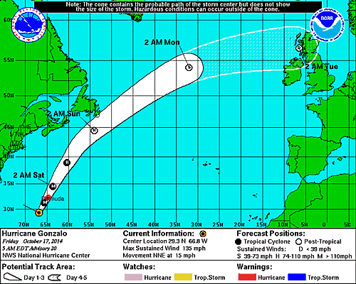
The latest National Hurricane Center forecast has Gonzalo coming very close to eastern Newfoundland early Sunday.
HURRICANE GONZALO
Gonzalo remains a major hurricane this morning with winds up to 130mph and a pressure of 946mb. The storm is located 240 miles (385km) south southwest of Bermuda while moving north northeast at 15mph. On this present course the hurricane will arrive very close to Bermuda late today. Winds at 7:30 were already over 60km/h (38mph) on the island. Heavy rain, in excess of 150mm (6 inches) along with dangerous winds and a powerful storm surge will arrive shortly. Once the storm moves past Bermuda it will begin to slowly weaken and transition into a powerful post-tropical storm. Winds and rain will begin to affect Atlantic Canada coastal waters by Saturday afternoon. It is still early to pinpoint the exact impact on Newfoundland, but heavy rain is likely along the southeast coast along with heavy surf. High surf is also forecast for Nova Scotia. Strong winds may impact the Avalon Peninsula if Gonzalo makes landfall in Newfoundland. The current NHC track has the storm remaining offshore.

Thursday, October 16, 2014

Windy, warm & wet

It feels more like a mid July morning in southern Quebec than October with temperatures in the high teens and high humidity. Tuesday was a record warm day in Montreal with a high temperature at Trudeau Airport of 24.8C (77F), beating the old record of 22.8C set in 1970. We were part of a bunch of record high temperatures including 28C (84F) at Massena/Cornwall and 26C (79F) at Burlington, Vermont. Burlington also posted another record on Wednesday when the temperature hit 27C (80F), this beat the old record that dated back to the 1930's. Montreal was a very warm 24C (76F) on Wednesday, short of the record of 26C. The warm and humid air is being pushed north by a combination of the slowest moving cold front ever and the broad circulation around high pressure in the Atlantic Ocean and Hurricane Gonzala. An area of very heavy rain is associated with the slow moving frontal system to our west, and that rain will arrive in Montreal today. Look for periods of rain with some thunder lasting into Friday with perhaps as much as 25mm (1 inch) for the St. Lawrence Valley.  Temperatures will continue warm with highs near 22C. The normal high for this date is 12C (54F) with the low around 3C (39F), so it is exceptionally warm, especially the overnight lows which have been warmer than the normal highs! We are on borrowed time, it will turn windy and colder this weekend as a strong cold front crosses Quebec and Ontario on Saturday. Temperatures will return to normal values by Sunday, even below average with showers and perhaps some flurries over the highest elevations. Highs will only be near 10C (50F) with lows near 0C (32F) by Monday morning.

NOAA image showing a well defined and powerful Hurricane Gonzala (middle right) over the Atlantic Ocean.

HURRICANE GONZALA
Gonzala this morning is a major storm located 540 miles (865km) southwest of Bermuda. The hurricane has 140 mph winds and a central pressure of 945 mb, a Category 4 storm, and one of the strongest Atlantic Basin hurricanes on record for October. Gonzala is moving north at 9 mph, and will come very close to Bermuda on Friday with a large storm surge, up to 150mm (6 inches) of rain and fierce winds. Warnings are in effect, and precautions are being rushed today to protect life and property. Beyond Bermuda it looks like the storm will transition into a strong post tropical storm and affect eastern Nova Scotia and Newfoundland this weekend. Very heavy rain and strong winds are possible, but the forecast details need to be fine tuned. The storm will begin to affect Atlantic Canada by Saturday.

Tomorrow: The 60th Anniversary of Hurricane Hazel was October 15, 2014. I will take a look back at one of the strongest storms to affect Canada tomorrow.

Tuesday, October 14, 2014

Near record warmth today for Montreal & southern Quebec

After a very cold start to Thanksgiving Monday with widespread frost across southern Quebec and lows near 1C (34F), we warmed rapidly to 18C (65F). It was a perfect day for cleaning up the leaves and sadly cutting down the shrubs and flowers as we prepare for the upcoming snow and cold. I also managed to put the patio furniture away after enjoying it one last time.

The warmth came as a result of strong high pressure moving into the Atlantic and low pressure forming in the Mississippi Valley. The result has been a strong push of warm and increasingly humid air from the southern US. The flow will strengthen today with a forecast high of 24C in Montreal. If it occurs it will break the previous record high for the date, 22.8C (73F), established in 1971. It should be a dry day with partial sunshine this afternoon. The aforementioned low pressure area will lift north across the Great Lakes and eventually sweep a cold front into the St. Lawrence Valley by Thursday. Until then it will remain very warm for mid-October with highs in the 20's and lows in the teens. By Thursday expect a period of moderate rain with perhaps 25-50mm (1-2 inches) area wide into Friday morning. Temperatures will begin lowering through the teens to around 10C (50F) for a high by Sunday as we settle back into reality.

The path of Hurricane Gonzala as forecast by the National Hurricane Center.

SEVERE WEATHER
The weather system bringing us this late season warmth is also responsible for a late season severe weather outbreak. Thunderstorms across the southern US on Monday produced nearly a dozen tornadoes and killed two in Arkansas. The storms stretched from Texas into Alabama and will spread eat today from Virginia to Florida. There may even be some thunder in northern New York and southern Quebec by Thursday, but no severe weather is forecast.

The tropics have also become active as we have a strong Hurricane Gonzala north of Puerto Rico this morning. Gonzala is a strengthening storm with winds of 110mph and is expected to become a major hurricane today while moving away from the islands at 13mph. The eye of Gonzala is about 90 miles (145km) north northeast of St Thomas with a lowering central pressure at 974mb and deepening. The storm lashed the Virgin Islands on Monday with heavy rain and strong winds as well as Puerto Rico. Winds gusted to 88mph on the island of Antigua with downed trees and roofs off many homes. The next target for the hurricane will be Bermuda followed by a gradual weakening as it approaches Atlantic Canada by next weekend.

Thursday, October 09, 2014

Windy & cool fall day for Montreal


It is a much cooler morning here on L'Ile Perrot today with a gusty northwest wind and a current temperature of 6C (43F). Montreal had a very wet Wednesday with heavy rain in the morning followed by some clearing. The afternoon featured blustery winds over 50km/h and more periodic heavy showers with even some thunder. I recorded one of those showers here on L'Ile Perrot (video above) at around 2:30pm Wednesday. Winds were very strong with this particular batch of storms, in excess of 70km/h at times. Total rainfall amounts in Montreal ranged from 20 to 25mm yesterday (up to 1 inch) with two day totals close to 32mm here at my home.

Today will be a typical southern Quebec fall day with a mix of sun and clouds and the chance of an afternoon shower. It will be very cool, 11C (52F) and windy. Tonight, expect partly cloudy skies and cold lows down to 5C (41F).

Wednesday, October 08, 2014

NO Lunar Eclipse for Montreal - just heavy rain

The full lunar eclipse this morning as captured by NASA.
Those in southern Quebec hoping to see the sensational celestial show put on by the sun, earth and moon were thwarted by clouds and rain this morning. The second full lunar eclipse of 2014 started at 4:15AM ET this morning and reached its peak at around 6:15AM. The full hunters moon turned blood red as it passed into the earths shadow. The next full lunar eclipse will be on April 4, 2015. Unfortunately the other story of the day stopped us from seeing any sign of the moon here in Montreal. A strengthening low pressure area is lifting from the Great Lakes north toward Hudson's Bay today while producing a large area of heavy rain and even a few rumbles of thunder. Montreal has had around 15mm of rain since 2am. Combine that with yesterdays thunderstorms and we are over 25mm (1 inch) for the 24 hour period. The storms on Tuesday came on suddenly in Montreal around the middle portion of the day with rapidly darkening skies, heavy rain, gusty winds and numerous reports of pea to marble size hail. We returned back to sunshine just as quickly.

Dark skies and heavy rain stopped us from seeing the lunar eclipse in Montreal. The rain also slowed the morning commute to a crawl with poor visibility and some flooding reported. Above Highway 20 at Woodland. (ValleyWX)

The rain this morning will taper off shortly across southern Quebec, but with the risk of more showers or a thunderstorm this afternoon along a trailing cold front. Winds will increase as well this morning here in the St. Lawrence Valley between 30-50km/h with gusts up to 70km/h possible this afternoon. Temperatures will be rather mild today around 16C (61F) in Montreal but drop this evening into the upper single digits under partly cloudy skies. On Thursday expect a mostly cloudy, windy fall day with some showers around, cool at 11C (52F). The weather will clear out for the upcoming Thanksgiving holiday weekend but be cool with highs around 12C (54F) and lows down to 3C (38F) with the risk of frost in southern Quebec and Ontario.

Monday, October 06, 2014

Unsettled weather week

It turned out to be a decent Sunday with the sun and clouds playing in a gusty northwest wind. The fall colours were in fine form across the St. Lawrence Valley including Lancaster, Ontario yesterday. (ValleyWX)
We managed to salvage half this past weekend here in Montreal, which was better than I had imagined at the start. The clouds and heavy showers associated with the strong cold front on Saturday managed to clear out rather nicely for Sunday. Montreal had around 25mm (1 inch) of rain on Saturday with a gusty northeast wind and cool temperatures. By Sunday it was a much more fresh air mass with moderate northwest winds, up to 50km/h at times, and temperatures in the low teens (50's).

Our weather for the start of this week will be controlled by a very strong early fall storm located in Hudson Bay. This storm is producing a wide area of snow and very strong winds across portions of Nunavut and northern Manitoba. Its effects on southern Ontario and Quebec will be in the form a persistent northwest flow of cool, moist air with a couple of areas of clouds and showers rotating throughout southern Quebec into Wednesday. In between the cloudy periods and showers we may see a few glimpses of sun like this morning. Temperatures will be seasonable today at 16C (60F) but rather mild on Tuesday and Wednesday, close to 19C (66F). By Wednesday a more important area of showers will lift northwest off the Atlantic across New England and into Quebec with perhaps a decent area of rain. More on that tomorrow. We will not see clearing skies before Thursday, and it will turn cooler and dry for next weekend.

Thursday, October 02, 2014

Cood & wet weekend ahead

September has come to an end, as quickly as the rest of the months in 2014. This year is really flying by as is our weather. After a perfect weekend, it has been a rather sloppy week. Ideally high pressure was supposed to bring us sunshine and warm temperatures, however a northeast wind has maintained a layer of stratus clouds over southern Quebec. The low angled fall sun has been unable to burn of the marine layer and thus it has remained cloudy. The cloud cover and light northeast flow has also managed to lower the temperatures with highs generally from 15 to 17C (59-63F). There is some hope that the clouds will burn off today, but as I write this blog, it remains cloudy here in Ville St. Laurent and only 12C (54F).

With September in the history books we can now take a look at the weather stats for the month. Basically we started off very warm, turned very cold in the middle days with an early frost in the suburbs and warmed a little at the end. The high temperature at Trudeau Airport was 31C (88F), low 1.2C (33F). The monthly average was 15.8C (59F) compared to the long term average of 15.5C (58F). The airport recorded 50mm (2 inches) of rain, well below the normal of 83.1mm. As a matter of fact it has been very dry for the last two weeks. Here on L'Ile Perrot my numbers are very close to those at Trudeau, high 32C (90F) the low 1.2C (33F) with an average of 16.1C (61F). I did have more rain with a couple of thunderstorms occurring here that missed the airport, recording 67.8mm.

Whitehorse in the Yukon has had a snowy week with over 10cm (4 inches) accumulating. It remains very cold across the far north and some of that air will slip south into the central Great Lakes this weekend.

The weekend at this time looks more like October with clouds, colder weather in the middle teens, and a decent rain on Saturday, perhaps as much as 25mm. The culprit will be a strong cold front slipping southeast through Ontario and into Quebec on Saturday. This front has some really cold air behind it, below freezing across the Yukon and the Northwest Territories/Nunavut. There has even been a decent snowfall across portions of the Yukon including Whitehorse, and it is snowing in Yellowknife this morning. Winds have been very strong as well. We won't see snow but temperatures will drop into the lower teens and upper single digits over the weekend and the early portion of next week with lows down to 5C.

Monday, September 29, 2014

Was that Indian Summer?

NOAA satellite image of the foliage bursting out in reds. oranges and yellows across the Adirondacks, Eastern Ontario and southern Quebec this weekend.
 What a spectacular weekend in Montreal by any standards, let alone late September. Montreal just missed a record high on Saturday as we reached 26C (79F) officially at Trudeau Airport. However most other locations around the city were between 26C and 29C (79-85F). The record for the date was 26.6C (80F) set in 2003. I recorded 27.7C (82F) at my home on L'Ile Perrot. Sunday was an exact replica of Saturday with warm sunshine, humid and a light breeze. The temperature again reached between 25-27C (77-81F). High pressure responsible for the summer like weather has drifted off the east coast this morning and a very weak backdoor cold front has settled across the St. Lawrence Valley with clouds and a few sprinkles. The temperature remains mild for this time of year, currently at 18C (65F) it will slowly drop as winds turn out of the northeast in the valley and increase up to 50km/h. The normal high is 16C (60F). We will have clouds tonight and again Tuesday with temperatures settling back to near normal. By Wednesday more sunshine and above normal temperatures will return lasting through Friday when a strong cold front will approach Montreal. No really cold air is on the horizon however as the jet stream remains well to our north keeping the arctic air where it belongs.

Indian Summer
Sure it was a perfect weekend, but was that Indian Summer? The broad definition of the term Indian Summer, dating back to 1700's New England, varies depending on which source you look at. It has many different definitions and interpretations. It is generally defined as a period of above normal temperatures with hazy skies and warm southerly winds at least here in southern Quebec. It  can last several days with temperatures well above normal, and typically occurs after the first frost. According to Native Americans it occurred very late in the fall season between November 11 and 20. However the National Weather Service in the US has it occurring anywhere between late September and middle November. There was a light frost in southern Quebec on September 19, and that was a three day period of well above normal temperatures, so we may have indeed just had Indian Summer. But it is still early in the fall season and if that was Indian Summer, I expect it will not be the last.

Friday, September 26, 2014

Spectacular Fall Weekend for Ontario & Quebec


L'Ile Perrot is starting to see the colours burst out. It will be a perfect weekend in Quebec and New England for checking out the foliage, picking apples or any outdoor activity. Enjoy it the showers and cooler weather return next week.
With the exception of overnight and early morning fog patches, it will be simply a spectacular weekend for late September. Strong high pressure will drift to our southeast allowing for a light southwesterly flow of warm air. The result will be wall to wall sunshine for the rest of Friday as well as the entire weekend. Temperatures will be well above normal with highs ranging from 25 to 27C (77-81F). The same forecast holds true for Ottawa, Toronto, Montreal and south into New York and New England. Overnight lows will be seasonable around 10C (50F) with fog developing in the typical spots.

Yesterday was a warm day right across the country with record heat in Manitoba and Saskatchewan in stark contrast to the snow and frost just 10 days ago. Estevan was the warmest place in the country at 34.4C (95F), while Assiniboia and Gravelbourg reached a record breaking 34C (94F). Regina and Moose Jaw broke records as well reaching 33C (92F). Cooler weather will arrive this weekend in western Canada and spread east by next week. Some showers will also arrive in our region by Monday.

Wednesday, September 24, 2014

25th Anniversary of Hurricane Hugo - Carolinas to Montreal

Powerful Hurricane Hugo making landfall at midnight on September 22, 1989. Just 24 hours later, the storm would be near Ottawa and Montreal.
Long before hurricane Sandy, Irene, Juan, Katrina and Andrew, among other infamous storms, there was Hugo. Hurricane Hugo was a small but powerful Atlantic that developed off the coast of Africa on September 10, 1989 and moved rapidly across the northern Caribbean and into the Atlantic Basin. Hugo would reach Category 5 at his strongest, with winds over 260km/h. The storm took an odd approach to the coast, slamming into the low country of South Carolina, with 140mph winds at exactly midnight on September 22. Hugo was devastating, with a record storm surge of nearly 20 feet north of Charleston and south of Myrtle Beach. The infrastructure and dune system along the coast was demolished, from extreme southern North Carolina to northern Georgia. But hardest hit were the communities north of Charleston, where the surge virtually wiped the area clean. Forty-nine people lost there lives and a record (at the time) $7 billion dollars in damage was recorded.

Environment Canada map showing the path of tropical storm Hugo across eastern Canada. (Double click map for a closer look).
Quebec & Ontario
Inland Hugo was fast and furious, with winds that produced major damage from North Carolina towards the southern Great Lakes. The hill country of central and western North Carolina was hammered by high winds that leveled entire forests. Trees took out power lines and landed on homes and cars. Power was out for weeks as a result. Further north, Hugo entered southern Ontario late on September 22nd and moved rapidly from Kingston towards Ottawa and into the Laurentians. Montreal was on the warm south side of the storm. We had lots of wind, but little rain. In Toronto, 75km/h winds and 47mm of rain occurred, but only 11mm of rain in Montreal. The wind in Ontario cut power to thousands of homes. In southern Quebec, the storm arrived around midnight on Saturday, September 23rd, just 24 hours from South Carolina to Montreal. I was working for the Montreal Gazette at the time, driving in the Lasalle and Verdun area. It was a wild night, with winds gusting from 70-95km/h in the St Lawrence Valley and stronger on the south shore, 98km/h at St. Hubert. Numerous trees fell and power went out in over 13,000 homes in metro Montreal including my home in Verdun for 12 hours. Another feature of the storm was the warm tropical air that arrived with Hugo. Montreal, reached 29C (85F) on September 22nd, and it was still nearly 24C (76F) at midnight on the 23rd. But as the storm pushed through the region, the mercury fell rapidly and dropped to 5C (41F) by 11pm on the 23rd.

Hugo then affected New Brunswick, with a peak wind gust to 124km/h at Moncton. Power was out to nearly 15,000 New Brunswick homes. The 1989 apple crop took a beating, with much of the fruit stripped from the trees in New Brunswick. Heavy rain fell north of the track across Labrador and into Newfoundland. Hugo dissipated on September 25th.

Monday, September 22, 2014

Fall arrives at 10:29PM with perfect weather ahead

The growing season is not quite done for 2014. Despite the cold weather and frost this past week, I still have spectacular flowers growing on L'Ile Perrot.
The first day of Autumn 2014 is here after a rather warm and humid weekend in the St. Lawrence Valley. Temperatures were in the mid 20's with showers and even an isolated thunderstorm over the weekend. Not much rain fell in Montreal with 5.8mm here on L'Ile Perrot and officially 6.2mm at Trudeau Airport. It has been windy overnight with gusts over 50km/h across the island of Montreal. Much colder air has settled into southern Quebec this morning with the temperature down to 9C (48F). Expect a cloudy and windy day in Montreal with the temperature only gaining a degree or two. That is the bad news, the good news is we are in for a spectacular week of weather. Once the skies clear this evening, we will have nothing but sunshine right into next weekend. Along with the sun will be a period of very warm weather for late September. Expect temperatures to warm through the high teens into the mid 20's by next weekend a full 8-10 degrees above normal. Highs may even approach 27C (80F) in some locations next Saturday. After the drizzle this morning, no precipitation is forecast through the end of the week.

As mentioned the Fall Equinox occurs at 10:29pm EDT today. The Latin term equinox means equal night with the idea being that there is equally 12 hours of daylight and darkness today. From this point on the days become increasingly short as we head towards the winter solstice. In fact the sunrise today in Montreal is at 6:43am and sets at 6:52pm, so daylight is still winning for now with 12:08 minutes of daylight.

Friday, September 19, 2014

After the frost - a warmer weekend ahead

Not a very dramatic photo, but it does tell the story, frost on this last week of summer. The temperature dipped to 1C (33F) on L'Ile Perrot this morning with patchy frost around, two to three weeks ahead of the average date.
After we get the nonsense of this first frost out of the way, it looks like the weekend will be much warmer. Fall does not arrive until Monday but the geese are heading south this morning, and I wish I could join them. Temperatures under clear skies dropped quickly last night, but a northeast breeze saved us here in Montreal from widespread freezing temperatures. The low on L'Ile Perrot was 1C (33F) just after 4am. The mercury dropped to -1C (30F) in Cornwall, -3C (27F) in Kemptville, and a very cold -5C (23F) in St Jovite, 1 hour north of Montreal. There is patchy frost on the ground here in the city, and a coating of thin ice on some windshields including mine. Other regions around us were much colder as noted, with several hours of freezing temperatures including the Adirondacks, Laurentians, Townships and rural eastern Ontario. Lows in those regions ranged from 0 to -5C.

We will recover nicely today under sunny skies with highs near 14C (56F). Clouds will be on the increase tonight as a warm front moves into the St. Lawrence Valley. The front will bring scattered showers on Saturday, it will be windy and warmer with highs near 22C (72F). Most of the day will be dry and great for outdoor activities. By Sunday a cold front will bring more general showers, a wet and cloudy day can be expected, but it remain mild, near 22C.

Thursday, September 18, 2014

Frost Advisory for Southern Quebec - NY & Vermont

Our average frost in Montreal typically does not happen until the first week of October on average. But here we are, the last week of summer 2014, and is it not fitting that we have a frost advisory in effect. The entire region is under the advisory with the exception of metro Montreal near the St. Lawrence River and the Richelieu River Valley. A cold front has slipped south of Montreal early this morning. The front produced between 4 and 5mm of rain overnight and now a stiff northerly wind will develop along with steady or slowly falling temperatures. The high here on L'Ile Perrot was 13C (55F) at midnight and we have been falling since. It is currently a chilly 9C (49F). Look for partly sunny skies today and clear skies tonight. Temperatures will fall tonight to around 0C (32F) in most regions of southern Quebec but as cold as -2 to -4C in the Townships and Laurentians. The same cold conditions can be expected in Eastern Ontario and northern New York and Vermont. Freeze and frost advisories/warnings are in effect in those areas as well. We will see sunshine on Friday with temperatures a little warmer, near 13C (55F). Low pressure will affect Montreal over the weekend with showers developing Saturday and lasting into Sunday. It will be much milder with temperatures near 20C (68F) both days.

Monday, September 15, 2014

Below normal temperatures to continue in Montreal

The sun breaks through the clouds early Sunday morning on Mount Washington, NH. It was a sign of the seasons as cold temperatures produce rime ice and there was even some freezing rain over the weekend.
This is the last full week of summer, but if you stepped outside at any point this weekend, you would think it has checked out already. It was a weekend more suited for mid-October, with cold temperatures, lots of cloud cover, and at times heavy rain on Saturday. Saturday produced 15-25mm of rain across southern Quebec, far more than I was expecting. What should have been spotty showers, turned into a deluge through the middle afternoon. I recorded 18mm here on L'Ile Perrot. The clouds and rain kept temperatures cool with highs near 13C (55F) well below the normal of 19C (66F). Sunday was a touch better, dry, but just as cold with highs near 11C (52F) and lows near 4C (39F).

We nearly had frost early this morning here on L'Ile Perrot with the temperature bottoming out at 2.8C at 3am. The coldest readings were observed across the Townships with several reports of 0C. Clouds and fog developed after that point helping the temperature to warm a few degrees to 7C where we sit now. The week looks rather unsettled but with a very slow warming trend, and by Saturday we should be back to normal, 20C. In the short term clouds today with some sunshine and much warmer highs of 17C (63F). Overnight will be milder but with showers developing that will persist into midday Tuesday. By Wednesday skies should clear out but it will be cool once again with high in the lower teens. The next risk for frost will come by early Thursday morning as lows again head towards 0C across southern Quebec and eastern Ontario.