Thursday, March 24, 2016

Freezing rain warning for Montreal and eastern Ontario

Roads were impossible to drive on around Denver on Wednesday, as a late winter storm blasted the region. (CSP Photo)
Strong low pressure continues to lift north this morning from Iowa towards the Great Lakes. An elongated warm front stretching from the storm lies to the south of Montreal, over New England. This front separates very warm air from cold air here in the St. Lawrence Valley. Precipitation will arrive this morning in Montreal, in the form of snow. Expect 5 to 10cm of snow for Montreal, with 10-15cm north and west of the city including Ottawa. The snow will change to sleet and freezing rain in Montreal this afternoon, and continue into the overnight hours. Several hours of freezing rain are possible. Temperatures will be chilly today, with a persistent northeast wind, but will warm overnight to the freezing point and above for Friday. Any precipitation will taper off to showers on Friday morning. The balance of the long weekend looks good, with dry weather and mild temperatures through Easter Sunday.

This morning, southern and eastern Ontario are reporting freezing rain and snow. The result has been widespread power outages, along with school closings and flight cancellations at Pearson Airport in Toronto. Travel along the 401 and 417 will be difficult today. Weather warnings are posted for all of southern Ontario and Quebec for today and tonight.

This storm's main area of low pressure has produced some wild weather over the past 24 hours. As is typical with most spring storms, this system has a big variation in temperatures. On Wednesday, heavy snow fell west of the storm track in Denver, with numerous road closures and nearly 80,000 without power. At the same time, on the warm side of the storm, strong winds were fueling brush fires in Oklahoma and Texas, with severe thunderstorms and tornadoes in Kansas and Nebraska. Today, blizzard conditions stretch across the upper Midwest from Minnesota to Michigan. Heavy snow will move into central Ontario and Quebec later today, with up to 30cm forecast.

Wednesday, March 23, 2016

Storm to impact Ontario and Quebec with snow and ice

Significant freezing rain and snow is possible across southern Ontario and Quebec with this next storm.
One thing you should know about March and April in Montreal is that they typically produce some of our largest snowfalls. History has shown this, with the largest storm being the March 3, 1971 blizzard. But there are so many more. On April 3, 1975, after what was a very mild March, 32cm of snow, driven by 100km/h winds, fell. Other notable storms include, April 9, 2000, 34.5cm, April 15, 2007, 37cm and April 27, 2010, 29.8cm. In March 1955, 108cm of snow fell in one month. To compare, Montreal has recorded only 95.8cm this entire winter, the lowest amount of the last 25 years. The most telling statistic I could find was in May 1963. After a high of 22C (72F) on May 9th, strong low pressure and cold northeast winds dumped 25.6cm of snow on the city in 36 hours, May 10 and 11th.

Another 4cm of wet snow fell on L'Ile Perrot and Montreal overnight.
That brings us to Spring 2016, with more snow on the ground this morning. L'Ile Perrot had about 4cm of very wet snow overnight. It has now ended and we can expect a partly cloudy day, with a high near 2C (36F). Our attention will then turn to a rapidly strengthening late winter storm that will move from Colorado towards the eastern Great Lakes. This storm will produce a swath of rain, snow and freezing rain. As has been the case all season, the exact path remains a little uncertain. One thing that is known is that Montreal is going to receive a significant amount of precipitation from Thursday into Good Friday.

Widespread winter storm watches and warnings are now in effect across the US Midwest into Ontario, and they should be expanded into Quebec later today. Snow will begin in Montreal early Thursday along with strong northeast winds up to 50km/h. The snow will change to freezing rain late in the day and likely over to rain overnight into Friday, as temperatures warm from -4C (25F) Thursday to well above freezing Friday. Amounts of snow and ice will likely exceed 15cm over most of southern Quebec. Where the precipitation remains as snow, north of Montreal, over 25cm is possible. Skies will clear for the weekend, with warmer temperatures returning by Easter Sunday.

Monday, March 21, 2016

First week of spring more like winter in Montreal

The next storm system will move from Colorado into the Great Lakes by Thursday, with the potential for snow and freezing rain in Montreal and Ottawa.
As is often the case, the first week of spring will feature more winter weather then most of the season did. Spring arrived at 12:30AM early Sunday morning, but most of the weekend featured a cold north wind and high temperatures near the freezing point. The normal high in Montreal for March 21st should be 4C (39F). This morning, we start the day at a chilly -6C (21F), along with cloudy skies. The cloud deck is from a coastal storm located east of Cape Cod, that is expected to affect Atlantic Canada today. Precipitation this morning is largely confined to coastal areas of New England. Snow will spread into Nova Scotia and New Brunswick later today, with up to 20cm possible. Only a stray snowflake is possible in southern Quebec. The sun should return to Montreal this afternoon, with a high temperature near 3C (38F).

Spring Snow for Montreal
On Tuesday, weak low pressure will slide across the Great Lakes and along the US border. Clouds will increase early in the day, followed by light snow by evening in Montreal. A good 5cm of snow is forecast by Wednesday morning, from the Ottawa Valley into southern Quebec. Later in the day Wednesday, an arctic boundary will slip just south of Montreal, with cooler air surging into the St. Lawrence Valley. With temperatures below freezing into Thursday, another surge of moisture will arrive as low pressure develops over the US Midwest. This storm will provide Montreal, southern Quebec and parts of Ontario with a messy mix of rain, freezing rain and snow, as we head into Good Friday. At this time, the track of the storm remains uncertain. The exact path will determine what type and amount of precipitation we can expect in Montreal. Amounts may be significant, along with gusty winds. If you have travel plans late Wednesday through Friday in Ontario and Quebec, pay close attention to future forecasts. Temperatures for most of this week will remain below normal, with warmer weather expected by Easter Sunday.

Friday, March 18, 2016

Quebec cities participating in Earth Hour 2016

Visit earthhour.org to see how you can take part in Earth Hour 2016 this Saturday.

Saturday, March 19th, between 8:30 and 9:30pm local time, is the 10th annual Earth Hour. Participants are asked to shut off all non-essential electricity for one hour and think about their commitment to climate action for the year ahead.  This annual symbolic event, draws attention to climate change, carbon emissions, electricity consumption and the impact our actions are having on our planet. The event has grown over the last decade to include a record-breaking 178 countries this year, on six continents and in 24 time zones. Earth Hour is sponsored by the World Wildlife Federation here in Canada, with dozens of municipalities participating. The City of Montreal will turn off the lights in all the main administrative buildings, including city hall, as well as the cross atop Mount Royal, at 8:30pm Saturday night.

After very mild weather and thunderstorms on Thursday, Montreal awoke to a blanket of snow this morning. (ValleyWX)

Potential Snowstorm
We had a wild few hours of weather in Montreal Thursday afternoon. Rare March thunderstorms swept across southern Quebec between 3 and 5pm, with small hail, strong winds and heavy rain. Overnight, another cold front crossed the region, with light rain changing to snow around 3am. We had a good 2-3cm of snow here on L'Ile Perrot this morning, but it is now in the process of melting. This weekend will be chilly, with mostly sunny skies and highs near 0C (32F). Overnight lows will be cold, down to -10C (14F). Late Sunday, low pressure is forecast to develop near Cape Hatteras, North Carolina and move northeast along the eastern seaboard. Forecast models have been all over the place, with the track of this particular system varying from a complete miss to significant snow as far west as Montreal. We will have to keep an eye on this storm, but at this time, my feeling is that we will get just a few flurries and gusty northeast winds late Sunday and Monday, with not much more for southern Quebec.

Thursday, March 17, 2016

Wide variety of weather over the next 24 hours in Montreal

A strong spring storm has produced heavy snow in Manitoba, western Ontario and Minnesota, as well as severe thunderstorms and tornadoes in the US Midwest. A wind gust to 96km/h occurred in Toronto on Wednesday. On Tuesday, the Trump Towers in Chicago was struck by lightning, perhaps a sign of just how polarizing he is.
Nearly all the snow has now melted in Montreal with the exception of a few dirty patches. We can thank nearly two weeks of well-above-normal temperatures, along with rain for the rapid thaw here in southern Quebec. Even the overnight temperatures have remained above freezing. The weather will turn rather active over the next 24 hours, as a strong storm moves from the western Great Lakes into central Quebec.

After the overnight rain, we can expect partly-cloudy skies to start the day, with a mild high of 12C (54F). This afternoon, a strong cold front will cross the region, with gusty winds and the possibility of isolated thunderstorms. Some of the storms may produce small hail. Winds will gust as high as 50km/h in Montreal and up to 80km/h in any thunderstorms. Colder air will filter in behind the front, with dropping temperatures and light rain changing to snow by midnight. The flurries will continue overnight with a low of -3C (27F). We may have as much as 2 or 3cm of snow by Friday morning in some locations across southern Quebec. Friday will be breezy, with clearing skies. It will be much colder than it has been on Friday, with a high near 1C (33F). The weekend looks chilly as well, with overnight lows near -10C (14F) and daytime highs near 0C (32F).

A coastal storm will likely leave Montreal on the western edge of the precipitation once again. (AccuWeather)
Potential Spring Snowstorm
Despite Sunday being the first day of spring, a strong ocean storm is forecast to develop along the US east coast by late Saturday and move towards Atlantic Canada by Monday morning. At this time, it looks like Montreal will remain on the western edge of the system, but it bears watching. Measurable snow is possible from the Eastern Townships into New England, with cold northeast winds and a few flurries in Montreal by Sunday night and Monday. A major snowstorm is quite likely for portions of eastern Quebec into New Brunswick and PEI.

Monday, March 14, 2016

Wet weather week ahead for Montreal

Expect an unsettled weather week in Montreal with plenty of clouds and showers. The silver lining will be mild temperatures along with melting snow. (AccuWeather Photo)
The snow is melting very quickly in Montreal, as temperatures have been 5 to 10 degrees above normal for the last week. The trend will continue this week, along with intermittent rain through Friday. Clouds will rapidly increase this morning, with rain developing by noon in Montreal. Some locations across the Eastern Townships, as well as north of Montreal and into the Ottawa Valley, may see an hour or two of light freezing rain at the onset. All precipitation will change over to plain rain by this afternoon, as the temperature reaches 5C (41F) today.

Showers will prevail for most of the week, as the region is influenced by several areas of low pressure. Much colder temperatures will begin to filter into western Canada, and eventually the Great Lakes, by the end of the week. Until then, expect daily highs either side of 10C (50F) through Friday in Montreal, southern Quebec and eastern Ontario. Colder weather early next week may increase the possibility of some snow in Quebec and New England, but we are still a week out and the forecast may change. Leave the snow tires on for now.

Thursday, March 10, 2016

Warm air surges north into Ontario and Quebec

An early and warm spring may be on tap. It is looking like the entire month of March may remain above freezing for daytime highs in Montreal.
The melting continues in southern Quebec after daytime highs on Wednesday reached between 10 and 15C (50 to 60F). The normal high for the second week of March should be 1C (34F). This morning, we are dealing with widespread fog with temperatures near 7C (45F) in Montreal. A cold front slipped south of the city overnight. As a result, the temperature will drop today, down to the freezing point by evening. Low pressure responsible for major flooding across the south central US will lift a plume of moisture north along the cold front today. At this time, I expect most of the rain to remain south of Montreal, with the heaviest falling across central New York and Vermont, up to 25mm (1 inch) possible. Montreal can expect just a cold drizzle, with cloudy skies today into this evening.

Stay OFF the ice
On Friday, skies will clear out with mild temperatures returning. The high temperatures will range from 5C to 11C (41 to 52F) most of the weekend across southern Quebec. It should remain dry through Sunday. An important note on this mild weather; All ice on area rivers and lakes is very unstable and thus extremely unsafe to be on at this time. On Wednesday, another drowning occurred after a man fell through the ice while fishing on Shelburne Pond in Vermont.

It was very warm just to our south on Wednesday. While Montreal managed 11C (52F) at Trudeau Airport, I recorded 13C (55F) here on L'Ile Perrot. The high reached 20C (68F) in Toronto, a record-breaking 21C (69F) in Burlington, Vermont and a downright hot 27C (81F) in Albany, New York.

Monday, March 07, 2016

Has spring sprung in Montreal?

A surge in warmth this week will give southern Ontario and Quebec high temperatures from 10 to 15C (50 to 60F) by Wednesday.
Despite the heavy wet snow and chilly temperatures this morning in Montreal, it appears we may be turning the corner on this winter. The snow should end shortly with around 5cm or so for the city. It was not much of a winter, with only one really big snowstorm on December 28th, followed by a handful of smaller systems. The numbers back this up, with only 128cm (53 inches) of snow at Trudeau Airport from December 1 to February 29th. The normal for that time frame in Montreal should be 141cm. Much more snow fell north of the city, with very little south of the city into northern New York and Vermont. All winter long, the storm track either split our region, leaving us on the outside of the precipitation, or brought warm air with snow or freezing rain changing to rain.

Despite the surprise heavy wet snow Monday morning in Montreal, it looks like much warmer weather will arrive very soon.

As far as temperatures go, this is where we really see just how warm this winter turned out. The average daily temperature for December through February in Montreal was -3.4C (25.8F), while it should have been closer to -8.4C (16.8F). Those numbers represent a tremendous seasonal difference. You may recall a record 17C (63F) on Christmas Eve, as well as several record highs in January. That being said, I still have lots of ice and snow in my yard, which tends to keep temperatures down, so any real surge in warmth will have to eat away at that before we see true spring weather.

This week will feature typical March weather for southern Quebec, as we start the week with snow, warm up to above 10C (50F) on Wednesday, and then possibly have more snow Thursday night. In general, as we look ahead throughout the month of March, I see milder-than-normal weather prevailing, with lots of above-freezing temperatures expected. A slight dip in the mercury around the 24th may allow for one last sneaky snowstorm. Time will tell, but it really looks like spring is on the horizon.

Thursday, March 03, 2016

The mystery of the missing blizzard in Montreal

Near-blizzard conditions were observed along the St. Lawrence River north and east of Montreal. A section of Highway 20 east of Quebec City was closed from Levis to La Pocatier, most of Wednesday morning. (Transport Quebec)
That was not much of a storm, at least here in Montreal. A swath of heavy snow did impact regions from central Ontario, through the Ottawa Valley, and northeast towards Quebec City. Along that path, between 20 and 30cm of snow fell. South of there, the snow trailed off quickly. Here in Montreal, warmer air aloft turned the snow to ice pellets. Trudeau Airport measured a messy mix of close to 10cm, along with strong winds up to 75km/h.

Other parts of southern Quebec, Ontario, Vermont and New York had more freezing rain than snow. (Black Forks Towing Photo)
So what happened? In short, the system traveled about 100km further northwest than originally indicated by several forecast models. This introduced a small zone of warmer air above the surface, which cut off the snow here in Montreal and produced freezing rain and sleet. Environment Canada is not alone in the assessment of this storm, several other weather agencies both public and private, on both sides of the border, called this one wrong. But, forecasting winter storms is one of the most challenging things a meteorologist has to do, especially here in southern Quebec. A change in trajectory of just a few kilometres can mean the difference between a major impact winter storm and a complete miss. As we have seen this winter, just a few kilometres of geography can have a wide range of temperatures and precipitation types.

Where the Quebec Weather Centre made a big mistake on this particular system was upgrading its status to a blizzard. A blizzard is the worst type of winter storm, very few achieve this status, and this system was never that strong from the onset. At best, marginal blizzard conditions might have occurred for an hour or two in the dead of night, and a winter storm warning would have covered that scenario just fine. All the neighbouring weather offices chose to use that type of warning to cover this storm. I have been writing and following weather in the St. Lawrence Valley since I was 12, which would date back to 1978. In all those years, I don't recall Environment Canada here in Quebec issuing a blizzard warning regarding any potential snowstorm.

In any event, milder weather is on the horizon and Spring is close at hand. If you believe the extended forecast, it looks like an early, very warm spring, starting as soon as next week.

Tuesday, March 01, 2016

Blizzard Warning for Montreal

A blizzard warning is in effect for metro Montreal as strong low pressure moves from the lower Great Lakes into New York.
2:00 AM UPDATE: Freezing rain is falling on L'Ile Perrot with very strong winds at 2am. It appears the storm is taking a track a little further to the north and west. If this trend continues, Montreal can expect significantly less snow than originally forecast. The blizzard warning has been changed to a winter storm warning for most of the region.

A rarely-issued blizzard warning has been posted or tonight for southern Quebec, primarily the St. Lawrence Valley including Montreal. Environment Canada defines a blizzard as four or more hours of heavy falling or blowing snow, 40km/h winds or higher, cold temperatures of -10C (14F) or lower and visibility of less than 400 metres (0.4km). I can't recall a blizzard warning being issued for Montreal in recent years, and that includes some substantial storms. I don't think this system will be epic, but it will certainly be challenging for anybody traveling overnight from Quebec City into southern Ontario.

Thundersnow
March certainly came in like a lion, with wild weather over the last 24 hours. After several hours of freezing rain Monday morning, a powerful arctic front raced through the city last night. The front was accompanied by thunder and lightning, as well as brief, heavy snow and 80km/h winds in Montreal. In its wake, we have a very cold but calm morning, with a temperature of -15C (5F).

Today will be fair, with increasing clouds and a high near -10C (14F). Tonight, snow will develop, becoming heavy after midnight, along with increasing northeast winds up to 70km/h and cold temperatures near -10C. Widespread blowing snow will reduce visibility to under 0.5km at times. Snow accumulations in the city should range from 10-20cm overnight, with storm totals near 30cm by the time precipitation ends early Wednesday afternoon. Low pressure will move from the Ohio Valley just south of Montreal and into Maine Wednesday. Winter storm warnings are also in effect down the St. Lawrence River towards Kingston and west into Toronto. Travel along the 401 corridor will be very difficult starting today through early Wednesday. Heavy snow is also expected north of Montreal. More than 30cm is forecast from the Ottawa Valley across the Laurentians.

Monday, February 29, 2016

Snowstorm on the way for southern Ontario and Quebec

Several hours of freezing rain added another icy coat on Montreal this morning.

Winter Storm Warning: Montreal and southern Quebec.

It was an icy commute in southern Quebec this morning as weary drivers dealt with another round of freezing rain. The temperature remained very close to the freezing point as Montreal was north of a potent warm front. Temperatures just on the other side of that front were very warm with Burlington at 10C (50F) this morning. Tonight a strong cold front will sweep across southern Quebec with snow squalls and dropping temperatures. Winds will gust from 50-70km/h with the frontal passage and temperatures will plummet to -16C (4F) by morning. High pressure will nose briefly into southern Quebec on Tuesday, it will be partly sunny with increasing clouds and cold, the high will be -10C (14F).

The weather then becomes active once again Tuesday night, as a strong winter storm develops over the central plains and moves into the Ohio Valley. The storm will then move just south of Montreal through southern Vermont. This is an ideal track to produce heavy snow in Montreal. Unlike the previous two storms, temperatures will remain cold with this system, no better than -5C (23F) on Wednesday in the St. Lawrence Valley. Snow will start late Tuesday afternoon and become heavy overnight into Wednesday. At this time it looks like 20-30cm (8-12 inches) of snow are quite likely for Montreal and areas north of the city. A little less may accumulate from Montreal south. Winds will become strong in the St. Lawrence Valley, gusting up to 60km/h, producing blowing snow. Expect very poor travel late Tuesday and Wednesday morning. The snow will taper off Wednesday afternoon before skies clear and it becomes quite cold into Thursday.

Friday, February 26, 2016

Another storm on the horizon for southern Quebec

Hydro Quebec crews continue to work around the clock to restore power after the ice and snow of this past week. (Hydro Quebec Photo)

As of 2pm, the number of Quebec residents still without power from Wednesday's ice storm stands at 22,000. It has been a cold 24 hours for those still shivering in the dark, as temperatures dropped to the minus teens this morning and have only warmed to -8C this afternoon. As 450 Hydro Quebec crews continue the huge challenge of replacing poles and wires, the next winter storm is already on the horizon. High pressure will give southern Quebec clear skies this evening, with a low near -12C. Clouds will increase early Saturday morning, followed by light snow as a rather weak clipper system moves down the St. Lawrence Valley. A second stronger system will move along a nearly stationary front draped along the US border on Sunday, with another shot of snow for Montreal. We can expect a general 5-10cm of snow from both systems combined. Over the weekend, temperatures will climb to near the freezing point. It will be quite windy late Saturday, gusting up to 70km/h across the region.

The total customers without power from Wednesday's ice storm was down to 22,000 as of 2pm Friday. (Hydro Quebec Photo)
Another Icy Storm for Ontario and Quebec
Early next week, another major storm is forecast to develop over the southern US plains. It will move northeast towards Lake Ontario and the St. Lawrence Valley by late Tuesday. At this time, it appears to be a very similar setup to that of the last two Wednesday storms. We can expect a snow and freezing-rain mix, possibly changing to rain. It is too early to tell where, what type and exactly how much precipitation will fall, but significant amounts of ice are quite possible again in the St. Lawrence Valley.

Thursday, February 25, 2016

Over 250,000 Quebec homes lose power in freezing rain

Crews remove ice and snow on L'Ile Perrot Wednesday afternoon. (ValleyWX Photo)
A powerful winter storm continues to move northeast from Lake Ontario into southern Quebec this morning. The storm produced a cocktail of mixed precipitation in Montreal on Wednesday, most of that in the form of freezing rain last evening. The ice, along with gusty winds up to 70km/h, knocked branches onto power lines. The result was over 250,000 Quebec homes without power, most of those north and west of Montreal. In Montreal those without power number 13,000, down from 20,000 last evening. Temperatures have nudged just above the freezing point this morning, helping to melt some of the ice off trees. Hydro Quebec crews have been working all night on the problem, but loosing ground to the weather. This morning the number of outages remains at over 200,000. Hydro Quebec expects to gain an upper hand on the outages over the next few hours as temperatures warm slightly and freezing rain ends.

Ice buildup was significant on trees and power lines in many parts of southern Quebec overnight ValleyWX Photo).
The storm will continue today with showers and even thunderstorms in southern Quebec. Radar this morning is showing several lightning strikes near Granby in the Eastern Townships. As the back edge of the low pressure moves east later today, cold air will pour into the region with all precipitation changing back to snow. Winds will become strong once again, with up to 5cm of snow possible in southern Quebec. Temperatures will warm slightly to 2C (36F) this morning before dropping to -11C (12F) tonight.

This system has had far reaching impacts with heavy snow across the central Great Lakes, parts of Ontario and central Quebec, and strong thunderstorms across the eastern US. Those thunderstorms produced deadly tornadoes again on Wednesday with 3 more fatalities, this time in Virginia. Severe thunderstorms stretched as far north as Vermont and Maine overnight. Widespread flash flooding was reported in Vermont and New York after record rainfall on Wednesday.

Wednesday, February 24, 2016

Winter storm moves into Quebec and Ontario

Widespread weather warnings have been posted by Environment Canada from Ontario to Atlantic Canada as a result of this strong winter storm.

Freezing Rain Warning posted for metro Montreal.

A large area of low pressure continues to strengthen this morning while lifting northward from the Gulf Coast towards Lake Ontario. The storm has already proved deadly as nearly a dozen tornadoes swept across Louisiana, Mississippi, Alabama and Florida on Tuesday night. Several fatalities were reported along with widespread damage and multiple injuries.

Severe damage is shown above from tornadoes on Tuesday night in Convent, Louisiana. (AP PHOTO/Weather.com)
A surge of moisture and warm air is currently moving into southern Ontario and Quebec along with snow and freezing rain as the storm approaches. Temperatures in Montreal will warm from -3C (27F) currently, up through the freezing point to 5C (41F) by Thursday morning. The freezing rain will last the longest in the Ottawa Valley. The icy weather has already created poor driving conditions in upstate New York where several accidents were reported this morning. Any frozen precipitation will change to rain by midnight tonight. Widespread weather warnings are in place across a large swath of eastern Canada. The heaviest snow with this storm, up to 30cm, will fall from Lake Huron across central Ontario into central Quebec. On the warm side of the system, 25 to 50mm of rain is possible from Montreal into Atlantic Canada and New England. A rumble or two of thunder is not out of the question as well with this system. Winds will be strong and gusty, up to 60km/h today and tonight. Colder air will wrap into southern Quebec behind the storm late in the day on Thursday changing the rain back to light snow. Temperatures will drop back below freezing to -8C (18F) by Friday morning.

Tuesday, February 23, 2016

Another warm and wet storm for Montreal

Snow will change to rain once again across Quebec and New England.
4pm UPDATE: Freezing Rain Warning issued for metro Montreal and southern Quebec. Winter Storm Watch posted for eastern Ontario and the Ottawa Valley.

Despite the differences between the Global and European weather models that help with the forecast, it appears the upcoming winter storm will leave Montreal on the warm side of its path once again. As was the scenario last Wednesday, a difference of 100 kilometres can be the difference between snow or rain. At this time, it looks like the heaviest snow will fall in a swath through central Ontario near Lake Huron, north and east across the Pontiac region of Quebec and well to the north of Montreal. Temperatures will rise from -1C (30F) Wednesday afternoon in Montreal, over the freezing point and up to 4C (40F) by Thursday morning.

Low pressure is forecast to develop over Texas today and slowly move north and east towards the Ohio Valley while strengthening. Currently the storm is forecast to move down the St. Lawrence Valley on Thursday. Along with this system will be a surge of moisture and warm air into southern Quebec. After a cloudy day today, the chances for light snow will increase on Wednesday along with gusty winds up to 50km/h. The snow will accumulate up to 5cm in Montreal before mixing with and changing to freezing rain and eventually plain rain by late Wednesday night. In Montreal the rain will continue into Thursday and may be rather heavy at times. There is still some uncertainty concerning the exact track of the storm, but it is becoming quite likely we will see more rain than frozen precipitation here in Quebec.

Monday, February 22, 2016

Next storm on the horizon for Quebec and Ontario

Like most of this winter, it looks like mild air will be pushed north with this next storm. This will result in a messy wintry mix changing to rain here in Montreal by late Wednesday. Winds will be very strong with this storm.
After a rather mild weekend, temperatures have fallen back this morning to -14C (7F) here on L'Ile Perrot and at Trudeau Airport. High pressure will be in place, giving Montreal a sunny and chilly day, with a high near -8C (17F). After a very cold low of -16C (4F) tonight, Tuesday will be a touch milder with more sun than clouds and a high near -6C (20F).

Late Tuesday, a winter storm will be developing over the lower Mississippi Valley. This system will be our next significant weather maker, arriving by Wednesday across southern Ontario and Quebec. It looks like this storm will take a track west of Montreal, pushing mild air into southern Quebec once again. At this time, we are looking at a mix of snow and freezing rain Wednesday, changing over to rain by late in the day or the overnight period. Temperatures will rise well above freezing by Thursday. Some regions, especially north and west of Montreal, may see significant amounts of snow and ice. The storm is forecast to move from Ohio into northern New York and southern Quebec by Thursday. On the back side of the system, colder air will change all precipitation back to snow by Friday. Strong winds are expected, as the storm will be deepening by Thursday when it moves into Quebec. Weather warnings will be likely for a portion of the area. I will post an update on this potential storm later today.

It is hard to believe that just a few miles can make such a difference with winter storms. There is virtually no snow along the US/Quebec border at Champlain, NY (above), while Montreal has widespread snow cover, and record snowfall was recorded last week in the Ottawa Valley. (Valley Weather Photo)

Friday, February 19, 2016

Snow followed by very mild weekend for Montreal

A surge of warm air will arrive across southern Ontario and Quebec just in time for the weekend. Clouds are already thickening up this Friday afternoon in advance of a rather potent warm front. The front will have an area of moderate snow along it affecting mostly the regions from Ottawa and Montreal north. A heavy snowfall warning is in effect for 15-20cm across the Laurentians and upper Gatineau. Montreal is expecting 5-10cm of wet snow, starting this evening and changing to light rain by Saturday morning. Gusty south winds will help push the temperature up to 0C (32F) overnight and then to 5C (41F) on Saturday. The temperature will remain above freezing through Sunday afternoon along with scattered showers. It will be very windy late today and overnight with gusts up to 60km/h in the St. Lawrence Valley. East of Montreal in the Richelieu Valley, winds will approach 90km/h, as a result a wind warning has been issued for that region.
 
Another potential snowstorm is forecast to develop in the southern US on Tuesday and possibly impact Quebec and eastern Ontario next week. (AccuWeather)

Winter Storm?
Colder air will return late Sunday with overnight lows dropping to -14C (7F) by Monday morning. We are looking at the potential for another major winter storm for next Wednesday and Thursday. Like last week, the specifics are all over the place as low pressure is expected to develop Tuesday and move up the east coast. I will try to nail down a forecast over the weekend. Last week turned out just about spot on, so lets see what this storm does. Have a great weekend!

Wednesday, February 17, 2016

Storm splits region - record snowfall and record warmth

Longtime reader and fellow weather buff, Jane Kinnear, sent me this photo of her front yard just west of Kemptville, Ontario on Tuesday. They measured around 42cm of snow in just one day. This storm had a little of everything for the region, with wide ranging weather over a distance of less than 200km.
Low pressure that moved across northern New York and southern Quebec on Tuesday is located in the Gulf of St. Lawrence this morning. The powerful system had a wide variety of precipitation associated with it, as well as strong winds. Montreal was the dividing line between a major snowstorm over eastern Ontario and record warmth in the Champlain and Richelieu Valleys. On the snowy side of the storm, Montreal received around 13cm of snow, snarling the morning commute, before the freezing rain mixed in. Once that occurred, between 15-25mm of freezing rain fell on the region from Montreal to Cornwall. Winds gusted to 70km/h last evening and isolated power outages were reported by Hydro Quebec, along with a few downed tree branches. In Ontario, heavy snow fell in a swath from Kingston to Ottawa, making travel dangerous and closing schools. Kemptville, Ontario measured 40 to 45cm of snow, while Ottawa Airport had their largest single day snowfall on record at 51cm (20.5").

On the warm side of the storm track, Burlington, Vermont started the day with snow and freezing rain, but a surge of warm air produced an afternoon record high temperature of 13C (55F). Granby in southern Quebec reached 12C (54F), while Montreal only managed 0C (32F). This morning, all regions are dealing with lots of icy spots as temperatures have fallen well below freezing. Light snow is possible later today with perhaps another 1-2cm across Ontario and southern Quebec. Colder weather returns tonight and Thursday, before above-normal temperatures and rain by Saturday.

The aftermath of 51cm of snow in Ottawa, several abandoned OC Transpo buses were scattered around town Wednesday morning. (TWN Twitter Photo)

Tuesday, February 16, 2016

Winter storm impacts Quebec & Ontario

Freezing Rain Warning: 
Southern Quebec including metro Montreal.
Winter Storm Warning: St Lawrence Valley and Eastern Ontario.

Heavy snow slowed the morning commute to a crawl in Montreal this morning.
The forecast is on track for southern Quebec today, as deepening low pressure continues to move along the spine of the Appalachians into northern New York and eventually southern Quebec. Heavy snow this morning has occurred along a line from Montreal north and west, with freezing rain south and east into the Townships. Already a good 10cm of snow has fallen in Montreal, with another 5-10cm quite possible. Heavy snow is forecast all day for points north and west of the city including Ottawa where 30cm is forecast. Steady snow is also impacting the 401 corridor towards Cornwall and Kingston with very poor travel conditions reported.

In Montreal the snow should mix with and change to steady freezing rain by noon as the temperatures warm from -7C (19F) to 0C (32F) for the daytime high. Significant freezing rain is forecast with 10-20mm of ice likely in Montreal. The freezing rain will make driving and waking difficult and could lead to power outages. Winds will pick up in Montreal this afternoon gusting from 40-70km/h. It is unlikely that the temperature will rise above freezing today in the St. Lawrence Valley. The precipitation has meant a long and very slow commute in Montreal. There are also dozens of school closings and delays at Turdeau Airport. The storm will taper off by midnight with a low of -3C (27F) tonight.

Monday, February 15, 2016

Major winter storm to impact Quebec and eastern Ontario

A prolonged period of steady freezing rain is possible from Montreal to Cornwall on Tuesday.
Freezing Rain Warning: Montreal, southern Quebec.
Winter Storm Watch: Eastern Ontario, St. Lawrence Valley of New York.

After the frigid cold this past weekend, most of southern Quebec, eastern Ontario and New England is looking at a winter storm for Tuesday. This has been a very tricky forecast from the start and continues to be that way. However, it is crunch time, so we need a forecast. It appears high pressure will remain in control today with moderating temperatures. The forecast high is -8C (18F), a vast improvement from the weekend, and from where we sit currently here on L'Ile Perrot, at -25C (-13F). Clouds will rapidly increase this evening, along with rising temperatures and the arrival of snow. Low pressure is forecast to strengthen rapidly as it moves from Virginia to northern New York on Tuesday. The low pressure center will pass very close to Montreal late Tuesday evening with precipitation tapering off afterwards. Precipitation will start as snow and rapidly change to freezing rain and eventually rain from south and east of Montreal into New England. Where the forecast becomes very hard is here in Montreal and points west.

Ice Storm
The snow will start overnight tonight in our region. Snow will accumulate 10 to 20cm from Montreal north and west, with Ottawa receiving the most (close to 25cm). Current indications are that the St. Lawrence Valley from Montreal to Massena and Cornwall could see quite a prolonged period of steady freezing rain. As much as 10-15mm (up to 0.5 inches) of ice is quite possible along with gusty northeast winds. The question will be: How long will it take the warm air to scour out the cold air in the St. Lawrence Valley? That can take several hours, which could lead to significant ice accumulation on trees and power lines. Temperatures on Tuesday will eventually rise above freezing south and east of Montreal, but remain at the freezing point from off island suburbs to our west into Ontario. I will post an update on this storm later today. Plan for very poor travel on Tuesday and potential power outages.

Sunday, February 14, 2016

Extreme cold today with a winter storm by Tuesday

The potential winter storm on Tuesday could produce 15-25cm of snow in Montreal.
Extreme Cold Warning posted through tonight for southern Quebec.

Saturday was one of the coldest days in southern Quebec in over a decade. While the official high temperature at Trudeau Airport was -11C (12F), this was reached just after midnight. The temperature continued to fall and settled in around -25C (-13F) by 8am Saturday, where it remained for most of the day. Combined with winds in excess of 50km/h and lots of blowing snow, this made for a dangerously cold day with wind chills in the minus 40s.

This morning, Montreal is one of the "milder" locations at -28C (-18F). St Anicet near Lancaster, Ontario is -30C (-22F), a new record low for the date. Both Ottawa and Toronto both broke record lows this weekend. Toronto was -26C (-15F) Saturday, breaking the previous record of -23.2C from 1979. Ottawa dropped to -30C Sunday morning, the previous record low was -28C in 1979. In Quebec, St Jovite, north of Montreal, was the coldest location in the province at -36.1C (-33F). Meanwhile, Algonquin Park in Ontario was the coldest in the country at -42.1C (-44F). This means the far north and Arctic were actually warmer than southern Canada. Temperatures will only warm to -20C (-4F) in Montreal today, so the extreme cold warning remains in effect. Winds will increase by mid-day to over 50km/h, making wind chill readings dangerous, close to -40C.

Major Winter Storm
By Monday, temperatures will moderate to a relatively warm -8C (18F) with little to no wind. Late in the day, clouds will increase from the south as a winter storm begins to take shape in the southern Appalachians. This system still has not chosen a path to follow, so the forecast remains up in the air. It will be moisture laden, so lots of precipitation is on the way. The question is, will it be snow, ice, or rain for the region? It looks like a mix right now with the potential for 15-25cm of snow for Montreal on Tuesday. Freezing rain may also be a major problem in other portions of southern Quebec, including the Townships. This storm will likely have major impacts on travel across eastern Ontario, Quebec and New York/New England so stay tuned.

Friday, February 12, 2016

Frigid weekend - possible snowstorm Tuesday

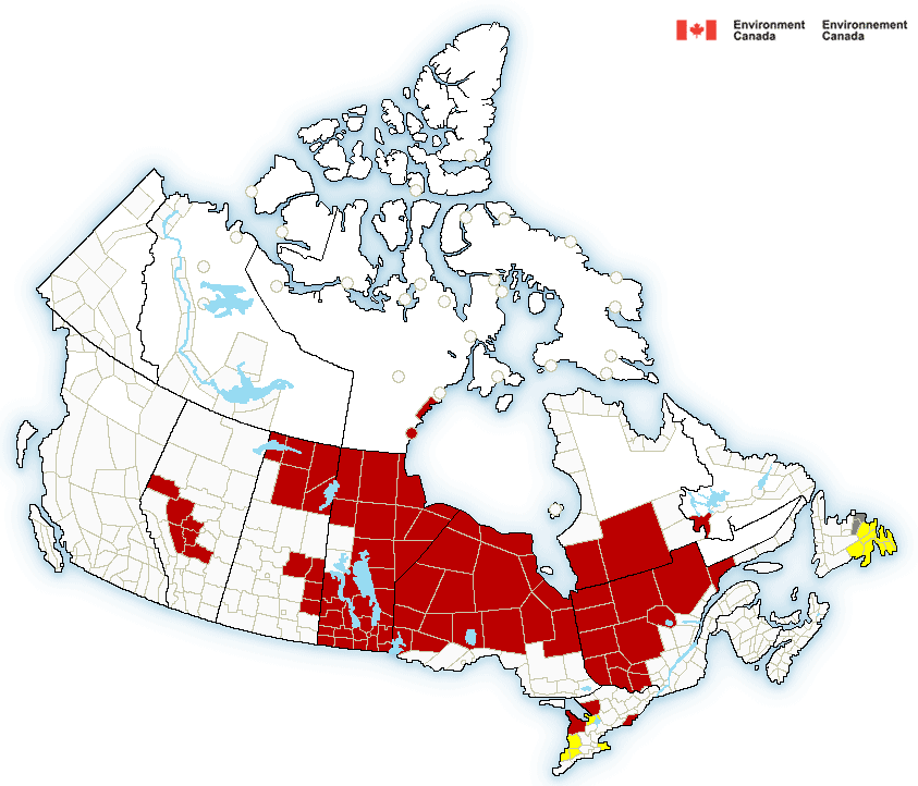
Extreme cold warnings stretch from Manitoba to Labrador (red shading). Those warnings may be extended to southern Ontario and Quebec later today. Snow squall warnings are in effect around the southern Great Lakes.
A frigid polar air mass will engulf eastern Canada and the US over the upcoming weekend. Temperatures will drop into the -20s tonight and not recover much on Saturday. Combined with the cold will be strong northwest winds up to 50km/h in Montreal. Wind-chill values will drop to the low -30s across the region. Extreme cold warnings are in place across a huge area of eastern and central Canada from Manitoba to Labrador. Wind-chill warnings are in effect for most of the northeast US, as well as New England and the Ohio Valley. The extreme cold will be preceded by an arctic cold front today that will produce snow squalls along its path from late today into the overnight hours. A quick 5cm of snow may fall later this evening in Montreal. More snow is forecast along the north shore of Lake Ontario. If your travels take you down Highway 401, expect heavy snow west of Kingston.

Winds will lessen on Sunday, but it will remain cold with early morning lows of -25C (-13F) in Montreal, much colder away from the city. Sunday will be sunny but cold, with a high temperature no better than -15C (5F).

Potential Snowstorm
Looking ahead to next week, temperatures will moderate to near-normal, but there is a chance of snow by Tuesday. Low pressure is forecast to deepen and move from the mid-Mississippi Valley to New England by Wednesday. Depending on the exact track, Montreal may receive in excess of 15cm of snow. Computer forecast models have presented different scenarios ranging from a total miss to rain and temperatures above freezing. I will attempt to fine-tune the forecast over the weekend with updates daily.

Thursday, February 11, 2016

Bitter cold in Montreal and Ottawa through Sunday

Bitter cold air will invade southern Quebec this weekend. Temperatures Saturday and Sunday morning could be as low as -30C.
The temperature is -40C this morning at Eureka, Nunavut, the coldest reading in Canada. In Quebec, it is -35C at La Grande Riviere. That arctic air is heading straight south across the Great Lakes and into southern Quebec, Ontario and the eastern US by Friday. Temperatures this weekend will be the coldest of the winter. We are getting a taste of that cold air this morning. The current temperature is -13C (9F) with persistent light snow that has been around all week in Montreal. Amounts will be light once again today with perhaps a centimetre or two at best. The temperature will not move at all, remaining cold all day with a gusty west wind. On Friday, a clipper-type low-pressure system and arctic front will cross the St. Lawrence Valley late in the day, with some rather robust snow squalls and strong winds. Behind that front, frigid air will pour into the area. Overnight lows by Saturday morning will range from -22 (-8F) to as cold as -30C (-20F) in southern Quebec. Add a light breeze to that and windchill readings could be in the minus 30's. The cold air will remain on Saturday with daytime highs near -19C (-2F) in Montreal.

Sunday will be a little less cold as winds lessen and some sunshine returns. The high temperature will be near -16C (5F). After the mild winter we have had, these temperatures will be bitter and downright dangerous. Prepare to dress warmly and keep your pets indoors, my Bella, apparently needs blankets as well. Looking ahead to next week, we can expect a moderation in temperatures along with a chance for precipitation by Tuesday. Some computer models are hinting at a rather potent storm Tuesday for southern Quebec and eastern Ontario. I will post more on that Friday.

Monday, February 08, 2016

Montreal between storms - frigid by next weekend

NOAA image of the large winter storm off the east coast. The swirl and eye-like cloud structure resemble that of a hurricane.
As has been the case most of this winter, Montreal will remain spectators as another large winter storm moves up the east coast. The system, resembling a hurricane on satellite images this morning, will pass off the coast of New England later today. On Sunday, the storm brought heavy rain and widespread coastal flooding to North Carolina. Today, southern New England, especially Massachusetts, will take the brunt of the storm with blizzard conditions and 100km/h (60 mph) winds. In addition to the heavy snow, waves of over 5 feet and a storm surge will impact coastal areas as far north as Nova Scotia. A blizzard warning has been issued for Nova Scotia where 30cm of snow is forecast, along with winds up to 90km/h (55 mph).

Southern Quebec will remain on the far western edge of the system today, with partly sunny skies and cold northeast winds up to 50km/h. Temperatures will be colder than they have been in some time, with a high of -7C (19F). We will see windchill values in the minus teens. Tonight, a second area of low pressure developing over the Great Lakes will spread an area of light snow into Montreal that will persist into Tuesday. We are expecting less than 5cm total accumulation with perhaps a little blowing snow at times. Temperatures will be cold, with a low of -10C (14F) and a high Tuesday near -5C (21F). By the weekend, the coldest air this winter will pour into southern Quebec with overnight lows in the -20's and daytime highs in the minus teens.

Thursday, February 04, 2016

From snow and ice to a record high for Montreal

Wednesday started off icy and snowy on L'Ile Perrot, and across most of eastern Ontario and southern Quebec, but ended with a record high of 8C. (ValleyWeather)
Within a 24-hour period, Montreal managed 15-20mm of frozen precipitation, ranging from snow to freezing rain and sleet, followed by a record high reached late Wednesday evening. The freezing rain created a very slow and slippery commute in Montreal with numerous accidents reported, including one that closed Highway 20 at St. Charles on the West Island. The high temperature at Trudeau Airport occurred near midnight, 8.2C (48F), eclipsing the 1991 record of 6.2C. The warmth was part of a large storm system that spread north across the central US plains and into western Quebec. The winter storm produced heavy rain and snow along its path, with near-blizzard conditions reported from Minnesota to Colorado. Meanwhile, on the warm side of the system, severe thunderstorms and multiple tornadoes were reported across Mississippi, Alabama and Florida.
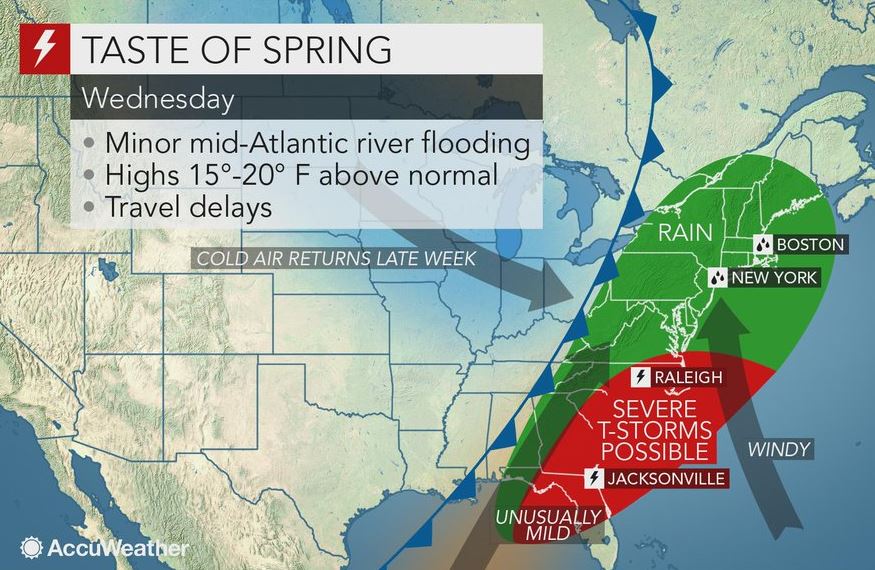
It was not just Montreal benefiting from the warmth yesterday, Burlington, Vermont established a new record high of 54F for February 3rd and 4th, the fifth record high this winter. Toronto soared to 16C (60F), smashing the previous record of 9.3C (49F) set in 1991. Ottawa reached 7.9C (46F), beating the previous high of 6.5C set in 1991. Most locations in eastern Ontario and western Quebec that tied or set new temperature records did so after dark last evening, making it an even stranger weather event.

A cold front will arrive today, resulting in temperatures falling well below freezing tonight and into the weekend. Along with the colder temperatures, there will be several opportunities for snow, the first, Saturday evening. None of the storms at this time look significant, but we are watching an east coast system for the middle of next week to see just how close it comes to southern Quebec.

Tuesday, February 02, 2016

Early Spring - Happy Groundhog Day!

7AM UPDATE: Shubenacadie Sam did not see his shadow this morning in Nova Scotia and is predicting an early Spring.

If Candlemas be fair and bright, 
Winter has another flight.
If Candlemas brings clouds and rain, 
Winter will not come again

Tuesday, February 2nd is Groundhog Day across North America, the midway point between the Winter Solstice and the Spring Equinox. I love the day because, at the very least, it brings everyone into my weather circle for just a few moments. Groundhog Day can trace its humble beginning to Germany in the 1700s and the Festival of Candlemas The superstition stated that if the weather was sunny on Candlemas, February 2ndone could expect six more weeks of winter; if cloudy, an early spring would occur.

The origins of the day in North America date as far back as 1887. In Pennsylvania, German settlers thought that if the sun made an appearance on Candlemas Day, an animal would cast a shadow, predicting six more weeks of winter. The Germans watched a badger for the shadow, however in Pennsylvania, the groundhog was selected as the replacement.

Nowadays, we have numerous groundhogs across North America who claim weather supremacy. Wiarton Willie in Ontario, Shubenacadie Sam in Nova Scotia and Punxsawtawney Phil in Pennsylvania remain the most popular. As we wait for this year`s predictions, think about the quote on Phil's accuracy via Inner Circle VP and handler Mike Johnston, "He is not burdened with the necessity to be site-specific. So Phil's predictions are unquestionably accurate.” Well, in reality, according to Stormfax.comPhil has an accuracy rating of 39% over the years and has seen his shadow 87% of the time. I have never thought of the day as holding any scientific accuracy, but I love the fanfare just the same.  In any event, shadow or now shadow, as Canadians, either way would be a bonus for us here in Montreal. If winter ended in six weeks, that would be about four weeks ahead of normal! Canadians are all too familiar with how harsh the weather can be at the end of March and start of April. 

For a more informed and scientific opinion I turn to the monthly Environment Canada media bulletin for January 2016, and meteorologist Andre Cantin who stated, Will we have an early spring? It is early to say categorically, but the probabilities are in our favour because, in the past, most winters influenced by El Niño have ended earlier than average. However, Mother Nature can always surprise us with major spring storms. Do not put your shovels away too soon!! 

Monday, February 01, 2016

Warm & wet start to February

Mild air and rain will return once again by Wednesday in Montreal.

After a rainy and very mild Sunday, record high temperatures have already been established this morning in Toronto, 10.4C (51F) and Burlington, Vermont at 11C (52F). Close to home, St Anicet reached 11.1C (52F) in the pre-dawn hours, shattering their record of 5.5C from 2002. We managed 9.4C (49F) here on L'Ile Perrot and 8C (48F) at Trudeau, just a notch below the record high of 10.3C set in 1988. The normal high should be -5C (23F). We have likely reached the daytime highs for the day, as a cold front is about to move into eastern Ontario and southern Quebec. Gusty winds up to 60km/h are possible up to the noon hour today in the St. Lawrence Valley, along with falling temperatures back to the freezing point by later this afternoon. Some showers are possible, but it will be dry for most of the day.

Tonight will be partly cloudy and much colder as high pressure briefly nudges into the area. Temperatures will drop to -9C (16F), so Tuesday morning will feel very different from this morning. Tuesday is also Groundhog Day, when furry rodents all over North America take over the forecasting duties. More on that later today.  After a sunny day on Tuesday with a high of -3C (27F), our attention will turn to a developing storm over the US Rockies. This strengthening system will move towards the Great Lakes and eventually western Quebec. Another surge of moisture and mild air will arrive late Tuesday night and early Wednesday. At this time, we are expecting a snow and rain mix to transition to all rain by Wednesday as temperatures rise well above freezing. The timing and any possible problems with freezing rain still have to be ironed out. I will post an update on this storm later today. By the end of the week, much colder air will return with a few flurries.