Friday, July 01, 2016

Mother Nature provides the fireworks for Canada Day

Happy Canada Day. Clouds will increase across southern Quebec today with thunderstorms likely this evening. 
High pressure is in control of the weather across southern Quebec this morning. After a very pleasant Thursday, Canada Day Friday is shaping up to be sunny and warm with a high temperature near 28C (83F) for Montreal. A rather vigorous cold front over the Great Lakes will sweep into the St. Lawrence Valley this afternoon and evening along with showers and thunderstorms. Like Tuesday afternoon, some of the storms may be locally severe with gusty winds, small hail and heavy rain possible. The thunderstorms on Tuesday produced severe weather in extreme southern Quebec with 100km/h winds reported along the US border in Huntingdon. Strong storms also affected Morin Heights where trees were toppled, and 17,000 Hydro Quebec customers left without power. In Montreal, and here on L'Ile Perrot, we had lots of lightning and much needed rainfall, with 12 to 20mm reported.

Today's storms will develop over Eastern Ontario and the Adirondacks of New York early in the afternoon and move rapidly northeast into southern Quebec by 4 or 5pm. Severe thunderstorm watches may be likely for part of the region late today, so have an eye on the sky as you take part in the many scheduled Canada Day activities. The showers will taper off after midnight as cooler air arrives from the west. Overnight lows will drop into the upper teens, with a high on Saturday near 21C (70F). Saturday  will be partly cloudy, with some showers still around. High pressure arrives Sunday with sunshine and dry weather expected to last well into next week. Temperatures will warm daily from 26C (79F) Sunday, up to 30C (86F) by the middle of next week.

Funnel cloud and possible tornado near Ponoka, Alberta late Thursday afternoon (CBC News)
Alberta Tornado
Strong thunderstorms swept across central Alberta on Thursday, with hail, fierce winds and possible tornadoes. One funnel clouds produced damage near Ponoka, Alberta south of Edmonton, just missing a packed fairground. No injuries were reported. Environment Canada will be investigating the damage today to determine if a tornado did touch down.

Tuesday, June 28, 2016

Strong thunderstorms possible for southern Quebec

Montreal remains abnormally dry, with most vegetation now showing some signs of heat stress and lack of water. Southern Ontario and parts of the Northeast US are in a moderate drought. (AccuWeather)
Our current stretch of warm and humid weather is about to come to an end. Twin cold fronts lie just to the northwest of Montreal this morning, with showers and thunderstorms expected to develop along them today. Some of the storms may be strong to locally severe, with heavy rain, gusty winds and small hail possible, especially from Montreal south and east into the Townships and New England. Thunderstorms are forecast to develop around noon in Montreal and last through sunset.

Montreal is very warm this morning, with a mild overnight low of 22C (72F). Limited sunshine today should keep the temperature down to 25C (77F). We managed a high of 28C (83F) Monday, despite the clouds and early showers. Montreal has already recorded five 30C-or-warmer days at Trudeau Airport. We did not record a 30C high in Montreal until July 7 during the summer of 2015. Today's cold front will usher in a slightly cooler air mass for Wednesday, with expected high temperatures in the low 20's accompanied by a shower or two. High pressure will clear skies along with a warming trend for Thursday and Canada Day. Look for wall-to-wall sunshine to start the holiday weekend, with highs near 27C (81F). At this time, a few showers are forecast on Saturday, but I am not overly confident with that forecast.

Conditions remain very dry across the region, with slight-to-moderate drought being reported from southern Ontario into Quebec and New England. According to the United States Drought Monitor, many Northeast and southern St. Lawrence Valley locations are reporting only 25 to 50 percent of normal rainfall.

EF2 Tornado
Environment Canada has confirmed the second tornado of the year for Quebec. It occurred on a very warm and humid June 20th in Lac Verne. The EF2 tornado, with an estimated 190km/h winds, destroyed a cottage and knocked down a strand of trees. Two people were seriously injured in the storm. Quebec records an average of 6 tornadoes a year. (The Enhance Fujita Scale rates tornadoes from EF0, the weakest, to EF5, the strongest).

Saturday, June 25, 2016

Perfect weather weekend for Quebec and Ontario - historic West Virginia flooding

Catastrophic flash flooding in West Virginia has resulted in at least 23 deaths. 
(NBC News)
For the second weekend in a row, high pressure is in control of our weather across southern Quebec, Ontario and New England. Sunshine will dominate, with just a few afternoon clouds. Temperatures will be very warm once again, rising up to 30C (86F). Overnight lows will be comfortable, around 17C (63F). A frontal system will bring us some showers on Monday, along with slightly cooler weather. More showers and thunderstorms are expected Tuesday, before skies clear Wednesday. Temperatures will warm up again as we approach the Canada Day long weekend.

MODERATE DROUGHT
Speaking of rain showers, moisture is badly needed. Moderate drought conditions prevail across the entire region. Most locations have reported consecutive months of less than 50 percent of the normal precipitation. Stream flows and water levels are dropping. The Rideau Valley Conservation Authority is reporting the Rideau River in eastern Ontario is flowing at only 15 percent of normal for this time of year. Fire conditions remain elevated across southern Quebec and Ontario. Several grass fires were reported in Eastern Ontario last week. Even with rain in the forecast early next week, conditions are expected to remain excessively dry. Vegetation is beginning to show signs of drought as well. Water conservation is strongly suggested in eastern Ontario and southern Quebec, but has not been formally ordered at this time.

WEST VIRGINIA FLOODING
The high pressure giving Montreal our beautiful weather, has deflected a potent area of showers and thunderstorms south of the Great Lakes into the Ohio Valley. Violent weather with tornadoes and powerful thunderstorms swept across portions of Illinois and Indiana, into the central Appalachians Thursday and Friday. In West Virginia, three month`s worth of rain fell in just a few hours. Some locations in the state received over 250mm (10 inches) of rain. Widespread, severe flash flooding occurred with swollen rives and creeks washing away homes and cars. This is the worst flooding in over a century in that state, with reports of at least 23 fatalities. Over 500,000 utility customers were without power at the height of the storms. The West Virginia National Guard has been deployed, with numerous water rescues and evacuations required. The rain has stopped for the time being, with water levels slowly receding. This has allowed the clean-up to begin, and the search for more victims to continue.

Tuesday, June 21, 2016

Record warmth for Montreal

Hydro Quebec is currently restoring power to more than 200,000 customers, down from 300,000 last evening. The utility said most of the outages were caused by trees making contact with lines and a few others by lightning. (Hydro Quebec Photo)
The sweltering heat of Monday has been replaced by natural air conditioning this morning, as temperatures have settled back into the high teens in Quebec. Montreal at 7:00 am was 19C (66F), after a record high of 32.9C (91F) on Monday afternoon. Numerous other record-high temperatures were tied or broken from Ontario to Newfoundland. The cooler weather this morning is thanks to a cold front that moved across Ontario and Quebec last evening. The front generated widespread severe thunderstorms. The fast-moving line of storms produced hail, wind gusts to 90km/h, as well as some tornadic rotation. Tornado warnings were issued by Environment Canada around 7:00 pm for portions of eastern Ontario, including Ottawa. No tornadoes were observed.

The storms skipped my location here on L'Ile Perrot, moving just to the north. We had several hours of vivid lightning, but no rain. Strong winds produced by the storms cut power to nearly 300,000 Hydro Quebec customers, most of those in the Quebec City region. Power outages were also reported in Ontario, New York and Vermont. A number of trees and branches were down as well, several on cars and homes in both Ontario and Quebec. All this on the first official day of summer.

Record warmth provided the fuel for late afternoon and evening thunderstorms in Ontario and Quebec. (Valley Weather Photo)
The cooler and less humid air mass will be with us for a couple of days here in Montreal, before temperatures begin to climb again into the upcoming long weekend. Highs today through Thursday will be around 24C (76F), with pleasant lows near 15C (59F). There is a risk of some showers late today and again Wednesday. By the weekend, Montreal can expect an increase in humidity, along with highs nearing 30C (86F) once again.

Monday, June 20, 2016

Summer arrives today, with heat and thunderstorms

The annual car show in Sainte-Anne-de-Bellevue benefited from spectacular weather on Saturday. Huge crowds viewed hundreds of classic cars. Sunshine with near record high temperatures occurred all weekend across southern Quebec.
(Valley Weather Photo)

It is a hot morning across southern Quebec and Ontario on this last day of spring, first day of summer. The solstice, accompanied by a full strawberry moon, occurs today, with summer officially arriving at 6:34 pm. Today will feature almost 16 hours of daylight. We also have very active weather expected today, as a strong cold front pierces through the heat and humidity. We started very warm this morning, 9am temperatures were already pushing 27C (80F) around the region. Highs should settle into the 32C (90F) range, with humidex values approaching 40C (104F) this afternoon. Montreal has an outside shot at the record high for the date, 32.7C (91F) set in 2012. Environment Canada has posted a heat advisory for much of eastern Ontario and southwest Quebec, including metro Montreal.

Gusty southwest winds will be a factor today. Winds are already increasing this morning, with forecast speeds up to 60km/h expected this afternoon, and 80km/h this evening. In addition to the wind, we can expect thunderstorms to develop along a potent cold front after 5pm in Montreal. Some of the storms may become severe, with strong damaging winds and possibly hail. Once the front clears the St. Lawrence Valley overnight, we can expect cooler weather, with lows dropping to 18C (65F), and highs near 23C (73F) on Tuesday, under partly cloudy skies.

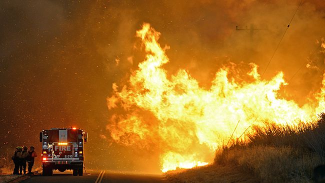
Searing heat in the southwestern US has lead to widespread brush fires in Arizona and California, along with multiple weather-related fatalities. (AP Photo)
SOUTHWEST US HEATWAVE
While Montreal basked in near-perfect summer weather over the weekend, strong thunderstorms occurred over western Canada. Several tornadoes were reported in Saskatchewan, with minor damage but no injuries. Searing heat impacted the southwest US, with high temperatures in Phoenix and Las Vegas rising into the middle 40's. Phoenix recorded that city's 5th all-time warmest temperature on Saturday, establishing a new record high at 47C (118F). Four deaths were blamed on the heat, along with widespread wildfires.

Friday, June 17, 2016

Warm, dry weather increases fire risk in Quebec

According to SOPFEU, extreme fire conditions (in red) cover most of the province of Quebec. A fire ban has been put in place for those regions, and may be extended south into Montreal and extreme southwest Quebec (yellow).
Southern Quebec is into a prolonged stretch of warm and dry weather, after a cool start to June. Temperatures across the southern portion of the province have been in the high 20s and are expected to rise into the low 30s this weekend. With low humidity forecast, the forest fire risk in on the rise. According to SOPFEU, the provincial forest fire-fighting agency, two thirds of Quebec, excluding Montreal and the US border regions at this time, is under extreme fire conditions. SOPFEU announced earlier Friday that all outdoor burning is prohibited, including campfires, until further notice.

The burn ban could likely be extended to Montreal this weekend. Rainfall has been sparse this spring, with only half the normal precipitation since May 1st. Montreal has recorded 46.4mm of rain to date for June, but 32mm of that occurred on one day.

Strong high pressure continues to dominate the weather in Montreal, with sunshine, warm days and cool nights. High temperatures will range from 29C to 32C  (80-85F) this weekend. Overnight lows will be seasonable, down to 13C to 15C (55-60F). No precipitation is expected at this time. Monday will be sunny and hot, with an increase in southerly winds driving up the humidity. A cold front arrives late in the day, with showers and thunderstorms overnight into Tuesday. Expect sunshine and seasonable weather to return by Wednesday.

Monday, June 13, 2016

Lightning 101

A late afternoon lightning strike in Kemptville, Ontario. (ValleyWeather Photo)
June 13 -19 is lightning safety week in Canada.

Summer weather means heat and humidity in Montreal, and along with that comes the ever-present risk of thunderstorms. Thunderstorms produce a variety of nasty by-products including hail, high winds, flooding and even tornadoes. However one of the biggest killers during thunderstorms in North America is lightning. On average, a lighting strike occurs every three seconds in Canada during the summer months of June trough August. At any given second, lightning is striking the earth somewhere. Nearly 2000 thunderstorms are active around the earth every minute! Lightning is responsible for numerous deaths and injuries, and significant damage to homes, electrical devices and power grids. Nearly 45 percent of forest fires in Canada are started by lightning.

You should know that there is no safe place outdoors during a thunderstorm; your best defence is to get inside. While your chances of being struck by lightning are statistically slim, in an average year, ten Canadians pay the ultimate price for taking the gamble. Another 150 to 160 are injured, some with injuries that will have lifelong repercussions. The average bolt of lightning contains 300 million volts, enough energy to light a 100-watt incandescent light bulb for about three months. The air displaced by lightning is heated to nearly 28,000C (50,000F), a temperature five times that of the sun and hot enough to melt car tires and burn skin. If you are stuck outside, get as low as you can, make yourself as small as possible.

One of the myths about lightning is that it never strikes the same place twice. The Empire State building in New York City is struck an average of over 100 times each year. Likewise, the CN Tower in Toronto, Ontario is struck several times each year. Lightning likes tall objects. Stay away from trees. Most thunderstorm-related deaths across North America are from those who seek shelter under a tree during a thunderstorm. It is one of the worst places
you can put yourself, another being anywhere on or near water. Head ashore as soon as threatening weather approaches. You should always know the risk of thunderstorms when boating or at the beach. Keep a weatheradio with you at all times. They are inexpensive and could be a lifesaver.  Alternately, you can download one of the weather apps for your smartphone. Environment Canada monitors lightning strikes across Canada, and displays the information at http://weather.gc.ca/lightning/ updated every 10 minutes. Know the risks, plan and prepare to take shelter. This is especially true during outdoor events including baseball, soccer and concerts.

Lightning can strike more than 5km from the parent storm, so as soon as you hear thunder, head indoors. Refrain from outdoor activities such as swimming, soccer or golfing for at least 30 minutes after the last thunder occurs. A recent study by Environment Canada indicated that as little as 3-5% of individuals injured or killed by lightning in Canada are victims of a direct hit. Most hits occur by ground current (40-50%) or side flash (20-30%). That is why it is so important to refrain from using electrical appliances such as phones or computers that are hardwired directly to your home. Cordless items are fine to use.

You are relatively safe inside a car. However, if a car is directly hit, significant damage, including fire and blown out windows can occur. Another popular myth is that people struck by lightning can’t be touched. A person struck by lightning is safe to handle immediately after the hit. They may need CPR or other medical attention. You should call 911 without delay.

Thursday, June 09, 2016

Showers for the Grand Prix weekend in Montreal

Rain in 2011 made for a very exciting Canadian Grand Prix, if you were watching from the comfort of your couch. It will be showery and cool at the drop of the green flag this year, but it should not be a washout.
The Formula 1 Canadian Grand Prix is this weekend at Circuit Gilles-Villeneuve in Montreal. Tens of thousands of race fans and team members will pour into the city for the annual event, all hoping for good weather. There is some good news and bad news for the upcoming race weekend.

Thursday morning, deep low pressure, along with the remains of tropical storm Colin, continues to pull away to the northeast out into the Atlantic. The broad circulation around these features will continue to pull down unseasonably cold and unstable air into southern Quebec and New England. The result is an October-like morning in Montreal, with a low temperature of 8C (48F) along with gusty northwest winds. The weather will remain cloudy and cool today, with gusty unpleasant winds up to 60km/h and occasional showers. The temperature will struggle to reach 16C (60F). At present, Friday looks much better, as the aforementioned low releases its grip and high pressure arrives from the Great Lakes. Sunshine will prevail and the mercury will respond, rising into the middle 20's (24C/75F). So far Saturday looks decent in the morning, before clouds and perhaps some showers and thunderstorms arrive for the afternoon, as yet another cold front moves in. The high will be 21C (70F). The front will leave behind a cool and blustery race day Sunday in Montreal. Expect mostly cloudy conditions, some showers, and temperatures well below normal at 16C (60F). If the rain stays away, the cooler weather will actually be better for race fans and drivers alike.

A veiled view of Mount Washington in New Hampshire this morning showing a wintry landscape in June. (MWOBS via Twitter)
JUNE SNOW
How cold is it this morning across our region? The current temperature is only 4C (39F) in St Agathe, north of Montreal, with most other locations in the 6C to 10C (43 to 50F) range. On the summit of Mount Washington in New Hampshire, the current temperature is -4C (25F), along with snow and sleet and a northwest wind of 122km/h gusting to 135km/h (76mph gusts to 84mph). The windchill is -17C (1F). It certainly does not feel like June!

Monday, June 06, 2016

Cool wet week ahead for southern Quebec

A deluge of rain fell quickly on Sunday, with 25 to 50mm (1 to 2 inches) occurring in eastern Ontario (Cornwall shown above), as well as southern Quebec and New England. Most of the rain fell between 11am and midnight.
More rain fell in the last 24 hours in southern Quebec than in the entire month of May. The rain was desperately needed, as most regions were well below normal, with some areas reporting less than 50 percent of the normal precipitation this spring. At Trudeau Airport, 32mm of rain fell, with close to 30mm here on L'Ile Perrot. The rain was quite heavy at times and accompanied by thunder and lightning, especially overnight. In Ottawa, and across eastern Ontario, the weather was much the same, with 36.4mm falling in the nation's capital in less than 12 hours. Ottawa had only received 26.2mm of rain in May. Unfortunately, the rain fell on a busy summer weekend, which included a soggy Tour de L'Ile here in Montreal. The 20,000 cyclists started off the 65 to 100km route in cloudy but dry weather. That quickly changed by mid-morning, as heavy rain arrived from the southwest. The event still concluded as scheduled, with no incidents reported.

This morning, Montreal is mild but damp, with lots of moisture left over. Some sunshine today will help to generate afternoon clouds and perhaps a shower or thunderstorm. Temperatures will be mild, near 24C (76F). Tuesday through Thursday will be quite unsettled, with plenty of clouds and showers, along with much cooler temperatures. After the low 20's on Tuesday, Montreal will only reach 15C (59F) Wednesday and Thursday, before temperatures slowly moderate late in the week. If you don't like the heat, then enjoy this respite from the hot weather, as we expect it to return by the third week of June.

TROPICAL STORM COLIN
The third tropical system of this young 2016 season formed late Sunday in the Gulf of Mexico. Tropical storm Colin was located 580 km (360 miles) west southwest of Tampa, Florida at 5am, with 85 km/h (50 mph) winds. The storm will rapidly move northeast today and reach the coast of Florida, in the Big Bend region, by Monday evening. The biggest threat from Colin will be torrential rains falling on the saturated southeast US. Flooding is likely, especially across the coastal Carolina's, which were impacted by Bonnie last week.

Friday, June 03, 2016

Pattern change ahead for Montreal and eastern Ontario

A 50/50 weekend is expected in Montreal and eastern Ontario. Sunny and warm on Saturday, followed by a rainy Sunday.
Southern Quebec received some much-needed rainfall on Thursday, as a slow-moving cold front crossed the St. Lawrence Valley. Close to 8mm of rain fell across the city, the most on any one day since May 8. Sunshine returns today, along with warm temperatures which will remain through Saturday. Expect high temperatures near 27C (80F) and overnight lows around 16C (60F).

Our great stretch of weather will come to an end on Sunday, as high pressure builds in western Canada and a trough develops over the Great Lakes. Low pressure will move across the region Sunday, with a soaking rain. At this time, it looks like 15-25mm, or up to one inch, of rain is possible in Montreal. Temperatures will be cooler, but still near normal, 22C (72F). Cloudy skies and cooler temperatures will remain in southern Quebec to start the week, likely lasting through Wednesday. Sunshine is expected to return by next Thursday.

Major flooding continues to unfold in Texas. Massive evacuations have been necessary, with widespread damage in and around Houston. At least six fatalities occurred on Thursday alone. Above, record flooding in Fort Bend County, Texas. (AP Photo)
The weather remains very wet across the southern US, with historic flooding in Texas. At the same time, the remnants of tropical storm Bonnie crossed eastern North Carolina with flooding there as well. Here at home, much warmer temperatures will be developing over western Canada, with a return to the upper 20's and low 30's expected in Alberta and Saskatchewan. Winter cold is holding on in parts of Newfoundland and Labrador, where a widespread frost occurred Thursday. A new record low of -6.9C (19F) was set at Churchill Falls, Labrador. The previous low was -4.1 (24F) set in 1992.

Wednesday, June 01, 2016

Welcome to meteorological summer in Montreal

Slightly-cooler and less-humid air has arrived on northeast winds in Montreal. A much-needed general rainfall is expected early next week across eastern Ontario and southwest Quebec. (AccuWeather)
The official start of summer is still three weeks away, on June 20 at 6:34am, at least according to the planets. Today however, we welcome meteorological summer. Weather forecasters and nerds like myself must have things in neat little compartments when it comes to statistics, so the year is divided into 4 seasons, each consisting of 3 months. Welcome to June, July and August, summer 2016 in Montreal.

It certainly has felt like summer over the last week, after a very slow start to spring. We remain sunny and warm today at 26C (79F), but very dry in southern Quebec. Montreal received only 33.6mm pf rain for the month of May, way below the normal of 82mm. We also had a trace of snow for good measure. It is exceptionally dry, and many regions of southern Quebec, Ontario and New England are asking residents to conserve water. Also, outdoor fires are becoming problematic in extreme southern Quebec, where the fire risk remains elevated. This, hopefully will change during the next week or so, as cooler weather and rain are expected in Quebec from Sunday into early next week. We have a chance of showers along a cold front Thursday and Friday, but they will be spotty. Temperatures will remain rather warm, 25C (77F). The cooler weather and rain will arrive Sunday. That scenario is still a few days out, and the forecast will likely require some fine tuning as we get closer.

Monday, May 30, 2016

Record warmth in Ontario and Quebec plus tropical storm Bonnie

After the record warmth, strong thunderstorms moved across northwest Vermont on Sunday. (WCAX TV)
It is Memorial Day south of the border on this Monday, typically the "official/unofficial" start of summer. The weekend featured weather extremes across eastern and central North America, with searing heat, severe thunderstorms and tornadoes, and even a tropical storm for good measure. Record warmth surged into the Great Lakes and Quebec with dozens of new record highs established. Notables included Montreal, 31.7C (89F) on Friday, surpassing the record of 30.4C (86F) from 1978. Montreal managed 28C (83F) both Saturday and Sunday, with a slight northeast breeze keeping us a little cooler. On Sunday, Ottawa reached 33.2C (91F), breaking the old record of 31.4C from 1978. It was so hot in Burlington, Vermont on Sunday, organizers were forced to call off the Vermont City Marathon after runners were already on the course, four hours into the event. It was the first cancellation in the marathon's 28 year history. Several participants were treated for heat-related issues. However, many refused to stop and completed the event.

In the late afternoon, strong thunderstorms developed over eastern New York and impacted the northern Champlain Valley as far north as extreme southern Quebec. Wind damage and flooding was reported in St. Albans, Vermont. Only a few rumbles of thunder and less than 2mm of rain occurred in Montreal. We are very dry, with only a paltry 32mm of rain for the month of May in and around Montreal.

Tropical storm Bonnie produced heavy rain across coastal South Carolina on Sunday.
Also this weekend, tropical storm Bonnie developed off the Florida coast and moved northwest into South Carolina. The storm produced widespread heavy rain and flooding in coastal North and South Carolina. Bonnie has since been downgraded to a depression and is located 60 miles southwest of Myrtle Beach Monday morning. Maximum winds were around 30mph. The biggest threat from Bonnie this week will be rough surf, and up to 3 inches (75mm) of additional rainfall from North Carolina into the middle Atlantic sates.

Thursday, May 26, 2016

Summer weather continues in Ontario and Quebec

Warm and humid weather will develop late today and continue into the weekend in Montreal. (AccuWeather)
After a dismal April and start to May in Montreal and most of eastern Canada, the weather is beginning to improve. Sunshine will prevail in Montreal today with a warm high of 26C (79F). A warm front to our southwest will push into the St. Lawrence Valley Friday, with breezy and very warm weather. Temperatures will reach 30C (86F) across a wide area of southern and eastern Ontario and southern Quebec. Along with the warmth will be an increase in humidity and the possibility of showers and thunderstorms. Those conditions will prevail Saturday as well and perhaps into Sunday.

Rain is needed here in Montreal. The city has only recorded 31mm of rainfall this month, while the normal should be 81.2mm. Most of that precipitation fell in the first 15 days of May, with only a trace since. Outdoor conditions remain very dry in Quebec forests, and burning is not advised. The same is true for eastern Ontario, where several watersheds are reporting minor drought conditions.

AccuWeather storm chaser, Brandon Sullivan, captures a spectacular shot of one of the many tornadoes that formed near Dodge City, Kansas on Tuesday, May 24.
Increased heat and humidity created perfect conditions for severe thunderstorms and tornadoes. The central and southern US plains reported dozens of them on Tuesday and Wednesday, including several large wedge tornadoes in Kansas. Widespread damage occurred, with at least one fatality.

Tropical Storm Bonnie?
The tropical Atlantic is coming to life as well, with the potential development of a low pressure east of Florida. Forecasters at the National Hurricane Center are watching an area of disturbed weather a few hundred miles northeast of the Bahamas. If the system continues to develop, it could become a tropical storm by this busy Memorial Day Weekend. The storm has the potential to impact parts of the southeast and middle Atlantic US into the weekend. Hurricane season typical runs from June 1 to November 30. I was reminded yesterday, by meteorologist Steve Glazier with WPEC in Florida, that this would be the second storm of the year, Bonnie. I had forgotten about the very rare tropical storm Alex, that formed back on January 14 near the Azores. Yet another unusual weather occurrence this year.

Tuesday, May 24, 2016

Warm forecast for Montreal

While Montreal enjoyed a spectacular long weekend, snow fell across southern Alberta including Calgary, shown above.
A warm, southerly flow of air continues to impact southern Quebec with above-normal temperatures. This past holiday weekend, the temperature was warmer in Montreal than most of the US east coast. High pressure will continue to provide sunshine and warm temperatures today, with a high near 29C (85F). Temperatures will remain mild tonight, dropping only to 17C (63F) under fair skies.

The balance of the week will feature a storm system moving along the US east coast, with much cooler air and showers in place to our east. A backdoor cold front will become established southeast of Montreal, with showers and thunderstorms developing along it. The weather will remain very warm west of the front and much cooler to the east. The humidity will increase as the week moves along. I believe Montreal will remain on the warm side of the front, with temperatures above normal. Highs will reach into the upper 20's (low 80's) and low temperatures will remain in the teens (low 60's).

With the extended period of warm and dry weather here, outdoor burning should be avoided. The fire risk for most of southern Quebec is elevated at this time. Currently, there are six active fires in the province. The year to date has seen 187 fires, above the ten year average of 176. The good news is that the fires have been managed, and the total amount of hectares burned is down.

Sunday, May 22, 2016

Summer warmth on the way

Much warmer air will surge into the St. Lawrence Valley this week, with highs reaching the upper 20's.
I'm back! After taking a week break in coastal New England and Boston, it is back to the daily grind. What a weather week we had across North America as the bizarre spring of 2016 continues to unfold. I was in Hampton Beach, New Hampshire, where the week started off and ended sunny and warm. In between, the weather seemed to change every five minutes. Such was the case across southern Quebec and Ontario as well, as extremely cold air swept across the region last Sunday and into the middle part of the work week. Snow fell across large portions of Quebec, including scattered flurries in Montreal early Monday morning, May 16.

The good news is we appear to have turned a corner. Indications are that a major pattern shift is underway that will lead to summer-like warmth to end the month. We are already seeing warmer weather this weekend, with high temperatures either side of 25C (77F). The only twist in the forecast this weekend so far, is coastal low pressure near Cape Cod. It has produced more clouds than sun for Sunday here in the St. Lawrence Valley, along with the outside chance of a shower or thunderstorm. The start of this upcoming week in Montreal will be sunny and warm. Conditions will become more humid by Wednesday, with perhaps some showers or thunderstorms. Temperatures will remain above the normal of 21C (70F) all week. A nice change from spring so far.

Friday, May 13, 2016

One last cold weekend of the season for Montreal

WINTER JUST WON'T LEAVE: A late season snow fell across the foothills of the Rockies in southern Alberta on Friday.(CBC Calgary)
The weather roller coaster we have been on over the last month here in Montreal, will take one more dip this weekend before mild air returns. The warm air of Thursday was replaced by clouds and showers Friday, as a cold front swept across southern Quebec. An upper level low pressure system, spinning north of the Great Lakes, will send another stronger cold front across the region Saturday. Temperatures will cool down rapidly behind the front Saturday night, and only rise to 7C (45F) on Sunday, about 12 degrees below normal. The front will be accompanied by showers and thunderstorms and then followed by gusty and cold northwest winds. The good news is that the cold air will be around for less than 48 hours before a warming trend begins Tuesday. Milder air will return over the course of the upcoming week and remain in place for the first official long weekend of the summer.

The cold air has prompted frost warnings across a large portion of the upper Midwest into central Ontario. Snow is even in the forecast for far northern Ontario and northwestern Quebec, close to Hudson Bay. The cold air may even produce some flurries across the highest elevations of southern Quebec and northern New England by Sunday morning.

Thursday, May 12, 2016

Montreal's warmest day yet in 2016 forecast for Thursday

POOR TIMING: The warmest day of the year in Montreal on Thursday, will be followed by more cool, showery weather for the weekend. (AccuWeather image)
Thursday will be the warmest day of 2016 to date. Granted, the bar has not been set very high, but we are looking at sunshine and likely our first 27C (80F) day, of the year. We start off this Thursday much warmer than it has been this week, already at 12C (54F) here on L'Ile Perrot. High pressure will dominate the day with light winds and bright sunshine.

That is the good news, and I should probably stop now. As I have mentioned before, spring is a highly changeable time of year. And 2016 has been an especially good example. In the last week, snow has fallen across the lower North Shore, while searing heat and intense wildfires have swept portions of western Canada. Now, heavy snow is forecast in Alberta, with snowfall warnings in place for the foothills west of Calgary towards Banff. In addition, strong thunderstorms have produced major flooding and multiple tornadoes over the central and southern US. Dozens of tornadoes occurred in the Monday-through-Wednesday time frame, with fatalities and injuries.

That brings us back to Montreal and southern Quebec. After the warmth of today, a series of cold fronts will impact the region Friday into Saturday. Showers and perhaps some thunderstorms can be expected, before much colder and windy weather arrives on Sunday. Temperatures by Sunday will struggle to reach 10C (50F), with overnight lows near the freezing point by Monday morning in southern Quebec and Ontario. Temperatures will slowly moderate next week, with a much warmer Victoria Day weekend expected at this time.

Monday, May 09, 2016

Cool start - bright week ahead for Montreal

Spectacular footage of a tornado taken by storm chaser Reed Timmer, near Wray, Colorado over the weekend. This is all part of a spring weather pattern that has produced cold weather here in Montreal, as well as snow, record heat, intense wild fires and flooding rains elsewhere.
It was a Jekyll and Hyde weekend in Montreal, with a nearly perfect Saturday followed by a cold and windy Sunday. Saturday was easily the warmest day of 2016, with bright sunshine and temperatures pushing 24C (76F) in many areas of southern Quebec. A strong cold front arrived in the wee hours of Sunday morning, accompanied by a wind shift and rapidly dropping temperatures. High temperatures on Sunday struggled to reach 10C (50F), with most locations remaining in the single digits. Light rain and gusty northwest winds added to the dismal day. This morning it is downright cold for May, with a current reading at 1C (34F). A few flurries have even been reported in the Eastern Townships and the Green Mountains. On Sunday, snow fell across portions of the lower St. Lawrence, with up to 15cm reported in the Saguenay region.

We can expect one more cold day and night here in Montreal before temperatures moderate for the balance of this week. Today will be partly cloudy, with a few afternoon showers and a high near 10C (50F). Overnight will be clear and cold ,with lows dangerously close to the freezing point. Frost advisories, already in effect in Vermont and northern New York, may be required for southern Quebec. Tuesday through Thursday will be sunny and much warmer, with highs near 20C (68F). Unfortunately, it looks like clouds and showers may return for next weekend.

Friday, May 06, 2016

Cool wet weather continues in eastern Canada

Cool and wet weather will persist in eastern North America through mid-May.
A rather large swing in the jet stream is producing below-normal temperatures, along with damp weather here in southern Quebec and most of eastern Canada. The dismal weather is making for a very slow start to spring here in Montreal. April 2016 was the third coldest on record since 1900, only behind 1926 and 1947. We can expect some very slow changes over the next week or so, with milder temperatures by the end of next week. In the short-term, look for a decent Friday and Saturday, with sunshine and milder highs near 19C (66F). The problem will be a persistent northeast wind of 20-40km/h that will make it feel cooler. Sadly, Mother's Day Sunday looks rainy, windy and cool, with a high of only 12C (54F).

A surreal scene Thursday in the Fort McMurray suburb of Beacon Hill, after wildfires destroyed 80 percent of the neighbourhood. You can help at www.redcross.ca (Radio Canada)

Fort McMurray Fire
The same weather setup producing our cool weather, is pumping very warm and dry air into western Canada, leading in part to the perfect fire weather in northern Alberta. The Fort McMurray wildfire has now scorched over 9000 acres, making it one of the biggest in recent memory. The fire remains out of control, despite the efforts of hundreds of firefighters and help pouring in from across the country. The City of Montreal has donated $100,000 dollars to the relief efforts. The Province of Quebec has sent four water bombers along with eight pilots and four mechanics. Over 2000 structures have been damaged or destroyed, and over 80,000 residents remain evacuated. Sadly two fatalities occurred during the evacuation. There is some hope that cooler weather and perhaps some showers will arrive over the weekend and into early next week. This will be welcome relief from the 30 to 35C record heat that has been occurring from northern Alberta into Saskatchewan and southern Manitoba. On Thursday, Winnipeg recorded a record high of 34.9C.

Wednesday, May 04, 2016

Massive wildfire sweeps into Fort McMurray, Alberta

Some of the nearly 80,000 residents evacuated from Fort McMurray, Alberta, had to drive in horrific conditions along Highway 63 on Tuesday. (Photo via Twitter Global News)
Those of us who follow the weather knew the potential was there for a dangerous wildfire season in Canada. With a warm and dry winter in many locations, lots of tinder-dry fuel was present. However, I did not expect it to start with such ferocity and in early May. One of the largest evacuations in Alberta's history was frantically underway on Tuesday, as a massive wildfire swept towards Fort McMurray, 435 km northeast of Edmonton. The fire grew rapidly, in record heat and extreme low relative humidity, to over 6000 acres in less than 24 hours. On Wednesday morning, the fire was heading into downtown Fort McMurray. Numerous businesses and homes have already been lost, as more than 250 firefighters try to battle the enormous blaze. Resources are pouring in from across the country including those from the Canadian Military and Royal Canadian Air Force.

A Super 8 Motel near Fort McMurray, Alberta burns on Tuesday as an extreme wildfire swept into the city. (Photo via Twitter #YMMFIRE)

Weather conditions were perfect for the fire to spread, with a record high of 32.6C (90F) observed on Tuesday. The normal high should be 16C (61F). More record heat is forecast for Wednesday, with increasing winds along an advancing cold front. Unfortunately, with the very low relative humidity, these are ideal burning conditions. On Tuesday, the humidity was as low as 10 per cent. There are fears that large portions of the community may be lost today. Weather conditions will be cooler by Thursday.

In southern Quebec, there are currently no active fires, but the threat remains high north and east of Montreal according to SOPFEU (Société de protection des forêts contre le feu).

Monday, May 02, 2016

Cool, wet start to May in Ontario and Quebec

Multiple low-pressure areas will bring the threat of rain to southern Quebec this week. Temperatures will slowly warm up to normal values. The rain is needed, as conditions have been exceptionally dry with several grass and brush fires being reported in Quebec and New England. The rain has lowered the threat in southern Quebec, but it remains elevated in the Gaspé region.
Despite the arrival of May, it still feels like early April in Montreal. Cool north or northeast winds will continue the damp trend across southern Quebec today. Close to 10mm of rain fell in the city over the last 24 hours. This morning we have cloudy skies, a short break in the rain, and a cool temperature of 7C (45F). Another round of showers is moving northeast from the Ohio Valley, and should arrive this afternoon. The high today will be cool, around 10C (50F).

The good news is we can expect a warming trend for the balance of the week, with temperatures approaching 20C by Friday. It will not be a perfect stretch of weather, with plenty of clouds and showers around. However I think it will be dry a good amount of the time, with appreciable sunny breaks. While May is starting off cool, most forecasters still agree that it will be a warm and dry summer in southern Quebec and Eastern Ontario. As I always say, time will tell.

Thursday, April 28, 2016

So when will it warm up?

April's wide variety of weather can produce everything from dust devils, like the one last week at a ballpark in Lynchburg, Virgnia (shown above), to heavy snowfall, like the snowstorm this week in Newfoundland (below). In addition to the snow, heavy thunderstorms with large hail, flooding and tornadoes have been affecting the central US. Spring is not for the faint of heart, patience is required.
So when will it warm up? I am asked this question without fail several times a day. April can be a daunting month, as we desperately long for summer's warmth. This April has been no exception to the rule, as the cold and warm weather seem to play with us continuously, often in the same day. The month of April is arguably the most volatile month of the year. Deep winter cold often interacts with mid-summer heat, leaving most of us on a weather roller-coaster ride we never wanted to be on. Thunderstorms are just as likely as snowstorms in April. Montreal for example, has had a wide range in temperatures this year, from an overall maximum of 22C (72F) to a minimum of -10C (14F).

CBC Newfoundland 
Often the winter chill can win out, leaving southern Quebec and Ontario with cooler-than-normal weather. This has been the case here in Montreal. As the month draws to a close, the daily average high temperature has been near 9.1C (48F). This is well below the normal high of 11.6C (53F). Overnight lows have been very chilly, especially in the last week, the average this month was -1.3C (29F), while the normal should be plus 1.2C (34F). Overall, the monthly average sits at 3.9C (39F), well below the normal of 6.4C (44F). What makes it feel even colder is the fact that most of this past winter was so warm. Snowfall for April 2016 was 15cm; normally Montreal receives around 13cm.

So when will it warm up?  (There it is again!) Very soon. Montreal is still on track for a very warm summer. The long-range forecast is hinting at well-above-normal temperatures for Quebec and the Northeast US for July though August. In the short term, we have a few more cool days, as strong arctic high pressure controls our weather. Milder air will arrive by Sunday, along with an increase in clouds and some much-needed rainfall. The wet weather and warmer temperatures will continue into the first week of May.

Monday, April 25, 2016

Cool and dry week ahead for southern Quebec

The current storm track should keep Montreal dry all this week, with below-normal temperatures. (AccuWeather)
Strong high pressure continues to provide Montreal and southern Quebec with sunshine, but cool weather as well. Daytime highs have been below normal, either side of 10C (50F), while overnight lows have dropped just below the freezing mark. A warm front to our south is the dividing line between very warm and humid summery air across the Mid-Atlantic states, and the cool weather here in Quebec. That warm front will produce an area of light rain, and even some wet snow, across the Adirondacks and Green Mountains tonight. Light rain is also expected south and west of Kingston, towards Toronto.

In Montreal, however, strong high pressure should hold all this week, with the current forecast looking great. Expect nothing but sunshine today, with a high near 10C (50F). A few clouds may work their way into southern Quebec tonight, but any precipitation should remain south of the US border. The overnight low will be very chilly, dropping to -3C (27F). Any clouds will clear early Tuesday, and we can expect sunshine all day, continuing well into next weekend in Montreal. Temperatures will be cool, ranging from 9 to 12C (49 to 54F), but warming towards the end of the forecast period.

Thursday, April 21, 2016

Battle of the seasons coast to coast in Canada

Spring cleaning is well underway in Montreal. 
The seasons continue a fierce battle over most of Canada, with summery weather on the west coast, a snowstorm in Newfoundland, and everything else in between. The current weather pattern is referred to by meteorologists as an omega block. Strong high pressure nearly stationary over the Great Lakes is holding the rainfall over Texas and the Gulf Coast, while keeping our region sunny and dry. The block will begin to erode slightly over the next 24 hours, as low pressure moves down the St. Lawrence Valley.

We start the morning rather chilly in Montreal at 0C (32F), but temperatures will warm rapidly to 21C (70F) under sunny skies and gusty southwest winds. Clouds will increase tonight, with showers arriving overnight, as low pressure approaches from Ontario. Friday will be windy and warm, with showers and perhaps a thunderstorm in the afternoon. After mild overnight lows near 10C (50F), the high temperature will be near 21C (70F) once again. A cold front arrives late in the day Friday, followed by clearing skies and much cooler weather for the weekend. Temperatures for the weekend will be near 12C (54F) for highs, with lows at or below freezing.

While it may feel like spring in southern Quebec, Newfoundland was blasted by a powerful snowstorm on Wednesday. (CBC Newfoundland)
Winter vs Spring
Winter and Spring continue an epic battle across Canada. On Wednesday, a powerful coastal storm brought widespread blizzard conditions to eastern Newfoundland. Over 40cm of snow fell in and around St John's, while winds gusted in excess of 100km/h. Schools, businesses and roads were closed, along with major delays to road and air travel. At the same time, interior portions of British Columbia were establishing record-high temperatures. Chilliwack, Lytton and Squamish all surpassed 30C (86F). Squamish reached 31.5C (89F) for the warmest temperature in the country, while Eureka in Nunavut was -30.5C (-23F).

Over 40cm of snow along with 100km/h winds made all forms of travel nearly impossible near St John's, Newfoundland on Wednesday. (CBC)
Texas Flooding
Major flooding continues to unfold across south Texas, after nearly 20 inches of rainfall this week. More rain is forecast over the next several days. Catastrophic damage has been reported, along with at least eight fatalities.

Monday, April 18, 2016

Much cooler, wet start to the work week in Montreal

A backdoor cold front is cooling down Quebec and northern New England today, as it slides north to south.
Sunday was as spectacular an April day as you will find. The temperature reached 22C (72F) here in Montreal, easily the warmest day of 2016. Light winds and bright sunshine made the day perfect for anything outdoors. 

A rather gusty, raw northeast wind has developed here in the St. Lawrence Valley overnight, ahead of a backdoor cold front. These type of fronts are quite common in the spring, as cold, maritime air backs down the St. Lawrence Valley. The temperature have fell overnight to 9C (49F), where it will likely stay for most of the day. Showers are also expected by the middle portion of the day. The good news is that the balance of the week looks sunny, with moderating temperatures to above normal, as high pressure takes over once again. The next chance for any precipitation won't come until late Thursday or Friday.

As always, when there is good weather in a portion of the continent, somebody else is having terrible weather. This morning, that would be the central portion of North America from Texas to western Ontario. Heavy rain is falling along the Gulf Coast, with epic amounts reported overnight in Houston. Between 10 and 16 inches of rain fell on the city, with major flash flooding being reported this morning. To the north and west of that storm, heavy snow fell across the Rockies, including metro Denver. Anywhere from one to four feet of wet snow was observed in portions of Wyoming, Colorado and New Mexico.

Major flooding has led to over 60 water rescues this morning in Houston, Texas. Photo via Twitter @livestormsmedia

Friday, April 15, 2016

Perfect spring-weather weekend for Montreal

High pressure will produce a warm weekend in southern Quebec.
We have been waiting a long time for this weather, and it looks like a perfect spring weekend for anything outdoors. The last of the snow has melted and most people are now in the process of taking down temporary shelters and changing out winter tires. Many municipalities have begun sweeping the streets as well, always a good sign that spring is really here. After a rather cold and damp start to April, high pressure is now in control. Sunshine will dominate through late Sunday, along with high temperatures warming from 12C (54F) today up close to 18C (65F) by Sunday in Montreal. Some locations in Ontario and New England may flirt with 21C (70F) on Sunday. Overnight lows will remain at or just slightly below the freezing point. On Monday, a rather weak cold front will settle south across the region from central Quebec. Clouds will increase Monday, along with a chance for showers. Skies will clear Tuesday, with more sunshine and warm temperatures expected through the end of the week.

The weather is not so perfect everywhere. This morning, snow is falling in Halifax, as a coastal system moves into the Atlantic. Snow and freezing rain will spread across portions of Newfoundland later today. Across western Canada, a strong storm system is moving into North Dakota with a cold rain, and even some snow spreading into southern Manitoba and Saskatchewan.

The April 15, 2007 Nor'Easter produced a record snowfall of 20 to 30cm across Ontario and Quebec. I took the photo above in Kemptville, Ontario where I was living at the time.
As a side-note, on this date in 2007, a strong Nor'Easter dumped 22cm of snow on Montreal, a record for the day. The heavy wet snow spread into eastern Ontario as well. Widespread power outages occurred, as strong winds brought down branches. The heavy snow also hit New England, along with major flooding and coastal damage from high waves and surf.

Monday, April 11, 2016

Spring weather, warming trend for southern Quebec

Another round of April snow blanketed Montreal Monday morning. There is a good chance it will be the last snow until next fall, as a major warming trend is forecast.
An interesting blog title, considering it is snowing again this morning in Montreal, on April 11th no less. An elongated warm front has been the focus for mixed precipitation in southern Quebec and Ontario. A couple of centimetres of wet snow fell overnight in Montreal. It has since changed to rain, as temperatures have nudged above the freezing point. The rain will continue most of today, tapering to showers tonight. Warm air will continue to filter into the St. Lawrence Valley today on southwest winds. Expect a high temperature near 8C (48F).

The good news for eastern North America is that a major pattern change is expected this week. There is a good chance this morning's snow will be the last of the season. After a windy and cold Tuesday, with a high of 7C (45F) and a low of -5C (23F), much warmer weather will move into Quebec. Looking ahead, milder-than-normal weather is forecast from Thursday towards the end of the month and into May. In the short term, we are looking at sunny weather developing Wednesday, with warming temperatures. The sunshine will prevail into the weekend, with high temperatures between 15C and 20C (60 to 68F) by Saturday. Low temperatures are forecast to remain above freezing after Tuesday.

AccuWeather.com

Thursday, April 07, 2016

Spring snow, now heavy rain forecast for Montreal

A spring snow covers southern Quebec this morning, after 10 to 12cm overnight.
Heavy wet snow fell across eastern Ontario and southern Quebec late Wednesday and overnight, with a record-breaking 14.2cm in Ottawa. The previous record for April 6 was 13cm in 1958. Officially, Trudeau Airport reported 10.4cm, so our record of 18.3cm, also from 1958, was safe. I measured close to 12.5cm (5 inches) of snow here on L'Ile Perrot. Overnight, temperatures slowly nudged above the freezing mark, with precipitation changing to rain in Montreal. Temperatures will continue to rise today on warmer southeast winds, with a high forecast of 9C (48F).

Heavy Rain Warning
Low pressure will move from the central Great Lakes towards Lac Saint-Jean by Thursday night. A second wave of low pressure will move north towards Lake Champlain. The combination of these two systems will produce widespread heavy rain across the entire region. Expect 25-50mm (1 to 2 inches) of rain through early Friday morning. Environment Canada has issued heavy rain warnings for Montreal and a swath of southern Quebec. The rain and melting snow will cause sharp rises in some rivers and lakes, as well as produce minor street flooding. Behind the storm, colder air will move into Montreal overnight, with a low near 3C (38F). On Friday, showers mixed with snowflakes are forecast, with colder temperatures steady near 3C.

Tuesday, April 05, 2016

More snow and cold forecast for Quebec and Ontario

Massachusetts State Police responded to numerous accidents, as a late-season snowstorm affected the state. The snow remained south of Quebec. (MSP Photo)
April has started off with bone-chilling mid-winter cold despite the sunshine. The temperature in Montreal slipped below freezing Saturday night, and has been there since. We managed -3C (27F) Sunday and Monday for a high temperature. Overnight low temperatures have been either side of -10C (14F) in the city, but much colder across the suburbs. Low pressure arrives Wednesday with increasing clouds, precipitation and milder air.

On Monday, snow fell in a swath from southern Ontario towards coastal New England, remaining south and west of Quebec. In Toronto, 14.6cm of snow fell between April 3 and 4th, more than the entire month of March, when only 13cm fell. Numerous new record-low temperatures were established in Ontario this morning. In Montreal, temperatures have been as cold as -16C with the wind. The same weather system has chilled New England and the US Northeast. 

The next storm will give 5 to 20cm of snow to portions of Quebec and Ontario Wednesday into Thursday. (AccuWeather)

Wednesday, another clipper-type low-pressure system will move from Lake Huron towards the St. Lawrence Valley. With cold air in place across Ontario and Quebec, precipitation is expected to begin as snow. Snowfall warnings have been issued from the Ottawa Valley northeast across the Laurentians. Snow will spread into Ontario Wednesday morning, reaching Ottawa by the afternoon and Montreal in the evening. Expect 5 to 10cm of snow from Montreal south to the US border, with 10 to 20cm north of the city by Thursday morning. The temperature will rise to 0C (32F) in Montreal Wednesday, and above freezing to 5C (41F) by Thursday afternoon. Precipitation will change to rain in Montreal and Ottawa on Thursday morning. Travel could be difficult for the morning commute on Thursday across the entire region. Cold air and flurries will return to southern Quebec by Saturday.

Sunday, April 03, 2016

Potent snow stays south of Montreal - cold start to April

Northbound Highway 400 in southern Ontario Sunday afternoon. Snow, cold and strong winds made travel difficult across the region with multiple accidents reported. (Twitter Photo #onstorm)
A strong arctic front swept through eastern Ontario and southern Quebec Saturday afternoon. The front was accompanied by heavy showers with some thunder and small hail reported in both Cornwall and Montreal. The front also ushered in very cold arctic air with temperatures Sunday in Montreal, around -5C (23F), almost 15 degrees below normal. Strong northwest winds, in excess of 50km/h, accompanied the cold, dropping windchill values into the minus teens. Adding to the wintry weather tonight will be a very cold low of -10C (14F). Monday will be breezy and partly cloudy, with perhaps a stray snowflake, and a cold high of -3C. Monday night will be cold once again, dropping down to -12C (10F) in Montreal.

The storm track will keep cold air locked in place in southern Quebec, but thankfully the snow will remain south of the city. (AccuwWeather.com)
We are actually quite lucky here in Montreal. A potent Alberta Clipper type snowstorm is rapidly crossing the Great Lakes this evening, with steady snow across the GTA. Toronto was down to 0.8 km visibility in moderate snow and blowing snow during Sunday evening. Numerous accidents were reported on snow covered highways around the Great Lakes. Snowfall warnings are in effect around the western end of Lake Ontario and eastern Lake Erie. Snow is expected to accumulate between 10 and 20cm (4 to 8 inches) in a swath from southern Ontario into western New York and southern New England by late Monday. For some, this may be the largest snowfall of the winter. More cold air will surge into southern Quebec for the middle portion of the week with the potential for mixed snow and rain here in Montreal. We will have to watch for the potential of measurable snow in the Thursday to Saturday time frame.