Monday, October 31, 2005


Happy Halloween
I hate it when real life gets in the way of my weather. I have some house cleaning to do "Blog Wise" and will post some weather events from the last couple of weeks shortly. For now have a very Safe and Happy Halloween. The weather in both Saskatchewan and in the east, Ontario and Quebec, will be fair and fairly mild with just a slight chance of showers in Ontario. Have fun.....

Tuesday, October 25, 2005

Wilma moved across south Florida - billions in damage
Nova Scotia to receive strong winds/rain
Heavy Snow for New England
Hurricane Wilma is truly a tale of two storms. After meandering over Mexico for days the storm has rocketed northeasterly across Florida in a couple of hours, and into the Atlantic. The storm was a strong Cat 3 at landfall. The storm will now take aim at the Canadian Maratimes today. The timing is that poor weather will develop by daybreak today and spread north. High Wind Warnings and Heavy Rain Warnings are in effect for Coastal Nova Scotia and New Brunswick. The storm will remain well offshore but will interact with a developing Nor'Easter to produce abundant moisture and gusty winds from the coast west into eastern Ontario. Heavy rain from 60mm plus is expected in Nova Scotia and New Brunswick as well as 80-110km/h winds. Also a coastal surge is expected from Boston northward towards Halifax.

If that was not enough, cold air working into the western flank of the storm will produce heavy snow across the Adirondack and Green Mountains. From 15-25cm could fall with flurries at the lower elevations. This is a remarkable storm......reminds me a little of the Halloween Nor'Easter of 1991.

Friday, October 21, 2005


Frost & Hurricanes
Just a couple of pictures to show you the contrast in the seasons between Hurricane Wilma over Cozumel and our First Frost in Kemptville. I had to scrape this morning, it makes me sad to see summer go.

The word SNOW is in the forecast for next week.......

At this hour Hurricane Wilma is slowly lashing Cozumel, Cancun and the Yucatan Peninsula.

Stay tuned......
Wilma nears Cozumel......
The eye of Hurricane Wilma is just about on the tiny resort island of Cozumel, Mexico......Hurricane conditons will be prolonged, as the storm is only moving at 6mph. Evacuations have begun is southwest coastal Florida including the Keys and Collier County.

Wednesday, October 19, 2005


884mb Pressure lowest ever recorded
Wilma explodes to Cat 5

I am amzed, just 36 hours ago Wilma was a tropical storm - she is now a cat 5 with winds howling to 175mph. The central pressure as recorded by NOAA Recon is 884mb...this still has to be verified but if accurate this will make Wilma the strongest storm ever to wander the Atlantic Basin.

All interests in Cuba the Yucatan of Mexico, Cayman Islands the Flordia Keys and south Florida should monitor Wilma closely.

I wil post new info later today....sb

Tuesday, October 18, 2005


Flood waters in New Hampshire

Flooding eases across Northeast & Quebec
Wilma becomes a Hurricane
Hurricane Wilma the 21st storm of 2005 has become a hurricane and is located south of Jamaica and the Caymen Islands at this hour. This Storm ties a record set in 1933. The storm is expected to strengthen into a major hurricane by the weekend and threaten south Florida from Tampa Bay south and east across the state. Interests in the southeast should also monitor the progress of the storm.
In Quebec, and the Northeast waters are receding after nearly a week of heavy rain. Anywhere from 100-400mm of rain fell over many areas with severe flooding reported. The hardest hit areas were New Jersey and New Hampshire. Twelve deaths were blamed on the storm.

Thursday, October 13, 2005


Rain, Rain Go Away........

The rain continues to fall across Ontario, Quebec, New York and most of New England and the Northeast. In Kemptville another 25mm fell today. There is no risk of flooding, according to the Rideau Conservation Authority we are in a drought situation. That may have changed over the last week or so.

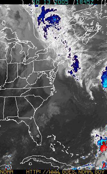
In New England the rain has claimed three lives in New Hampshire and has produced some of the worst flooding in decades from New Jersey north to Maine. The culprit is a deep plume of tropical moisture on a conveyor belt moving northwest across the open Atlantic and into our area. One look at the satellite map above shows the path.

Another 50-75mm could fall across all our areas through Saturday. Flood watches and warnings are in effect across southern New England and southeast New York.

Tuesday, October 11, 2005


Hurricane Vince hits Spain

The weather has cooled here in the east as a stationary front lying along the east coast draws moisture northward. Very heavy rain fell across the Maratimes this past weekend with the following totals measured:

ST JOHN ....... 142.0MM,FREDERICTON.... 93.7 MM, ST STEPHEN..... 135.5 MM, GRAND MANAN ... 225.4, MONCTON ....... 153.1 MM. Flooding was reported in both New Brunswick and Maine. Ten people died in flooding from the Carolinas to Maine.

Kemptville measured 64mm. Much colder air has arrived on northeast winds. The drizzle and fog is making it seem more miserable than our record heat. I have even had to turn the heat on in the house for the first time.

Over the weekend Hurricane Vince formed in the far eastern Atlantic. The storm moved inland over Spain. This was the first time in recorded history a named storm has hit this region.

Above: The picture above is a Halloween scene in the 27C degree record heat and haze of October 7th.

Wednesday, October 05, 2005

Hurricane Stan kills 66 in Mexico
Blizzard hits Dakotas/Manitoba -
Tammy forms in southeast US
As I drove around working today in shorts with the window rolled down, I realized we, here in the east, are living on borrowed time. Out west a fierce winter storm is hitting parts of Montana, the Dakotas, southeast Saskatchewan and Manitoba. Heavy snow in some cases over 30cm along with 50 to as high as 80km/h winds are occurring. Power lines and trees are snapping under the weight of the snow and high winds.

Meanwhile here in the east we are enjoying another day of record highs. It is 26C in Kemptville and Ottawa has tied another record for the third day.

Hurricane Stan came ashore near Vera Cruz Mexico with heavy rains and mudslides. More misery and death in this hurricane season.

Of interest to those of us in the east, Tropical Storm Tammy has developed east of the Florida coast. There is still plenty of uncertainty in her track but heavy rain and wind are expected as far north as the Carolinas. Interests from Florida to Nova Scotia should monitor the storm.

Above: The beautiful fall colors are starting to appear in Kemptville despite the 80 degree weather.

Tuesday, October 04, 2005

A SMOG ADVISORY* has been issued by the Ontario Ministry of the Environment for the following forecast regions:

For: Wednesday October 5, 2005 Algonquin Bancroft - Bon Echo Barrie - Orillia - Midland Brockville - Leeds and Grenville Burk's Falls - Bayfield Inlet - City of Ottawa - Cornwall - Morrisburg -Grey - Bruce Haliburton - North Bay - West Nipissing Parry Sound - Muskoka - Huntsville - Prescott and Russel -l Renfrew - Pembroke - Barry's Bay Smiths Falls - Lanark - Sharbot Lake Stirling - Tweed - South Frontenac

The SMOG ADVISORY for southwest Ontario and Toronto remains in effect.

Advisories will remain in effect until further notice. For more details visit the Air Quality Ontario website at: www.airqualityontario.com

During the smog episode, individuals may experience eye irritation. Heavy outdoor exercise may cause respiratory symptoms such as coughing or shortness of breath. People with heart or lung disease including asthma may experience a worsening of their condition.* A Smog Advisory means that there is a strong likelihood that there may be poor air quality within the next 24 hours due to ground-level ozone and/or fine particulate matter.

Spare the Air Actions
During a smog advisory, there are a number of actions that you can take to help spare the air. Travel tips - all year round: - leave your car at home - walk, cycle, carpool or take public transit - tele-conference instead of driving to meetings - limit car trips by doing all your errands at once, and do not let your engine idle - keep your car well tuned, check your tire pressure and drive at moderate speeds
Health tips: - avoid exposure to vehicle exhaust fumes - consult your doctor for specific health advice - wear light clothing at work while air conditioning is reduced - avoid strenuous exercise in the heat of the day
Electricity saving tips: - save electricity at home by setting your air conditioner temperature a few degrees higher (health permitting) and turning off lights you are not using
Other pollution reduction tips: - leave lawn mowing for another day - restrict the use of gasoline-powered equipment - delay using oil-based paints, solvents and cleaners.
Record warmth east - Snowstorm for Saskatchewan/Manitoba
While here in the east temperatures are soaring to near 30 with record highs being shattered including Ottawa's 26.3 yesterday, the west is preparing for a possible snowstorm. A Winter Strom Watch has been posted for portions of southern Manitoba and Saskatchewan. Winter Strom Warnings have been posted for North Dakota and Minnesota.

The heaviest snow will fall in a swath from central & southwest South Dakota across central North Dakota and into extreme southwest Saskatchewan and southern Manitoba. 10-20cm with 25-50km/h winds can be expected.

Meanwhile current temperature readings in the east are 27-30C across much of southern and eastern Ontario.

Friday, September 30, 2005

Above: Tree damage in Kemptville

Wind Damage across area....

Here is a quick summary of the peak winds yesterday. There was tree damage as well as signs and power poles knocked down. Some structual damage and crushed cars were reported as well.

TORONTO PEARSON 78 km/h
TORONTO ISLAND 74
PORT WELLER 82
POINT PETRE (Sandbanks) 111 (Peak Gust in Province)
KINGSTON 80
OTTAWA 67
KEMPTVILLE 60 (may have been stronger locally)
CORNWALL 92
WINCHESTER 74
MONTREAL 84

Thursday, September 29, 2005

High Winds Today
Environment Canada and The National Weather Service have posted high wind warnings for both sides of the border from Toronto to Montreal. In all areas today a sharp cold front will produce winds in excess of 50km/h with gusts as high as 100km/h. This is over Tropical Storm force to put things in perspective.

Already this morning winds are gusting to 42km/h here in Kemptville with some damage reported. Winds have topped 80km/h in Toronto and 98km/h in Port Stanley.

In addition short lived violent thunderstorms have been reported in a line from Alexandria to Cornwall moving east into Montreal. A second fast moving potent line had developed along the cold front and will move through Kemptville the Seaway and Montreal before noon today.

Be safe and forget about the umbrella.

For Marine interests, a Gale warning and waterspout advisory is in effect all day for Lakes Erie and Ontario. As well a Gale Warning is in effect for the St. Lawrence River.

I will have pictures later today.......

Wednesday, September 28, 2005

Strong cold front for Ontario/Quebec
A developing storm system over the Great Lakes will sweep a powerful cold front across our area tonight into Thursday morning. Showers and thunderstorms will accompany the front dropping more rain on already waterlogged Quebec City. Temperatures will drop behind the front on Thursday down to the single digits.

The big feature with this front will be Strong Winds from the southwest from 60-90km/h. These are capable of some wind damage, specially along the St. Lawrence and Richelieu Valleys and along the north shore of Lake Ontario. Warnings have been posted.

Heavy Rain is also forecast for the area north of Montreal and the upper Ottawa Valley.

A Wind Advisory is in effect for St. Lawrence, Jefferson and Lewis Counties in New York from 6am to 6pm on Thursday.

Sunday, September 25, 2005

Rita sweeps Northeast
Heavy Rain Warnings for Montreal/Ottawa

Despite earlier predictions of Rita stalling out over Mississippi for the better part of the upcoming week, she has decided to spare the south her heavy rains. Thankfully the storm is being swept northeast along a trough of low pressure. The system will slide down the St. Lawrence Valley into Monday with heavy rains forecast. Upwards of 100mm could fall in Ottawa and Montreal. Heavy Rain Warnings have been posted from Kingston to Quebec City and north to the Laurentians. Embedded thunderstorms are also expected and winds could be gusty.

While many people in Texas are beginning to return home it is a different story in Louisiana. The southwest part of the state; basically what was not hit by Katrina, was hammered by Rita. Heavy damage was reported in both Vermillion and Cameron Parishes. It will be days before the extent of the damage is known. No exact figure on casualties is available.

Meanwhile the death toll from Katrina has exceeded 1000.

Saturday, September 24, 2005

Rita Inland over Texas
Hurricane Rita's centre moved onshore near Sabine Pass on the Texas/Louisianna border around 3:30am this morning. The storm has pounded areas of southwest Louisianna including affecting the New Orleans area with another surge of water that has breached levees dumping 5 feet of water into portions of the city again.

It is early and damge assesments are underway, but it appears thea the Galveston/Houston area is going to be ok. I am very worried about the southwest coastal areas of hard-hit Louisianna. The state has certainly suffered another major event in Cameron Parrish and other parishes near the Texas border and along the coast. The storm is weakening further, but will remain a serious flood threat to Texas, Arkansas and Louisianna through mid week.

It is not expected to affect Ontario as a decaying depression.

Thursday, September 22, 2005


Rita continues towards Texas Gulf Coast
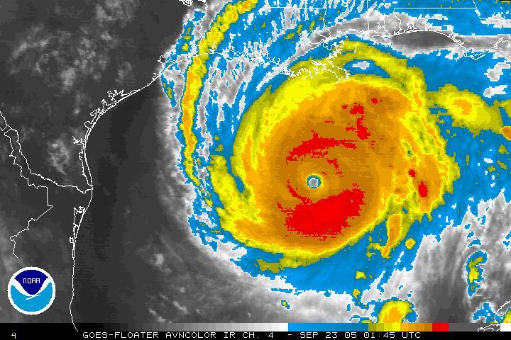
Hurricane Rita is continuing to move towards the Texas coast looking eerily like Katrina three weeks ago. While a slight decrease in intensity has occurred, that is pretty much academic at this point. She remains a very dangerous storm capable of severe damage and destruction.

The outer most rainbands are beginning to sweep across the coast this evening from Mississippi west towards New Orleans. Heavy rain and thunderstorms will increase in coverage over the next 24 hours leading up to landfall. Seas are rising already along the immediate coast. Areas already hit from Katrina can expect flooding from Rita.

Traffic is moving so slow inland north towards Dallas. My fear is always that people will become trapped on the highways as the storm hits.

Strong high pressure is blocking the storm from moving rapidly north. This will mean a prolonged period of heavy rain and wind far inland towards the northern portion of the state and Dallas.

Wednesday, September 21, 2005

Rita...Katrina's ugly twin......

Rita has become a 5.....

At 4pm EDT Rita has been upgraded to a Category 5 and is steaming through the Gulf of Mexico, 735 miles ESE of Corpus Christie, moving towards the west. A turn towards the north is expected with landfall near Galveston Texas expected. Mandatory evacuations are now in effect for coastal areas along the upper Texas Coast. There is still uncertainty and the storm could strike anywhere from southwest Louisiana towards Corpus Christie, TX.

http://www.hurricanecity.com/ is an awesome site with audio, pictures and numerous other resources. Please visit and support Jim and his site. I will post numerous updates as the week moves along. For now there is no reason to believe that this storm will be any less intense than Katrina. The conditions remain very favorable for Rita up until landfall.

Monday, September 19, 2005

Ophelia, Rita and Snow!!!
I was on vacation for a week and am suffering from a bout of some kind of flu bug, but the weather never stops does it!
It was a wild weather week for certain across many parts of North America. While I was visiting the snow capped Rockies in the midst of an early winter storm, Ophelia was taking pot shots at my other favorite destination, the Outer Banks of North Carolina.
Out west as much as 45cm of heavy wet snow fell in Crowsnest Pass, Alberta knocking down trees and power lines. In the valleys heavy rain, in some cases over 100mm fell. The rain has forced water levels on the Saskatchewan River to begin rising again.

Our attention is still on the Gulf Coast in the wake of Katrina. However we are now looking at newly formed Tropical Storm Rita. Rita is nearing Hurricane strength as she glides towards the southern Florida coast and the Keys tonight. The storm is expected to head into the Gulf and become a major hurricane. By the end of the week, she could be threatening the area from Louisiana west to Texas. This unreal season just continues to amaze me. At the same time Hurricane Philippe may affect Bermuda by weeks end.

Of Note: The western influence of Ophelia provided some lift to the rain over the weekend. Montreal had 35mm, Ottawa 25mm and parts of St. Lawrence County, NY hadover 100mm with flooding reported.
Below: Snow covered Rockies after last weekends storm

Tuesday, September 06, 2005

Hurricane Katrina devastates Gulf Coast

Eighty-percent of New Orleans is underwater today as the death toll soars along the Gulf Coast.

For some reason I have mulled over this most recent entry for many days and I am finally writing it. I have written it and rewritten it in my head several times. It is no great mystery to anyone who knew anything about hurricanes that New Orleans was vulnerable. 

I guess what is troubling me is the massive death toll we are expecting. Over the years many storms had produced large death tolls, but I thought the days of Camille (69), Betsy (65) and other storms were behind us. Forecasting science has become so much better, so has the ability to evacuate large areas of coastline. And yet we somehow failed with Katrina. FEMA and the US Government somehow forgot about those without cars or any other means to leave, as well as seniors and those under hospital care. Unfortunately it is these people who have been left behind, and in many cases will make up the large death toll. 

The images speak for themselves. It is beyond imagination the level of misery that we are seeing on the evening news. The word from those on the ground is it is even worse when you add the smell, sounds and inject 100 degree heat.

Flood ravaged downtown New Orleans, with Lake Poncthartrain in the background.

The task at hand is huge and being dealt with on a daily basis. The levees are being repaired the evacuees being dealt with finally and the bodies being collected. Canada is sending aid in the form of several ships, helicopters and Red Cross personnel. If you can help, please do so at http://www.redcross.ca/. Click on the Katrina link.

Of Note: In our area Katrina (tropical depression) moved through very quickly last Wednesday, August 31, with the worst weather along the Seaway. Cornwall had the peak wind gust at 79km/h. Rainfall was as follows, St Anicet, Quebec (on the St. Lawrence) 110mm, Montreal 75mm, Watertown, NY 100mm, Massena/Cornwall 80mm, Kemptville 40mm, Ottawa 35mm. Winds were gusty, over 50km/h along the St Lawrence River from Kingston to Quebec City.