Colorado storm heads
for Ontario & Quebec
A big fall storm is heading for our area. Today is sunny and mild im most of the province, but that will not last. Strong low pressure organizing in the Midwest will deepen into a major storm as it moves down the St. Lawrence Valley. A wide range pf precipitation is expected over the weekend. Travel will be slow if not dangerous around the Great Lakes and across the Ottawa Valley and Laurentians.
In the lower elevations it will be mainly a rain event with between 50-75mm expected with precipitation begining tonight and spreading northeast towards Montreal by Saturday morning. Warnings may be posted. In the regions to the west, north and upper elevations, a slushy mix of rain and snow and eventually all snow by late Saturday could result in over 15cm of wet snow by early Sunday. On the backside of the strengthening storm winds will gust from 50-80km/h on Sunday with snow squalls and blowing snow. Be advised this will hamper travel in Ontario, Quebec, New York and Vermont.
Warnings will likely be issued later today......
Friday, October 27, 2006

Friday, October 20, 2006
 Snow falls in Kemptville, Ontario today.
 SNOW!!!
A strong storm moving up the Eastern Seaboard dumped heavy rain across Ontario, New York and Quebec today. On the back side of the system this afternoon cold air is filtering into the St. Lawrence Valley and Adirondacks. Snow began to fall in Kemptville at 2pm and a slushy centimetre or two is on the ground.
The snow should accumulate up to 5cm in Kemptville and up to 15cm in the Adirondacks where a Snow Advisory is in place.
Friday, October 13, 2006
Buffalo hammered
Lake Effect snow spawned by an intense Great Lakes storm has virtually shut down the Niagara and Buffalo areas. A record that has stood for 88 years tumbled in Buffalo as more than 50cm of snow fell. The same is true in Fort Erie, Ontario where over 30cm is down. The heavy wet snow has brought down power lines and trees. Travel has been suspended in parts of Western NY with schools and business closed. The are affected is very narrow including 3 counties and the area along Lake Erie from Niagara to Long Point. In addtion some squalls have moved inland over Prince Edward, Leeds and Grenville Counties in Eastern Ontario.
Warnings remain in place for the hardest hit areas of Western New York and the Lake Erie Shore on the Ontario side.
In eastern Ontario and Kemptville, flurries are in the air, only days after we were in the 20's. We had 25mm of rain in the last 24 hours. It will be windy and cool today.
Tuesday, October 10, 2006
First Winter Storm of season
A strong Arctic cold front will blast the western Great Lakes this week with big changes in store for all of Ontario. The front will spawn a low pressure area over the upper part of Michigan that will become a potent fall storm. It is an early "November Witch". The storm will become intense with howling winds and heavy precipitation.
So far a Winter Storm Warning is in effect for parts of Northwest Ontario with Winter Storm Watches for the U.P. of Michigan and northern Minnesota and Wisconsin. Heavy lake effect snows are expected with close to 10 inches possible. Winds will howl over 40mph.
Windy wet weather will affect Eastern Ontario into Thursday with a cold rain and gale force winds. Over 25mm of rain will fall with dropping temperatures.
A strong Arctic cold front will blast the western Great Lakes this week with big changes in store for all of Ontario. The front will spawn a low pressure area over the upper part of Michigan that will become a potent fall storm. It is an early "November Witch". The storm will become intense with howling winds and heavy precipitation.
So far a Winter Storm Warning is in effect for parts of Northwest Ontario with Winter Storm Watches for the U.P. of Michigan and northern Minnesota and Wisconsin. Heavy lake effect snows are expected with close to 10 inches possible. Winds will howl over 40mph.
Windy wet weather will affect Eastern Ontario into Thursday with a cold rain and gale force winds. Over 25mm of rain will fall with dropping temperatures.
Friday, October 06, 2006

Tuesday, October 03, 2006

Thunderstorms in Ontario
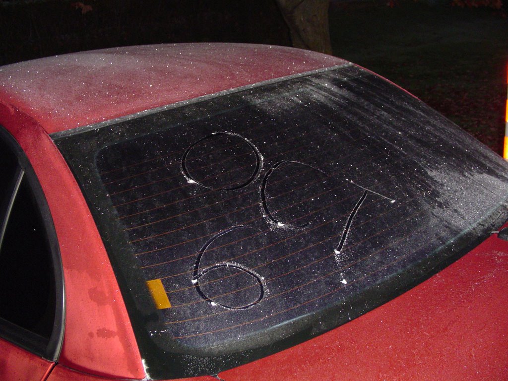
A unseasonably warm airmass moving across the US Midwest and Ontario has produced thunderstorms. A bunch of them crossed the 416 corridor today with heavy rain and frequent lightning. More heavy rain is expected tomorrow from low pressure as it slides down the St. Lawrence Valley. Winds will gust 30-60km/h and 20-30mm of rain is expected in Ottawa, Kemptville and the Seaway.
Fog has been a problem the last couple of nights. Above is a picture of it burning off in Kemptville this past weekend.
Thursday, September 28, 2006

Windy weather in the east
Hi everyone, sorry for the lack of entries lately. Struggling a little with writing time. Pic above is last Sunday in Montreal. Peak gust was 76km/h.
It has been a very windy week in Ontario and Quebec. A strong front last weekend produced 70-100km/h winds in both provinces. Tree and power lines were knocked down cutting power to over 250,000 customers. While most have been connected, Hydro One is still struggling with some in the Bracebridge and Barrie area.
To make matters worse another series of fronts yesterday and today is producing some severe weather adding to the outages. Over 30mm of rain is expected from the slow moving front as it crosses the 416 corridor today and tonight.
In the Atlantic, Tropical Storm Isaac has formed. He is not threat to land at this point, but interests in the Maratimes should monitor the storm.
Monday, September 18, 2006
Thoughts of Dawson College
Helene to remain out at Sea
Hurricane Helene is now a category three storm and is expected to follow much the same path as Gordon before her. This will keep the storm largely at sea with just large swells hitting Bermuda and the east coast. It appears that the storms are on a rail right now riding around a big ridge in the Atlantic and being blocked by weather systems along the east coast of North America.
• Snow fell this past weekend in Saskatchewan & Alberta. Heavy snow fell from Banff to Jasper while 5-10cm fell in southwest Saskatchewan including Swift Current. Ah so much for summer.... and fall for that matter!
• It reached 27C today in many parts of Eastern Ontario. This warm air will be short lived as a strong cold front brings heavy rain tonight and cooler temperatures on Tuesday.
• Warning: Non weather rant......
Just a quick note on the Dawson shooting last Tuesday in Montreal. I had written a big statement about how deeply troubled and sad I was regarding the terrible events, but I never posted it. It seemed to emotional and angry. I was both, but have settled down a bit since last week. It reminded me so much of the shooting of 14 women at the University of Montreal in 1989.
I was a student and News Director at the radio station in Dawson College from 1984 to 1987.
My thoughts and prayers are with Anastasia's family, and the other victims as they recover, as well as the students, staff and faculty as they begin to return to classes this week.
I was also very proud to be a Concordia graduate. Concordia University opened its doors within seconds and provided support to all who were affected by the tragedy. We need to stop these awful events from taking place. I don't have the answers, but we should not stop talking until we find them.
Helene to remain out at Sea
Hurricane Helene is now a category three storm and is expected to follow much the same path as Gordon before her. This will keep the storm largely at sea with just large swells hitting Bermuda and the east coast. It appears that the storms are on a rail right now riding around a big ridge in the Atlantic and being blocked by weather systems along the east coast of North America.
• Snow fell this past weekend in Saskatchewan & Alberta. Heavy snow fell from Banff to Jasper while 5-10cm fell in southwest Saskatchewan including Swift Current. Ah so much for summer.... and fall for that matter!
• It reached 27C today in many parts of Eastern Ontario. This warm air will be short lived as a strong cold front brings heavy rain tonight and cooler temperatures on Tuesday.
• Warning: Non weather rant......
Just a quick note on the Dawson shooting last Tuesday in Montreal. I had written a big statement about how deeply troubled and sad I was regarding the terrible events, but I never posted it. It seemed to emotional and angry. I was both, but have settled down a bit since last week. It reminded me so much of the shooting of 14 women at the University of Montreal in 1989.
I was a student and News Director at the radio station in Dawson College from 1984 to 1987.
My thoughts and prayers are with Anastasia's family, and the other victims as they recover, as well as the students, staff and faculty as they begin to return to classes this week.
I was also very proud to be a Concordia graduate. Concordia University opened its doors within seconds and provided support to all who were affected by the tragedy. We need to stop these awful events from taking place. I don't have the answers, but we should not stop talking until we find them.
Tuesday, September 12, 2006
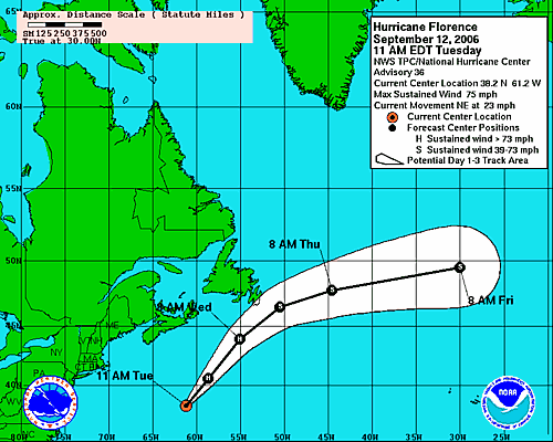
Florence is heading for Newfoundland
Environment Canada has issued a Tropical Storm Warning for southeastern Newfoundland. The centre of Florence is still about 600km from the coast but gales are extending well out ahead of the hurricane. The storm is undergoing a transition to extratropical state, which is a widening of the wind field and a loss of tropical characteristics.
The storm is expected to produce battering waves along the Newfoundland and Nova Scotia Coasts along with heavy rain, over 100mm and 100km/h winds in Newfoundland.
View the latest statement from the Canadian Hurricane Centre
Monday, September 11, 2006
 Please
 Remember
9-11
Frost Thunderstorms and a
Hurricane for good measure
Some of the worst thunderstorms of the season swept across the Ottawa Valley and Quebec on Friday afternoon. The intensity of them was a little bit of a surprise to me. They developed quickly in advance of a cold front. Winds were gusty, 50-100mm of rain fell, power poles were snapped and trees uprooted. Many parts of Carleton Place and portions of the City of Ottawa were left without power.
• Hurricane Florence with 80 mph is brushing Bermuda this morning. A wind gust of 79 mph was reported on the island. The storm will transfer into a very strong extratropical storm and move through Atlantic Canada waters by Wednesday. Gales and heavy rain are expected along the Avalon in Newfoundland, while Nova Scotia should have gusty winds and showers. Warnings may be needed for Newfoundland.
• Finally, frost occurred in parts of upstate New York and Eastern Ontario this morning. This is way too early for the time of year, but what can you do! The temperature was down to 5C here in Kemptville this morning, the coldest air since last spring.
Hurricane for good measure
Some of the worst thunderstorms of the season swept across the Ottawa Valley and Quebec on Friday afternoon. The intensity of them was a little bit of a surprise to me. They developed quickly in advance of a cold front. Winds were gusty, 50-100mm of rain fell, power poles were snapped and trees uprooted. Many parts of Carleton Place and portions of the City of Ottawa were left without power.
• Hurricane Florence with 80 mph is brushing Bermuda this morning. A wind gust of 79 mph was reported on the island. The storm will transfer into a very strong extratropical storm and move through Atlantic Canada waters by Wednesday. Gales and heavy rain are expected along the Avalon in Newfoundland, while Nova Scotia should have gusty winds and showers. Warnings may be needed for Newfoundland.
• Finally, frost occurred in parts of upstate New York and Eastern Ontario this morning. This is way too early for the time of year, but what can you do! The temperature was down to 5C here in Kemptville this morning, the coldest air since last spring.
Friday, September 08, 2006
Severe Thunderstorms
possible this afternoon
A strong cold front is racing across Ontario this afternoon. In advance of the front some severe weather has broken out. Warm southwest winds have driven temperatures up close to 27C. As the front presses southeast and east- storms over the Upper Ottawa Valley will begin moving south into Eastern Ontario. Some watches have been issued, they will be extended south and east over the next couple of hours. Stay alert to severe weather this afternoon.
possible this afternoon
A strong cold front is racing across Ontario this afternoon. In advance of the front some severe weather has broken out. Warm southwest winds have driven temperatures up close to 27C. As the front presses southeast and east- storms over the Upper Ottawa Valley will begin moving south into Eastern Ontario. Some watches have been issued, they will be extended south and east over the next couple of hours. Stay alert to severe weather this afternoon.

Wear RED and REMEMBER
WARNING: non weather rant....We are coming up on the anniversary of some big changes here at work; some good - some bad; and from what I understand more changes are on the way. Change is good, don't get me wrong. But we must be allowed the time to mourn the loss, appreciate the gain, if any, and adjust to the change. That just has not been the case at times lately here and in the real world.

• In that thought, today is Wear Red to Support The Troops Day, and every Friday from now on. It was started by the wives and families of Canadian & American Troops over in Afghanistan and Iraq. As the 5th anniversary of 9-11 approaches, take the time to remember, understand and appreciate all the hard work the men and women of the Canadian Forces are doing overseas to protect us from further attack by the cowardly terrorists.
• The images on the page today are the things that are in my thoughts for this Friday, September 8. It is a warm late summer day in Eastern Ontario with a southwest breeze, big shadows and beautiful maples turning red. I can appreciate all this because of the freedom we enjoy in North America. Remember who protects that freedom.
• On the tropical front, Florence is still expected to become a hurricane later today as it approaches Bermuda. It will make a big northward sweep and could brush Newfoundland late in the forecast period. I will update this possible scenario over the weekend. There is still much uncertainty in the forecast.

Tuesday, September 05, 2006
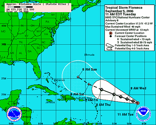
Florence develops in Atlantic
Tropical Storm Ernesto's floodwaters are still receding across the Eastern Seaboard. Up to 50mm of rain fell in Kemptville and Eastern Ontario over the weekend, while upwards of 250mm flooded parts of Virginia and the Carolinas.
In his wake Tropical Storm Florence has formed in the Atlantic, 1510 kilometres east of the Antilles. The storm is forecast to become a major hurricane by this weekend with some potential to impact the east coast. It will bear watching as we are too far out in the forecast period.
Friday, September 01, 2006
Ontario/New York and New England await Ernesto
The tropical remains of Ernesto will be moving north across Lake Ontario on Saturday night. In advance of the system - strong winds will begin to affect Vermont, New York and the St. Lawrence Valley. Winds will gust from 50-80km/h in many regions and may bring down some trees or power lines. Heavy rain will overspread Ontario from Windsor to Ottawa during the afternoon and evening Saturday. Storm totals could approach 75mm in places specially south and west of Kingston. Stay tuned for more information regarding the remains of Ernesto.
Gale Warnings are in effect for Lake Ontario and the St. Lawrence River. Flash Flood Watches have been posted for the western southern tier of New York and southern New England. They may be extended north.
The tropical remains of Ernesto will be moving north across Lake Ontario on Saturday night. In advance of the system - strong winds will begin to affect Vermont, New York and the St. Lawrence Valley. Winds will gust from 50-80km/h in many regions and may bring down some trees or power lines. Heavy rain will overspread Ontario from Windsor to Ottawa during the afternoon and evening Saturday. Storm totals could approach 75mm in places specially south and west of Kingston. Stay tuned for more information regarding the remains of Ernesto.
Gale Warnings are in effect for Lake Ontario and the St. Lawrence River. Flash Flood Watches have been posted for the western southern tier of New York and southern New England. They may be extended north.
Ernesto downgraded to depression
Ernesto is now a depression after slamming the Carolina Coast, moving onshore near Long Beach, NC overnight. The storm is now in eastern North Carolina dumping a tremendous amount of rain. In the last 24 hours close to 10 inches of rain has fallen in Wilmington and along the Outer Banks towards Duck. My favorite island, and for that matter many others as well; Hatteras Island, fared well in the storm. Heavy Rain did fall and winds gusted over 60mph but so far little damage is being reported. Flooding could become severe across inland areas and the coastal plain. Heavy rain is spreading north with flood watches as far north as New York State. Power is out to over 270,000 customers in North Carolina and Virginia.
The storm will move into Ontario by late Saturday with heavy rain and gusty northeast winds. Already clouds are streaming into the St. Lawrence Valley today on gusty south and east winds ahead of the low pressure area.
Ernesto is now a depression after slamming the Carolina Coast, moving onshore near Long Beach, NC overnight. The storm is now in eastern North Carolina dumping a tremendous amount of rain. In the last 24 hours close to 10 inches of rain has fallen in Wilmington and along the Outer Banks towards Duck. My favorite island, and for that matter many others as well; Hatteras Island, fared well in the storm. Heavy Rain did fall and winds gusted over 60mph but so far little damage is being reported. Flooding could become severe across inland areas and the coastal plain. Heavy rain is spreading north with flood watches as far north as New York State. Power is out to over 270,000 customers in North Carolina and Virginia.
The storm will move into Ontario by late Saturday with heavy rain and gusty northeast winds. Already clouds are streaming into the St. Lawrence Valley today on gusty south and east winds ahead of the low pressure area.
Thursday, August 31, 2006
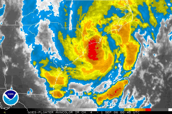 Tropical Storm Ernesto on
 the North Carolina Coast
It is almost a Hurricane and it is very close to Wilmington, North Carolina tonight. Ernesto is packing a punch. It is a vigorous tropical storm producing heavy rain and tornadoes as it moves onshore. At 8pm area observations included Kitty Hawk at 81F with heavy rain and an east wind at 17 gusting to 28 mph. Pea Island on the Outer Banks was E at 33G39 and Frying Pan Shoals southeast of Cape Hatteras was SE 39G49 knots which is close to 60mph. Waves were 15 feet. Already Wilmington has received 6.2 inches of rain. The storm will move across the state overnight and into Virginia tomorrow.
Flooding expected in Northeast
Ernesto will move towards Ontario
Tropical Storm Ernesto moved back over the Atlantic waters early this morning after crossing Florida. The storm produced heavy rain but little else in the sunshine state. Tropical Storm Warnings are in effect from Georgia north toward the Outer Banks of North Carolina. In addition flood watches have been posted for all of the southeast & mid-Atlantic states and may be extended into New York and Pennsylvania.
A Special Weather Statement has been issued for Ontario. The tropical remains of Ernesto will move into Ontario near Lake Erie on Saturday. Heavy Rain from 40-60mm along with gusty winds will occur throughout the weekend. Heavy Rain Warnings may be needed.
KATRINA: I watched a show on Hurricane Katrina last night on the Discovery Channel. It was very well done. Even one year later, and after tracking storms for over 25 years, I have a problem in dealing with the enormity of the disaster. One thing that has not changed in the year is the stupidity of politician's. I don't like to get political, I stick with the weather, but bureaucracy is an amazing thing. Take one of the strongest storms ever to strike the planet, stir in lots of water and sprinkle with stupidity, you get the idea. No one knows for certain how many of the deaths were needless, we may never know. People waited for days while politicians congratulated each other on the "flawless evacuation plan" and the "great progress of the recovery." One year later many neighborhoods are still waiting for a plan, still waiting for the storm to pass.
One thing is for certain, there were and continue to be many heroes who made and continue to make a difference. Ordinary people doing extraordinary things along the Gulf Coast.
Ernesto will move towards Ontario
Tropical Storm Ernesto moved back over the Atlantic waters early this morning after crossing Florida. The storm produced heavy rain but little else in the sunshine state. Tropical Storm Warnings are in effect from Georgia north toward the Outer Banks of North Carolina. In addition flood watches have been posted for all of the southeast & mid-Atlantic states and may be extended into New York and Pennsylvania.
A Special Weather Statement has been issued for Ontario. The tropical remains of Ernesto will move into Ontario near Lake Erie on Saturday. Heavy Rain from 40-60mm along with gusty winds will occur throughout the weekend. Heavy Rain Warnings may be needed.
KATRINA: I watched a show on Hurricane Katrina last night on the Discovery Channel. It was very well done. Even one year later, and after tracking storms for over 25 years, I have a problem in dealing with the enormity of the disaster. One thing that has not changed in the year is the stupidity of politician's. I don't like to get political, I stick with the weather, but bureaucracy is an amazing thing. Take one of the strongest storms ever to strike the planet, stir in lots of water and sprinkle with stupidity, you get the idea. No one knows for certain how many of the deaths were needless, we may never know. People waited for days while politicians congratulated each other on the "flawless evacuation plan" and the "great progress of the recovery." One year later many neighborhoods are still waiting for a plan, still waiting for the storm to pass.
One thing is for certain, there were and continue to be many heroes who made and continue to make a difference. Ordinary people doing extraordinary things along the Gulf Coast.
Tuesday, August 29, 2006
5pm Ernesto Update
Tropical Storm Ernesto has yet to intensify although the storm appears more organized on radar. The storm will move northeast across Florida into tomorrow before making a second landfall in the Carolinas.
Computer models bring the storm inland across the Appalachians and into southern Ontario this weekend. Our area will see heavy rain Saturday and Sunday. Stay tuned.... the threat for flooding across the Northeast and Ontario is very real.
The immediate future of the storm has it dumping heavy flooding rains across Florida. Up to 10 inches of rain may fall. The waves will be pounding the coast from Florida to The Outer Banks with some beach erosion.
Tropical Storm Ernesto has yet to intensify although the storm appears more organized on radar. The storm will move northeast across Florida into tomorrow before making a second landfall in the Carolinas.
Computer models bring the storm inland across the Appalachians and into southern Ontario this weekend. Our area will see heavy rain Saturday and Sunday. Stay tuned.... the threat for flooding across the Northeast and Ontario is very real.
The immediate future of the storm has it dumping heavy flooding rains across Florida. Up to 10 inches of rain may fall. The waves will be pounding the coast from Florida to The Outer Banks with some beach erosion.
Ernesto back over water
Tropical Storm Ernesto has emerged off the Cuban coast just south of Key West - Florida. The storm is expected to move northwesterly at about 12-14mph today and should begin to affect south Florida by mid-day. It will move across the central Keys and across the state towards Jacksonville before moving back over the Atlantic waters by tomorrow. At present a Tropical Storm Warning and Hurricane Watch are in effect from Bonita Beach and New Smyrna Beach south along both Florida Coasts. Ernesto may still become a Hurricane before landfall.
Once over the Atlantic after hitting Florida the center will make a second US Landfall near the North/South Carolina border, further west than initial runs. It is also expected to become a significant weather event for the eastern Great Lakes. Stay tuned to that for this upcoming weekend. Next update later this afternoon......
Tropical Storm Ernesto has emerged off the Cuban coast just south of Key West - Florida. The storm is expected to move northwesterly at about 12-14mph today and should begin to affect south Florida by mid-day. It will move across the central Keys and across the state towards Jacksonville before moving back over the Atlantic waters by tomorrow. At present a Tropical Storm Warning and Hurricane Watch are in effect from Bonita Beach and New Smyrna Beach south along both Florida Coasts. Ernesto may still become a Hurricane before landfall.
Once over the Atlantic after hitting Florida the center will make a second US Landfall near the North/South Carolina border, further west than initial runs. It is also expected to become a significant weather event for the eastern Great Lakes. Stay tuned to that for this upcoming weekend. Next update later this afternoon......
Monday, August 28, 2006
Ernesto over Cuba
Tropical Storm Ernesto the first storm to have reached hurricane status in the 2006 season has moved inland over Cuba tonight. The storm has been erratic and difficult to forecast. Early forecasts had the storm as a major hurricane affecting the Gulf Coast region. It now appears the storm may affect Florida as a tropical storm before moving up into the Carolina and Mid-Atlantic states. The storm reached hurricane status for a time late Saturday into Sunday morning. It will affect the US on the anniversary of Katrina. I am hoping and praying it stays away from Hatteras Island. I have vacationed there over the last 15 years and hope Avon and the surrounding villages are spared. It will be close call according to the computer models.
As of 8pm a Hurricane Watch and Tropical Storm Warning is in effect for the Florida east and southwest coasts. All interests in the southeast US should monitor the progress of the storm. The models are mixed with the storm affecting areas from Cuba to Maine a possibility. Updates can be found at hurricanecity.com.
I will keep a close eye on the system over the upcoming hours. Another update will be posted early tomorrow morning.
Tropical Storm Ernesto the first storm to have reached hurricane status in the 2006 season has moved inland over Cuba tonight. The storm has been erratic and difficult to forecast. Early forecasts had the storm as a major hurricane affecting the Gulf Coast region. It now appears the storm may affect Florida as a tropical storm before moving up into the Carolina and Mid-Atlantic states. The storm reached hurricane status for a time late Saturday into Sunday morning. It will affect the US on the anniversary of Katrina. I am hoping and praying it stays away from Hatteras Island. I have vacationed there over the last 15 years and hope Avon and the surrounding villages are spared. It will be close call according to the computer models.
As of 8pm a Hurricane Watch and Tropical Storm Warning is in effect for the Florida east and southwest coasts. All interests in the southeast US should monitor the progress of the storm. The models are mixed with the storm affecting areas from Cuba to Maine a possibility. Updates can be found at hurricanecity.com.
I will keep a close eye on the system over the upcoming hours. Another update will be posted early tomorrow morning.
Subscribe to:
Posts (Atom)