Monday, February 13, 2012

Quiet February rolls along

It looks like much more of the same in southern Quebec this week as high pressure will dominate the weather until mid-week. We start with a rather weak warm front lifting north of the St. Lawrence Valley this morning, accompanied by a few flurries, perhaps 1cm in elevated locations, if we are lucky. Temperatures were rather cold this weekend, but will rise to well above normal again this week as the arctic air shifts back to the north where it has been trapped most of the winter. Temperatures will be in the -2 to -4C range to start the week but warm to above freezing by Wednesday. Low pressure will head into the Ohio Valley by Thursday and take aim at southern Ontario and Quebec. At this time it looks like rain and maybe freezing rain to start perhaps ending in a period of snow. It is still early for that system, so we will wait and see as the week moves along.

Moncton on Sunday morning (CTV.ca).

The big storm this weekend was a rapidly deepening Atlantic storm that split the Maratimes in two with rain along and east of the track and heavy snow to the west. Snow fell fast and furious in Moncton and Charlottetown on Saturday night with between 25 and 40cm of snow. In Charlottetown, 32cm fell in just 6 hours. The storm also produced strong winds that cut power to wide areas of Nova Scotia, New Brunswick and PEI. In Newfoundland it was mostly a heavy rain event with some flooding reported as over 70mm of rain fell. Winds gusted to hurricane force with 107km/h observed at St John's, 124km/h at Burgeo and 148km/h at Wreckhouse. That gust at Wreckhouse damaged the anemometer, so that was the peak gust with the storm, but it might have been higher. Meanwhile in Labrador full blizzard conditions prevailed with heavy snow, gale force winds and windchill values as cold as -48C. It is frigid in Atlantic Canada this morning under clear skies and deep snow pack temperatures are in the minus 20's.

Saturday, February 11, 2012

Blustery cold weekend

Cold air poured into southern Quebec overnight in response to an arctic front slipping south of the region and into northern New York. The temperature rose to a mild plus 2C (36F) on Friday before slowly falling to around -1C at midnight. The front passed through the region and the temperature tumbled to -7C (19F) in one hour at Trudeau Airport, accompanied by some brief snow and gusty winds producing a windchill of -18C (0F). It has continued to get colder into this morning with current readings of -13C (9F) at the airport and -11C here on L'Ile Perrot. In southern Ontario, Toronto has declared a cold emergency where the temperature is currently -15C.

The sat image above the left from 11am shows a massive winter storm about to affect Atlantic Canada with heavy snow and rain. It will give strong winds and a few clouds to Montreal, but no snow.

Strong low pressure over Atlantic Canada combined with arctic high pressure over Ontario will produce a tightening pressure gradient over Ontario and Quebec. The result will be increasing northeast winds into Sunday here in Montreal. Temperatures will fall to -19C tonight, combined with strong winds increasing to 30 to 50km/h producing dangerous wind chill values of at least -30C (-20 to -25F). A windchill advisory may be needed for a portion of the area for Sunday. Conditions will be mainly dry for the most part with just the occasional flurrie here in Quebec. The heaviest snow with the Atlantic storm will fall over New Brunswick. Meanwhile Windsor, Ontario has about 12cm of snow overnight, and some lake effect snow will continue today of Lake Huron and Georgian Bay. Temperatures will moderate on Monday. No big storms on the horizon for Montreal at this time.

Friday, February 10, 2012

Weekend arctic air

We are looking at a mild Friday across eastern Ontario and the St. Lawrence Valley as well as much of southern Quebec with current temperatures just below freezing here in Montreal. Temperatures under bright sunshine and a gusty southwest wind will rise to about 3C. A strong arctic front will cross the region beginning late this afternoon in Ontario and this evening in Montreal. Along the front a brief period of snow along with gusty winds are possible with perhaps as much as 5cm locally. The biggest amount of snow will be near the Great Lakes. Once the front passes south of the region very cold northwest winds to 40km/h will drive temperatures down to the minus teens where they will remain until Monday. It won't be frigid, but cold, especially after the recent mild weather.

So where are all the storms? Well Europe is being hammered with snowstorms and fierce cold with snow being measured in feet and not inches. Also Alaska has had one traditional winter with frigid temperatures and hundreds of inches of snow for the season. For now the storm track remains well to our north with very little in the way of activity in the lower 48 and most of Canada. The exception will be portions of Atlantic Canada. This morning some snow is falling in Newfoundland as a coastal storm pulls out to seas. A second storm will develop near Cape Cod and move towards Nova Sctoia. Heavy snow is possible on Saturday across New Brunswick and PEI with as much as 30cm possible. In Nova Scotia it will be a snow rain mix with lesser amounts. Winds will gust over 70km/h at times producing blowing snow in New Brunswick.

Thursday, February 09, 2012

Cold weekend on the way

It will be a very mild and pleasant end to the work week today and Friday as high pressure noses into the region from the Ohio Valley. Southwest winds will push the temperature just above the freezing point in Montreal along with abundant sunshine. It will cool only to -5C tonight. Late on Friday a strong cold front will approach southern Ontario and Quebec likely sliding across the St. Lawrence Valley by the early evening hours. The front will be accompanied by gusty winds and some brief heavy snow flurries or squalls. A quick 2-5cm of snow will likely accompany the front followed by a flash freeze up making roads very icy by evening. Along with the snow and wind will be plunging temperatures as the cold air surges into the region. Temperatures will fall into the minus teens by Saturday with a gusty northwest wind. A second front will cross the area late Saturday with a reinforcing shot of Arctic air. Sunday will be sunny, windy and very cold with high temperatures staying in the minus teens and wind chills below -20C. It will warm next week with perhaps some snow by Tuesday.

Above: I thought I would post one more image from the great Northeast Blizzard of 1978. It is a street that many from Montreal and Quebec are familiar with, Ocean Blvd in Hampton Beach during the aftermath of the storm. This link has some great stories HERE.

Wednesday, February 08, 2012

Arctic air for weekend

It is much colder this morning than it has been during the last week or so. Still not much in the way of weather going on across Canada for February. I am showing -15C here on L'Ile Perrot with a light wind. Winds will pick up today, gusting to 40km/h at times creating a bit of a chill in the air, but the mercury will recover to -4C under bright sunny skies. High pressure should hold into Friday with seasonable temperatures for the region. On Friday and arctic boundary will sink southeast into southern Quebec, Ontario and New England with a push of very cold air. Some snow or flurries will occur along the front late Friday into Saturday along with falling temperatures to as cold as -20C by Saturday morning. The cold will be with us for the weekend before a moderation into next week. Once again, as I have said most of this winter, there are no major systems on the weather map at this time. The only exception could be an ocean storm that brushes Newfoundland by the weekend.

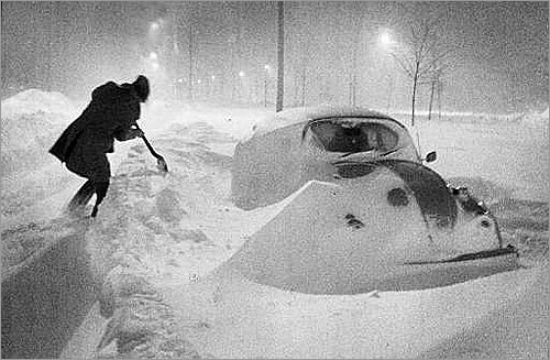
Above: Boston during the blizzard of 1978 (boston.com)

The Blizzard of 1978
I missed an anniversary yesterday that I had really not mentioned before on this blog. It was the 34th anniversary of the massive blizzard of 1978 that affected a large portion of the eastern US and Canada but especially Boston and coastal New England. The storm had its origins off the coast of the Carolina's as a sub-tropical low. It rapidly deepened while moving to a point off the New England coast and hanging around for a few days. The powerful storm produced hurricane force winds along the coast with widespread coastal flooding and damage in Massachusetts, Connecticut, Rhode Island and Long Island. Record snow fell, virtually closing down transportation and stranding thousands of motorists in their cars. Over 26 inches of snow fell in Boston with as much as 50 inches in other parts of New England. Power was out for days and schools shut for over one week. The storm claimed nearly 100 lives, many dieing in their cars from carbon monoxide poisoning. Montreal and southern Quebec remained on the western edge of the storm but still managed 10cm (4 inches) of snow along with a wind gust at Dorval to 76km/h. There are many great sites on the web with photos and stories from the storm including here at Boston.com.

Tuesday, February 07, 2012

Colder Tuesday

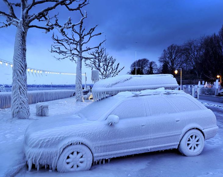
Ice coats cars along Lake Geneva as Europe shivers while Canada remains relatively warm. (National Post)

A strong cold front swept across the region overnight with very little in the way of precipitation, but a wind shift and much colder temperatures this morning. Several records were established yesterday across New England, Ontario and Quebec including 5.1C in Ottawa beating the old record of 3C from 1991. It was 4C in Montreal, 8C in Toronto and 9C in Burlington, Vermont. Most areas south and west of the city have very little snow left to speak of, here on L'Ile Perrot we have an icy 10cm (4 inches) or so still lying around. No major storms are in sight this week and into the weekend. The only weather to speak of will be another arctic front Friday night that could produce a period of flurries and perhaps a squall or two with its passage. Otherwise high pressure will dominate the week with temperatures mild for February. Highs have been reached today with temperatures falling by afternoon and evening down to -14C in Montreal. The balance of the week will see highs near -3C and lows around -16C. The weekend looks a little colder but again no major storms on the horizon.

The cold this February appears to be trapped across central and eastern Europe where some of the coldest and snowiest weather in over 25 years is affecting regions from Scandinavia east into Serbia and Romania. Governments have declared states of emergency with the death toll now exceeding 300 from the extreme cold and storms. Record lows have been established in many areas including as cold as -40C in the Czech Republic. The cold has frozen waterways across Europe including ice on the canals in Venice. Schools were closed in Rome as heavy snow fell.

Monday, February 06, 2012

Tropical devlopment?

There is not a lot going on in the weather department this morning. We are coming off a rather regular February weekend with chilly mornings and sunny, pleasant afternoons. Temperatures were as cold as -17C Sunday morning, but as warm as 0C by late in the day. We sit at 1C this morning along with a gusty southwest wind that has reached nearly 50km/h at times. The wind will continue for most of the day and tonight with a mild high of 3C expected in the St. Lawrence, Ottawa and Champlain Valley's. A cold front will approach from Ontario late this evening and overnight accompanied by some decent snow showers, much the same as Friday night when a quick 1-3cm fell across the city. Winds will be gusty and temperatures will cool behind the front to about -5C Tuesday and down to -17C by Wednesday morning. The rest of the week looks fair with perhaps another cold front by Friday. There are no major storms in sight at this time.

Meanwhile it remains mild everywhere for February with several record highs in Manitoba yesterday. Included were normally frigid Churchill Falls at -1.8C (-5.6, 1961), and Pilot Mound in the south at 8.8C (8.3C, 1963).

NOAA Image of the Gulf of Mexico and Florida with what appears to be a tropical system in the southeast corner of the image.

Another item that had the weather geeks buzzing yesterday was the formation of what appeared to be a tropical type system (depression/storm) in the Florida Straits. A rare February special statement was issued by the National Hurricane Center saying the likelihood of development was virtually zero percent with no circulation present. Nevertheless the system will move to the northeast bringing south Florida and the Keys a drenching rain and some gusty winds.

Friday, February 03, 2012

Weekend Update

Phil surprised everybody with his message yesterday!

I guess our little furry forecasters were at odds yesterday with Wiarton Willie here in Ontario predicting an early spring and Punxsatawney Phil in Pennsylvania saying it will be at least six more weeks of winter. Either way, as I said yesterday, good news for most of us. It has been a tame winter across the country with winter coming in pieces as opposed to an entire season. Most of the really cold air and ferocious storms have been occurring in Alaska where they have had just an extreme winter. Today it is the US Rockies turn for a day of winter weather. A snowstorm is producing heavy snow, from 1 to 2 feet and strong winds across Colorado and into the high plains of Nebraska. This included the metro Denver area where visibility was down to 1/8 of a mile in heavy snow and blowing snow this morning.

For us here in Quebec and eastern Ontario it will be a quiet weather weekend with just a few flurries possible late tonight but otherwise sunny and seasonable. High temperatures will be in the -5C range with lows overnight, chilly around -12C or so. The weather will be perfect for outdoor activities, assuming you can find some snow that does not have a half inch layer of ice on top of it. Or better yest skate, either here in Montreal at the Old Port or on the Rideau at Winterlude in Ottawa. Enjoy the weekend and be safe.

Thursday, February 02, 2012

Groundhog Day 2012

Nearly 18,000 people are waiting this morning for Phil's prediction in Pennsylvania. Photo www.visitpa.com/groundhog-day-live-stream

From Phil at 7:25am - shadow seen, six more weeks of winter.

We have made it to Groundhog Day 2012. I love the day, if nothing else it brings everyone into my weather circle for just a few moments. In reality the day goes back to the Festival of Candlemas which simply stated says, if it is sunny on February 2 six more weeks of winter, cloudy, an early spring. Either way as Canadians we win, 6 weeks would be an early spring. Now I know most of us in North America have had very little winter this year. However, as I walked my dog this morning around our ice encrusted neighborhood, I realized our winter has been pretty miserable. We have had bouts of very cold weather, punctuated with freezing rain every week and my yard has been snow covered since Christmas. So not a traditional winter, but winter just the same.

As we wait for predictions from Wiarton, Ontario and Punxsawtawney, Pennsylvania, I like the quote on Phil's accuracy via Inner Circle VP Mike Johnston, "He is not burdened with the necessity to be site specific". I guess we are, and yesterday was one of those days where location was everything. The best we could do in the temperature department in Montreal was -3C. This meant all our precipitation, about 6mm of it, fell as freezing rain. We had lots of ice and accidents to go along with it. In all we ended up with about 10cm of snow and 6mm of rain, but no mild air at all. One of the most difficult forecast situations here in the St. Lawrence Valley is predicting when a warm front will scour out the cold air at the surface. Some days it happens quickly, and others like yesterday, it does not happen at all. You had to head into Vermont and New York for that where Burlington reached 8C (47F). The cold air was just too dense to budge off the valley floor.

Wednesday, February 01, 2012

Icy morning


An icy start to the day on L'Ile Perrot (ValleyWX pic)

We are in the middle of a bad dream that never seems to want to end this winter. We have a major weather event underway this morning with freezing rain falling steadily in the city right during the morning commute. The ice has coated everything from cars to trees, and has slowed traffic to a crawl and closed schools.

To start, a freezing rain warning is in effect for southern Quebec and eastern Ontario. They have also been extended in the form of winter weather advisories for northeast New York and the US side of the St. Lawrence Valley. We managed around 9cm of snow yesterday in Montreal before it changed to freezing rain overnight, with about 2-5mm of ice forecast. The cold air remains well entrenched in the valley location with areas south of us already above freezing, nearly record setting. Here on L'Ile Perrot I am showing -5C, while in Burlington, Vermont it is plus 7C (46F) and 8C (48F) in Toronto. A warm front remains draped to the south of Montreal with very warm air to the south and cold air trapped to the north of the front. It may lift north of the region by late morning with precipitation tapering off. If we are lucky here in the city, the temperature may climb to plus 1C. The weather has resulted in the closure of numerous schools north of the city, delayed air travel at Trudeau and closed Highway 15 on the South Shore due to a major accident at this time.

Tuesday, January 31, 2012

Freezing Rain Warning...again

This will be my second attempt to write this entry as the first one was eaten by my dog, I mean a cyber gremlin. 

Environment Canada has posted a freezing rain warning once again for southern Quebec and eastern Ontario including the Ottawa Valley. Low pressure over northern Minnesota, will move across the Great Lakes and along the New York/Vermont/Quebec border on Wednesday. Stretching from the low into central New York State is a very slow moving, elongated warm front separating very warm air over southern New York and Ontario to the cold air here in the St. Lawrence Valley. The warm front will slowly lift towards the border and then stall out over the next 36 hours while the low pressure passes just south of Montreal. Snow mixed with freezing rain will affect both Montreal and Ottawa with a general 5-10cm of snow and perhaps 2 to 10mm of freezing rain starting this morning and lasting intermittently until late Wednesday. The greatest risk of freezing rain will be in the valley locations. Temperatures are chilly this morning in Montreal around –10C with a northeast wind, and will very slowly rise to around –2C by Wednesday. South of the front in places like Burlington, Plattsburgh and Toronto temperatures are already near 0C and will soar to around plus 7 or 8C by midday on Wednesday.

Monday, January 30, 2012

Another clipper on the way

From CTV.ca - snow and blowing snow Saturday night in the GTA.

There is so much ice in my neighbourhood this winter. On Friday we had about 7cm of snow followed by 13mm of rain, all that froze up overnight. I live on the shady side of the street so all the rain froze on my driveway as the temperature sat at the 1C mark most of the day. I was left with about 2 to 3 inches of ice, all the salt in the world is not helping, and so goes the winter of 2011-2012. As mentioned last week we have been plagued with system after system bringing warm air into Montreal. On the weekend we had another clipper system move from the Prairies across Ontario and just south of Montreal. The system was moisture starved with just a few flurries and showers for Montreal but around the Great Lakes numerous snow squalls made travel poor at times. Snow squalls developed across southwest Ontario including Toronto on Saturday and into western New York and the southwest St. Lawrence Valley on Sunday. One component of the low that did affect Montreal was the strong winds. Warnings were posted Saturday night for the city and winds gusted to 76km/h at Trudeau just after midnight, and 90km/h at St Hubert. Sunday was breezy but fair.

A new week begins with the same old forecast, another clipper. Today high pressure will dominate the region with sunny skies and seasonable highs around -6C. We are currently at -10C on L'Ile Perrot with a light west wind making it feel about -13C. Clouds will increase tonight as low pressure and associated warm front move towards Ontario and Quebec. Snow should start overnight in Ottawa and early tomorrow in Montreal and continue most of the day with about 5cm to perhaps as much as 10cm north of the city on Tuesday. The precipitation will mix with freezing rain and eventually rain late in the day as temperatures push to the freezing point and well above by Wednesday. Temperatures will be about -5C on Tuesday but as warm as plus 5C (41F) by Wednesday. The whole mess will freeze up again by Groundhog Day Thursday as temperatures tumble back below freezing. Get the salt ready!

Friday, January 27, 2012

Freezing Rain Warning

Top: Plowing the ice and snow off St. Charles in Kirkland this morning. ValleyWX
Radar from 7am this morning, a familiar scene this winter in Montreal with widespread freezing rain.

9am: the warning has now expired for Montreal as it is above freezing at 1C.

It what has become a typical event in Montreal, the snow has changed to freezing rain this morning. Not one storm this winter has been an all snow event for southern Quebec. Each system has either started as snow or ended as snow, but has thrown everything at us in between including thunder. This morning is no exception as deepening low pressure moves along the international border just south of Montreal towards Maine by this evening. A wide swath of precipitation is affecting the city with about 2 to as much as 5cm of snow overnight. The snow has since changed to a steady freezing rain with the mercury edging up to the freezing point. The freezing rain should change to rain shortly south of the St. Lawrence River but stay as frozen precipitation until at least noon north and west of Montreal and especially in the Ottawa Valley. Freezing rain warnings are posted region wide, with as much as 10mm of ice expected. They have forced cancellation of all school buses across eastern Ontario, essentially giving students a snow day. (My daughter will be happy!)

As the system moves to our east strong west to southwest winds will develop and gust to 70km/h. The rain will taper off to a few flurries by late in the day. Temperatures will edge up to plus 3C today before falling back to 0C tonight. Late on Saturday a clipper type system will affect southern and eastern Ontario into southern Quebec with another shot of light snow and gusty winds by late in the day. Temperatures will remain above normal for the weekend.

If your travels today take you south or west expect a mix of rain and freezing rain with conditions gradually improving this afternoon. However north and east of Montreal it will be a nasty day with snow and freezing rain and very strong winds causing blowing snow. Travel is not advised towards Quebec City and points north and east. Winter Storm Warnings are in effect for those regions with as much as 25cm forecast for Quebec City.

Thursday, January 26, 2012

Winter Storm Warning

This will be brief for the moment with a more detailed update later today. A potent low pressure area is forecast to move out of the Mississippi Valley and across New England on Friday. A large area of precipitation will begin after midnight and last into late Friday across all of southern Quebec. At this time it looks like a snow to freezing rain event with the potential for up to 10cm of snow and 10mm of ice for Montreal and points south, over 15cm of snow north. For this reason weather warnings have been hoisted across the region including southern Quebec and New England. Eastern Ontario has only issued a special weather statement at this time. Snow, sleet and freezing rain will be steady at times and driven around by 40-70km/h winds. Travel will become difficult overnight and early Friday. I will post more later today.

Wednesday, January 25, 2012

Back to winter...for a day

I guess I need to come to terms with the fact that it is just going to be this kind of a winter. I have never been a fan of the up and down temperature trends, which creates lots of icy, crunchy snow, which is useless to everyone. The sidewalks and residential streets have been in a constant state of slippery since Christmas. Sadly this trend will continue, after yesterday's warm high of 5C at the airport, 6C at my home, the temperature sits at -4C this morning with a very cold northwest wind up to 45km/h. It was a brisk walk this morning with the dog after the spring warmth of Tuesday, wind chill readings are in the minus teens. What melted yesterday has, you guessed it, frozen this morning. Our high for the day has been reached already with temperatures falling to -7C by late afternoon and -13C overnight. Skies will try to clear as weak high pressure nudges in from the west. Skies will remain fair on Thursday before clouds increase ahead of our next storm system on Friday.

Above: Texas has been beyond parched over the past year, but it is finally raining this morning. The problem is too much all at once with flooding reported. This storm will bring us snow by Friday.

Low pressure currently giving flooding rain to parched Texas will lift into the Ohio Valley on Thursday and across New England on Friday. Depending on which computer model you like, the storm will either give snow or rain. Environment Canada has been flip flopping on the forecast for the last 36 hours or so. It is a difficult call as well with so much warm air moving north with the storm. It looks like perhaps a similar event to most storms this winter, a mix of snow and freezing rain to start changing over to rain by Friday here in the south. We will have to wait and see with later model runs as to the type and quantity of precipitation expected here in southern Quebec, but Friday looks unsettled.

Environment Canada has posted a special weather statement regarding this potential storm. You can read it HERE.

Tuesday, January 24, 2012

Still mild in Montreal

Deep low pressure remains north of the St. Lawrence Valley this morning with mild air in place in Montreal. We are well above normal at 3C this morning and L'Ile Perrot was as warm as 6C overnight (43F). Needless to say lots of melting is occurring, at least in the city. There remains plenty of icy spots around in residential areas and many parking lots. Ice was a problem also this morning north of Montreal across the Laurentians where may schools are closed for the day. The weather will slowly improve today with dropping temperatures to around 0C by days end and perhaps a few flurries or snow showers. Winds will be gusty out of the west, but no real cold air is on the horizon. It will drop to -6C tonight and remain there on Wednesday, but that is normal for late January. The next threat for precipitation will occur overnight Thursday and early Friday.

Above: Storm damage in Alabama on Monday (The Birmingham News)

Yesterday's storm had a nasty cold front that brought a rare January round of severe weather to the southern US. Alabama was particularly hard hit once again with over 200 homes destroyed, 100 injuries and 2 fatalities. Every county in the state is under a disaster declaration for storm damage. The storm that hit Clay, Alabama in the wee hours of the morning was an EF-3 according to the National Weather Service, very strong at any time - let alone at night in January.

Monday, January 23, 2012

Light freezing rain possible

Environment Canada has hoisted freezing rain warnings once again as low pressure and a warm front approach Quebec from the southwest US. The warnings are for up to 5mm of freezing rain but are for areas north of Montreal. The southwest portion of the province along with Montreal is excluded from the advisory but we will have to watch that carefully as the day progresses. The storm is forecast to pass well to our north and west leaving the city in the mild air. The problem will be the light northeast winds, as always, at the surface of the St. Lawrence Valley. This morning for example Montreal is -7C while Burlington, Vermont is -2C. The onset of precipitation should be this afternoon, so hopefully the surface temperatures will have warmed by then.

Regardless of the temperature, most parking lots and sidewalks are icy already so any liquid precipitation on top will only make it more slick. Once the warmer air moves in on gusty southwest winds to 60km/h this evening, the temperature will surge overnight to a mild plus 5C (41F). It will cool only slightly on Tuesday with the passage of a cold front down to the 0C mark. This cold font has lots of energy with it and is producing severe weather and even tornadoes across portions of the lower Mississippi Valley. It is not out of the realm of possibility that we could have a rumble or two of thunder this evening in eastern Ontario and southern Quebec as the front races through. High pressure will build into the region for Wednesday with seasonable highs just below freezing before another storm system brings a chance for light snow by late Thursday.

As mentioned severe weather is moving across the south. Portions of Alabama, Mississippi and Georgia have had severe thunderstorms and tornadoes overnight with damage and injuries reported. A tornado watch remains posted for a portion of the area early this morning. You can view some video of the overnight storms HERE.

Friday, January 20, 2012

Weekend Update


Above & Below: Numerous wild temperature fluctuations this month has slowed snow clearing in the region and created icy roads and sidewalks. (ValleyWX Pic)

Temperatures are falling this morning after the passage of a cold front in the wee hours overnight. We started the night around -3C and are currently at -10C. I don't expect the temperature to warm any today, and it may even fall. Winds are gusty as well producing wind chill values close to -20C in Montreal. That cold front had some nasty snow squalls with it yesterday producing treacherous driving conditions in eastern Ontario. There were numerous accidents with visibility rapidly below 1km at times. The snow accumulated around 5cm in most areas with as much as 15cm south of the border in western New York. However the front went across L' Ile Perrot dry. There were just a few flurries overnight. Such is the case with convective activity, like summer thunderstorms once the source of heat and moisture were taken away (Lake Ontario/daylight) the front fizzled out.

The weekend looks to be much the same way the entire winter has been, variable skies, temperatures, winds and a little snow for good measure. We start today in Montreal with dropping temperatures most of the day down to around -18C or so by midnight. Then it will warm slightly overnight as clouds increase and perhaps a little light snow. Low pressure will move out of the Ohio Valley and into southern New England. I think it will be too far south to give us any appreciable snow. That will be followed by another weak disturbance late Saturday and yest another for Monday. In between look for partly cloudy skies. Temperatures will be cold to start but warm to well above normal again early next week. We could be looking at another snow to rain event Monday with more freezing rain possible.

Thursday, January 19, 2012

Quick burst of snow today

Strong winds, over 100km/h, swept Montreal yesterday cutting power ot over 30,000 homes in the metro region. (Radio-Canada)

It is another cold morning in Montreal with -21C here on L'Ile Perrot and -23C at St-Anne-de-Bellevue on the west island. The airport for some reason seems to be in a warmer bubble showing -15C. Arctic high pressure has at least brought us calm winds after yesterday's wind storm. Winds gusted as high as 107km/h in Montreal. Power was out to over 80,000 homes in the province but Hydro Quebec has since restored most of that by last evening with the exception of about 10,000 mostly in metro Montreal. People I spoke with yesterday told me how the wind was so strong it woke them up shaking their homes and moving frozen patio furniture off decks and into yards.

We have another quick moving windy system on the way over the next 12 hours or so, but it will be a very fast and rather weak storm. It will however bring a wind shift and perhaps a few snow showers to the area. Clouds will increase today with temperatures warming to -10C. Some snow shower activity and gusty winds to 50km/h will develop this evening. If you are travelling the 401 to Toronto late today and this evening there could be some brief bursts of heavy snow and blowing snow, especially from Brockville to Trenton.

Accumulations generally will be around 2 or 3cm, but as much as 8-15cm could fall along the northeast shore of Lake Ontario and as far northeast as Brockville along the St. Lawrence Valley. As a matter of fact a Winter Weather Advisory for snow and blowing snow is posted for Jefferson County, NY along Interstate 81, this includes Watertown, New York and the Thousand Islands region. Eastern Ontario and southern Quebec area will see a brief period of snow ending by midnight. Winds will shift back to the northwest overnight up to 40km/h and temperatures will tumble again into the minus teens and staying there on Friday. Windchill values once again will be close to -20C on Friday.

Wednesday, January 18, 2012

Wild weather ride

The numbers tell it all at Trudeau Airport, wild pressure fall and rise, strong winds and roller coaster temperatures.

What a night that was as strong low pressure passed very close to Montreal. The night started damp and chilly with freezing rain. That was followed by a wind shift to the west and an ever so brief wedge of warm air pushing into southern Quebec. The mercury went from minus 1C at 11pm to plus 4C at 1am (5C at my house) and then the tumble began. That brings us to a few hours later at 7am with a temperature of-10C ( -11C at my house) and wind chill reading in the minus 20's. Add to that fierce winds overnight that kept Montreal fire fighters very busy with downed tree limbs, exploding transformers and dislodged temp parking garages. Winds gusted to 100km/h at Trudeau Airport at 1am and 96km/h at 2am. I recorded a peak gust of 57km/h but I know that my anemometer is way too close to the house. As soon as the weather warms I will be moving it to a new location. The winds have cut power to close to 80,000 homes in Quebec, 12,000 on the Island of Montreal. Numerous schools north of the city are closed today.

Montreal had close to 12mm of precipitation yesterday which translated into about 10cm of snow and ice mixed together and a little rain to end the event. The wind warning has been allowed to expire for southern Quebec, but it will remain blustery and cold all day with a few flurries. Winds will continue in the 30 to 60km/h range most of the day.