Thursday, May 15, 2014

Warmest day of 2014 for Montreal on Thursday

A slow moving cold front is producing severe weather in Ontario and the US Midwest. This tornado formed near Cedarville, Ohio around 6pm Wednesday. (Photo Credit: Twitter @MarkBiddinger)
A warm front lifted its way north of Montreal on Wednesday leaving behind a warm and summery air mass. We managed a warm and humid 25C (77F) yesterday and the temperature is already 18C (65F) this morning. Look for a high of 28C (83F) in Montreal and perhaps even a few degrees warmer at some other southern Quebec locations. Winds will begin to increase from the southwest between 30-50km/h today ahead of a very slow moving cold front. That front has abundant moisture and plenty of thunderstorm activity along it that will arrive some time on Friday and remain with us through Saturday night. Heavy rain, perhaps over 25mm is possible late Friday. Temperatures will be warm today (28C) and tonight (20C) and cool to around 22C on Friday. The weekend at this time does not look great with showers expected and cooler temperatures.

This cold front has been affecting southwest Ontario and western New York as well as Ohio for the last three days. Heavy rain has produced flash flooding in western New York. On Wednesday numerous tornado producing thunderstorms were reported across central Ohio. Today more severe weather is likely in Ontario as well as NY, Pennsylvania and eastern Ohio. Environment Canada has confirmed the first tornado of the year in our country, an EF-1 storm capable of winds up to 177km/h touched down around 5:15pm on Tuesday evening near Mildmay, Ontario. Tree and structural damage was reported but thankfully no injuries.

SEVERE THUNDERSTORMS
I am working on a blog entry that explains the frequency and risk of tornadoes in Canada as well as the difference between a watch and warning. I will be posting this by the weekend. Severe thunderstorm season is here, always be weather ready in the summer. Already we have seen two fatalities in southern Quebec as a result of strong winds. Two men fishing on the Lake of Two Mountains were killed last weekend when their boat capsized throwing them into the frigid waters. It is important to know the risk when you head outside each day, whether it simply be the UV index or the risk for lightning and strong winds..

Tuesday, May 13, 2014

Clouds showers and thunderstorms for Montreal

There is no snow in baseball! Coors Field home of the Colorado Rockies in the snow on Monday. (Rockies Twitter post)
A very weak backdoor cold front has slipped south across the St. Lawrence Valley this morning introducing a cool northeast wind in Montreal. A backdoor cold front is simply a boundary of cooler air moving from northeast to southwest, opposite of their typical movement in southern Quebec.The air behind the front is of marine origin, damp and cooler Temperatures are down from the low 20's we had Monday afternoon, sitting at 9C (48F) this morning on L'Ile Perrot.

That front has very little moisture associated with it but has brought lots of cloud cover along with a maritime air mass. Clouds will prevail for the day and for most of the week, temperatures will be cool today at 17C (63F). The front will wash out later today over New York state setting up a wind shift to the southwest and bringing back warmer air for Wednesday and Thursday. Temperatures will be in the mid 20's both days with perhaps 27C if see a peek or two of sun. By Thursday a very slow moving cold front will produce showers and thunderstorms across southern Quebec and Ontario, lasting into the start of the long Victoria Day weekend. Thunderstorms will be more numerous today across southwest Ontario closer to the warmer and more humid air currently over the southern US. Some of the storms may be severe in nature with hail and high winds being the main threat especially from London to Windsor. Meanwhile snow is falling over northwest Ontario with 5cm in Kenora. The snow has finally come to an end in Denver and portions of Colorado and Wyoming. From 1-3 feet of snow fell across the region with less in the metro area of Denver. The good news is that highs will be close to 27C (80F) by the weekend.

Sunday, May 11, 2014

A little taste of summer

It was a windy, warm weekend across southern Quebec with it feeling almost summer like from late Friday evening into late Saturday. A little sunshine and some humid conditions on Friday helped fuel some evening thunderstorm activity from eastern Ontario into metro Montreal. A few of the storms were on the heavy side with frequent lightning and heavy rain. Around 11mm fell in Montreal, but Ottawa and some eastern Ontario locations had over 25mm (1 inch) in just a few hours. Temperatures were rather warm on Saturday in the middle 20's and just a touch cooler Sunday under bright sunshine. It was a breezy weekend, 30-50km/h and that will persist into this week. A complex weather pattern this week with high pressure early in the week, and then a series of fronts producing showers and thunderstorms from Wednesday on. The warm weather will continue with highs in the low to middle 20's and lows around 10C.

An incredible amount of snow has fallen across the Rockies today as far south as metro Denver. The photo above was taken in Albany, Wyoming where 1-2 feet of snow fell today. (The Weather Channel - credit to robk2). Interstate 80 is closed  from Rawlings to Cheyenne because of May snow!
STRONG WESTERN STORM
A strong low pressure area in the US southwest is producing heavy snow across portions of the Rockies including a few inches in Denver. Upwards of 1-2 feet of snow has fallen across northern Colorado into Wyoming. Meanwhile east of the falling snow, warm and humid air is producing severe thunderstorms with tornadoes across Nebraska, Kansas and Iowa. Major damage was reported in several small Nebraska communities including Exeter and Sutton. I spent part of the evening watching the live feed from Greg Johnson at TornadoHunter.com and the storms were rather impressive. The good news is that despite all the damage in Nebraska today, thanks to advance warning of up to 15 minutes from meteorologists, no fatalities were reported.

Wednesday, May 07, 2014

Warmer weather slow to arrive

High pressure will settle across southern Quebec for the middle portion of the week with some much needed sunshine and relatively warmer temperatures near 17C (63F). The overnight hours will be chilly with lows near 2 or 3C. Environment Canada has an advisory out for the risk of scattered frost. There was a little this morning in off island communities north and south of metro Montreal. I recorded a low of 1.1C (34F) at 5:45 this morning on L'Ile Perrot with just a hint of frost on the car. The same will hold true for Thursday morning, with nothing but sunshine forecast today and a few increasing clouds later on Thursday. Warmer temperatures along with a few showers and thunderstorms are forecast for Friday and Saturday before we get a sunny and warm (21C/70F) Mothers Day. As a matter of fact most of next week looks warmer than normal as some of that sultry air that has been gathering over Texas begins to move northeast.

The view from the top of beautiful Mount Washington this past week. Winter remains in control on the top of the 6200 foot peak. Mount Washington is getting ready to start the new visitor season. It is well worth the trip. Look for more info HERE. (Mount Washington Observatory Photo) 
WINTER WILL NOT GO!
Winter is trying to hold on with snow over the weekend in Alberta and a big heavy wet snowstorm in Newfoundland Monday. Nearly 30cm of snow fell in Gander with 10cm in St John's. Closer to home Mount Washington, New Hampshire is only 25F this morning. They have had lots of snow, over 30cm (1 foot) in the past week and remain in winter mode for the time being in hopes of starting the tourist season by Memorial Day weekend. The 12.6 inches of snow to start the month of May is the most at the summit dating back to 2006. The mountain toll road remains closed to regular traffic as snow clearing operations continue.

Monday, May 05, 2014

Warmer weather this week for southern Quebec

Nearly 25cm of wet snow fell across southern Alberta this past weekend in what has been a stupid spring to say the least across most of the country. (CTV News)
The weather typically settles down in May after the turbulent and changeable month of April. This May, not so much so far with lots of rain and even snow this past weekend. Montreal had plenty of rain as a very slow moving upper level low moved from the Ottawa Valley to the Gulf of Maine. Another 25mm or so fell over the city this past weekend as our wet, cool spring moves along. We remain below normal in the temperature department with the flowers and trees seeming to be two to three weeks behind schedule. It looks a little better today in southern Quebec with showers tapering off by noon and perhaps a peek or two of sunshine this afternoon. Temperatures will try to go north of 12 or 13C. Cool tonight down into the middle single digits with followed by a mix of clouds and sun for Tuesday and highs near 13C again. It looks like sunshine and mild temperatures of 17C for Wednesday, it what will likely be the best day of the week and of the month so far. At this time the Mother's Day weekend looks like a split with showers on Saturday but sunshine and warm highs near 21C (70F) for Sunday.

The Trans-Canada Highway in southern Alberta on Saturday.
Over the weekend we had an incredible mix of weather reported across western Canada south into the southern US plains. Calgary and the Rockies had over 20cm of wet snow, this after highs in the low 20's Friday. The snow caused a host of problems from power outages and downed trees to numerous accidents across southern Alberta. The same system also produced snow across the Dakotas and thunderstorms across the central plains. While the snow was forecast in Alberta, strong winds and dry weather helped fuel a major brush fire in southern Saskatchewan outside Swift Current that threatened northern parts of that community late last Thursday. Meanwhile south Texas had record breaking triple digit heat over the weekend with highs in the 90's to over 100F in several locations across the western portion of the state. More heat and very strong, dry southwest winds are forecast today with an elevated fire danger over northern portions of Texas into Oklahoma. A major brush fire in Oklahoma on Sunday destroyed several homes and led to 1 fatality.

Thursday, May 01, 2014

New month...same weather

The damage continues to mount up and down the Eastern Seaboard from heavy rain, flooding and tornadoes. This street in Baltimore collapsed onto railroad tracks as a result of heavy rain. (Washington Post)
If April showers bring May flowers, where are they? More importantly what do May showers bring? I have measured close to 50mm of rain (2 inches) here on L'Ile Perrot since late Sunday night. A little less at Trudeau Airport with close to 40mm. The rain for the most part has remained within the river banks in southern Quebec, with minimal flooding being reported along the shores of Lake Champlain and the Richelieu River as well as Lake of Two Mountains according to Urgence Quebec. Showers will continue this morning in Montreal. It is good to see April over, not a record cold month by any stretch with only around 1cm of snow for Montreal, but damp and dismal just the same. The average temperature at Dorval was 10.6C around 1 degree below normal. We only managed 1 warm day, actually just a few hours on April 14 when it reached 25C. Rainfall was abundant for the month at 135.8mm. The wet, cool start to spring has left little growing in my neighborhood with no leaves to speak of on any of the trees and very few plants flowering.

The weather will be damp again today with perhaps a few peeks of sunshine this afternoon. If we see the sun it will warm up to 16C. Enjoy it as cool and showery weather returns tonight and lasting well into Monday with temperatures around 12C for highs and 7C for lows. The culprit continues to be a slow moving upper level low over the Great Lakes. This system pumped copious amounts of tropical moisture up the entire east coast on Wednesday with major flooding rains from the Gulf Coast to New England and heavy rain pushing into Ontario and Quebec. The southern half of the system will move offshore today with improving weather for the deep south and middle Atlantic, while the actual low remains slow to traverse our area. I don't expect warmer or dry weather before next Tuesday.

Wednesday, April 30, 2014

Heavy rain & flooding

Heavy rain is producing major flooding along the Gulf Coasts of Florida and Alabama. Downtown Mobile above from Twitter - Casey Toner - AI.com
The pesky low pressure area that has been causing so much deadly weather across the US is still slowly moving east from the Great Lakes. The system produced another day of strong tornadoes across the southern US stretching on Tuesday north towards the southern Great Lakes. Thunderstorms even fired up in southern Ontario yesterday afternoon with heavy rain and small hail. The death toll since the weekend is well over 30 now in the US. Yesterday a new twist was added to the storm with heavy, flooding rains across Florida and Alabama. Coastal areas of both states received an unbelievable 500mm of rain in less than 24 hours (over 20 inches). To put that into perspective, Montreal is under a heavy rain warning for the next 24 hours with 25-50mm possible, that is only 1-2 inches, and watch how hard it rains tonight. That will give you a good idea of the deluge that must have fallen in Mobile, Alabama and Pensacola, Florida Tuesday and last night. Needless to say widespread flooding has occurred with numerous water rescues and 1 fatality. Roads including Interstate 10 in Florida remain closed as flood waters slowly recede today.

HEAVY RAIN WARNING
More rain is in the forecast for the southern US and is stretching north towards southern Quebec. A deep plume of tropical moisture will overrun the east coast and St. Lawrence Valley tonight with rain and perhaps some thunder into Thursday morning before tapering off. A heavy rain warning is in effect for southern Quebec this afternoon and tonight. Normally warnings are issued for 50mm in less than 24 hours, but I believe in this case the concern for flooding in southern Quebec remains elevated, thus the warnings.
Temperatures will be cool today in Montreal at 8C with northeast winds. Tonight cool and damp with lows of 5C. On Thursday, if we are lucky, a few sunny breaks and a warmer south wind may drive the temperature up into the high teens (19C) in Montreal.

Tuesday, April 29, 2014

Another day of violent storms across the southern US

The damage was complete from a Sunday tornado in Mayflower, Arkansas. The three day onslaught of severe weather has left 29 dead. (CNN)
A slow moving low pressure area with a nasty trailing cold front along with all the right ingredients of wind, temperature and moisture continues to produce a multi-day severe weather outbreak across the southern US. On Monday it was Mississippi and Alabama that bore the brunt of severe thunderstorms and massive tornadoes. Nearly 3 dozen tornadoes were reported across the region and into northern Georgia and western Tennessee. Hardest hit yesterday were the communities of Louisville and Tupelo, MS where a mid afternoon tornado destroyed dozens of homes and businesses. A dozen fatalities were reported on Monday across the south bringing the death toll up to 29 since Friday night.

A Twitter photo showing the power of a tornado to throw debris into the air. This storm was in Baxter Springs Kansas on Sunday afternoon.
I have a modest understanding of the mechanics and power of these deadly storms and even I have been astonished by the level of destruction. Entire downtown cores have been leveled and cars tossed into piles in fields. The storm that is causing all this severe weather is a slow moving low pressure area centered over the Great Lakes. The system has a trailing cold front slicing through unstable air across the southern US. Combine that with low level moisture blowing in from the Gulf of Mexico and you have all the ingredients necessary for a big outbreak. It will continue today with more tornadoes forecast from Mississippi east to the Atlantic Coast and severe thunderstorms as far north as the Great Lake states.

This system will control the weather in Montreal for the entire week with cool northeast winds and lots of moisture beginning tonight. Montreal and the entire region could see up to 40mm of rain by Friday. It will be cool with highs up to 13C and lows around 7C. Any thunderstorm activity at this time locally will be confined to southwest Ontario particularly London to Windsor.

Monday, April 28, 2014

Strong tornadoes hit US from Arkansas to North Carolina

A photo posted on Twitter by The Weather Channel's Jim Cantore of the 1/2 mile wide Vilonia, Arkansas tornado on the ground after dark last night, a very dangerous situation.
What had been a very slow start to the 2014 tornado season changed rapidly this past weekend. A series of long lasting and wide tornadoes swept across several communities from the southern Plains into the southeast US over the weekend. Until Friday night, the US had yet to report an EF3 tornado or stronger on the Enhanced Fujita scale (0-5), the latest of any reporting year since 1952. Late Friday strong thunderstorms produced an EF3 tornado in Washington County, North Carolina, killing an 11 month old boy, the first fatality of 2014. It was just the beginning of a long, violent weather weekend that will continue into today. Last evening a half mile wide tornado flattened the Little Rock northern suburb of Vilonia, Arkansas. The community of just over 3000 was nearly wiped off the map. The storms last night have killed at least 18 people with the death toll likely to climb as first responders sift through destroyed homes and businesses at first light this morning.

Another Twitter photo taken by a drone flying over Interstate 40 and showing tremendous damage to cars and trailers just outside Mayflower, Arkansas.
Greg Johnson of TornadoHunter.ca, a well respected storm chaser from Saskatchewan, has been on the ground all night in Vilonia helping to rescue survivors and administer first aid. He reports it is a difficult situation with many killed and injured and incredible, potentially EF5 damage. The storms continue this morning and will become intense later in the day across many of the same regions and expanding east. Tornadoes were also reported in Oklahoma, Kansas and Missouri.

Montreal Weather
The same slow moving low pressure area that is helping to fuel those storms in the southern US will affect the weather in southern Quebec this week. It will be sunny in Montreal today, but with that same northeast wind and chill in the air. Look for highs near 12C (54F), still below normal. This will be the best day of the week. Low pressure over the western Great Lakes this morning will move eastward and stall over the eastern lakes by Wednesday. It will send clouds on Tuesday followed by rain for the balance of the week. Temperatures under clouds and persistent precipitation will remain chilly, 11 to 14C for highs and 5 to 7C for lows. A few isolated non-severe thunderstorms may make it into southern Ontario, but any severe weather will remain well to our south this week.

Thursday, April 24, 2014

Slow warming this Spring

AccuWeather long range forecast map showing a continuation of cold weather for southern Quebec into the start of May and perhaps beyond.
As expected, we are off to a very slow start this Spring across southern Quebec and most of North America. The ice is gone from most rivers and lakes but the water is still very cold and greatly influencing temperature patterns in eastern Canada. I worked outside yesterday and noticed very little is growing or turning green this year. Lots of cold rain, wind and even some snow on the weather map this morning. Montreal managed 11C (52F) on Wednesday, which is below the normal high of 14C (56F). Combine that with cloud cover in the afternoon, and northwest winds up to 50km/h, and it was not too pleasant outdoors.

We start the day with sunshine but breezy and cold at 1C (33F) here on L'Ile Perrot. It will be a dry day with gusty winds and a high of 11C. Clear skies tonight will allow for cold temperatures once again with lows near 0C (32F) in the city but below off island. More sunshine for Friday but through increasing clouds and perhaps a degree or two warmer at 13C. The weekend at this time looks dreary with clouds, cool temperatures and showers both days as low pressure crosses the region. We may see some clearing late Sunday. Temperatures will be near 10C (50F) for daytime highs with lows around 2C (36F).

SNOW!
We have some snow around this morning along the lower north shore of Quebec. Snowfall warnings are in effect with 15-25cm possible around Sept Isles. The snow is being caused by low pressure passing off the Atlantic Coast near Nova Scotia. The same system is bringing a cold rain to other portions of the Maritimes.

Monday, April 21, 2014

Seasonal week ahead for Montreal

Richelieu River flooding near Sabrevois, Quebec over the weekend. (CBC News)
After 144 days of snow cover here on L'Ile Perrot, the last piece of icy snow melted away from my front lawn this past Saturday. Officially at Trudeau Airport, the end came April 4. I never thought winter would finish this year, but it did and rapidly in the end. Even most of the ice is gone from the rivers and lakes around southern Quebec. I was in Sherbrooke on the weekend and it is amazing just how high and how fast the water on the St Francois River came up last Wednesday. It has since receded but left behind are tons of broken trees lining the river, piles of mud and lots of water logged personal effects sitting in the driveways of residents right along the rivers edge. The clean up will take some time. Currently most rivers are on the way down, even Lake Champlain has stabilized at 100.4 feet, but flooding is still being observed along the New York/Quebec border as well as high water levels in the Richelieu Valley. A flood watch remains in effect for those locations. The forecast does have more rain in it after a rather chilly but pleasant Easter weekend. Expect partial sunshine today with a high near 17C (63F). Clouds thicken early this evening followed by a period of rain overnight and mild lows near 8C (47F). Tuesday will be showery and breezy with the passage of a cold front and a high near 17C. Skies will slowly clear for Wednesday, but it will be colder with high temperatures near 9C (48F).

Saturday, April 19, 2014

Tranquil weather allows flood waters to recede

The flood waters shown above in Sherbrooke on Wednesday have now receded with roads reopened and residents returning to begin the clean up. (CBC News)
Much quieter weather is on tap for this Easter weekend across southern Quebec as well as southeast Ontario and New England. A cold front is moving across the St. Lawrence Valley early this morning with clouds and an isolated shower or snowflake occurring. Skies will clear out early with sunshine dominating the weather today and Sunday. Temperatures will be cool today, near 8C, and downright cold tonight with lows in the -5 to -10C range. Sunday will be much warmer with highs up to 16C. The good news is the cooler weather has allowed the flood waters in many southern Quebec communities to recede and for residents to begin the clean up. Hard hit cities like Sherbrooke and Lennoxville had the water drop several feet in just a few hours on Thursday.

One waterway that is still on the rise is Lake Champlain, which flows north into the Richilieu River. It typically floods later in response to all the flood-waters entering it from the smaller tributaries as well as melting snow in the Adirondacks and Green Mountains. Early this morning, Lake Champlain at Rouses Point on the Quebec border is at 100.4 feet. Flooding starts at 100 feet. A flood warning is in effect for Lake Champlain, and this water flows north into southern Quebec. A flood watch remains in effect from Urgence Quebec for the Richilieu River as well as several other southern Quebec rivers. The Chaudiere River near Megantic is still on the rise with moderate flooding reported. Otherwise all other rivers are stabilizing with only minor flooding reported including Lake of Two Mountains here in metro Montreal.
The good news is no major rain is forecast through Monday with the next precipitation forecast for Tuesday.

Wednesday, April 16, 2014

Widespread flooding across Quebec - Ontario & New England

Flooding in Sherbrooke. (Sherbrooke Record)
NEW RECORD LOW THIS MORNING FOR MONTREAL
The heavy rain and snow are well off to our east this morning as cold air and high pressure settle into southern Quebec. Between 25-50mm of rain has fallen in the region since late Sunday, the bulk of that coming along a cold front Tuesday afternoon. That front dropped temperatures in a hurry with rain changing to wet snow in Montreal by 5pm on Tuesday. Depending where you were in the metro region you had between 1-5cm of snow. This coming on the heels of a 16C high. Even better is where the temperature is this morning, at -7C, a new record low for Montreal for the date. It has eclipsed a long standing record low of -5C set in 1943. Sunshine will dominate today but it will only make it up to 2C. Warmer weather will return starting tomorrow. The front yesterday was impressive with the temperature at my home on L'Ile Perrot hitting 16.1C at 10:57am. As the front progressed across the city temperatures fell rapidly to 11C in a few minutes, down to 7C within the hour and below freezing by 4pm.

My daughter Maggie LB took the photos above and below of the swollen St Francis & Massawippi Rivers spilling onto the Campus at Bishops University in Lennoxville on Tuesday. The Campus remains closed today.
MAJOR FLOODING
The rain and melting snow have caused widespread flooding across the southern half of the province. Numerous rivers including the St Francis, Yamaska, Chateauguay and Chaudiere and even Lake Champlain are over their banks this morning. Homes, business and many roads are flooded. At last count nearly three dozen roads were inundated or closed in Quebec, mostly across the Townships and Beauce. About 600 people were forced to evacuate in Sherbrooke after the Saint Francis & Massawippi Rivers overflowed into certain sectors of the city. Further downstream conditions were the same in Lennoxville where water poured onto the Campus of Bishops University. Classes and exams were cancelled for the day yesterday and the Campus remains closed today to non residents with students asked to remain in place for now. According to the Mayor of Sherbrooke, the worst is yet to come with more snow melting in the mountains and the water continuing to rise. More of the same in northern Vermont and New York where rising waters have closed many roads, forced evacuations and led to water rescues. In Eastern Ontario the Kemptville Creek and Rideau River are spilling over as well flooding farmland, roads along the waters edge as well as the Rideau Glen golf course. Around Laval and the island of Montreal the St Lawrence, Mille Iles and des Prairies are also on the rise and under a flood watch from Urgence Quebec.

The Massawippi River. Photos Maggie Lowson-Balena
Colder temperatures today will slow down the melting and runoff, but it is only temporary as the water has to run its course. The good news is no major rainfall is forecast for the short term.

Tuesday, April 15, 2014

Near record warmth to snow in 24 hours

Montreal missed a celestial show overnight due to cloud cover as a full lunar eclipse took place. It began at 2am and lasted three hours. This photo was provided from NASA.
Heavy Rainfall Warning 15-25mm for Montreal today.
Flood Watch - all regions of southern Quebec
Rapid temperature drop today from 13C (55F) now down to -8C (17F) overnight in Montreal.

What a wild weather ride we are on here in southern Quebec and Ontario. Toronto reached a high of 21.2C on Monday, over 70F. They are currently -1C with snow. Windsor has had about 7cm of snow overnight after being in the highs 20's. Meanwhile yesterday the warm front created a very sharp range of temperatures across the region. At one point as little as 40km separated temperatures near the freezing point from highs in the middle 20's. When the warm air finally arrived in Cornwall Ontario around 11am Monday, the temperature went from 14C to 25C in one hour. St Anicet near Valleyfield surpassed a long standing record with a high of 28.3 (83F) beating the old record of 26.7C from 1968. In Montreal we managed a high of 24.5 after a low of 2.2C, just amazing.

Not lost in all the temperature talk was about 20mm of rain in Montreal from late Sunday into Monday evening. The rain combined with rapid snow and ice melting continues to produce flooding across the entire region. A flood watch remains in effect for southern Quebec and northern Vermont and New York. More rain is in the forecast today along with increasing winds and dropping temperatures. Expect an area of precipitation to spread across eastern Ontario and into southern Quebec this morning. Rain will gradually mix with and change to snow by late today before ending near midnight. I expect a good 15-25mm of rain in most areas with perhaps 1-3cm of snow depending on what time your community changes over. This will vary from eastern Ontario which will occur early today to the US border by late this evening. Temperatures have reached the high for today and will drop to the freezing point by 7pm in Montreal and down to lows of -8C tonight. Wednesday will see sunshine and cool temperatures with highs around 2C.

Monday, April 14, 2014

Classic winter vs spring battle

Flooding has started in Laval from the Mille Iles River. (CTV Montreal)
You have to love Canada in April with every weather possible in the next 48 hours across portions of Ontario and Quebec. We have a stubborn cold air mass stuck in the St. Lawrence Valley right now. As is typical with a warm front to our south, northeast winds are keeping the temperature in check in Montreal as we sit at 3C (38F) while just to our south, Potsdam New York is 18C (65F) and Malone is 16C (61F). That warm air should surge into Montreal by midday as the low clouds and fog begin to burn off and we reach a high of 21 to 24C (70-75F).

We were treated to our first thunderstorm of the season last night here on L'Ile Perrot. Thunder with heavy rain, about 9mm, fell around 9pm last evening. The rain was not as bad Sunday in metro Montreal as expected but that did not stop areas rivers from rising. Flooding from rapid snow melt continues across the region and especially south of Montreal. Flooding has also reached the metro region with Laval reporting water on the rise from the Mille Iles and des Prairies Rivers. A flood watch remain in effect for the entire area from eastern Ontario across southern Quebec and into New York and Vermont.

WINTER RETURNS
A slow moving cold front will approach Montreal this afternoon with showers and thunderstorms developing by late today and becoming a steady rain on Tuesday. Anywhere from 15-30mm of rain is likely, which will increase the threat for flooding. The warm temperatures today will begin to fall into the low teens by Tuesday morning and then rapidly down towards freezing by late Tuesday. This drop in temperatures will allow precipitation to change from rain to freezing rain, sleet and wet snow across the Ottawa Valley, southern Ontario and eventually southern Quebec. A quick 5-10cm of slushy snow is not out of the question for many locations by the time the snow ends overnight into Wednesday morning. Temperatures will plummet to lows as cold as -9C in many areas of the province. There will be lots of icy spots around late Tuesday so be aware if you have travel plans. It all clears out Wednesday with a cold day but sunny, highs near 1C (33F).

The amount of snowfall will be very dependent on how fast the cold air filters into the region behind the cold front. This will be updated over the next 24 hours so check back often as well as my Twitter feed.

Saturday, April 12, 2014

Flooding a major concern across region

Flood Watch posted for entire region.
At this time NO snowstorm for Montreal this week despite the rumours.

The winter of 2013-2014 continues to melt away at an alarming speed. Piles of snow across southern Quebec have disappeared into waterways and drainage systems within the last ten days. Remember it was just two weeks ago we had a 20cm snowstorm. The worst case scenario for major flooding will play out over the next few days. A very slow moving moisture laden storm system will affect southern Quebec from Sunday into early Wednesday morning along with very warm temperatures. Despite the rumours of an impending snowstorm, Montreal will be very mild with most of the precipitation falling in the form of rain. Any snow will be confined to central Quebec with perhaps flurries behind the storm late Tuesday.

The major flooding this week in St Clet west of Montreal, could be just the start of a long couple of weeks for several southern Quebec communities. Heavy rain and melting snow will produce more flooding this week. (Global News Photo)
We start with a sunny Saturday and mild temperatures up to 13C. Clouds increase tonight as a warm front approaches the city. Rain and thunderstorms will develop Sunday and be heavy at times with 15-25mm possible in Montreal. Any freezing rain or wet snow will be well north of the city. As the warm front crosses Montreal by midnight Sunday, temperatures will soar to 21C (70F) on Monday, even warmer if we see some sunny breaks. A slow moving cold front will cross the region late Monday into Tuesday with very heavy rain and scattered thunderstorms. Another 25-35mm of rain is possible on Tuesday. Securite Publique Quebec have flood watches posted for the region as the combination of melting ice and snow and heavy rain will produce flooding. Flooding is being reported across several rivers in southern Quebec including the Chateauguay at Huntingdon. Many other rivers are on the rise, a situation that will be complicated by the forecast for heavy rain. A flood watch is also in effect for northern New York and Vermont.

Late Tuesday much colder air will filter into the area behind the cold front changing any leftover rain to wet snow before ending in the overnight hours Wednesday. Very little accumulation is likely in Montreal at this time, temperatures will be very cold by Wednesday with highs only near 3C (39F).

Thursday, April 10, 2014

More rain for southern Quebec

SQ patrol cars block access Wednesday morning to the main road in the Village of St. Clet southwest of  metro Montreal. Flood waters began to recede on Wednesday allowing some residents to begin the clean up. (CBC News)
Another frontal system will cross southwest Quebec this evening with a shot of rain. We are not looking for large amounts of precipitation, but anything at this point is adding to the high water levels on southern Quebec rivers and lakes. Nearly 30mm of rain fell on Tuesday across the southwest portion of the province producing flash flooding. Especially hard hit was the municipality of St Clet not far west of my location. Over 200 homes had flooded basements along with several businesses and the main road through town. Police had to close several roads while firefighters helped evacuate 20 families as well as pump water from homes. The water level fell nearly 4 feet under sunny skies on Wednesday, so the worst may be over for that town. Such is not the case on other rivers including the Riviere Chaudiere which is producing minor flooding in St Georges. Also under a flood watch this morning are the Chateauguay near Huntingdon as well as the L'Acadie and Yamaska. South of the border the Chazy River has produced flooding in northeast New York including the Village of Champlain.

More showers are forecast today along with warm temperatures near 13C. It will remain warm into the weekend with highs near 15C and overnight lows above freezing, helping to melt away much of the remaining snow. However, the snow pack remain deep in the mountains of upstate New York and the Townships, as well ice cover is thick on many rivers and lakes which means we are far from over with the flood threat. Indications are we are in for quite a wet period beginning Sunday and lasting into Tuesday. Several low pressure areas will move along a stalled front and could produce 25-50mm of rain. The track and alignment of the front are still in question, but we will have to monitor this event as flood watches may have to be expanded. Montreal has a normal April rainfall of 67.7mm, through yesterday we are already at 47mm.

Monday, April 07, 2014

Flood potential increasing in southern Quebec

Several families near Carignan south of Montreal, had to be evacuated over the weekend as a result of spring flooding along the L'Acadie and Richelieu Rivers. 
(CBC News)
Urgence Quebec as well as local authorities across the Townships, Beauce and into the Monteregie, are keeping on eye on several rivers including the L'Acadie, Richelieu and Yamaska for flooding. Already over the weekend several families had to be evacuated near Carignan on the South Shore as a result of ice jam flooding on the L'Acadie River. Canadian Coast Guard hovercraft have been breaking ice on both the Yamaska and Chateuguay Rivers for several days. As expected the region has rapidly made the jump from severe cold and snow to spring warmth. The result has been a rapid decrease in snowpack as well as sharp rises on area rivers breaking up thick ice.

To add to this worsening scenario was nearly 20mm of rain on Friday and the arrival of another moisture laden system this evening into Tuesday. Low pressure over Texas will move towards the Great Lakes and down the St. Lawrence Valley on Tuesday. After sunshine and warm highs of close to 13C Monday in Montreal, clouds will thicken rapidly this evening. Rain, heavy at times, is forecast to develop this evening and taper to showers Tuesday morning, lows near 5C and temperatures not much warmer Tuesday. Expect 25-35mm, over one inch of rain for the region. This will increase runoff adding to the concern for flooding. A heavy rain warning has been issued by Environment Canada as well as a flood watch by Urgence Quebec for the southern portion of the province. In Montreal and especially flood prone Laval, area rivers are slowly rising but are still considered normal. Behind the system on Wednesday we can expect blustery conditions with perhaps a snowflake or two and much colder highs of 4C.

Friday, April 04, 2014

April showers help melt the March snow

It does not surprise me at all that we are off to such a slow start to spring in Montreal. After a couple of plus 5C highs to start April, we only managed 3C on Thursday, despite wall to wall sunshine. The culprit is and will continue to be cold winds produced by the ice covered St. Lawrence River. It goes beyond that with ice covering 70% of the Great Lakes after coming down from a near record high of 93%. Portions of Lake Superior are still 90% ice covered. This will greatly affect the spring daytime temperatures, capping them at least as long as the ice and the dense piles of snow remain in and around Ontario and Quebec. It is melting slowly, especially those fortunate enough to have direct sunlight all day.

Numerous ships are laboring through ice as thick as 8 feet on the Great Lakes as the Seaway has opened but to a very slow start. (Photo Boat Nerd Facebook Page)
Friday will be another sunny day with increasing clouds across eastern Ontario and southern Quebec. We have a storm system over the central US that will move towards the Great Lakes. This system will push a warm front across Ontario and Quebec with rain developing this evening and tapering off Saturday. Expect a good 10-20mm of rain across the region. Some areas north and east of Montreal may see some freezing rain or sleet tonight mixed with the rain. Snow is likely across far northwest Quebec and northeast Ontario. Thunderstorms may even pop up in extreme southern Ontario. Temperatures will be mild in Montreal up to 6C today and Saturday with lows near 4C. Look for gusty winds as well, up to 50km/h tonight and 70km/h on Saturday. Sunday looks sunny and mild at this time with a high up to 9C.

ST LAWRENCE SEAWAY
The St. Lawrence/Great Lakes Seaway opened the 2014 shipping season on March 28 with the Algoma Equinox moving through Lock 3 of the Welland Canal. About a dozen or so ships are currently in the system but are being slowed considerably by the thick ice. Yesterday several ships moved along in a convoy through ice as thick as 8 feet on Lake Superior towards the Soo Locks. They were led by two Coast Guard ice breakers, one from the Canada, the Pierre Radison and another form the USCG, the Mackinaw. Up to 5 ice breakers are working in the St. Lawrence with two tugboats trying to free up the St. Lambert locks and port area. Work will continue to free the entire system  from ice which took until April 27 last year and may last well into May this year according to the Canadian Coast Guard. The Seaway stretches from Duluth, Minnesota to Montreal. 

Wednesday, April 02, 2014

It feels a little like Spring

It actually felt like a Spring morning walking my dog today here on L'Ile Perrot. Sure there are still massive piles of dirty snow around, but it was mild and the snow is starting to melt. After the weekend snowstorm that brought 15cm to Montreal, it has been above freezing during the daylight hours and all of last night. Today will be mild again with temperature up to 7C (45F) in Montreal. We can expect a shower or two and even some sunny breaks. A very weak system is moving across Quebec, but it is moisture starved so I am not expecting any heavy precipitation. High pressure will then move into southern Quebec through Friday with sunshine and warm temperatures, lows -2C (28F) with highs near 7C (45F). By the weekend a warm front will bring in clouds and rain.

If you though March was long, cold and snowy, you were right. We ended the month with 60cm (2 feet) of snow at Trudeau Airport in Montreal, well above the 30 year average of 36.2cm. The average maximum temperature was -1.6C well below the normal of plus 2.5C. It was frigid at night with an average low of -10.7C compared to the normal of -6.5C. Departures from normal of several degrees are significant. At least for the near term, April looks and feels a little kinder and gentler.

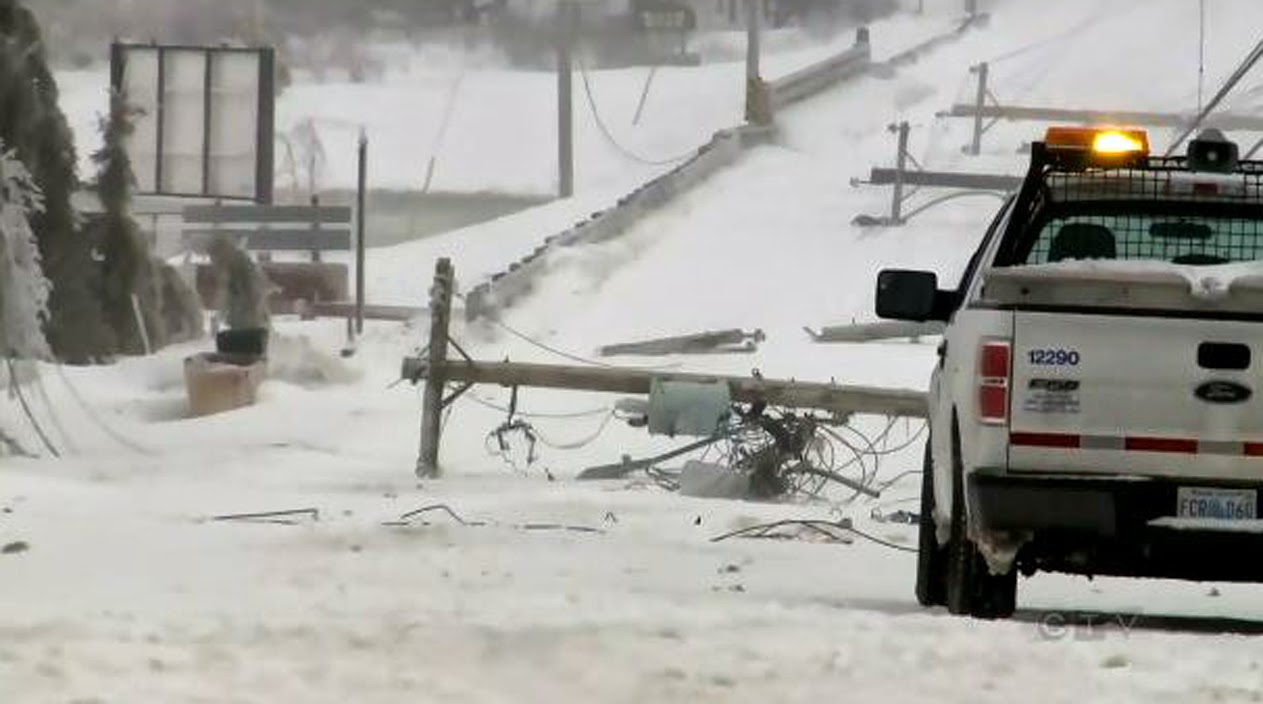
Utility crews have a big job ahead of them in the Maritimes after back to back storms brought down power lines and poles leaving thousands in the dark. (CTV News)
Such is not the case everywhere in the country. Winter is holding on in Atlantic Canada with yet another ice and snowstorm over the weekend lasting well into Tuesday. Significant amounts of freezing rain and snow have brought down power lines and poles as well as closed businesses, schools and roads. Students on PEI have not been in class for up to one week now. In several regions of the Maritimes, the plows were pulled off the roads yet again yesterday in heavy snow and blowing snow. On the Magdelen Islands, Hydro Quebec crews arrived yesterday to restore power to 1700 customers on the archipelago, out since the weekend due to heavy freezing rain and strong winds. Meanwhile in northwest Ontario, Sioux Lookout established a new April record on Tuesday with 53cm of snow in 24 hours.