Friday, August 29, 2014

Labor Day Weekend forecast

I am still having a hard time dealing with the fact it is the last weekend of the summer holiday period. A relatively new job along with other realities of life has kept me from the Atlantic coast this summer, the first time in the last 10 years. That being said I am not looking forward to what follows, with all due respect to the many who love fall. I like fall, just not as much as summer. And with that revelation it is time to take a look at the last summer weekend forecast for southern Quebec. It is a rather chilly Friday morning with 12C (54F) here on L'Ile Perrot. Skies are clear and the warm sunshine along with light winds will allow for the temperature to climb quickly to highs of 24C (76F) across the entire region. High pressure responsible for the splendid day will then move into the Gulf of Maine and set up a southerly flow of warm and increasingly humid air for the weekend. Clouds will increase Saturday with the risk of a shower or two. The humid weather will be with us throughout the holiday weekend and into the start of next week. Temperatures will be warm, near 27C (81F) along with muggy overnight lows of 18C (65F). The best chance for widespread showers and thunderstorms will come Sunday as a front interacts with the warm and moist air mass. Some of the rain will be heavy on Sunday but it will not be a washout and in fact big portions of the three day weekend may be dry. Be safe and enjoy!
NOAA Satellite image of hurricane Cristobal east of Nova Scotia early this morning.
HURRICANE CRISTOBAL
A brief update on Hurricane Cristobal located 525km southeast of Cape Race, Newfoundland at 5am this morning. The storm is racing into the north Atlantic at 80km/h. The system continues to send big waves towards the Nova Scotia and Newfoundland coasts today. Some offshore wave heights have been as much as 9 feet. Gusty north winds of 50-80km/h will develop along the east coast of Newfoundland today, but not directly from Cristobal. The winds will result from the the combination of a cold front moving across Newfoundland interacting with the circulation of the hurricane. As of 7am, a wind gust to 81km/h was reported at Cape Race. The front is also producing heavy rain, but once again this has nothing to do with the hurricane. Cristobal will merge with the front and become a large ocean storm over the next few days.

Wednesday, August 27, 2014

Despite arrival of September - warm weather will continue

Red leaves on the ground  last evening while walking my dog on L'Ile Perrot. Sorry to see the summer fading away.
The seasons are changing, there is no doubt about that. Longer nights are producing a heavy dew each morning and the trees are beginning to respond to the decline in daylight. Several of the trees here on L'Ile Perrot are changing color, especially some of the maples which typically go last. There are some vibrant reds as seen in the photo above. It has been a cooler month with officially no plus 30C days at Trudeau Airport. Unofficially I have recorded 9 such days including the last 4 in a row. Typically the airport in Montreal is cooler with lots of green space and the cooling effect off Lac St. Louis.

The setting sun illuminates this tree on L'Ile Perrot. The maples are turning early this year. (ValleyWX Photo) 
Just a few sprinkles occurred in Montreal overnight along a weakening cold front. The front did manage to produce some bigger thunderstorms well north of Montreal. Today will be partly to mostly sunny, less humid and a touch cooler with highs near 26C (79F) in Montreal. Some clouds this evening before it clears out, it will be dry and cooler with lows near 14C (56F). Thursday and Friday will be partly sunny and pleasant with highs from 22-24C and lows form 12-14C. The upcoming Labor Day weekend will be very summery with warm and humid conditions returning. Temperatures will sneak up into the high 20's with the risk of showers and thunderstorms, especially on Sunday. The warm and muggy weather will continue into next week as summer is not ready to give up just yet. With the arrival of September 1 on Monday we say goodbye to summer, at least meteorlogically speaking. Officially summer ends on September 22.

The red flags (dangerous surf & rip currents) are flying this morning along the Outer Banks of North Carolina. Hurricane Cristobal, located well offshore, is sending rough surf and swells to the coast. (OBXCams.com)
Hurricane Cristobal
A brief update on the third hurricane of the Atlantic season. Cristobal is located well off the coast of North Carolina about 525km southeast of Cape Hatteras. Heavy surf will pound the eastern seaboard over the next few days including the south coast of Nova Scotia and Newfoundland. Cristobal has (130km/h) 80mph winds and is moving northeast at 20km/h. This track will keep the storm well offshore with perhaps some gusty winds along the Grand Banks over the weekend. No direct impacts are expected in Atlantic Canada at this time.

Monday, August 25, 2014

Perfect weather to start the week in metro Montreal

With the exception of a little fog on Saturday morning, it was nearly a perfect weekend in southern Quebec. We managed to squeeze out a high temperature of 30C on Sunday, one of the few recorded this summer. The high pressure responsible for this late summer perfection will slowly slide southeast of the province today with nothing but sunshine and warm temperatures forecast. We can expect a high of near 30C (86F) in Montreal with 28 to 31C (83-88F) across the region. Another mild overnight is on tap with the return of a heavy dew and perhaps some local fog patches and a low near 18C. Tuesday will be an exact replica of today. The next chance for precipitation will come along a frontal boundary on Wednesday with showers and perhaps a thunderstorm possible.

Over the weekend western Canada was dealing with a strong low pressure area more similar to late fall than summer. Cold temperatures occurred and heavy rain fell from southern Alberta into Manitoba. Amounts were in the 50-75mm range with some minor flooding reported. It was the same to the south of the region across North Dakota and Montana. Northeast Montana is reporting flooding along several rivers this morning. There was even snow observed at the highest elevations in northern Wyoming and northwest Montana.

Cristobal
Tropical storm Cristobal developed in the Caribbean Sea over the weekend and is located about 180km off the coast of San Salvador Island in the Bahamas. The storm is moving slowly north at 6km/h with 85km/h (50mph) winds The system is forecast to strengthen into a hurricane this week, but remain offshore of the US and Canada. Heavy surf is expected along all east coast beaches this week. Strong winds and heavy rain have prompted tropical storm warnings for a portion of the Bahamas today.

Widespread damage was reported in the wine country of the Napa Valley on Sunday after a 6.0 earthquake. (CNN)
California Quake
The strongest earthquake in 25 years occurred early Sunday morning near Napa, California northeast of the San Francisco Bay area. It occurred at 3am Pacific time with a magnitude of 6.0 on the Richter scale. Widespread damage occurred with the partial collapse of several buildings as well as numerous fires ignited by ruptured gas lines. Over 150 people were injured, several seriously. Aftershocks have been reported for the last 24 hours.

Friday, August 22, 2014

Torrential rain in Eastern Ontario BUT a great weekend ahead for all

An upper level low spinning its way across eastern Ontario and into northern New York has kept cloud cover and instability largely over that region. On Thursday a few showers did develop in Montreal, but only around 6mm fell here on L'Ile Perrot, with just a trace at Trudeau Airport in Dorval. Temperatures were around 23C (73F) but it felt rather warm and muggy. All in all it was not a bad day, and we are looking at an almost identical forecast for today with just a slight chance of showers. More drenching thunderstorms are possible in eastern Ontario through this afternoon. The good news is strong high pressure will settle south into the St. Lawrence Valley and slowly drift southeast. This will set the stage for a prolonged period of sunny, warm weather from Saturday into the middle of next week. Temperatures will be very warm during the day from 27-29C (80-85F). Overnight lows will range from 12-16C (54-61F) with the chance of fog. Winds will be light.

EASTERN ONTARIO STORMS
Meanwhile some daytime heating interacting with the energy from the low produced a narrow band of very slow moving, drenching thunderstorms from the western Rideau Valley east into Kemptville and the south end of Ottawa. Rainfall amounts were very impressive with 50mm (2 inches) at Kemptville, Ontario but reports of as much as 80mm (3 inches) coming from my fellow weather watcher Jane, who lives west of Kemptville. Radar estimates and ground observations show as much as 130mm in some communities northwest of Smiths Falls and in Lanark County. The bulk of that rain fell in a deluge in a few hours during the middle to late afternoon. Creeks and rivers will respond with elevated flows over the next few days but at this time no major flooding is expected.

Winnipeg, Manitoba on Thursday after 50-75mm of rain. (TWN Photo)
Major flooding did occur in Winnipeg yesterday as thunderstorms swept that city dumping as much as 75mm of rain in just a few hours. In what has become a familiar scene this summer in many metro regions across North America, numerous highways flooded trapping motorists. There were widespread reports of basement flooding, power outages and water in one major mall.

Wednesday, August 20, 2014

Summer is not over just yet - Hurricane Camille

While walking the dog these past few mornings, it has felt like late September. The air has been cold, the dew heavy and there are even some trees starting to turn color and dare I say a few leaves tumbling to the ground. For those of us that love the hot summer weather, it has been a little disappointing in 2014, August especially. But don't give up just yet, the pattern is about to change for the last days of August. High pressure will give us sunshine today and warm highs of 27C (81F) in Montreal. This will be followed by showers and thunderstorms as early as this evening and lasting into Friday. The low responsible for the precipitation will move from the Great Lakes to off the east coast by Friday. High pressure will then build in again over Quebec for the weekend with sunshine and warm highs near 26C (79F). This weather will last well into next week with highs in the upper 20's. Indications are that the warm and dry weather will last most of next week with above normal temperatures expected through the end of the month for large regions of Quebec, Ontario and western New England.

The devastation on the Mississippi Gulf Coast was complete after the passage of Hurricane Camille in August 1969. (NOAA)
HURRICANE CAMILLE
It has been a quiet Atlantic hurricane season so far in 2014 with only 2 named storms, Arthur and Bertha. August can be quiet but it has also produced some very memorable and historically significant storms. On August 19, 1969, 45 years ago, hurricane Camille laid waste to the Mississippi Coast. The small but powerful storm is one of only three Category 5 hurricanes to make landfall on the US mainland. The storm pounded the Gulf Coast from Florida to Louisiana with 200mph winds and a then record storm surge of over 25 feet. Radar and forecasting techniques were not at the level they are today and many refused to leave there homes, some just blocks from the Gulf. The surge, arriving in the dark, wiped away entire towns during the overnight hours of August 19-20, killing over 200 people, some were never found to this day. It took decades for the economy of the region to return to what it was before Camille with damages exceeding $1.42 Billion 1969 dollars. Just two days later Camille would dump an astonishing 2 feet (over 600mm) of rain in just a few hours on northern Virginia, liquefying hillsides and washing away entire communities in water and mud. Another 120 plus people would die as a result of the flash flooding in Virginia.

During my entire life I have had a fascination with hurricanes, and Camille has always been the storm people refer to when describing just how intense and devastating hurricanes can be. She had set the bar, that is of course until Katrina in August 2005. Katrina, with a 35 foot storm surge, would kill over 1800 people, devastating the same region as Camille did but this time including metro New Orleans.

Monday, August 18, 2014

Much better weather week ahead Ontario & Quebec

Dark clouds, light rain, windy and cool with even a hint of color in the trees across the Eastern Townships this past weekend. (ValleyWX Photo)
After days of low clouds and showers we finally had a little break mid-day Sunday in the form of sunshine. Temperatures remain very chilly for August, but we did manage 23C (73F) on Sunday here in Montreal. The entire northeast as well as eastern Canada has been under the influence of a slow moving upper level low. The system produced lots of rain, very cool temperatures being dragged down to the surface from the upper atmosphere, as well as persistent cloud. On Saturday another 13-15mm of rain fell in Montreal bringing the monthly total close to 75mm (3 inches) most of that falling in the  last 5 days. Saturday was also windy and very cold for August only managing 18C (65F) here on L'Ile Perrot, feeling more like late September.

The good news is high pressure will move back into Montreal and southern Quebec today with sunshine and slightly warmer temperatures. Highs will reach the low 20's (70-73F). By Tuesday and Wednesday we may even see some middle 20's (75-80F). Lows will remain cool, for August with patchy fog around especially in the hills to the southeast of the city, temperatures will drop to near 10C (50F). By late Wednesday another round of showers is possible as low pressure moves from the Great Lakes across northern New York. At this time next weekend looks good.

Thursday, August 14, 2014

Cold windy day for Montreal - impressive rainfall totals

Several months worth of rain fell in just a few hours Wednesday morning on Islip, Long Island, NY, producing major flooding. (AP Photo)
For the third day in a row a major metro region in North America has been pounded by heavy rain and flash flooding. An entire summer's worth of rain fell on Long Island Wednesday morning just east of metro New York City. A new all time 24 hour New York state record was set at Islip, in Suffolk County after 13.27 inches (338mm) of rain fell in under 24 hours. In a two hour stretch alone during the morning commute, 9 inches fell. The rain overwhelmed the entire sewer system flooding major highways, homes and businesses. The tropical plume of moisture stretching north from the south Atlantic waters ran into a cool, fall like air mass over New England dumping the heavy rain in narrow bands across the region. By comparison New York City had only 0.5 inches of rainfall for the same period.

Meanwhile the same low pressure area brought heavy rain to eastern Ontario and southern Quebec. Over 60mm fell in Ottawa and Kemptville, with 35.2mm here on L'Ile Perrot and officially 44.4mm at Trudeau Airport. Quebec City had 62mm but it is still raining there, and south shore St. Hubert had 37mm. The upper level low responsible for all this wet weather remains over Quebec moving slowly north. Very cool air has settled over Quebec this morning with a current temperature of only 12C (54F) here on L'Ile Perrot. It will struggle to reach 17C (63F) today for a high under cloudy skies with a few breaks but also a few showers this afternoon. The same weather for Friday before temperatures moderate a little into the weekend, but still with the threat for showers. The weekend at this time looks unsettled as that stubborn low slowly weakens over northern Quebec.

Tuesday, August 12, 2014

Heavy rain on the way - flash flooding in Detroit

Above and below photos show major flash flooding in metro Detroit on Interstates 75 and 94 during last evenings commute. Nearly 5 inches of rain fell in a few hours. (WXYZ News Detroit)
 A very slow moving weather system is moving across Lake Huron this morning with a wide area of rain, some of it very heavy and thunderstorms. Yesterday major flooding occurred throughout metro Detroit and neighboring Windsor after 50-125mm (2-5 inches) of rain fell is as little as two hours late in the afternoon and evening. The rain turned the entire metro Detroit freeway system into a series of canals funneling the flood water throughout the city. Flash flooding inundated homes, business and made most highways impassable trapping motorists during the evening commute. It was the same in Windsor and Essex County, Ontario where 40-70mm (2-3 inches) of rain fell between 6 and 8pm. The water washed out streets and flooded basements.

In Montreal we managed 30C (86F) on Monday at Trudeau Airport, I had 32C (90F) at my home on L'Ile Perrot under bright sunshine. The weather will now change dramatically with the arrival of clouds and eventually rain and thunderstorms by evening from the aforementioned storm. The rain is spreading across central Ontario this morning and should arrive in Ottawa by midday and Montreal by evening. A special weather statement is now posted for all of southern and eastern Ontario for between 25-75mm (1-3 inches) of rain in the next 24 hours. The heaviest rain may move just north of Montreal and Environment Canada has posted warnings for the Ottawa Valley and the Laurentians for up to 70mm. Montreal can expect about 25mm of rain at this time, most of that late tonight and Wednesday. Temperatures will be slightly cooler today at 27C (81F) and much cooler for the balance of the week, either side of 20C (68F) for highs.

Monday, August 11, 2014

One last sunny - warm day for Quebec

It was a picturesque weekend in the Green Mountains of Vermont for the 57th Annual Classic Car Show in Stowe. The weather was sunny and close to 85F (30C). (ValleyWX Photo)
As they say all good things must come to an end and that will be the case with our weather as we start a new work week. It was a spectacular weekend with temperatures in the high 20's across southern Quebec and the rest of the region as well as abundant sunshine. The same will occur today with sunshine, just a cloud or two and warm high temperatures near 30C (86F). Clouds will start to increase on Tuesday as the high slides off the Atlantic seaboard, and low pressure with a frontal system moves northeast from the Great Lakes. Once this system becomes established over Quebec it will remain like an unwanted guest until the end of the week. Showers and thunderstorms will develop late Tuesday and become a steady rain by Wednesday and Thursday. Amounts may be significant with perhaps 25-50mm possible. A special weather statement has already been posted for the GTA and southwest Ontario where 20-40mm is forecast.It has been a dry month in many portions of Quebec with officially only 8.4mm at Trudeau Airport. The rain will be welcome but not three days worth of it. Temperatures will become cooler as well dropping into the high teens and low 20's through Friday. The good news is that by the weekend it should become fair once again along with a slow warming trend back into the mid 20's.


The great weather in Quebec was perfect for viewing the largest full moon of the 2014 season on Sunday night. The full sturgeon moon was called a super moon this weekend for its size and proximity to the earth. It appeared 30% larger and 14% bigger than normal. The moon is on its closest orbit to the earth, at 221,765 miles away. Russian Cosmonaut Oleg Artemyev took the photo above from space.

Friday, August 08, 2014

Nothing but sunshine for Montreal

A perfect summer weekend is upon us as high pressure crests over southern Quebec. Sunny days, clear cool nights are the rule through Monday. Winds will be calm and the sky almost cloud free with high temperatures ranging from 27 to 29C (80-85F) through the weekend with comfortable lows of 15-17C (59-63F). The next chance for rain will not arrive until late Tuesday as a frontal system moves into the St. Lawrence Valley. Until then enjoy the weather. I am off to Stowe, Vermont to take in the 57th Annual Antique and Classic Car Meet, one of the biggest in the region. It is hosted by the Vermont Automobile Enthusiasts. As the National Weather Service office in Burlington posted this morning in the forecasters discussion, it will be Chamber of Commerce weather this weekend.

Radar image of tropical storm Isele crossing the coast of the Big Island, Hilo, this morning. The yellow storm above is the forecast track of Hurricane Julio by late in the weekend. (Weather Underground)
Tropical Storm Isele in Hawaii
The tropical Pacific Ocean is rather active this week. The big island of Hilo in the Hawaiian Islands was pounded overnight by Tropical Storm Isele. The system is crossing the island this morning with winds close to 100km/h with higher gusts and very heavy rain up to 10 inches (250mm). Trees are down and power is out to over 24,000 homes on Hilo. But so far the damage has been light, confined to coastal regions. Hilo has never been hit by a land falling hurricane and not this time either as Isele weakened below hurricane status late last night. Isele has 60mph winds this morning and is located about 45 miles (80km) south of the city of Hilo. The storm will continue a slow westward march across the islands today at 7mph (11km/h).

Meanwhile Hurricane Julio with 120mph winds is located about 970miles east of The Big Island, Hilo moving west at 16mph (26km/h). The storm is forecast to brush the northern Hawaiian Islands by the end of the weekend. While Julio is a category 3 storm this morning, it is forecast to weaken over the weekend. It has been 22 years since Hawaii has had a direct hit from a major hurricane. This is rather historic to have two systems affect them in rapid succession.


Wednesday, August 06, 2014

Storms miss Montreal...again

Photo of what looks like a small funnel cloud late Tuesday afternoon near Beloil, on the south shore of Montreal. (Photo Kevin Avila via Quebec Vortex)
In a theme that has played out for most of this summer, thunderstorms that developed Tuesday afternoon, skirted the city of Montreal. I have not done a tally but I assure you it is no greater than 5 thunderstorms that I have seen across L'Ile Perrot this summer. Some other regions of the province, in Ontario and across northern New England have seen that in one weekend. Call it luck, good or bad depending on how you feel about thunderstorms, (I happen to like them) but that has been the reality this summer. The few showers that did dot the city yesterday afternoon produced a couple of paltry millimeteres of rain (1.6mm to be exact at Trudeau Airport, just a trace on L'Ile Perrot) and a rumble or two of thunder across the south shore. One late afternoon storm did produce somewhat of a funnel cloud near Beloil in the Monteregie, captured above. Big storms did occur once again Tuesday across eastern New York into Vermont. Pea to quarter size hail was reported south of Burlington at several locations along with heavy rain and in one report a downed tree.

Today will be much quieter across the entire NY/QC/ON region with sunshine, perhaps a few clouds and highs near 25C (77F). Increasing clouds tonight with lows near 15C (59F). On Thursday partly sunny, warmer and more humid with showers and thunderstorms developing after lunch and a high near 26C (79F). The balance of the week into the weekend looks sunny, warm (29C) and dry at this time.

Tuesday, August 05, 2014

Major flooding in Burlington, Ontario

Major flooding Monday afternoon in Burlington, Ontario. (Twitter photo #onstorm)
A series of late afternoon thunderstorms dumped two months worth of rain in several hours in Burlington, Ontario Monday afternoon. Over 125mm (5 inches) of rain was officially reported with some reports of as much as 200mm (8 inches) falling during the late afternoon drive. The storms were isolated in narrow bands along the western edge of Lake Ontario with no rain falling as little as 15 minutes away from the flooding. The result of the rain was severe flash flooding that closed numerous highways including the QEW across the western portion of the GTA. The water simply overwhelmed the small streams in the region as well as the sewers. While many cars were submerged and several drivers had to be rescued, no injuries were reported.

Thunderstorms also skirted eastern Ontario south towards upstate New York, again remaining southwest of greater Montreal. We enjoyed a mostly sunny, humid day with temperatures around 29C (85F). A cold front will approach the St. Lawrence Valley by the middle portion of the day today with an increased risk of showers and thunderstorms for Montreal. Severe weather is not expected at this time but heavy rain is always possible with any thunderstorm activity. Temperatures will reach 25C (77F) today. The showers will end this evening with skies clearing and lows around 15C (59F). On Wednesday look for a perfect day with sunny skies, dry and cooler with a high near 24C (75F).

Monday, August 04, 2014

Tropical Storm Bertha may brush Atlantic Canada

Projected path of Bertha this week. (The Weather Network)
Tropical storm Bertha is located about 220 miles (350km) east of Great Abaco Island in the Bahamas this morning. Bertha, the second Atlantic storm of this young season, has 70mph (110km) winds and is moving north at 16mph (26km) and is expected to remain well off the U.S. east coast as it becomes a hurricane later today. The storm will begin to weaken on Tuesday as it approaches the coastal waters of Atlantic Canada. At this time is is not clear just how close to the coastal area of Nova Scotia that Bertha will pass. Computer models are generating very different scenarios, but a direct hit is not expected. Rough surf/seas and heavy rains main be the main impacts to Nova Scotia and later in the week Newfoundland. Offshore waters will have storm conditions with high surf and strong winds. Warnings or a watch may be required for a portion of the region later today.

MONTREAL
The weather in Montreal over the weekend was warm and very humid, a little smokey on Saturday, with lots of thunderstorms around. The main area of storminess remained along the US/Ontario/Quebec border southwest of Montreal. Some flooding was observed in the Adirondacks of New York as storms trained over the same area both days. A few showers moved into the metro area overnight, but that should be all for today. Temperatures will be warm again today reaching 28C (83F) in Montreal. I managed two 30C (86F) days in a row at my home on L'Ile Perrot for both Saturday and Sunday. Lows tonight will be mild around 20C (68F).

The sunshine today will eventually give way to increasing clouds by Tuesday morning as a cold front moves into the St. Lawrence Valley. Look for showers and thunderstorms to develop by mid-day Tuesday. It will be cooler with a high of 23C (73F). The balance of the week looks fair, cool at first, but with a warming trend into next weekend.

Friday, August 01, 2014

Severe weather rolls over Quebec - 7th tornado

Flooding in Drummondville after 37mm of rain fell in less than 45 minutes Thursday afternoon. (Journal Express)
Strong thunderstorms swept across eastern Ontario and southern Quebec on Thursday producing the 7th tornado of the season in Quebec. The tornado struck around 4:30pm north of Quebec City with major damage reported to trees and several homes. Environment Canada estimates winds of over 150km/h. 
In Pointe-du-Lac, it was a microburst (strong downdraft produced by thunderstorms) that did the damage producing winds of 90-130km/h. Again numerous swaths of trees were downed along with power lines and damage to boats. Hail was also reported in many areas with the line of storms between Cornwall, Ontario and Louisville, Quebec. The line developed in upstate New York early in the morning and crossed the Island of Montreal around the noon hour. Winds gusted over 65km/h at Trudeau Airport, and between 12-40mm of rain fell, depending where you were in the city. In Drummondville 37mm of rain fell in less than 45 minutes flooding basements and roads.

It will be much quieter today in Montreal with just a chance of a shower late this afternoon. Sunshine will allow highs to reach 26C (79F). The weekend will be warm and a little humid with the risk of afternoon showers and thunderstorms both days. Temperatures will be near 27C (81F).

Thursday, July 31, 2014

Warm west - cool east

Waterspouts are possible over the Great Lakes again today.
It is another chilly morning here on L'Ile Perrot with the temperature sitting at 15C (59F) after an overnight low of 13C (55F) around 6am this morning. We have some sunshine around as well as some mist and fog. As I have said all week, it feels more like a September morning than late July. Sadly my favorite month of the year is over, and it will end on a cool note with highs forecast near 21C (70F). A rather vigorous upper air disturbance will provide enough lift for scattered showers and thunderstorms today as it drifts from Ontario into New England. Some of the storms may have small hail and heavy rain. On Wednesday several decent storms affected the Ottawa Valley with over 23mm of rain for the nations capital. We may see similar amounts today, but not for everyone, they will be scattered in nature. Showers will taper off this evening followed by a partly sunny Friday and a little warmer, up to 25C (77F). The threat for some thunderstorms will still exist Friday afternoon for Montreal. The weekend at this time looks sunny and warm. Let hope it holds.

The cool weather this morning stretches all the way down to the Gulf of Mexico with record lows at Pensacola, Florida of 64F and Mobile, Alabama at 63F, one degree off their coldest July morning on record. The cool air aloft has produced numerous showers and thunderstorms over the Great Lakes, several that produced waterspouts on Wednesday. The threat is there again today especially over Lake Erie. Waterspouts are similar to tornadoes but generally weaker. They can certainly upset smaller watercraft.

Meanwhile it is warm in the west with temperatures once again soaring into the middle 30's. Bow Island, Alberta hit 35.2C (96F) on Wednesday while Calgary was 32C (90F). Calgary also had a rare heat burst in the early morning hours of Wednesday. Heat bursts occur from collapsing thunderstorms. Around 1am, a gusty southwest winds hit 85km/h at the airport with a dry dewpoint of 1C (humidity was less than 15%). Meanwhile the mercury shot up to 29C (85F), almost desert like.

Tuesday, July 29, 2014

Feels like September

I am not certain where our summer went but I hope it returns soon. Officially at Trudeau Airport, Montreal has managed only four 30C (86F) days this summer, two each in June and July. Only one day over 32C (90F) has occurred, that was July 1st. Last year we managed nine 30C or warmer days in July alone.
Major flooding in Chester, Vermont on Monday. (Chester Fire Department)
 It was just a cold, miserable day on Monday across southern Quebec. Our temperature only managed to reach 18C (65F) for a high and that was early in the day. Most of the afternoon we were stuck at 16C (60F) with a cold northeast wind and rain. I recorded 11.7 mm of rain on L'Ile Perrot with a two day total of 27 mm. Other regions to our south had much more with 25-50mm (1-2 inches) falling from the Townships south into Vermont. In southern Vermont major flooding occurred around Chester and Andover in Windsor County. The rain swelled rivers damaging roads and bridges as well as several homes. Power was cut to over 1000 customers. The low pressure responsible for the lousy weather is now in northern Maine with high pressure building in briefly today. Partly cloudy skies can be expected from eastern Ontario into Montreal along with milder highs of 23C (73F), still well below normal. Wednesday and Thursday will see more clouds with the chance of a shower or thunderstorm as the upper low remains nearly stationary over the Gulf of St. Lawrence. Temperatures will warm slightly to 25C (77F) but we will have the ever present chance of a shower or thunderstorm into the weekend.


Monday, July 28, 2014

Rainy & cool start to the week

A rather vigorous low pressure area for late July is centered near Rochester, NY this morning. The system has a large area of rain and thunderstorms pivoting around it, and that area will move into southern Quebec and eastern Ontario this morning as the low moves towards Sherbrooke. It should be a rainy and cool Monday with even the chance for thunderstorms, temperatures will only be near 20C (68F) today and down to 15C (59F) tonight. The rain will be rather impressive with 25-30mm, around 1 inch generally throughout the region. Heavy rain is forecast across the Townships along with embedded thunderstorms. A rainfall warning is in effect for the Beauce and Eastern Townships where 60mm could fall. The rain should end by midnight. The rest of the week looks unsettled with showers and thunderstorms possible with a very slow warming trend.

On Sunday Montreal had about 17mm of rain, mostly in thunderstorms to start the day and scattered showers in the evening. We managed a muggy high of 25C (77F).

Thunderstorms produced major flooding in Toronto last evening with several roads impassable. (Global News)
The same system drenched southern Ontario on Sunday with 50-100mm (2-4 inches) of rain in thunderstorms. High winds cut power, trees fell on homes and cars and even a funnel cloud was reported in the southwest. Flooding occurred last evening on several major GTA highways including the 401. The OPP took to Twitter to recommend drivers stay off the roads and definitely not drive through standing water. The photo shows above some did not head that advice.

Thursday, July 24, 2014

Much cooler - less humid air arrives in Quebec

Lightning is believed to have sparked this fire in Derby, Vermont near the border with the Eastern Townships. Strong thunderstorms Wednesday brought an end to the heat and humidity across the entire region. (WCAX 3 News)
My vacation week is slowly melting away, not much going on this year as life has kept me from my usual trek to a beach...any beach. The heat and humidity that started the week has been chased out by Wednesday's cold front. Depending where you were in the region, that front either went through with a whimper or a bang. Thunderstorms in the early part of the day swept eastern Ontario, Montreal and southern Quebec with around 10-20mm of rain and frequent lightning. The storms managed to cut power to nearly 30,000 homes mostly off island in Vaudreuil/Dorion as well as in Stormont, Dundas and Glengarry County, Ontario. What had been a sultry night with temperatures in the middle 20's quickly became refreshed with the frontal passage. The same front produced heavy thunderstorms in Vermont and New York that cut power, knocked down trees and started several fires in homes. The storms were also responsible for yet another person injured by lightning this summer, this time at a campsite in Waddignton, New York near Massena.

The front pushed the hot weather to our south and east with highs only in the middle 20's in Montreal yesterday. Meanwhile the high heat was across Atlantic Canada with several record highs recorded as the mercury hit 30 to 32C. This morning Montreal is dry and much cooler at 17C (63F), quite a change from the low 30's of Monday and Tuesday. It will be a dry day with a northwest breeze and highs near 24C (75F). Clear and cool conditions expected tonight with lows around 14C (56F). Friday and Saturday look good with sunshine and highs near 26C (79F). We will see an increase in clouds on Saturday followed by a chance of showers late in the day and into Sunday. Sadly it looks cloudy, showery and cooler as we head into the last week of July. Another pool of much cooler than normal air will cross the Great Lakes and become established by early next week.

Monday, July 21, 2014

Warm & humid - strong thunderstorms Wednesday

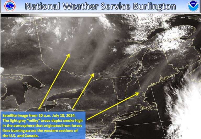
The yellow arrows show smoke over Ontario drifting into Quebec and New England late last week and into the weekend. The haze and smokey air is travelling along the jet stream from wildfires burning in Alberta and B.C. (NWS Burlington)
Well almost immediately after I guaranteed a spectacular weekend on Friday, mother nature began to challenge that claim, at least for some of us. A colder than normal air mass over the Great Lakes managed to produced afternoon clouds and even some scattered showers over Ontario as far east as the Ottawa Valley. However sunshine and only some high cloudiness prevailed in Montreal. Temperatures responded in the sunshine making it to 28C (83F) on Sunday for metro Montreal, while it was only 23C (73F) in the clouds in Toronto. Another shot of much cooler than normal air will arrive in Ontario and Quebec and the US Midwest by Thursday but until then it will be very warm and humid. Partial sunshine can be expected both today and Tuesday in southern Quebec with just some high clouds and perhaps some haze and smoke form the western wildfires. Highs will make it close to 30C (86F) both days. On Wednesday a cold front will arrive with clouds and showers along with the risk of a few strong thunderstorms. Highs will be cooler reaching 26C (79F). By Thursday sunshine will return with a much drier and more comfortable air mass and highs near 22C (72F).

The moist, unstable air has Toronto down to 1 kilometer visibility in fog and mist this morning, with a special weather statement in effect for much of southwest Ontario for dense fog. The fog should burn off in the next few hours, but until then travel is slow with visibility locally as low as zero on some highways.

Friday, July 18, 2014

Nothing but sunshine for southern Quebec & Ontario

A beautiful rainbow over the West Island of Montreal last night signalling the end to a brief shower and the start of a spectacular period of weather! (ValleyWX Photo)
 Vacation time is upon us for many and the weather looks nearly perfect. A ridge of high pressure is slowly moving across the Great Lakes and into Quebec today with nothing but sunshine, light winds and low humidity forecast through the entire weekend. Temperatures will range from 27-30C (81-86F), as I said perfect!

The high pressure in question will very slowly drift across Quebec and into New England this weekend and eventually off the east coast. The return southerly flow will increase the heat and humidity next week with highs moving into the low 30's, close to 90F by Monday. The same forecast holds true for northern New York, New England and most of southern Ontario. No rain is expected before Wednesday of next week at the earliest. Be safe and enjoy!