Friday, January 08, 2021

Long stretch of quiet weather ahead for southern Quebec

Crews plow away the 12.4cm of snow in Notre-Dame-de-L'Ile Perrot last Saturday. The relatively warm winter to date has meant very little snow across the Montreal region. Only 29cm fell in December, with 65cm for the entire season to date. (ValleyWeather Photo)

Strong high pressure over our region is being blocked from any eastward movement by an upper level low northeast of Atlantic Canada. This is forcing all the weather systems to slow to a crawl, and pushing any storms well south of our region across the southern US. So what you see is what you get for at least another week. Skies will be partly sunny all weekend, with seasonably mild temperatures. Highs will be between -1C and -5C, with lows between -6C and -10C. There may be a few scattered flurries around early next week, but no significant precipitation is in our future.

The snow drought continues in January. We managed 12.4cm last Friday and Saturday, but only a trace since, with no snow expected for the week ahead. Believe it or not, last weekends storm was the biggest snowfall this season, which is not saying much.

Before the winter of 20/21 started, it really looked like we were going to have a typical La Nina winter. La Nina, the cooling of ocean water in the equatorial region of the Pacific, usually means a mild but snowy winter for most of eastern Canada, with very cold conditions across the west.  Instead, the majority of the country has been very mild, with only sporadic snowfall.

Here in southern Quebec, we just completed one of the warmest December's in recent memory. The average temperature in Montreal was -2.1C (28.2F), 3.3 degrees above normal. Other parts of the province were even warmer, between 3.5C and 5.5C above the long-term average. In addition to the warm weather, we only managed a paltry 29cm of snow in Montreal in December. The normal is 49cm. The green Christmas in Montreal was our 5th in the last 7 years. Between 40 and 110mm of rain fell over Christmas Eve and Christmas Day across most of southern and eastern Quebec, with flooding observed in many parts of the province.

Friday, January 01, 2021

Snowfall Warning issued for Montreal

 A snowfall warning is now in effect for metro Montreal and all of southern Quebec. Snow will arrive late this evening and taper off to flurries by noon Saturday. Expect close to 15cm in Montreal. The snow may mix with sleet or freezing rain near the US border. Conditions will improve late in the day Saturday. Travel with extreme caution tonight and Saturday as roads will be snow covered and visibility greatly reduced.

Thursday, December 31, 2020

Happy New Year!


We are entering the last half hour of what has certainly been a challenging year. I wish everyone a happy and healthy 2021. Thank you so much for reading as I enter my 42nd year of weather observations in the St. Lawrence Valley.

As we head into the last 30 minutes of 2020, the weather in Montreal is clear, winds are light and the temperature is -7C (19F). I am crunching the numbers from 2020, a wild weather year to say the least, and I hope to have a blog post on the past year ready this weekend.

Be well everyone...SB

Winter storm to impact southern Quebec to start 2021

Snow from Wednesday's system covers a plowed field in Notre-Dame-de-L'Ile-Perrot on New Year's Eve. The day featured partly cloudy skies and mild temperatures, perfect for any outdoor activity. (ValleyWeather Photo)

Better late than never I guess, as the first significant winter storm of the season is set to impact southern Quebec this weekend. Up until now, the majority of the storms have either missed us outright, or delivered Montreal a messy mix of rain, with little snow. Anything over 11cm will result in the biggest snowfall, since last February.

Skies are clear on this New Year's Eve and winds have become light this evening. As a result, temperatures have dropped quicker than expected, Montreal is currently -4C (25F). The overnight low will be around -8C (17F). On New Year's Day, expect increasing clouds as low pressure and a strong warm front lift northeast from the midwestern US. High temperatures will be mild, up to -2C (29F). Any precipitation should hold off until after dark.

Snow will overspread Ontario during the afternoon hours, arriving in Montreal after 8pm. The snow could be heavy at times overnight into early Saturday morning. There is also a risk of some sleet or freezing rain mixing in, especially south of the St. Lawrence Valley. At this time, a general 10 to 20cm of snow is expected in Montreal. Winds will be gusty out of the northeast from 20-40km/h. 

Travel will be difficult across the region. The storm in question is delivering a swath of snow and freezing rain from Texas to New England. Widespread weather warnings are in effect including winter weather advisories for neigbouring northern New York and Vermont. I expect weather warnings will be issued for a portion of our region on Friday. Skies will clear out on Sunday, but another storm system is forecast for early next week. This storm however may remain south of our forecast region.

More wintry weather for southern Quebec

A rather weak weather system sill managed to bring most of southern Quebec including metro Montreal, 5 to 10cm of snow on Wednesday afternoon. After a quiet start to 2021 Friday, another storm system is set to arrive Saturday with more snow for Quebec and Ontario.

Precipitation has come to an end in Montreal, with temperatures hovering around the freezing point early Thursday morning. It is just cold enough outside for a thin layer of ice on everything, as I found out the hard way leaving the house this morning. The clipper system is now well northeast of Montreal after overperforming a touch. Trudeau Airport measured 9.2cm of snow on Wednesday along with 3.2mm of a rain/freezing rain mix. Temperatures remained below freezing until late in the evening, allowing for the extra snowfall. The very light holiday/pandemic traffic allowed for a rather easy time on area highways despite the snow.

The last day of 2020 will be partly to mostly cloudy in Montreal, along with a breezy west wind of 30 to 50km/h and temperatures steady around 1C (34F). Skies will remain partly cloudy tonight, with temperatures dropping steadily through the freezing point around midnight to morning lows of -8C (18F).

New Year's Day will be the calm before the next storm system, with increasing clouds and mild highs near -2C (29F). The next system arrives Friday night from the southern US. This storm will be tricky to forecast, as most have been this fall/winter. Expect another mix of precipitation, but perhaps with more snow than rain for Montreal. I'm still ironing out the details, but precipitation won't likely begin until after 11pm New Year's Day. I will post an update later today, but at this time, Saturday looks rather messy, with perhaps more than 10cm of snow. Temperatures will remain mild however, with no frigid air in sight.

Wednesday, December 30, 2020

Clipper delivers some snow to Montreal to end 2020

Only 18.4cm of snow has fallen in Montreal in December, well below the normal amount of 48.9cm. We will add a little to that total later today but will still fall short. It has been a very tame winter so far.

 A relatively weak weather system, an Alberta Clipper, will cross the Great Lakes and move just north of Montreal late tonight. Accompanying the system will be an area of light snow and perhaps some mixed precipitation. The low will move northeast of Montreal on Thursday, leaving behind clearing skies and mild temperatures to end the year.

Clouds have already increased early Wednesday morning across southern Quebec, and the snow is not far behind. Light snow is moving northeast across Ontario. The snow should arrive in Montreal this afternoon. Less than 5cm is expected in Montreal, with 10-20cm as you move north towards St Jerome and the Laurentians. A snowfall warning is in effect for those regions, if your commute takes you in that direction.

For Montreal, the snow will mix with ice pellets or freezing rain tonight, as temperatures warm to 1C (34F). Precipitation will taper off to a few showers or flurries early Thursday. Temperatures have cooled from out Christmas Day record high of 13.3C (56F), down to more seasonable levels over the last 24 hours. But no real arctic air is in our future, as our mild fall and winter continues.

Another storm system is set to bring us more snow late New Year's Day into the first weekend of 2021. I will post more info on the potential storm later today and on New Year's Eve.

Thursday, December 24, 2020

Wet, windy and warm Christmas for Montreal

Wednesday evening was just perfect outdoors in Montreal. Fresh snow on the ground and comfortable temperatures made it a beautiful night. Such is not the case Christmas Eve, as mild weather and heavy rain have melted away most of the snow cover leaving a soggy, muddy landscape. (ValleyWeather Photo)

Heavy rainfall warning in effect for southern Quebec.

 A deep trough of low pressure is slowly moving across the central portion of the continent, spreading a wide variety of weather along its path. A strong cold front, the leading edge of arctic air, is currently passing through the Toronto region. The front will change rain to snow as it crawls east. Behind the front, heavy snow is forecast across the snowbelt regions of the Great Lakes, including Ontario and New York.

Late Christmas Eve, low pressure is forecast to develop along the front and move north into eastern Ontario. Montreal is clearly on the warm side of the system, as we sit at 8C (47F) Thursday afternoon. The temperature will continue to rise into Christmas morning, with a record breaking high of 13C (55F) forecast for Friday. The record for the warmest Christmas in Montreal is 11.7C (53F) set all the way back in 1932. Accompanying the warm air is a swath of heavy rain. Between 30-50mm (1-2 inches) of rain is forecast for eastern Ontario and southern Quebec. Further west, the rain will change to snow Christmas Eve, with 10-15cm forecast in southern Ontario. Winds will be strong across the region, gusting between 40-60 km/h.

This storm is producing dangerous weather in many locations. Blizzard conditions occurred across southern Manitoba and northwest Ontario. In New England and New York, many of the same regions that received 100cm of snow just last week, will be receiving 50mm of rain through Friday. Widespread flood watches have been issued, with moderate to major flooding anticipated from the southern tier of New York into southern Vermont. Further south, severe thunderstorms and tornadoes are possible across the Carolinas and middle Atlantic region.

Another Green Christmas for Montreal

In Montreal, we managed 11cm of snow this week from three separate weak storm systems. Up until Thursday morning, we had our white Christmas on the ground. That is not the case any longer, as the mild weather and southeast winds have managed to melt most of the snow. The rest will disappear overnight.

Colder weather will return Friday afternoon, as the aforementioned cold front arrives in southern Quebec. Any leftover rain will taper to a few flurries, along with strong gusty west winds and dropping temperatures all the way to -10C (14F) by Saturday morning. Any wet surfaces will freeze, so use caution if out and about Christmas night.

Tuesday, December 22, 2020

Christmas storm to bring rain and wind to southern Quebec

Woodland Avenue in Verdun looking a little festive in the snow this past Sunday. The thin layer of snow in Montreal will melt away on Thursday as temperatures soar to 10C (50F). (ValleyWeather Photo)

Winter is here, officially arriving on Monday morning at 5:02. The good news is that the days will now slowly get longer. To celebrate winters arrival, we have a little light snow falling early Tuesday morning, but it remains very mild, near the freezing point in Montreal. December has certainly fooled many forecasters, while I personally expected mild weather, I also expected plenty of snow to go along with it. It just has not developed that way. The majority of systems have delivered rainy, mild weather or missed us completely to the south or west. So as we head towards Christmas, we have less than a 1cm of snow on the ground in Montreal, with only 10.8cm falling for the entire month of December. Toronto has actually had more snow this month.

Another warm storm is upon us, with heavy rain and strong winds expected beginning Thursday afternoon. An elongated arctic front will push east across Ontario on Thursday, with the front becoming the focus for deep Gulf of Mexico moisture. Heavy rain is forecast Thursday afternoon into Friday morning, with as much as 40mm possible. Low pressure is forecast to develop along the front and move north into eastern Ontario enhancing the rainfall. The low will also allow a surge of mild air in advance of the system, with high temperatures possibly above 10C (50F) in southern Quebec from Thursday into Christmas Day. Accompanying the rain will be very strong gusty southeast winds. Winds may approach 80km/h in some portions of our forecast region. Minor flooding is also possible, especially in any regions that do have snowpack.

Cold air will surge in behind the Christmas Day storm across southern Quebec, changing the rain to snow. Only minor snow accumulations are expected in Montreal. (AccuWeather.com)

As the front pulls across southern Quebec on Friday, very cold air will rush in behind it. Any leftover precipitation will changeover to a period of snow or flurries on strong northwest winds. The rain will change to snow from west to east across Ontario then Quebec. Temperatures will tumble from well-above the freezing point to -10C (14F) by Saturday morning. Any standing water will freeze over, so keep this in mind if you venture out on Friday.

There are still many details to fine tune over the next 48 hours, but I don't see this anything other than a very mild forecast for Montreal. Now quite normal for Montreal, this will be our third consecutive very green holiday season.

Thursday, December 17, 2020

Epic snowfall across southern New York & New England

An incredible record-setting 100cm (40 inches) of snow has fallen in Binghamton, New York in the last 24 hours. (Syracuse.com)

The massive Nor'Easter that dumped record amounts of snow from Pennsylvania to New England is slowly moving towards Nova Scotia on Thursday afternoon. The storm put down a general 30-60cm (12-24 inches) of snow from the central Appalachians into New England. The snow was accompanied by 50 to 90km/h winds.

The storm was epic in a swath from northeast Pennsylvania into southern Vermont, where between 75-100cm of snow fell in less than 24 hours. This included the city of Binghamton, New York along the southern tier of the state, where the largest snowfall in recorded history occurred. They measured over 100cm (40 inches) through Thursday morning and it is still snowing. Numerous roads are closed and the region is completely shut down. A state of emergency has been declared in many communities across southern New York. Closer to metro New York City, 15-25cm of snow fell. The storm will arrive along coastal sections of Nova Scotia and New Brunswick later today, with 15-25cm forecast.

A spectacular NOAA satellite image of the Nor'Easter, with an eye no less, south of Long Island, New York on Thursday morning. Montreal remained on the northern edge of the epic storm, with just clouds and gusty northeast winds. (NOAA).

In Montreal, overcast skies and gusty northeast winds were all we felt from the historic snowstorm. 

As a reference point for just how big this storm was, Montreal has only recorded 27cm of snow since November 1. Last winter, October 2019 to May 2020, we measured 204.6cm (82 inches) of snow at Trudeau Airport. That was for an entire season! Binghamton had half our seasonal snowfall in 24 hours. Many northeast cities have measured more snow since late Wednesday afternoon than they did all last winter.

Wednesday, December 16, 2020

Massive snowstorm to miss Montreal...again

The National Weather Service in Albany produced this map of expected snowfall from the massive snowstorm forecast today and Thursday. Amounts taper off quickly as you head north towards the Ontario/Quebec border. Only a few flurries are forecast for the St. Lawrence Valley.

In a scenario all too common this year, another snowstorm is missing southern Quebec, but not by much. A massive Nor'Easter is currently strengthening off the Carolina coast, poised to dump 30-60cm (1-2 feet) of wind-driven snow from Virginia to Nova Scotia. Snow has already started falling across the Appalachians and into Pennsylvania Wednesday afternoon. The snow will move across New England overnight and Thursday. Cities such as New York and Boston are forecasting more than 25cm. Winds are expected to howl across the region, gusting as high as 90km/h. Further south into New Jersey and Delaware heavy rain and freezing rain is forecast. Road closures are already occurring, with travel expected to be nearly impossible overnight tonight across the Northeast and southern New England.

The storm will move into Atlantic Canada by late Thursday and Friday. In Montreal, arctic high pressure, responsible for the coldest air so far this season, is shoving the storm south and east of Quebec. Montreal will remain on the extreme northern edge of the system, with clouds and gusty northeast winds up to 40km/h being the only impact. South of Montreal and into the Eastern Township, a few flurries are possible, with perhaps a couple of centimetres accumulation.

Montreal has basically been on the outside looking in for every storm this month. We have recorded only 4.6cm of snowfall at Trudeau Airport through December 16. The normal for the month is 48.9cm. At present we are looking at our third consecutive Christmas break, with little to no snow on the ground. Not good for any outdoor winter sports enthusiast.

Cold temperatures will prevail through the end of the week in southern Quebec. The low Wednesday morning in Montreal was -18C (0F). So far we have only managed a high of -14C (7F) under veiled sunshine. As the the pressure gradient tightens between the storm to our south and the high pressure over the region, northeast winds will increase. The gusty winds will create very cold windchills tonight and Thursday, in the -20C to -30C range. Bundle up!

Looking ahead, milder air is expected to return this weekend, along with a slight chance for some flurries or light snow. There are several opportunities for light snow next week, but nothing major at this time.

Thursday, December 10, 2020

Messy weekend storm to impact Montreal

As we witnessed Wednesday morning, it does not take a huge amount of snow to create dangerous driving conditions. A burst of snow during the morning commute lead to dozens of accidents in Montreal. (ValleyWeather Photo)

Winter is desperately trying to establish a foothold in southern Quebec. But with no real cold air in place, it has been difficult at best. The little snow that has fallen to date, including the 4 to 5cm of snow that fell on Wednesday in Montreal, melts away very quickly. Even milder air is expected on Friday, as high temperatures in southern Quebec climb to 5C (41F). Skies will tend mostly cloudy, with just  few sprinkles or flurries possible.

Marginally colder air is expected in the St. Lawrence Valley Friday night and early Saturday, with lows down to -1C (30F). On Saturday, strengthening low pressure will move towards southern Ontario and eventually down the St. Lawrence Valley. As with every storm this fall, warm air will arrive with the storm. Precipitation is expected to overspread eastern Ontario in the morning hours, spreading into southern Quebec and metro Montreal during the afternoon. At this time, it appears enough cold air will remain at the surface in to allow for a messy mix of snow, freezing rain and eventually rain from Montreal south. 

A good 10 to 20mm of precipitation if expected with this system, mostly falling as rain in Montreal, but there may be a few hours of freezing rain at the onset, especially between Montreal and Ottawa. Further north, mainly snow will fall, with 10 to 20cm possible. The amount and type of precipitation will need to be fine tuned as the event draws closer, and the path of the low becomes a little more precise. For now, plan on slick travel Saturday into the overnight hours across the entire region. By Sunday, enough warm air should change most of the precipitation to rain in Montreal and points south.

I am also watching the potential for a much larger winter storm for the middle portion of next week. There remain many details to iron out at this time.

Friday, December 04, 2020

Southwestern Quebec on edge of weekend snowstorm

Montreal will remain on the western edge of a weekend coastal storm. At this time only a few flurries are expected in the city, with heavy snow falling from the Townships eastward towards the Maine border. (AccuWeather.com)
It is yet another dreary morning in Montreal, with a light cold rain falling. The day will shape up cloudy, with scattered showers and flurries and temperatures fairly steady near 2 or 3C. The big weather news is the potential for a snowstorm this weekend. But before you get too angry or excited, depending which side of the snow team you root for, it appears the storm will miss Montreal. As was the case earlier this week, when a snowstorm impacted the lower Great Lakes and most of Ontario, sparing southwestern Quebec.

This weekends storm is forecast to move off the Carolina coast late on Friday and strengthen rapidly as it moves along the eastern seaboard and into Maine or Nova Scotia. Precipitation is forecast to spread north into New England on Saturday reaching southern Quebec by late in the day. 

At this time, it appears Montreal will remain on the extreme western edge of this compact storm. At best clouds and gusty northeast winds are expected, at the worst perhaps a few flurries. The forecast track of this storm has been all over the map, and any deviation in the final path will determine exactly where the snow falls. I expect the heaviest snow will fall from the Beauce northeast towards the Lower North Shore and the Gaspe regions. In this area 20-30cm is possible along with strong winds and blowing snow. There is also a risk of freezing rain in the Gaspe. Quebec City and Sherbrooke may receive up to 10cm of fresh snow. Portions of interior New England from Vermont south and east towards the coast are looking at 10 to 30cm of snow. If any of you still actually travel, be aware that driving will be difficult across those regions.

The storm will pull into Atlantic Canada on Sunday, with any snow tapering off to flurries. Colder air will move in behind the system on gusty north winds. Temperatures will be chilly this weekend, remining close to the freezing point for highs and down to -5C for overnight lows in Montreal.

The cool weather remains with us to start next week, with a slight warming trend towards the end of the week. No other storms are on the horizon at this time.

Monday, November 30, 2020

Montreal on the warm side of the latest winter storm

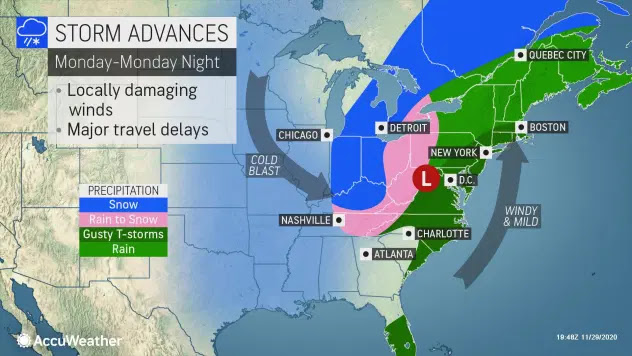
Strong low pressure will slowly move from the southern Appalachians towards Ontario over the next 48 hours, with a wide variety of precipitation. Montreal and southern Quebec will be on the warm side of the storm with rain expected. (AccuWeather) 
Strong low pressure is forecast to move from the southern Appalachians towards the Great Lakes on Monday. The strengthening storm will take a very unusual path towards western New York and across Lake Ontario before drifting west across Ontario and eventually towards James Bay. The slow moving system is forecast to deliver widespread snow and rain, along with very strong winds.

Montreal will be on the warm side of the storm for the duration of the event, with rain arriving Monday afternoon from south to north. The rain could be heavy at times Monday evening, with 15-25mm possible in the city and perhaps as much as 50mm east of Montreal. Precipitation will persist on Tuesday in the form of showers or drizzle. By the evening hours, colder air will begin to filter in on the backside of the low pressure, changing showers to a few flurries. Winds will also be very strong with this system, gusting up to 70km/h at times in Montreal and 90km/h in parts of Ontario. Temperatures will be very mild in Montreal, reaching 7C (45F) on Monday, and all the way up to 13C (55F) on Tuesday. We even have a shot at the record high for December 1, of 14.8C set in 1998.

Along and west of the storm center across southwestern Ontario, New York and Ohio, the rain will change to heavy wet snow Monday night, with 15 to 30cm possible. The hardest hit regions will be in the snowbelts of the Great Lakes, but snow is expected as well in Toronto, Detroit, Cleveland and Windsor.

The storm will be slow moving, meandering around the region through at least Thursday, with thick clouds and blustery winds. Another storm system is expected by next Saturday, with more snow and rain for southern Quebec, as the weather pattern remains quite active.

Monday, November 23, 2020

A brief return to colder weather in Montreal following the first snowfall

Another spectacular shot by photographer Steve Walsh, this one taken in Verdun. For a few moments, this gloomy November was turned into a winter wonderland late Sunday. The snow is melting away Monday morning. (Steve Walsh Photography)

The first snowfall of the season brought a few surprises along with it. The storm underperformed in southern Quebec but dumped a record-breaking 19cm of snow at Pearson Airport in Toronto. The snow spread across Ontario Sunday, arriving in southern Quebec by 4pm. The snow changed to rain in Montreal by 10pm, while remaining as mostly frozen precipitation from Toronto towards Ottawa. The early season storm brought with it the usual rash of accidents, especially across eastern Ontario where the snow was heavier. 

In Montreal, around 10cm of very wet snow accumulated, making for a spectacular Sunday night against the backdrop of an otherwise gloomy November. The snow actually seemed to pick peoples spirits up, at least until the rain arrived. This morning, we are left with a wet, slushy mess, at least here on L'Ile Perrot. We have added about 15mm of rain on top of the snowfall.

A mix of snow and freezing rain continues north and east of the city. Light snow is also falling across the Ottawa Valley. The precipitation should taper off early this afternoon, as the storm responsible lifts into far eastern Quebec.

Temperatures are very mild this morning in Montreal, sitting at 5C (41F) while Ottawa is 0C (32F) and Toronto -2C (28F). As the precipitation ends in Montreal, temperatures will begin to fall, back down below the freezing point by this evening and down to a morning low Tuesday of -5C (23F). Winds will also pick up, out of the southwest 30-50km/h. The weather will be sunny, but cold Tuesday with a high of -3C (27F).

Another storm system arrives in southern Quebec on Wednesday, with the chance for more snow.

Saturday, November 21, 2020

First widespread snow of the season forecast for Montreal

Strengthening low pressure will move along the St. Lawrence Valley late Sunday and Monday bringing Montreal the first widespread snowfall of the season. Up to 10cm may fall in Montreal, with more than 15cm north and east of the city. The snow will change to rain from Montreal south on Monday.

Special Weather Statement for Montreal for 5-10cm of snow Sunday evening.

We are in the process of cooling down early Saturday morning after another very warm high of 15C (59F) in Montreal on Friday. Our unusual November trudges along, a month that has featured an all time record high of 22.4C (73F), as well as snowfall and temperatures as cold as -7C (19F). 

On Saturday, we can expect a rather cloudy day, with slowly falling temperatures towards the freezing point by late this afternoon. Overnight lows in Montreal tonight will be cold, down to -6C in the city. On Sunday, our attention will shift to developing low pressure over the Ohio Valley. This storm is forecast to strengthen as it moves along or just south of the St. Lawrence Valley on Monday. My current thinking is snow will develop over southwestern Quebec after 4pm on Sunday afternoon. The snow will likely persist into the overnight hours before mixing with rain early Monday morning. Before the mixing, we could be looking at 5 to10cm of snowfall for Montreal, less across the South Shore and perhaps as much as 15 cm over Laval and the North Shore. There is also a chance of some freezing rain during the transition. If that occurs, it would be in the pre-dawn hours Monday morning. Expect snow covered and slippery roads for the Monday morning commute.

Gusty winds of up to 60km/h will accompany the precipitation, especially in the St. Lawrence Valley. The winds will be out of the northeast to begin with, which will help keep temperatures below freezing in Montreal. The high on Sunday will reach 0C (32F) late in the day, before rising overnight into Monday, well above freezing. Just how warm we reach on Monday, will be determined by the exact track of the storm. The current forecast high is 8C (47F), but I really believe that is optimistic. 

Mainly snow is forecast in the Laurentians and Quebec City. Weather warnings may be required for those regions. Similar snowy conditions are forecast for Ottawa and the 401 corridor towards Kingston. Snowfall totals will be 10-15cm along the Ottawa Valley, dropping to less than 5cm as you approach Lake Ontario.

Conditions will improve Monday evening, but it will turn quite cold behind the system, with lows dropping to -4C (25F). Another system will arrive late Wednesday, with perhaps more snow and rain.

Monday, November 16, 2020

Wind storm knocks out power to over 250,000 in Ontario - 10,500 in Quebec

Police and Hydro workers tend to down trees and power lines on Sunday afternoon in Kingston, Ontario. Wind gusts in Ontario reached 141km/h (86mph) and 101km/h (60mph) in southern Quebec. Across the eastern US and Canada, power outages approached 1 million customers during the height of the storm.
(
kingstonist.com photo)

Strong low pressure moved across the Great Lakes on Sunday bringing powerful winds of up to 140km/h in southern Ontario and 101km/h in Quebec. There were at least 15 reports of winds in excess of 100km/h (60 mph) in Ontario alone, including 100km/h at Toronto's Pearson Airport, 131 km/h at Port Colborne and a peak gust to 141km/h at Niagara Airport. In Quebec, the strongest wind of 101km/h occurred in the Richelieu Valley at Sainte-Bernard-de-Lacolle. In Montreal, winds were generally lighter from 40-60km/h, with a peak of 70km/h reported at Trudeau Airport. The storm also produced rain and snow, with 10 to 20cm falling across eastern Quebec including Charlevoix and the Laurentians Wildlife Reserve. I measured 10.9mm of rain here at my home on Ile Perrot, with only 3.6mm falling at Trudeau Airport.

Rare November severe thunderstorms were also reported late Sunday, adding to the wind damage across Ontario, New York and New England.

The wind created widespread damage to buildings, trees and power lines in Ontario. Hydro One reported nearly 15 percent of its grid was impacted, with a total of over 250,000 in the dark in Ontario alone. Many remain without power on Monday. The wind also swept across the US side of the lakes with over 500,000 homes and businesses without power from Michigan to New York. In Quebec, Hydro-Quebec reported 10,500 customers without power as of Monday morning.

In addition to the power outages, the wind toppled hundreds of trees and branches, many onto homes and cars. The water on Lake Erie was whipped into a frenzy, with reports of waves in excess of 15 feet. Storm surge flooding occurred on the northeast side of Lake Erie, including in Buffalo, Port Colborne and Fort Erie. The surge reached over 9 feet in some locations along the shoreline.

The wind remains gusty in Montreal on Monday, as the storm pulls into northern Quebec. Cooler temperatures will return this evening, with showers changing to flurries overnight. Temperatures will drop down below freezing Monday night, with a forecast low of -3C (27F) in Montreal.

Sunday, November 15, 2020

Classic Great Lakes fall storm to impact Ontario & Quebec

Wind Warning posted for the Richelieu Valley

Freezing Rain Warning for Ottawa and west Quebec

A classic "November Witch" fall storm will sweep across the Great Lakes today. Powerful winds between 70-120km/h are forecast for large portions of southern Ontario and southwestern Quebec. Precipitation in the form of snow and rain is also forecast. Montreal will have above freezing temperatures and can expect mainly rain with 10-15mm expected. Behind the storm, gusty winds and flurries will persist most of the day on Monday.

Strengthening low pressure is forecast to move across the Great Lakes on Sunday and into far western Quebec. The storm will bring a wide variety of active weather from snow and freezing rain across the north, to powerful winds and rain across the eastern Great Lakes and into the St. Lawrence Valley.

The first round of precipitation early Sunday morning, is encountering temperatures that are slightly below freezing in the Ottawa Valley and portions of western Quebec. A freezing rain warning has been issued for those locations. Expect 1-3mm of frozen precipitation, before temperatures rise above freezing. The rest of us, including metro Montreal, will see showers, beginning late this morning and tapering off this evening. As cold air moves back into the area overnight, there is a chance for a few flurries before morning.

The big story with this storm will be strong to severe wind gusts. In the Montreal region, we are expected to be on the edge of the strongest winds, with gusts to 70km/h possible in the city later this afternoon and this evening persisting into Monday. Regions southeast of metro Montreal in the Richelieu Valley can expect gusts to 90km/h. A wind warning has been posted for that area by Environment Canada.

Southwest of Montreal along the St. Lawrence Seaway and especially on Lakes Erie and Ontario, winds could easily reach 90km/h with gusts on the open waters of the Great Lakes approaching hurricane strength of  120km/h. Storm warnings have been issued across the Great Lakes. Waves on the open water are expected to be between 8 and 15 feet, capable of submerging smaller boats. There is also an increased chance of lakeshore flooding in the shoreline communities along both sides of the international border. Power outages and tree damage are also possible, especially across southern and eastern Ontario.

Conditions should begin to improve on Monday as winds ease during the afternoon hours. 

Friday, November 13, 2020

November heatwave comes to an end for Montreal

The sunset on Tuesday, November 10 was spectacular, fitting for the warmest November day ever recorded in Montreal. (ValleyWeather Photo)

Colder weather has returned to southern Quebec after our remarkable stretch of warm weather. Conditions were similar to late summer then mid-November. By the numbers it was very impressive. There were dozens upon dozens of new record highs established from central Ontario to Atlantic Canada. Many locations also recorded their warmest November temperatures ever. 

In Montreal, we established seven new weather records between November 5 and 10. Records highs were established on November 5, 9, 10 and 11th. On November 10th, not only did we set a daily record, but the high of 22.4C (73F) was the warmest November temperature ever recorded in the city. This surpassed the previous high of 21.7C (71F) set on November 6, 1948. Tuesday's high also represented the latest in November that a 20C temperature has been observed in Montreal. The entire stretch of warmth established another record for the longest 15C plus stretch in the city since record keeping began in the 1870's. Accompanying the warm weather was brilliant sunshine, with some of the most spectacular sunsets I have seen this year.

While we have been enjoying late summer warmth, the southern Prairies have been shivering in biting cold and wind-driven snow. My good friend and Publisher of the Gravelbourg Tribune, Paul Bosivert, sent me this photo of deep snow on
Main Street in Gravelbourg, Saskatchewan. The photo was taken
after the storm subsided on Monday, November 9. 

While all this was playing out in eastern Canada, western portions of the country from B.C. to Manitoba have been plunged into mid-winter conditions. Heavy snow, strong winds and arctic cold have dominated the weather most of this week. The weekend blizzard closed large stretches of highway in southern Alberta and Saskatchewan. Temperatures are slowly returning to normal out west as they are here in southern Quebec.

COLDER WEATHER RETURNS

As I take a peak into the future, it appears our warm weather is over. But that does not necessarily mean we will have bone-chilling cold. Temperatures will settle back within range of the normal high of 5C (41F) and low of -2C (28F). For the upcoming weekend, sunny skies will prevail on Saturday, before a strengthening Great Lakes storm brings us rainy, windy weather for Sunday. By early next week, some of the coldest air of the season will settle into our region, bringing us below freezing temperatures for daytime highs by Wednesday.  Accompanying the cold will be some light snow or flurries. It is too early to tell if we will have some accumulations, but it is possible. Near to slightly below normal temperatures are expected to persist through the end of the month.

Sunday, November 08, 2020

Record warmth for eastern Canada - blizzard for the Prairies

A spectacular November sunset on the South Shore of Montreal on November 6. The weather across southern Quebec has been more like late summer than late fall. (Valley Weather Photo)

What a spectacular weekend it was across southern Quebec and Ontario. The weather was more like early September than mid-November. Numerous record highs were established from Ontario to Atlantic Canada. Here in Montreal the high both Saturday and Sunday was just shy of the 20C (68F) mark although some parts of the city, including here on Ile Perrot, hit 21C (70F). The record for both Saturday and Sunday was 20C established in 1975. Trudeau reached 19.8C Saturday and 19.3C Sunday. Montreal did manage a record high on Thursday, when the mercury hit 21C beating out the 1988 record of 19C. 

We are in for two more very warm days, with highs near 21C on Monday and Tuesday. The records to beat in Montreal are 19.4C set in 1945 for Monday, and 18.3C set in 1948 for Tuesday. This continuous stretch of very warm weather in the longest for any November since record keeping began in Montreal. The normal high for early November should be 7C (45F) and the low -1C (30F). Even the overnight periods have been very mild, only dropping to around 10C (50F).

We can thank strong high pressure anchored off the east coast of the US for the fantastic fall weather. The high will slide east by Wednesday, allowing a frontal system to move into our region. The front will tap into some moisture from the remains of hurricane Eta. Expect showers to develop late Tuesday or early Wednesday, and persist most of the day. Behind the front, we can expect clearing skies on Thursday, along with more seasonable temperatures. Highs will drop down to the single digits, with lows back below freezing.

Prairie Blizzard

While we have been enjoying a late taste of summer here in Montreal, winter weather has returned to western Canada. A strong winter storm has produced heavy snow and  high winds across Alberta and Saskatchewan. Many locations have reported over 30cm of snow, accompanied by winds of up to 90km/h. In Edmonton 20 to 40cm of snow fell Saturday, while a peak wind gust of 102km/h was observed at Ardenville. The snow was preceded by several hours of freezing rain in eastern Saskatchewan. Numerous roads are closed, including the Trans Canada Highway from Swift Current to the Alberta border. Blizzard warnings have been posted. The storm will taper off on Monday. Temperatures have plummeted in advance of the storm, down into the minus teens.

Catastrophic flooding in the wake of Hurricane Eta has resulted in over 150 deaths in Central America. The storm, the strongest of the 2020 season to date, has weakened from the once Category 4 powerhouse and is now heading for south Florida. (CBC)

One final weather note is hurricane Eta. Eta was a powerful category 4 storm when is smashed into the Nicaraguan coast on Tuesday, November 3. The storm has produced catastrophic flash flooding across Central America, with hundreds of fatalities reported. River flooding and landslides occurred after 300-500mm of rain fell. Eta emerged back into the Caribbean Sea on Saturday, regaining tropical storm strength, with 100km/h winds.  On Sunday evening, the storm was located 225 kilometres southeast of Miami. Eta will sweep across the Florida Keys overnight and move into central Florida on Monday.

Sunday, November 01, 2020

Winter weather for 36 hours followed by a warming trend

The first snow fell last Monday in parts of southern Quebec, mainly outside of Montreal, including Rougemont, shown above. More snow can be expected to start this week. It will feel like winter is here to stay, but much warmer weather returns by Wednesday and persists well into next week. (Photo: T. Giotsalitis)

Southern Ontario and Quebec including metro Montreal, can expect a potent shot of winter weather over the next 36 hours or so. A strong cold front will cross the region Sunday evening, followed by weak low pressure late Monday. Showers Sunday evening, will mix with and change to flurries across the region. Montreal can expect temperatures to drop to the freezing point early Monday morning and remain there into Tuesday morning. Strong winds of up to 60km/h will make it feel even colder. In terms of accumulations, a dusting to perhaps a few centimetres is possible for the city, especially across the highest elevations around Montreal.

The cold air will also generate heavy lake effect and mountain snow showers. Some locations downwind of Lakes Huron and Ontario will see a significant lake snow event with up to 30cm possible. Widespread weather warnings are in effect. Heavy snow is also possible south of the lakes across western New York including parts of Watertown and Buffalo.

We can expect a false start to winter this week, with snowy, cold and windy weather through Tuesday. (AccuWeather.com)

In the Eastern Townships of southern Quebec as well as the Green Mountain and Adirondacks, 10 to 20cm of snow is possible throughout the day Monday and into the evening hours. The heaviest snow would likely be Monday night. Expect poor travel conditions along portions of Highways 10 and 55 around Sherbrooke. A special weather statement has been issued for that region. Tuesday will be blustery and cold across all of southern Quebec, with daytime highs around 3C (39F).

WARMING TREND

After a cold start to the day on Wednesday, a warm front will lift north across the St. Lawrence Valley. This will be the start of a prolonged period of very mild temperatures with little precipitation. The warm and dry weather will persist into next weekend. Daytime highs will rise above normal into the middle teens. The above normal temperatures are expected to continue well  into the second week of November.