Monday, September 08, 2025

Another stretch of dry weather ahead for southern Quebec

The Suburban, along with Tanguay, held our second annual Family and Pet Day in Cote St-Luc on Sunday. This was a rain date from August 24, when the threat for thunderstorms made it unsafe. Thankfully for the many in attendance, the rain held off this time, with the exception of a few menacing black clouds and gusty winds, along with an isolated sprinkle or two. (Valley Weather)

Strong high pressure has settled into southern Quebec on Monday morning, and will slowly drift southeast over the course of the upcoming week. This will result in another stretch of sunny and dry weather for our region. Temperatures have started off cool Monday morning, with many locations in the single digits, including 9C (48F) at Trudeau Airport. 

Montreal will warm to near 20C (68F) Monday and well into the middle 20's for the balance of the work week, with nothing but sunshine expected. The overnight period will feature clear skies, and cool temperatures, either side of 10C (50F).

The lack of precipitation this summer has resulted in drought conditions across many parts of southern Quebec, especially in the eastern portion of the province as well as Ontario and Atlantic Canada. (ECCC)

The next chance for rain will not come before the upcoming weekend. While the pleasant late summer weather is welcome by many, the area remains excessively dry. Large portions of Canada are actually in one stage or another of drought. In August, most of Quebec had below normal precipitation, with the deficit ranging from 25 to as much as 100 percent below the long-term average. The rain that has fallen in Montreal has often been too much at once, with too many days in between events.

We did manage a few millimetres of rain over the weekend, bringing Montreal up to 21.4mm for the month, but that amount remains below the long-term average to date for September. Southern Quebec needs a slow, soaking rain. Nothing is on the horizon at this point.

Friday, September 05, 2025

Strong winds cut power to over 70,000 homes across southern Quebec

Hydro-Quebec crews are on the ground Friday morning, repairing damage caused by a gusty cold front that moved across southern Quebec late Thursday. At the height of the outages, more than 70,000 customers were in the dark. That number is down to just under 40,000 Friday morning. (Hydro-Quebec)

A fast moving cold front generated strong winds late Thursday afternoon, cutting power to over 70,000 Hydro-Quebec customers across the southern part of the province. This included close to 4400 in the Montreal region. Hardest hit were the Laurentians and Monteregie regions. Early Friday morning, just under 40,000 customers remained without power. A majority of the outages were caused by downed tree branches coming in contact with wires and transformers.

The strong late-summer cold front dropped temperatures from a daytime high of 29C (85F) in Montreal, down into the upper teens in a matter of minutes around 5pm. A few heavier showers and embedded thunderstorms produced a gust front, with winds briefly in the 60-100km/h range locally. Officially at Trudeau Airport, the wind gusted to 63km/h. There were no weather warnings in effect at the time of for the front. Some much need rain fell as well, with 17.8mm recorded at Trudeau Airport, while I measured 11mm at my home on Ile Perrot.

We can expect a calm, sunny Friday, with a warm high near 24C (76F). Winds will increase during the afternoon hours once again, gusting between 20-50km/h. On Saturday, an upper level low will drift over the region, with a cool, breezy and showery day expected, the high will only be 17C (63F). Sunday at this time looks fair, with some cloudy periods and perhaps an isolated afternoon sprinkle or two. The high will be 20C (68F).

Thursday, September 04, 2025

Welcome to Meteorological Fall

September skies can be spectacular as Summer begins to give way to Fall. This vivid rainbow developed late Tuesday afternoon after some isolated showers and thunderstorms moved across Ile Perrot and the West Island of Montreal. (Photo: Valley Weather)

Well fall arrived September 1st, at least according to the meteorological community, astronomical autumn will catch up on the 22. September has started off warm, with well-above normal temperatures since Labour Day Monday. Clouds are on the increase as I write, with a strong cold front to our west. While Montreal is at 23C (73F) as of 10:30AM, Toronto, behind the fall-like front, is down to 12C (54F).

The front will produce some gusty southwest winds today, up to 50km/h, along with some thunderstorm activity later this afternoon. A period of steady rain Thursday evening, will taper off by morning, with a fair and warm day forecast Friday.

The cooler air will eventually arrive in Montreal, but it may take a day or so. Another slow moving cold front and upper level low will bring us showers and thunderstorms Saturday. On Saturday, the core of the colder air will arrive, along with showers and a high of only 17C (63F). Sunday into early next week will feature cool nights, with seasonable days along with fair weather through Wednesday.

Our hot and dry summer is now in the record books. In June, only 22mm of rain fell at Trudeau Airport. That was followed by 133.1mm in July, but most of that fell in a few hours on the 13th. August was the hottest month this summer, with 7 days over 30C (86F), including a 6 day heatwave, and the warmest temperature this summer for Montreal,  35.1C (95F). The heatwave included 3 record highs. Montreal managed 70mm of rain, but most of that fell during the last few days of the month. In fact, only 7 days has measurable rainfall at Trudeau Airport.

September heralds the change of seasons. The skies can be dynamic as one season yields to the next. Indications are we can expect temperatures and precipitation fairly close to normal. We will lose nearly 90 minutes of daylight in Montreal from the start to the end of the month. The trees are already showing signs of colour. The fall foliage may be greatly diminished this fall, as many trees are showing signs of heat stress, which can limit the colours.

Thursday, August 28, 2025

Slow moving cold front bringing much needed rain to Montreal

A slow moving cold front has been lying just to the northwest of Montreal all day Thursday. That front will finally press southeast this evening, bringing with it a decent 15-25mm of rain for the Montreal region. Friday will be breezy, cloudy and cool, feeling very much like Autumn across southern Québec.

It has been a dry month and a dry summer. To date, Montreal has measured 41.2mm at Trudeau Airport this August, most of that falling on just a couple of days. This is well below the long-tern average for the month of 93.6mm. The lack of rainfall has been evident, with watering restrictions, dangerously low levels on area lakes and rivers and heat stress reported to crops, tress and even your lawn.

Thursday afternoon we are watching a very moist and achingly slow moving cold front draped from southwest to northeast, located just north of Montreal. This front is the dividing lone between a fall-like airmass and warmer more humid air to the south. As I write, Montreal is 24C (76F), while Ottawa is only 17C (63F). Along the front steady rain is falling, with a few rumbles of thunder.

That front will begin to affect the Montreal region late this afternoon and especially this evening and overnight. Steady rain will persist into the morning hours on Friday along with cooler temperatures. Rainfall amounts will settle into the 15-25mm range. Not a drought-buster, but certainly helpful.

Overnight lows will drop into the teens, and as winds back to the northwest, temperatures will struggle to rise on Friday under cloudy skies reaching near 17C (63F).  Saturday will be cloudy and cool as well, feeling more like September. But the news is not all bad for the long holiday weekend, with sunshine expected both Sunday and Monday, with daytime highs rebounding into the middle 20's. Nearly perfect late summer weather for the Labour Day holiday.

Thursday, August 21, 2025

Hurricane Erin pounds the Eastern Seaboard with high surf

Pounding surf from Hurricane Erin inundates homes in Buxton, North Carolina along the coast of Hatteras Island on the Outer Banks. Despite being over 300 kilometres form the coast, Erin has produced significant flooding and some structural damage. (WTKR)

Category 2 Hurricane Erin was located 340km east of Cape Hatteras early Thursday morning, with 165km/h (105mph) winds and a central pressure of 945mb. The large and powerful storm sent towering waves crashing into coastlines from the Carolinas to Nova Scotia, producing coastal flooding and dangerous rip currents. Mandatory evacuations were in place for Hatteras and Ocracoke Islands on the Outer Banks of North Carolina, where State Highway 12 was closed due to ocean over wash and significant flooding over several high tide cycles. Some structures have already been damaged. 

Erin is a large storm, stretching over 1200 kilometres in  diameter, with hurricane force winds extending outward165km from the centre, and tropical storm force winds an incredible 520km from the eye.

On Thursday morning, Erin was located 340 kilometres to the east of Cape Hatteras. The storm was forecast to race off to the northeast today passing south of Atlantic Canada on Friday. Heavy surf is forecast from the Carolina's to Newfoundland for the next 36-48 hours. (Windy.com)

For those of you who frequently read my blog, you are aware of my passion for the Outer Banks. I had been vacationing their since 1991. During my last trip in 2018, I sat under Jennette's Pier in Nags Head, with my dog Bella. It was her last trip. Our time their was spectacular. Today, the Pier is reporting a wind gust to 87km/h, with a 2 to 4 foot surge and towering waves. Not an ideal beach day to say the least.

Erin will continue to produce coastal flooding along the Outer Banks, spreading north into Virginia and the Middle Atlantic States. Later today, gusty winds and heavy surf will move into the Northeast and New England including Long Island and Cape Cod. 

Earlier this week, Hurricane Erin produced heavy rain and flooding in Puerto Rico. At the time, Erin was a powerful category 5 storm, with winds in excess of 160mph. (Unknown Facts)

The heavy wave action will begin to impact the south facing coast of Nova Scotia and Newfoundland Friday and into the upcoming weekend before Erin races off to the northeast. Winds may gust to 70km/h along the Nova Scotia coast late Friday and Saturday. Gale to storm force winds are expected in the offshore marine waters of Newfoundland, with seas building to 8 to 10 metres (26-33 feet) by Saturday.

The tropical Atlantic will continue to remain active, with the National Hurricane Centre watching two more areas for development as we head into the peak part of the season.

Sunday, August 17, 2025

A taste of autumn for Montreal

A NOAA satellite image showing powerful hurricane Erin Sunday afternoon, located northwest of Puerto Rico. The storm should stay away from land, but will grow in size, sending towering waves towards the Eastern Seaboard and Atlantic Canada coastline this week. (NOAA/NHC)

And just like that, mid-summer weather became September-like in less than 6 hours. If you needed a break from the intense heat, you will have one this week. Montreal did manage another 30C (86F) day on Saturday, before a strong cold front swept across the region early Sunday morning. The front was accompanied by gusty northeast and eventually northwest winds, some much needed rainfall and rapidly falling temperatures. By mid-morning, the mercury had fallen to 15C (59F) here on Ile Perrot.

A decent 11.6mm of rain fell along the front at my weather station on Ile Perrot, but we need more to alleviate the dry summer we have had. Watering restrictions remain in place for several communities on the West Island as well as Vaudreuil-Dorion and here on Ile Perrot. 

The fall-like airmass that moved into southern Quebec will be with us for most of the upcoming week, a big change from the hot and humid weather that has persisted for most of the summer. Late afternoon sunshine did allow the temperature to rebound Sunday, close to 21C (70F) as I write this update. We can expect clear skies overnight, with cool lows in the upper single digits to around 12C (54F) in downtown Montreal. Monday will be fair and cooler, with a high of 21C. Clouds increase Tuesday as another frontal system approaches southern Quebec. 

The Canadian Hurricane Centre forecast track of Erin as the storm turns north this week and approaches Canadian offshore waters. (CHC/Environment Canada)

Hurricane Erin

Erin became the first Atlantic hurricane of the 2025 season on Saturday, strengthening into a major Category 5 storm, with 255km/h winds, less than 24 hours after forming. Thankfully, the catastrophic strengthening occurred far from land. 

Erin has since weakened slightly to a Category 3 storm, with winds of 205km/h as of 5pm Sunday afternoon. Erin was moving west northwest at 20km/h, with a forecast turn to the northwest and eventually north expected. The center of the storm was located 445km northwest of San Juan, Puerto Rico, with a barometric pressure of 946mb.

To date Erin has avoided any direct impacts to land, but her size and strength has spread heavy rains in Puerto Rico. Erin is expected to continue to grow in size and may deepen once again as the storm moves offshore of the United States east coast and eventually moving southeast of Atlantic Canada my the end of the week. Heavy surf and rip currents are forecast to spread from Florida to Newfoundland this week.

At this time, a tropical storm warning is in effect for the Turks and Caicos Islands as well as the southeastern Bahamas, with Erin producing strong winds and heavy rain as it brushes this region Monday. All interests from the Carolinas to Atlantic Canada should monitor the progress of hurricane Erin this week.

Hurricane Erin will have no impact on the weather here in southern Quebec.

Thursday, August 14, 2025

Slightly cooler - less humid weather for Montreal

The sudden heavy rain on Wednesday ended a month long dry spell in most locations across the Montreal region. The rain resulted in a white, foamy substance forming that but made roads extremely slippery at the onset. That combined with low visibility resulted in several accidents. The foam was a result of a lack of rain producing a significant buildup of oils and other contaminates on road surfaces.

The historic heatwave is over for Montreal, after six 30C (86F) plus days in a row, the high Wednesday reached only 29C (85F). More importantly, rain fell on the region. Strong thunderstorms swept across the Island of Montreal, producing heavy rain, strong winds and plenty of vivid lightning during the morning hours Wednesday. It had been bone dry for nearly a month in Montreal, but 19.4mm fell at Trudeau Airport during the morning storms, with amounts across our region ranging form 7mm to 20mm. Certainly not a drought buster, but more than welcome.

The rain has improved the wildfire risk in southwestern Quebec, but conditions remain poor southeast of Montreal across the Townships and Beauce regions. You can add Hudson to the growing list of communities that have watering bans in effect. Water levels remain low on all area waterways, so conservation is key at the moment whether or not your community has restrictions.

As far as temperatures are concerned, the weather will remain warm, with highs between 28C and 32C (85 to 90F) through Saturday. On Sunday, a much stronger cold front arrives, with showers and thunderstorms followed by a significant pattern change that will allow much cooler air to settle into southern Quebec next week. More on that in later posts. 

We also need to watch closely Tropical Storm Erin, which is forecast to develop into a major hurricane by late in the weekend. Erin is still far away, located 1595 km east of the Leeward Island on Thursday morning, with 85km/h winds. The storm is no threat to land at the moment.

The most recent heatwave established a ton of record highs across eastern Canada. Some locations, such as Newfoundland and Prince Edward Island recorded their hottest days ever. In Quebec, Gaspe Airport reached 36.2C (97.2F) on Tuesday, the warmest day ever recorded at that location dating back to 1915. It surpassed the previous high of 36C (97F) set back in 2003.

In Montréal, our string of 30C days this summer has now reached 17, well-above the seasonal average of 9. Many of those have been above 32C (90F) and two above 35C (95F). Overnight lows were warm as well, breaking several records this summer.

Wednesday, August 13, 2025

Historic heatwave coming to an end in Montreal - thunderstorms likely

Another hot sunset in Montreal. The excessively hot and dry summer has taken a toll on trees and vegetation in the region. Many are showing signs of significant heat stress and lack of moisture. The hot weather has been historic in many parts of eastern Canada, with dozens of new temperature records established from Ontario to Newfoundland. Relief is on the way for southern Quebec Wednesday.

Severe Thunderstorm Watch issued for Montreal

The historic heatwave that has gripped the eastern part of Canada for nearly a week now will come to an end in Montreal Wednesday. A cold front is moving across Ontario as I write, with showers and thunderstorms developing in advance. Some of the storms may be on the strong side, with gusty winds and heavy rain the main threat. We need the rain, let's just hope it does not come all at once.

Tuesday was another sweltering day, with a record-breaking high of 34.6C (94.3F) at Trudeau Airport. It was the third consecutive day with record heat following Sunday's 34.4C (94F) and Monday's 35.1C (95F). Overnight lows have remained in the low to middle 20s. Montreal was still 29C (85F) at midnight early Wednesday.

Patly sunny skies Wednesday morning will give way to clouds, showers and thunderstorms through the noon hour and into the evening. Temperatures will be warm again today, reaching 30C (86F) before the rain. It will be a muggy day. The air behind the front will be cooler and less humid, with highs in the middle 20s expected Thursday and Friday.

The heatwave has resulted in watering bans being issued for several communities across southern Quebec. The wildfire risk has been high as well, with numerous significant fires being reported in Ontario and across Atlantic Canada and Newfoundland.

Dozens of new record highs were established over the last few days. Badger, Newfoundland reached 36.7C (98F) on Tuesday, a tie for the warmest temperature on record for the province. Miramichi, New Brunswick reached 38.6C (101.5F).

Montreal is also moving up the list for the warmest summer on record. As of Tuesday, we had recorded 10 days of 32C (90F) or higher. That places us fifth in the record books behind the 14 days recorded back in 2020. 

The heatwave has sadly resulted in at least one heat-related death in Montreal, and there have likely been others. The prolonged effect of days of high heat is taking a toll on many. The cooler weather and rain will be more than welcome.

Monday, August 11, 2025

Record warmth for southern Quebec through Tuesday

The weather was hot for the Annual Firefighters Day Parade in Pincourt on Saturday, August 9. Spectators lined the streets of the municipality as First Responders and emergency vehicles slowly passed by. The event has been hosted by the Pincourt/Notre-Dame-de-L'Ile-Perrot Firefighters since 1980. Departments and Agencies participated from the Island of Montreal, across the Monteregie and even eastern Ontario. (Valley Weather Photo)

Heat Warning remains in effect for southern Quebec and eastern Ontario.

The warmest air of the summer has settled over the region. Strong high pressure anchored off the eastern seaboard will continue to pump hot and increasingly humid air into southern Quebec to start the work week. The result will be a long period of very warm temperatures along with elevated humidity. With highs in the 30s and humidity readings near 50 percent, humidex values will easily climb through the 30s to near 40C (104F) each afternoon. Overnight lows will remain very warm in the low to middle 20s.

This type of heat is extremely dangerous, especially for the very young, seniors and pets. Stay hydrated, and limit outdoor activities to the early morning hours or near sunset. Find relief in air conditioned buildings such as malls or theaters. Montreal has plenty of shady spots by the lake or river, which offers some slightly cooler air.

Monday will make this an official heatwave in Montreal as the temperature will soar above 30C(86F) for the third consecutive day. On Saturday, Montreal reached 32.3C (90F), while Sunday we warmed even more, with a record high of 34.4C (94F). That surpassed the long-standing 1914 record for the date of 32.8C (91F). Montreal should be even warmer on Monday and Tuesday. The forecast high today is 34C (94F), the record for the date is 35C (95F), set back in 1944. On Tuesday, Montreal is expecting a high of 35C (95F), which should easily break the 2002 record of 32.7C (91F). 

Another concern of the recent heatwaves has been the lack of rainfall. Gardens, crops and trees are starting to show signs of drought and heat stress. Since July 19, Trudeau Airport has recorded only 2.8mm of rain. No rain has fallen in August to date. Vegetation is tinder dry and any outdoor fires are not recommended and in some cases banned all together. Check with your municipality or better yet just don't do it. Most wildfires in Quebec are a result of human activities, such as the burning of trash, discarded cigarettes or campfires.

According to SOPFEU, the fire danger Monday and Tuesday ranges from very high to extreme across the southern and western portion of the province. The same is true across parts of Ontario east to Atlantic Canada. Several significant brush fires have been reported in those regions. Remain vigilant.

Some relief arrives Wednesday in the form of a weak cold front. A few showers are possible. 

Thursday, August 07, 2025

Extended period of hot and dry weather for southern Quebec

Less than 1mm of rain has fallen in Montreal during the last three weeks. Lawns are turning yellow and leaves are falling as moisture starved vegetation reacts to the extremely dry conditions. Hot and dry weather is forecast through Tuesday for the St. Lawrence Valley. (ValleyWX Photo)

UPDATE: Saturday, August 9, 6:30PM: Heat Warning issued for metro Montreal.

This has certainly been a hot and dry summer, briefly interrupted by two flooding rain events. If you take a look at Montreal since the start of meteorological summer on June 1st, 155mm of rain has fallen. Not bad right? Break it down and it explains why lawns are turning yellow and leaves are falling from moisture starved trees. In June, only 22mm of rain fell. July was better, with 133.1mm, however, most of that fell on two days, including the flash flooding event of July 13. The lack of frequent precipitation has often been accompanied by searing heat.

August has had no precipitation to date at Trudeau Airport. In fact, only 0.6mm of rain has fallen in the last 20 days. That trend is forecast to continue, with only widely scattered, mostly elevation dependent showers through Tuesday. Here in the St. Lawrence Valley, we are expecting hot and dry weather, with temperatures and eventually humidity levels on the rise.

A grass fire, started by a combine, burns in Leeds and Grenville County in eastern Ontario this week. The dry weather extends from the Prairies into Atlantic Canada. In many parts of Ontario, water and outdoor burn bans are currently in effect as the fire danger remains elevated. (OPP East Photo)

Thursday will be sunny as high pressure builds across the region and extends to our southeast. As that high pressure moved to our east, temperatures will begin to rise. Highs will range from 29C (85F) Thursday, into the low and even some middle 30s by Monday. Overnight lows will be on the rise as well, from the middle teens Friday into the low to even middle 20s in urban areas by Sunday night.

The next chance for any rain or thunderstorms will not come before late Tuesday as a cold front moves southeast from Ontario.

The dry weather has prompted outdoor burn bans for a large part of southern and eastern Ontario. So far in Quebec, the only region with very high to extreme fire risk is the Gaspe region. That may change. Best advice is to avoid burning anything outdoors as most vegetation is significantly lacking in moisture. 

The dry weather extends across a broad region of Canada, with fires burning from Alberta to Newfoundland. So far Quebec remains fortunate, with only 5 active fires according to SOPFEU. This has allowed the province to send firefighters and equipment to Alberta, Saskatchewan, Manitoba and Newfoundland.

For now the air quality has improved in southern Quebec, but with the amount of fires currently burning across the country, it is only a matter of time before the smokey skies return.

Saturday, August 02, 2025

Poor air quality forecast for southern Quebec Sunday

Widespread smoke and poor visibility is set to return to southern Quebec into Sunday. Numerous wildfires are burning out of control across northern Saskatchewan and Manitoba. The smoke has resulted in air quality alerts being issued across Ontario and Quebec as well as the Great Lakes, Upper Midwest, New England and the northeastern US.

Air Quality Alert for the entire region.

Gusty westerly winds are expected to carry wildfire smoke from western Canada into the lower levels of the atmosphere in Montreal and Ottawa this evening and especially Sunday. An AQI reading greater than 100 will result in very unhealthy air for any outdoor activities. The smoke will be widespread across southern and eastern Ontario, southern Quebec as well as New York and New England. Poor air quality from fine particulate matter related to fire smoke, can result in burning eyes and nose as well as difficulty breathing.

Strong high pressure is expected to slowly drift across southern Quebec over the next few days, providing our region with dry weather well into the upcoming week. Gusty west winds and low relative humidity levels will increase the fire risk across the region. The Montreal region has had less than 1mm of rain over the last 16 days. The dry weather has been accompanied by very warm temperatures at times, with 9 days over 30C (86F) recorded at Trudeau Airport during the month of July.

Montreal also managed 138mm of rain, well over the normal amount of 91mm. Most of that fell during the flash flooding of July 13, when a new July monthly record of 81.6mm fell at the airport. That included 22.4mm in just 15 minutes. The intense rainstorm erased the July 10, 2024 record of 79.2mm.

So for the upcoming week, we are looking at smoke clearing by Monday, with sunshine and clear nights. High temperatures will be in the upper 20s to near 30C, with overnight lows in the middle teens. No rain is expected through next Friday.

Wednesday, July 23, 2025

Heat warning for Montreal - followed by fall-like stretch of weather to begin August

A towering thunderstorm over Pincourt last Thursday, July 13. The storm produced torrential rain, but thankfully was quick moving, alleviating the flood risk. More strong storms are possible this Thursday and again next Tuesday, before much cooler weather arrives to start the month of August in Montreal. (Valley Weather Photo)

Environment Canada has issued a heat warning for southern Quebec for Thursday, with high temperatures expected well into the 30s, and humidex readings approaching 40C (104F) in Montreal during the afternoon hours.

The hot weather is part of an expanding heat dome that has resulted in widespread weather warnings across a large portion of the central and eastern United States and into southern Canada. Along the circumference of that heat dome, heavy thunderstorms have been occurring through the Dakotas, upper Midwest and Great Lakes into parts of Ontario.

For Montreal, we can expect a very warm and humid Thursday, with a forecast high of 33C (91F). Clouds will increase late in the day as a cold front advances into the St. Lawrence Valley from central Ontario. Showers and thunderstorms are likely, persisting into Friday. Some may be on the stronger side, with heavy rain and gusty winds possible.

Friday will be a little cooler, with daytime highs in the middle 20s. The heat will build again Saturday though Monday, with highs once again near 30C (86F). Overnight lows will be in the upper teens to near 20C.

By Tuesday, a more potent cold front will result in another round of showers and thunderstorms. Finally high pressure moves into southern Quebec to end the month and start August, with much cooler weather expected. Highs will drop into the lower to middle 20s for many locations, with overnight lows in the lower teens and even some single digits. The early taste of Autumn for Montreal will prevail during the first week or so of August. 

Monday, July 21, 2025

Stretch of near-perfect summer weather for Montreal

Skies cleared on Sunday afternoon, providing ideal weather for the annual car show at Pointe-du-Moulin in Notre-Dame-de-L'Ile-Perrot. Unfortunately the threat of morning rain resulted in lower numbers of cars on display and patrons attending.
(Valley Weather) 

Monday will be as perfect a summer day as you can expect in Montreal in July. High pressure building in behind Sunday's cold front, will result in nothing but sunshine, low humidity, cooler temperatures and smoke-free skies. Highs will be in the low to middle 20s, cooling back into the lower teens by Tuesday morning, with even a few single digits possible outside the city. Winds should remain light.

This ideal summer weather will persist through Wednesday, before heat and humidity being to build again. Active weather returns by Thursday as higher humidity levels and warming temperatures nearing 30C (86F), will result in numerous showers and thunderstorms. The muggy weather will continue into Friday.

Morning showers drift to the south as skies clear Sunday afternoon on Ile Perrot. A lone ship travels Montreal bound through the St. Lawrence Seaway on Lac St Louis. (Valley Weather Photo)

Over this past weekend, we had a few showers late Saturday into Sunday, but the front proved to be rather unimpressive for southern Quebec, a welcome relief after the flash flooding and thunderstorms of the past week. For the short-term, the hot and humid air has settled back south into the central and southern US, where millions are under heat advisories. Strong high pressure in those regions has resulted in a heat dome dominating the weather. Temperatures will soar into the middle and upper 30s, with humidex (real feel) readings over 38C (100F).

Along the periphery of the heat dome, slow-moving strong thunderstorms will continue to produce heavy rain and thunderstorms, in what is quickly becoming the summer of the flash flood across North America.

For now, that weather will remain to the south of Montreal and the St. Lawrence Valley. By next weekend, we are looking at pleasant weather once again, with perhaps the hot and humid weather pushing back north for the final days of July.

Friday, July 18, 2025

Much needed break from the heat and humidity for Montreal

Thursday's strong thunderstorms approach the Island of Montreal off Lake of Two Mountains during the late afternoon. (Valley Weather Photo)

A fresh and cool air mass has descended upon Montreal Friday morning, a welcome relief from the oppressive heat and humidity of the past week. We had one more steamy day on Thursday, with a high of 30.6C (87F) in Montreal. It was the third 30C plus day in a row and 7th this month. Many of those days have had elevated dew points and humidex readings near 40C. So far this summer, Montreal has recorded 12 days warmer than 30C (86F), with 6 days just under at 29C (85F).

A strong cold front swept across the southern portion of the province, producing waves of heavy thunderstorms. Thankfully the storms were fast moving, and that managed to limit the flood potential, at least in Montreal. Trudeau Airport measured 26mm, bringing the monthly total to a very wet 135.2mm. Strong winds accompanied the storms as well, with a gust to 74km/h at Trudeau and 89km/h at Saint-Hubert.

A flooded delivery car on a highway near Quebec City Thursday afternoon. An image all too familiar to Montrealers. Between 75 and 85mm of rain fell on the provincial capital in under two hours causing significant flash flooding. (TWN)

While we escaped the flooding this time, Quebec City did not. Both Levis and Sainte-Foy reported significant flash flooding after 75-85mm of rain fell in under two hours. Roads were inundated with many water rescues taking place. Many homes and businesses sustained significant flooding as well. 

The good news is that we are in for a cooler stretch of weather. After a refreshing morning low of 15C (59F) on Ile Perrot, we can expect daytime highs around 24C (76F). Saturday ooks perfect as well, with sunny skies, low humidity and a high of 25C (77F).

Low pressure will skirt along the international border for Sunday, with light rain forecast, perhaps around 10-15mm. Next week will start off cool and dry, before the heat builds again for the second half of the week.

Thursday, July 17, 2025

Strong thunderstorms possible Thursday - cooler weather returns Friday

Strong thunderstorms, some with heavy rain are possible again on Thursday, but at this time we are not expecting a repeat of the widespread flash flooding that occurred this past Sunday. (Photo: Domenic Fazioli)

6AM: Severe Thunderstorm Watch posted for metro Montreal.

Heat Warning remain in effect. Expect thunderstorms today, with strong winds and heavy rainfall possible.

The heat warning remains in effect for one more day across southern Quebec, but cloud cover and thunderstorms should keep our high temperatures under 30C Thursday. Trudeau Airport reached 32.6C (91F) on Wednesday, with a record overnight low of only 25.4C (77F). 

The end of the current heatwave is in sight, as a strong cold front is forecast to sweep across eastern Ontario and southern Quebec Thursday. In advance of that front, temperatures will warm to 29C (85F) in Montreal today. Some isolated storms are occurring this morning, but stronger, more widespread activity is likely this afternoon.

ECCC thunderstorm outlook for Thursday. Strong thunderstorms are possible in Montreal and across southern and eastern Quebec, with gusty winds the main threat.

At this time, we are not looking at a repeat of Sunday's flash flooding that occurred across the city, but some of the storms could be severe, with strong winds being the main threat. A few cells may have heavy rain, but they are expected to be moving faster than the weekend activity, therefore lowering the flood risk for Montreal. That being said, there could still be some localized water accumulation, so listen for any weather watches or warnings that may be issued later today.

A few storms may be strong enough to produce an isolated tornado or two. The main risk area would be in eastern Ontario from Ottawa towards Cornwall, Upstate New York and Vermont, as well as the Eastern Townships and Beauce regions closest to the American border.

Outside of the thunderstorms, expect another warm and humid day, with gusty southwest winds in the 30-50km/h range. Those winds will back to the north tonight.

Overnight, a refreshing air mass will arrive, with lowering temperature and humidity levels. By morning, lows may be in the lower teens. Friday will be a spectacular summer day, with sunshine, low humidity and a high of 24C (76F). Saturday will be sunny and pleasant as well, before showers return for Sunday.

Tuesday, July 15, 2025

After the flood - heat and smoke settle across southern Quebec

A film of haze and smoke from western Canadian wildfires lies across the Montreal skyline early Tuesday morning. Montreal is reporting some of the poorest air quality on the planet today, with some improvement forecast by Wednesday.

Air Quality Advisory and heat warning are in effect for southern Quebec.

After the flood comes the fire. Montreal has some of the poorest air quality in the world early Tuesday morning, as smoke from western Canadian wildfires drifts into the lower atmosphere over southern Quebec. 

As of 7AM, Trudeau Airport was reporting an unhealthy Air Quality Index (AQI) of 152, which places it 5th in the world among major cities for polluted air. We are also 5th in Canada, just ahead of Ottawa and behind Saskatoon, which has a very unhealthy reading of 239.

Combine that with elevated heat and humidity today. High temperatures will approach 32C (90F), with humidex values near 40C (104F). What does all this mean? Try to limit your outdoor activities, especially during the afternoon hours. This type of weather impacts the very old and young, as well as those with existing repository or other health concerns. The fine particulate matter from the smoke can cause difficulty breathing as well as eye, nose and throat irritations. In the worse cases, the smoke can impact breathing.

The smoke should ease later today in Montreal, but the high heat and humidity will intensify into Wednesday and persist through Thursday before relief comes in the form of a cold front. Wednesday will be the warmest day in this stretch, reaching 34C (94F). Overnight lows will be around 21C (70F).

Thursday's cold front will be accompanied by showers and thunderstorms. as with Sunday, some may be on the strong side, but that will depend on the time of day the front arrives in Montreal. Details to follow as the event draws closer.

Behind the front, much cooler, less humid air will arrive Friday, giving Montreal a much-needed break from the oppressive heat. The high Friday is forecast to be 26C (79F), and more importantly, morning lows will drop into the lower teens.

We are watching the development of what should become Tropical Storm Dexter. The system is expected to cross over the northern portion of Florida over the next day or so, before strengthening in the Gulf of Mexico. The system is expected to be a big rain maker across portions of the southern US and bears watching.

For now, stay cool.

Monday, July 14, 2025

Déjà vu all over again as flooding sweeps Montreal

Montreal experienced significant flash flooding once again, as strong thunderstorms swept across the city Sunday afternoon. The result was 50 to 100mm of rain in under 2 hours, overwhelming sewer and drainage systems. Several motorists became trapped by rapidly rising flood waters and a number of highways were closed. (Radio Canada)

Hot, humid and smokey weather expected this week in Montreal, with more thunderstorms possible. 

Heat Warning in effect for Montreal. 

Round after round of heavy thunderstorms Sunday afternoon dumped between 50-100mm of rain on the city creating widespread flash flooding once again. This is the third time in a year that Montrealers have had to deal with rising flood waters.

Sunday's flooding was courtesy of a warm, humid and unstable air mass that had been in place for several days. Introduce a frontal boundary from Ontario tapping into deep Gulf of Mexico moisture   and you have the ingredients for slow moving, very wet thunderstorms.

Strong winds and intense lightning accompanied the storms, snapping power poles along Route 138 near the Town of Mercier in the Montérégie. Over 35,000 Hydro-Québec customers lost power during the storms. (Spotted Chateauguay)

On Ile Perrot, between 2-4pm, I measured 55mm of rain. On the West Island and at Trudeau Airport, 81.7mm fell, a record for the date, surpassing the 38.6mm that fell in 2023. Some parts of north end Montreal had as much as 110mm.

The heavy rain overwhelmed the sewers once again in Montreal, flooding major highways, surface streets and scores of businesses and home from Lachine to Saint-Léonard to Kirkland and everywhere in between.

Sections of Highways 13-15-20 and 40, along with ramps and several underpasses had to be closed for varying amounts of time so vehicles could be removed and flood waters cleared.

Insurance adjusters will be out again surveying the damaged to homes as many basements flooded across the Island.

Over 35,000 Hydro-Quebec customers loss power as lines were impacted by falling tree limbs and intense lightning strikes. The storms had far-reaching effects, from south of Montreal in the Monteregie where power poles were snapped like toothpicks, to Mirabel and parts of the Laurentians where flooding was reported.

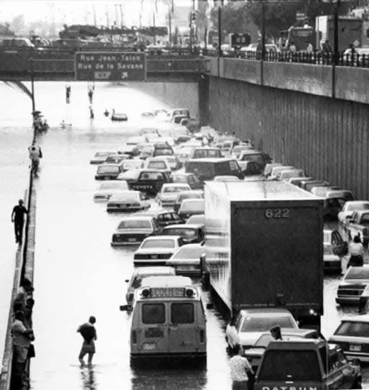
The storms come close to the July 14, 1987 anniversary of the Decarie flood. That storm officially dumped only 57.4mm of rain at Trudeau Airport, but amounts as high as 100 mm were reported in less than 1 hour in other parts of the city.

History keeps repeating it seems in Montreal. July 14 marks the 38th anniversary of the great Decarie Expressway flood.

The weather will remain very warm and humid this week, with unfortunately another risk of strong thunderstorms by Thursday. The air will also become quite unhealthy, as smoke from the western Canadian wildfires drifts into Ontario and southern Quebec. 

Wednesday, July 09, 2025

Montreal to settle into a warm and humid weather pattern

A very familiar look to the sky over Montreal this summer as the sun plays with developing cumulus clouds and thunderstorms. Montreal remains on the northern edge of a warm and humid airmass that has been delivering rounds of heat and humidity followed by strong thunderstorms. This cycle is expected to persist for the foreseeable future. (Valley Weather)

Large parts of eastern North America seem to be in a rinse and repeat cycle of warm and humid conditions, along with occasional showers and thunderstorms. This is quite typical weather for July, but what is making it different this year are the intense rain producing thunderstorms that have resulted in flash flooding in many locations.

Montreal has been fortunate to date, as most of the big wet thunderstorms have skipped the city centre. On Monday afternoon, a decent storm dumped close to 15mm on the region, producing ponding of water on highways, but little else. Trudeau Airport has measured a manageable 26mm of rain so far this month.

The balance of this week will be warm and muggy, with scattered showers and thunderstorms almost daily. High temperatures will range form the upper 20s to near 30C (80-85F), while overnight lows will be around 20C (68F). This weather pattern will continue well into next week. 

The sudden and heavy downpours make many Montrealers nervous after the deluge that flooded parts of the city last summer from Tropical Storms Beryl and Debby. The horrific images from Texas have added to the nervous emotions that exist whenever we have thunderstorms.

Most of the flash flooding we have in Montreal is caused by the inability for our sewers to handle sudden storm flows. This is very different from the circumstances that impacted the Texas Hill Country on July 4. That region has topography that is very prone to significant flash flooding, with narrow rivers channels and hilly ground. 

Heroic efforts continue from First Responders to locate victims of the horrific flash flooding that occurred in Kerr County, Texas on Friday, July 4. The death toll stands at 119 as of Wednesday morning, with 173 still missing. (Photo: Sergio Flores)

The Texas flooding is beyond catastrophic. The death toll has risen to 119 as of Wednesday morning, with another 173 missing. Intensive search, rescue and recovery efforts continue in searing heat and humidity. On July 4, between 250 and 500mm of rain fell in just a few hours, causing the Guadeloupe River to rise from a few feet to a surging 26 feet (8 metres) in less than an hour. The massive flash flood swept away homes, cottages and campers across Kerr County. The death toll includes at least 36 children.

Widespread heavy and slow moving thunderstorms have been producing flooding over many parts of the US. Major flash flooding has been observed in Texas, New Mexico, Illinois and North Carolina over the last 48 hours. Some of those wet and windy storms have crept into southwestern Ontario.

Be weather aware. As we approach the one year anniversary of the Montreal flooding, it is important to listen to daily forecasts, and especially watches or warnings that may be issued for heavy rainfall or thunderstorms. Numerous apps are available that push out weather information and warnings, including those from Environment Canada and The Weather Network.

One thing this summer is delivering across southern Quebec is plenty of heat and humidity. These weather conditions continue to fuel frequent moisture laden storms. I see no change in this pattern any time soon. Stay safe.

Monday, July 07, 2025

Thunderstorms & cooler weather for Montreal to start the week - Texas flooding

Horrific flash flooding has claimed over 80 lives in the Texas Hill Country northwest of San Antonio. Several months worth of rain fell in just a few hours Friday morning catching both holiday weekend campers and residents off guard. (Photo: Carter Johnson)

It was a tragic weather weekend in parts of Texas and the Carolinas as significant flash flooding claimed dozens of lives. The event shows just how quickly weather can turn violent, severe or even deadly. Despite the fact that weather warnings or watches often turn up empty, they cannot be ignored. Each situation is unique from the other.

On Sunday in Montreal, severe thunderstorm watches and warnings were posted for cells that turned out to be less than impressive. That happens. Summer storms form and dissipate very quickly, often in less-than an hour. While Sunday's storms were not to bad on the island of Montreal, some parts of the province did have very heavy rain, hail, power outages and wind damage.

Here in Montreal, only a few millimetres of rain fell after a steamy day. The high was 33.2C (92F), just shy of the 2010 record high of 33.6C (93F). The day was unsettled to say the least, warm and humid, a trend that is becoming all too familiar this summer across large parts of North America.

On Monday, a cold front will sag south across the St. Lawrence Valley, with significantly cooler air, along with showers and thunderstorms. Some of the storms may produce heavy rainfall. The high today will be much cooler than Sunday, reaching only 22C (72F), with brisk northeast winds. Sunshine returns Tuesday, with the high warming back up to 26C (79F). The balance of the week will remain highly variable, with temperature and humidity levels creeping back up, and a few isolated showers or thunderstorms at times.

Texas Flood Disaster

The Texas Hill Country northwest of San Antonio and specifically the Guadalupe River Valley was the scene of horrific flash flooding in the pre-dawn hours Friday morning. Several months worth of rain, between 250 and 500mm (10-20 inches) fell in just a few hours during the overnight hours. While weather warnings and updates were numerous by the National Weather Service, most residents were sleeping and caught by surprise. 

A rapidly moving wall of water swept down the Guadalupe River through Kerr County, turning the lazy river into a torrent in less than an hour. The river went from a few feet to major flood stage at over 29 feet. Flood stage is 22 feet. Residents and campers were swept away as homes and trailers were demolished. The death toll is terrible, currently at 82, including 28 children. Many of the victims were from Camp Mystic, an all girls camp on the edge of the Guadalupe. Rescuers continue to search for survivors but hope is diminishing. Resources have been pouring into the region from across Texas and the US.

The flooding occurred as an area of slow-moving thunderstorms tapped into deep Gulf of Mexico moisture producing torrential rain over the central portion of the state. Flooding in ongoing Monday morning in Texas.

Flooding is also occurring in North Carolina, as the remains of Tropical Storm Chantal move inland after making landfall along the South Carolina coast Sunday.

Thursday, July 03, 2025

Thunderstorms and muggy weather persist over southern Quebec and Ontario

Mother Nature put on a show in Laval and across the Montreal region on Canada Day, with regional fireworks displays sharing the sky with rainbows and lightning. (Photo T. Tsoukatos)

Severe Thunderstorm Watch for eastern Ontario and southern Quebec through Thursday evening.

Some storms have fired up in the muggy airmass located across southern Quebec on Thursday, but the bulk of the severe weather so far has been across northern New England. Partly cloudy skies will make the atmosphere unstable again Thursday afternoon across the region. The main threat would be gusty winds and heavy rain along with dangerous lightning.

Warm and humid air has prevailed across southern Quebec since the June 24 holiday. Temperatures have been warm, combined with elevated humidity at times. The result has been numerous showers and thunderstorms scattered across portions of Ontario and Quebec, typical summer weather.

Canada Day was extremely muggy across the region, with strong thunderstorms developing during the late afternoon and evening hours. The same was true on Wednesday evening, with thousands of lightning strikes reported between Ile Perrot and the Ontario border during the evening hours. There were reports of several homes being struck by lightning as well as power outages. Small hail was also observed.

More unsettled weather is occurring on Thursday, as a cold front slides across the region. Any thunderstorms will prevail into the early evening hours before dissipating near sunset. As winds turn out of the west, some smoke and haze may drift into southern Quebec from the western Canadian wildfires. Most of the smoke should remain in the upper atmosphere, resulting in hazy conditions.

Friday through the upcoming weekend and into Monday will feature more warm and humid weather. Friday and Saturday look dry, with highs around 27C (81F). Both temperatures and the humidity will be on the rise Sunday and Monday, closing back in on 30C (86F), with an increase risk of showers and thunderstorms from late Sunday into Monday as a frontal boundary sags southward into New York and New England.

Temperatures may cool briefly in Montreal on Monday under clouds and showers, but quickly warm back up again by Tuesday.