The misery continues
Heavy Rain Warnings for Ontario/Quebec
Heavy rain warnings have been issued for the area along the St. Lawrence River from Kingston to Quebec City. The rain from Tropical Depression Katrina should overspread our area tonight and before it ends late tomorrow about 75mm (3 inches) is expected. This rain will be accompanied by near gale force winds (80km/h) along the north shores of Lake Erie and Ontario. South of the border a Flash Flood Watch is in effect for northern New York and Vermont including St. Lawrence County.
The devastation along the Gulf Coast is terrible. The waters keep rising in New Orleans. The images are somber. I find it so sad. I always drop pretty low after a hurricane......it is so sad to see the people's lives destroyed. As a weather person you always want the storm to take an uninhabited path. It never works out that way. I don't think the Gulf Coast will be back to normal for years. The damage is so complete. My prayers are with the residents.
• If you can help www.redcross.org or www.redcross.ca
Tuesday, August 30, 2005

Monday, August 29, 2005
Damage from Katrina historic in places
What was New Orleans blessing when Katrina wobbled this morning was a curse for the Mississippi Coast. By all accounts from numerous media sources the damage has been complete in places. CNN and other sources will provide us with days of coverage on that topic.
It is sad to see the considerable damage that has been done to portions of New Orleans. However the city, which is below sea level, would have been destroyed had the small wobble not occurred. For this hurricane on the global weather picture, that wobble was not significant, storms do this, most weather systems do this. The wobble might have represented as little as 25 miles on the map, but made all the difference in the world for The Big Easy. The city will live to see another Hurricane.
Ontario: Forecasters are expecting Katrina to move along the shores of Lakes Ontario and Erie and down the St. Lawrence Valley as a depression. The potential exists for 100mm of rain over a 12 hour period. While the winds will have greatly diminished by then, as they have already, we can still expect gusts from the south and southwest close to 80km/h. Stay tuned for any warnings as the storm draws closer.
What was New Orleans blessing when Katrina wobbled this morning was a curse for the Mississippi Coast. By all accounts from numerous media sources the damage has been complete in places. CNN and other sources will provide us with days of coverage on that topic.
It is sad to see the considerable damage that has been done to portions of New Orleans. However the city, which is below sea level, would have been destroyed had the small wobble not occurred. For this hurricane on the global weather picture, that wobble was not significant, storms do this, most weather systems do this. The wobble might have represented as little as 25 miles on the map, but made all the difference in the world for The Big Easy. The city will live to see another Hurricane.
Ontario: Forecasters are expecting Katrina to move along the shores of Lakes Ontario and Erie and down the St. Lawrence Valley as a depression. The potential exists for 100mm of rain over a 12 hour period. While the winds will have greatly diminished by then, as they have already, we can still expect gusts from the south and southwest close to 80km/h. Stay tuned for any warnings as the storm draws closer.
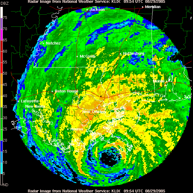
Katrina on the coast
Hurricane Katrina at 0600 EDT is on the extreme southeastern coast of Louisianna near the tiny Mississippi Delta town of Venice just east of Grand Isle. Grand Isle has reported wind gusts over 100mph.
The storm overnight took a slight, and I mean slight wobble to the east and may spare New Orleans a "direct hit". It has also sucked in some dry air along its western edge and has lost a little punch. It is now a category 4, but still an extremely dangerous storm.
The Ontario Weather Centre has issued a Special Weather Statement for heavy rain and potential flooding in our area by Wednesday.
Numerous warnings remain in effect for th Gulf Coast.
Sunday, August 28, 2005
Katrina nearing the Louisianna Coast
Hurricane Katrina, the strongest storm to threaten the US in years is about to make history. Any evacuations should be rushed to completion. The anticipated storm surge is on its way. Water on the barrier island of Grand Isle is already starting to rise over coastal roads. Winds have been gusting up to 45mph in locations along the immediate coast. The Levy system in the Parish's of coastal Louisiana is at risk.
• Katrina is the strongest storm I have followed since I began doing this in 1979. While many are comparing the storm to Camille in 1969, the storm reminds me very much of Hugo, that struck South Carolina in September 1989.
• The storm will affect Upstate New York and eastern Ontario by Wednesday with heavy rain and high winds. While it is too soon to tell how much rain will occur, over 100mm (4 inches) is not out of the question.
This site has great information for anyone looking for data on Katrina, residents and trackers alike.
http://www.disastercenter.com/Tropical%20Storm%20-%20Hurricane%20-%20Katrina.html
Hurricane Katrina, the strongest storm to threaten the US in years is about to make history. Any evacuations should be rushed to completion. The anticipated storm surge is on its way. Water on the barrier island of Grand Isle is already starting to rise over coastal roads. Winds have been gusting up to 45mph in locations along the immediate coast. The Levy system in the Parish's of coastal Louisiana is at risk.
• Katrina is the strongest storm I have followed since I began doing this in 1979. While many are comparing the storm to Camille in 1969, the storm reminds me very much of Hugo, that struck South Carolina in September 1989.
• The storm will affect Upstate New York and eastern Ontario by Wednesday with heavy rain and high winds. While it is too soon to tell how much rain will occur, over 100mm (4 inches) is not out of the question.
This site has great information for anyone looking for data on Katrina, residents and trackers alike.
http://www.disastercenter.com/Tropical%20Storm%20-%20Hurricane%20-%20Katrina.html
Katrina Stronger than Camille
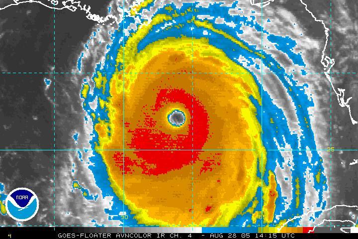
Katrina stronger than Camille
Hurricane Katrina has just reached record levels in strength. At 11:00am EDT, the National Hurricane Centre reports winds of up to 175mph with a pressure of 907mb. The only stronger Hurricane to hit this area was Camille in 1969.
Both the Mayor of New Orleans and the Gov of Louisianna have issued mandatory evacuations for New Orleans. At present traffic is jammed on Interstae 10 west out of the city. The outer bands of the storm are starting to effect coastal Jefferson Co. near Grand Isle.
The following site has extensive coverage http://www.hurricanecity.com/ stay tuned.....
Friday, August 26, 2005
Katrina a hurricane once again
Hurricane Katrina has moved back over the Gulf of Mexico just north of Key West. The strom was downgraded for only a few hours over land after pounding southern Florida overnight. Three deaths from falling trees were reported. 1.5 million people are without power. Over 10 inches of rain flooded areas from southern metro Dade towards Cutler Ridge and Homestead.
The storm is now expected to drift west before assuming a more northerly path. Projections have the storm becoming a major hurricane prior to landfall late Sunday or Monday along the Florida Panhandle.
Further ahead I expect the storm to become a major rainmaker along the entire spine of the Appalachians from Georgia to New England. This path could bring heavy rain to Eastern Ontario and Quebec. This is however at least five days out.
Hurricane Katrina has moved back over the Gulf of Mexico just north of Key West. The strom was downgraded for only a few hours over land after pounding southern Florida overnight. Three deaths from falling trees were reported. 1.5 million people are without power. Over 10 inches of rain flooded areas from southern metro Dade towards Cutler Ridge and Homestead.
The storm is now expected to drift west before assuming a more northerly path. Projections have the storm becoming a major hurricane prior to landfall late Sunday or Monday along the Florida Panhandle.
Further ahead I expect the storm to become a major rainmaker along the entire spine of the Appalachians from Georgia to New England. This path could bring heavy rain to Eastern Ontario and Quebec. This is however at least five days out.
Thursday, August 25, 2005
Katrina moves inland...
The storm that has become a killer in a very short time is now inland over south Florida. The storm made landfall during the supper hour along the Broward County line with Dade County. The storm then took and unexpected wobble to the south and is pounding metro Dade and the southern suburbs. Two deaths have been reported thus far with more than a half million customers without power in the state. A wind gust at Port Everglades was reported at 92 mph. Forecasters expect the slow moving hurricane to dump upwards of a foot or rain on the state before moving over the warm Gulf waters. Katrina will then take aim at the hurricane weary state once again with a second hit in the Panhandle near Apalachicola. It is too soon to tell exactly where or how strong she may become once moving back over water. Updates can be found at the National Hurricane Centre website.
The storm may play a role in Canadian (Ontario to the Maratimes) weather next week. That is way in the future...Stay tuned.
This hurricane season has a lot more to show us before it ends.......
Those of you who know me please comment on the blog and tell me what you would like to see. Drop me an email at home or work... thanks.
The storm that has become a killer in a very short time is now inland over south Florida. The storm made landfall during the supper hour along the Broward County line with Dade County. The storm then took and unexpected wobble to the south and is pounding metro Dade and the southern suburbs. Two deaths have been reported thus far with more than a half million customers without power in the state. A wind gust at Port Everglades was reported at 92 mph. Forecasters expect the slow moving hurricane to dump upwards of a foot or rain on the state before moving over the warm Gulf waters. Katrina will then take aim at the hurricane weary state once again with a second hit in the Panhandle near Apalachicola. It is too soon to tell exactly where or how strong she may become once moving back over water. Updates can be found at the National Hurricane Centre website.
The storm may play a role in Canadian (Ontario to the Maratimes) weather next week. That is way in the future...Stay tuned.
This hurricane season has a lot more to show us before it ends.......
Those of you who know me please comment on the blog and tell me what you would like to see. Drop me an email at home
 or work... thanks.
Tuesday, August 16, 2005
Dense fog makes travel difficult
Heavy thick fog developed yesterday creating a dangerous travel situation for a few hours on area highways. Visibility on rural roads especially, was less than a kilometer in many cases. The fog formed after a brief rainfall Sunday and cooler overnight temperatures than we have seen in some time. With the longer nights, the air temperatures are cooling. Some trees are even beginning to show signs of color.
Below: The sun through fog on Highway 401 near Lancaster

Wednesday, August 03, 2005
Hot & Humid again....
• The intense heat and humidity are back through the balance of this week. Environment Canada has issued a Smog Advisory along with a Humidex Advisory. The combination of warm temperatures and humidity will push values over 40C today and tomorrow. A cold front will move through the area Friday with more widespread storms and showers. The air will dry out this weekend, but it will remain warm near 29C.
Right bottom: Storms move south of Kemptville last night.....
• Yesterday's near fatal crash of and Air France AirBus at Pearson Airport in Toronto was a direct result of the weather according to experts. At the time a very narrow band of heavy thunderstorms stretched from Georgian Bay south to Lake Ontario. The rain was intense along with frequent lightning and low visibility. Thunderstorms produce up and downdrafts at various speeds and directions that make it very dangerous to fly near. Most pilots avoid t hem all together. Thank God all the safety workers and Air France Crew did such a miraculous job. My hats off to them....
• Lastly the eighth storm of the Atlantic Hurricane season has formed near Bermuda. Tropical Storm Harvey is expected to produce heavy rain on the tiny island before moving off to the north and east. It may affect the Grand Banks like Franklin did, but it is too soon to say. Harvey is the 8th storm as I said, which makes it the earliest formed eight storm since record keeping began in the 1800's. The average, believe it or not, is September 29. Be safe!
• The intense heat and humidity are back through the balance of this week. Environment Canada has issued a Smog Advisory along with a Humidex Advisory. The combination of warm temperatures and humidity will push values over 40C today and tomorrow. A cold front will move through the area Friday with more widespread storms and showers. The air will dry out this weekend, but it will remain warm near 29C.
Right bottom: Storms move south of Kemptville last night.....
• Yesterday's near fatal crash of and Air France AirBus at Pearson Airport in Toronto was a direct result of the weather according to experts. At the time a very narrow band of heavy thunderstorms stretched from Georgian Bay south to Lake Ontario. The rain was intense along with frequent lightning and low visibility. Thunderstorms produce up and downdrafts at various speeds and directions that make it very dangerous to fly near. Most pilots avoid t
 hem all together. Thank God all the safety workers and Air France Crew did such a miraculous job. My hats off to them....
• Lastly the eighth storm of the Atlantic Hurricane season has formed near Bermuda. Tropical Storm Harvey is expected to produce heavy rain on the tiny island before moving off to the north and east. It may affect the Grand Banks like Franklin did, but it is too soon to say. Harvey is the 8th storm as I said, which makes it the earliest formed eight storm since record keeping began in the 1800's. The average, believe it or not, is September 29. Be safe!
Monday, July 25, 2005
More thunderstorms then a little cooler this week
It has been a very hot summer in eastern Canada. This weekend was no different with high temperatures close to 29C. Today will be warm and humid again, with a high near 31C. Some thunderstorm activity is expected along a cold front on Tuesday before splendid weather moves in for the balance of the week. Temperatures will be in the 24-27C range with low humidity and clear cool nights. Should be great mid-summer weather.
Over the weekend most of the severe weather was confined to Friday afternoon in southwest Quebec. Very heavy thunderstorms produced straight line winds that tumbled a whole bunch of trees and power lines in Mascouche, north of Montreal. In addition heavy rain fe ll from Valleyfield to the Ontario border with 43mm in less than an hour in St. Anicet, on the St. Lawrence River.
Over the weekend Tropical Strom Franklin wandered the Atlantic waters west of Bermuda, while tropical Strom Gert moved inland near Tampico, Mexico. Both storms are expected to be mostly rain makers and little threat to life or property. Amazing! 7 named storms and it is not even August...What a season!
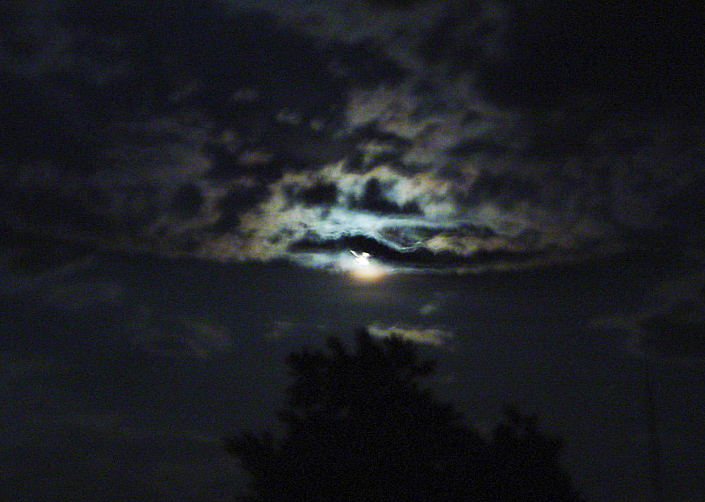
The picture on above-right is last weeks full moon in Kemptville through distant thunderstorms......
It has been a very hot summer in eastern Canada. This weekend was no different with high temperatures close to 29C. Today will be warm and humid again, with a high near 31C. Some thunderstorm activity is expected along a cold front on Tuesday before splendid weather moves in for the balance of the week. Temperatures will be in the 24-27C range with low humidity and clear cool nights. Should be great mid-summer weather.
Over the weekend most of the severe weather was confined to Friday afternoon in southwest Quebec. Very heavy thunderstorms produced straight line winds that tumbled a whole bunch of trees and power lines in Mascouche, north of Montreal. In addition heavy rain fe
 ll from Valleyfield to the Ontario border with 43mm in less than an hour in St. Anicet, on the St. Lawrence River.
Over the weekend Tropical Strom Franklin wandered the Atlantic waters west of Bermuda, while tropical Strom Gert moved inland near Tampico, Mexico. Both storms are expected to be mostly rain makers and little threat to life or property. Amazing! 7 named storms and it is not even August...What a season!
The picture on above-right is last weeks full moon in Kemptville through distant thunderstorms......
Tuesday, July 19, 2005

Humidity lowering across North Grenville
A brief respite is in order for heat weary residents in Ontario and Quebec. Temperatures and humidity have been almost unbearable. The combination of warm temperatures and humidity values in the 70 per cent range had humidex values well over 40C yesterday and today. With that type of heat the dewpoints were in the Key West, Florida range!! Very tropical indeed. A weak cold front passage will begin to dry out the air slowly. Temperatures however will remain quite warm. The high tomorrow and Thursday will be around 30C while Friday should be a touch cooler with showers and thunderstorms, around 26C.
Hurricane Emily swept over the resort towns of Cancun and Cozumel and is now heading for the Texas/Mexican border. A hurricane warning is in effect for the south Texas coast. Tropical Storm force winds and high tides have begun and will continue to increase as the evening wears on. Brownsville is in the centre of the target cone for Emily.
Friday, July 15, 2005
Slept well....Finally
A slight drop in humidity and a lowering of dewpoints allowed for a more comfortable sleeping pattern last night. Temperatures will reach around 30C today, but it should feel just a touch better in Ottawa and Montreal. In addition to the lower temperature last night it was quiet. For the first time in three nights thunderstorms did not develop in Kemptville.
The forecast is calling for a return to hot humid and unsettled weather over the weekend. What is left of Dennis will drift across New England on the weekend providing enough lift for some tropical rains. They will be hit and miss thunderstorms in the humid air.
Just a note on lightning safety. It is one of the leading killers in a thunderstorm. Keep in mind that lightning can strike 30 minutes on either side of your storm. Be safe all the time. The best course of action is to remain indoors or in your car. People underestimate just how dangerours it is.
Emily has become a Category four and is threatening Jamaica the Cayman Islands and then Cozumel and Cancun. Afterwards suggestions now indicate she may head for the mouth of the Rio Grande River on the Texas/Mexican border....Many days off stay tuned!
A slight drop in humidity and a lowering of dewpoints allowed for a more comfortable sleeping pattern last night. Temperatures will reach around 30C today, but it should feel just a touch better in Ottawa and Montreal. In addition to the lower temperature last night it was quiet. For the first time in three nights thunderstorms did not develop in Kemptville.
The forecast is calling for a return to hot humid and unsettled weather over the weekend. What is left of Dennis will drift across New England on the weekend providing enough lift for some tropical rains. They will be hit and miss thunderstorms in the humid air.
Just a note on lightning safety. It is one of the leading killers in a thunderstorm. Keep in mind that lightning can strike 30 minutes on either side of your storm. Be safe all the time. The best course of action is to remain indoors or in your car. People underestimate just how dangerours it is.
Emily has become a Category four and is threatening Jamaica the Cayman Islands and then Cozumel and Cancun. Afterwards suggestions now indicate she may head for the mouth of the Rio Grande River on the Texas/Mexican border....Many days off stay tuned!
Thursday, July 14, 2005
Another Round of Severe Weather
More strong thunderstorms rumbled across the Ottawa and St. Lawrence Valley area overnight. The strongest of the storms moved through Ottawa around 9pm last night. Power outages were reported along with downed trees across the border in Gatineau. One 40 year old man was struck by lightning at Kanata Centrum. He is in serious condition.
When the storms approached the Kemptville area the lightning display was spectacular. At times the sky resembled mid-day. The Kemptville Fire Department was called out to at least one lightning strike east of town. Power was disrupted both in Ottawa and for a very short time in North Grenville. Over 35mm of rain fell with these storms in Kemptville. Temperatures today are just a touch cooler. Thunderstorms are developing this afternoon in a line north of Kingston. Tomorrow dewpoints will lower slightly making it a more comfortable day in Ottawa and Montreal, but more heat and humidity is on the way for the weekend and well into next week.
In tropical news, Emily has passed over the tiny island of Grenada and is moving towards the Yucatan, Mexico. She is now a Category 2 Storm. On this projected path, she may bypass the US all together. These storms are very fickle, and the slightest wobble could change that.
More strong thunderstorms rumbled across the Ottawa and St. Lawrence Valley area overnight. The strongest of the storms moved through Ottawa around 9pm last night. Power outages were reported along with downed trees across the border in Gatineau. One 40 year old man was struck by lightning at Kanata Centrum. He is in serious condition.
When the storms approached the Kemptville area the lightning display was spectacular. At times the sky resembled mid-day. The Kemptville Fire Department was called out to at least one lightning strike east of town. Power was disrupted both in Ottawa and for a very short time in North Grenville. Over 35mm of rain fell with these storms in Kemptville. Temperatures today are just a touch cooler. Thunderstorms are developing this afternoon in a line north of Kingston. Tomorrow dewpoints will lower slightly making it a more comfortable day in Ottawa and Montreal, but more heat and humidity is on the way for the weekend and well into next week.
In tropical news, Emily has passed over the tiny island of Grenada and is moving towards the Yucatan, Mexico. She is now a Category 2 Storm. On this projected path, she may bypass the US all together. These storms are very fickle, and the slightest wobble could change that.
Wednesday, July 13, 2005
Thunderstorms break the Heat...A little
Heavy thunderstorms broke the heat across Eastern Ontario overnight. These rare nocturnal storms produced brief heavy rains. The most interesting aspect of the storms which began shortly after midnight and continued until around noon today, on and off, was the intense cloud to ground lightning and their duration. The strikes played havoc with electrical equipment but no major outages seem to have occurred.
The cloud cover and brief rain has kept the temperatures down today in the mid 20's but they are beginning to warm up as the clouds have cleared this afternoon. We remain under a Severe Thunderstorm Warning across Grenville County and area. More storms should flare up in the tropical airmass this afternoon. The photo below shows a dissipating storms to the east of Kemptville this morning.
The cloud cover and brief rain has kept the temperatures down today in the mid 20's but they are beginning to warm up as the clouds have cleared this afternoon. We remain under a Severe Thunderstorm Warning across Grenville County and area. More storms should flare up in the tropical airmass this afternoon. The photo below shows a dissipating storms to the east of Kemptville this morning.

Subscribe to:
Posts (Atom)