Flooding Spreads West
Build your Ark. No joking, the flooding rains that have been occurring in eastern New England are spreading west. Another stubborn low pressure area will move up the Atlantic Coast today spreading heavy rain, 25-50mm with embedded thunderstorms into Eastern Ontario and Northern NY. A Flood Watch is posted in the US. Some areas in Ontario...in our area, have had close to 2 inches of rain in the last week, 7 straight days or rain and showers!. The ground is still accepting the water, but area waterways are filling and water speeds are increasing. Keep this in mind this Holiday weekend if you plan on being in or on the water. The weekend will be a washout in Ontario and Quebec. Sorry to say.
Our first thunderstorms of the season spread north across North Grenville last night with lightning and 15mm of rain. All area parks in the City of Ottawa are closed until further notice because of the soggy ground.
Friday, May 19, 2006

Wednesday, May 17, 2006
Will the rain ever end?
Heavy rain continues to fall around a deep upper level low over the Great Lakes. The storm has persisted over the area since last Thursday. Since Thursday, North Grenville has had over 35mm of rain. While this seems impressive, portions of the Merrimack River Valley in New Hampshire and Mass have reported over 300mm (12 inches). The heavy rain has resulted in the worst flooding in New England in close to 70 years, since the Hurricane of 1938. One death has occured. Damage is in the millions. While the rain has lightened in New England, heavy showers and thunderstorms continue to spin around the low over Quebec and Ontario. A severe thunderstorm watch is in effect for southwestern Ontario this afternoon. No relief is expected into the weekend.
Heavy Rain in Kemptville
- Tuesday night.

Heavy rain continues to fall around a deep upper level low over the Great Lakes. The storm has persisted over the area since last Thursday. Since Thursday, North Grenville has had over 35mm of rain. While this seems impressive, portions of the Merrimack River Valley in New Hampshire and Mass have reported over 300mm (12 inches). The heavy rain has resulted in the worst flooding in New England in close to 70 years, since the Hurricane of 1938. One death has occured. Damage is in the millions. While the rain has lightened in New England, heavy showers and thunderstorms continue to spin around the low over Quebec and Ontario. A severe thunderstorm watch is in effect for southwestern Ontario this afternoon. No relief is expected into the weekend.
Heavy Rain in Kemptville
- Tuesday night.
Thursday, May 11, 2006
Heavy Rain for Ontario....
A stubborn upper level low will rotate throughout the Great Lakes this weekend - very slowly. As a result a cold rain with embedded thunderstorms will dump 30-50mm of rain from Windsor to Montreal through Saturday. Gusty southwest winds will reach speeds of 60km/h near the Great Lakes. It will be nasty and cool along much of the eastern coastline. Further south heavy thunderstorms will stretch from Texas to the Carolinas.
http://www.weatheroffice.ec.gc.ca/warnings/SWS_bulletins_e.html?prov=on
A stubborn upper level low will rotate throughout the Great Lakes this weekend - very slowly. As a result a cold rain with embedded thunderstorms will dump 30-50mm of rain from Windsor to Montreal through Saturday. Gusty southwest winds will reach speeds of 60km/h near the Great Lakes. It will be nasty and cool along much of the eastern coastline. Further south heavy thunderstorms will stretch from Texas to the Carolinas.
http://www.weatheroffice.ec.gc.ca/warnings/SWS_bulletins_e.html?prov=on
Tuesday, April 18, 2006
Winter Weather in parts of
Saskatchewan and the Dakotas
While the east continues to enjoy what has amounted to a very early spring, (it is currently 19C in Kemptville), the west is dealing with a potent late winter storm. The system is currently in Montana sliding eastwards. It has a wide area of very heavy precipitation, that for the most part is falling as rain. However areas along the Manitoba/Saskatchewan border south of the Trans Canada and along the Montana/Dakotas border are expecting heavy wet snow. Blizzard Warnings are in effect in eastern Montana while a general Weather Warning is in effect for Southeast Saskatchewan. 100km/h winds could accompany the precipitation.

The heavy rain in the Dakotas is expected to only add to the flooding misery in the Red River Valley of North Dakota and Manitoba. The picture above shows Interstate 29 just south of Pembina and the Manitoba border.
In the east warm dry weather has lead to the issuance of a Fire Weather Watch for upstate NY. Low relative humidities combined with dry warm southwest winds may lead to a serious grass fire threat. Last week several fires were reported again in Leeds and Grenville. Be very attentive to any outdoor burning.
Saskatchewan and the Dakotas
While the east continues to enjoy what has amounted to a very early spring, (it is currently 19C in Kemptville), the west is dealing with a potent late winter storm. The system is currently in Montana sliding eastwards. It has a wide area of very heavy precipitation, that for the most part is falling as rain. However areas along the Manitoba/Saskatchewan border south of the Trans Canada and along the Montana/Dakotas border are expecting heavy wet snow. Blizzard Warnings are in effect in eastern Montana while a general Weather Warning is in effect for Southeast Saskatchewan. 100km/h winds could accompany the precipitation.

The heavy rain in the Dakotas is expected to only add to the flooding misery in the Red River Valley of North Dakota and Manitoba. The picture above shows Interstate 29 just south of Pembina and the Manitoba border.
In the east warm dry weather has lead to the issuance of a Fire Weather Watch for upstate NY. Low relative humidities combined with dry warm southwest winds may lead to a serious grass fire threat. Last week several fires were reported again in Leeds and Grenville. Be very attentive to any outdoor burning.
Thursday, April 13, 2006
Eastern Ontario/Western Quebec
Severe Weather Outlook
This is the first of what I hope will be daily updates regarding the risk of severe thunderstorms within our area. Time and life aside, I will post these every morning and update them when severe weather is expected. Also updated US warnings and discussions are available at this link: http://www.spc.noaa.gov/products/outlook/day1otlk.html
Today: There is a slight risk of convective thunderstorm activity around Western New York and southwest Ontario close to Lake Erie from Hamilton to Windsor. In Eastern Ontario gusty winds to 50km/h and a few sprinkles are expected with perhaps a rumble of thunder.
Severe Weather Outlook
This is the first of what I hope will be daily updates regarding the risk of severe thunderstorms within our area. Time and life aside, I will post these every morning and update them when severe weather is expected. Also updated US warnings and discussions are available at this link: http://www.spc.noaa.gov/products/outlook/day1otlk.html
Today: There is a slight risk of convective thunderstorm activity around Western New York and southwest Ontario close to Lake Erie from Hamilton to Windsor. In Eastern Ontario gusty winds to 50km/h and a few sprinkles are expected with perhaps a rumble of thunder.
Monday, April 03, 2006
Thoughts on the warm weather
Snow expected tomorrow!
Greetings weatherverts, so sorry for the lack of writing these days. A couple of factors have played into this. Number 1, March was a very quiet month for weather in Ontario. The second factor is work has been unreal so the thought of more time in front of the computer has not been very appealing.
Nevertheless weather has been happening, as it always does. The Midwest US, the Southern Plains and southeast States have had a an unusually early start to severe weather season. I guess that is to match the late finish. Not much of a break. 27 people died yesterday alone.
It has been very warm of late in Ontario and Quebec. Last Friday we saw several record highs smashed in both provinces including Montreal, Ottawa and Kemptville. It was 24C in Kemptville making it one of the warmest places in the country. This was 76F folks on March 31! People were wearing shorts and hanging their arms out car windows. Restaurant terraces were filled. There is no snow left in Kmeptville. Unfortunately with the warm windy weather has come the threat of grass fires. Several have been reported in the Grenville County with numerous more across Ontario. The fire threat remains elevated across Ontario, New York and Vermont.
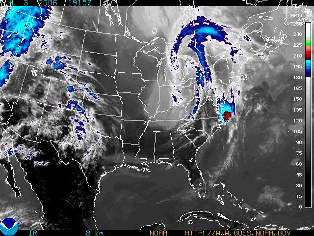
All good things must come to an end. Low pressure moving through Ontario today will spawn a second storm near Delmarva tonight. (See the red along the east coast above) This system will move north with moisture and at the same time colder air will sink south into upstate NY and New England. Tonight's rain will change to snow over higher elevations with 6 inches possible by Thursday. Along the valleys just a few flurries are expected at this time. It will however be windy and about 40 degrees F colder than last Friday! Stay tuned!
Monday, March 13, 2006
Winter and Spring battle
The seasons are hosting a battle with us stuck in between. Severe Weather over the weekend claimed at least five lives across the Midwest US with tornadoes from Texas to Illinois. This morning severe thunderstorms are expected as far north as Windsor and London.
A strong Colorado Low over Iowa is moving northeast towards Ontario. As the system spreads east so will a wide variety of spring and winter weather. Dense fog has developed in the Ottawa and St. Lawrence Valley's, that will quickly be replaced by heavy rain and thunderstorms as the day moves on. So for Ottawa and Montreal as well as the Seaway area, today will feature heavy rain, close to 40mm total. This will be followed by a spike in temperatures this evening up to around 12C. Overnight the cold front will approach. Strong Thunderstorms are possible along the front. Tomorrow, strong winds up to 60km/h along with dropping temperatures to below freezing and scattered snowshowers. So it will be a typical roller coaster weather event.
Weather Warnings...
Freezing Rain Warning: Upper Ottawa Valley
Severe Thunderstorm Warning: Southwest Ontario Windsor to London (may be extended east)
Dense Fog Advisory: St. Lawrence County NY
Heavy Rain Warning: Montreal south to US Border & Eastern Townships
Winter Strom Warning: Northeast Ontario
The seasons are hosting a battle with us stuck in between. Severe Weather over the weekend claimed at least five lives across the Midwest US with tornadoes from Texas to Illinois. This morning severe thunderstorms are expected as far north as Windsor and London.
A strong Colorado Low over Iowa is moving northeast towards Ontario. As the system spreads east so will a wide variety of spring and winter weather. Dense fog has developed in the Ottawa and St. Lawrence Valley's, that will quickly be replaced by heavy rain and thunderstorms as the day moves on. So for Ottawa and Montreal as well as the Seaway area, today will feature heavy rain, close to 40mm total. This will be followed by a spike in temperatures this evening up to around 12C. Overnight the cold front will approach. Strong Thunderstorms are possible along the front. Tomorrow, strong winds up to 60km/h along with dropping temperatures to below freezing and scattered snowshowers. So it will be a typical roller coaster weather event.
Weather Warnings...
Freezing Rain Warning: Upper Ottawa Valley
Severe Thunderstorm Warning: Southwest Ontario Windsor to London (may be extended east)
Dense Fog Advisory: St. Lawrence County NY
Heavy Rain Warning: Montreal south to US Border & Eastern Townships
Winter Strom Warning: Northeast Ontario
Saturday, March 04, 2006
More SNOW for Saskatchewan
What was to this point a fairly mild winter across the west is quickly becoming a cold spring. More snow and blowing snow is moving into the southwest part of the province and across Montana and North Dakota. The snow and wind will prevail for most of the day today and into tonight. A general snowfall of 10-15cm is expected with winds gusting over 50km/h. Travel will be poor on area highways.
A Winter Storm Warning is in effect for the areas north of the Number 1 up to the Yellowhead, with a Winter Weather Advisory for Northeast Montana.
What was to this point a fairly mild winter across the west is quickly becoming a cold spring. More snow and blowing snow is moving into the southwest part of the province and across Montana and North Dakota. The snow and wind will prevail for most of the day today and into tonight. A general snowfall of 10-15cm is expected with winds gusting over 50km/h. Travel will be poor on area highways.
A Winter Storm Warning is in effect for the areas north of the Number 1 up to the Yellowhead, with a Winter Weather Advisory for Northeast Montana.
Friday, February 24, 2006
Clipper system heads for Ontario
This mornings gusty winds and snow were a little bit of a surprise for me. Winds in the 30-50km/h range will slowly diminish today as high pressure briefly moves into the area. They are causing poor visibility along the 417.
The next storm is right on its heels moving into the province tomorrow before sliding south of Lake Ontario. The storm is a strong clipper and will give between 10-20cm to most of the province starting tonight and most of Saturday. Snowfall Warnings are in place from Renfrew south to Kingston and west to London. As the system passes to our south and east winds will pick up from 30-50km/h causing blowing snow again. Travel will be poor on Saturday in the 401/417/416 corridor and south along I-87 and 81.
This mornings gusty winds and snow were a little bit of a surprise for me. Winds in the 30-50km/h range will slowly diminish today as high pressure briefly moves into the area. They are causing poor visibility along the 417.
The next storm is right on its heels moving into the province tomorrow before sliding south of Lake Ontario. The storm is a strong clipper and will give between 10-20cm to most of the province starting tonight and most of Saturday. Snowfall Warnings are in place from Renfrew south to Kingston and west to London. As the system passes to our south and east winds will pick up from 30-50km/h causing blowing snow again. Travel will be poor on Saturday in the 401/417/416 corridor and south along I-87 and 81.
Friday, February 17, 2006
 Squalls in Kemptville today ValleyWX Photo
 Strom wreaks havoc in area
The rapid freeze was historic across our area today. The temperature in Kemptville fell from 6C to -6C in less than one hour. The result was a rapid freeze that has left roads very dangerous. It is currently -12C with winds of 50km/h and a windchill of -22C. This was one of the most rapid drop in temperatures I have ever recorded.
Winds have gusted up to and over 100km/h in areas including 111km/h at Dorval, QC.
Power is out according to Hydro One and Hydro Ottawa to thousands of homes and businesses in the area.
The worst fact has been the roads. Two multiple car accidents have closed the 417 east and west of Ottawa. The crash east of Ottawa is at exit 88 involving 30 cars and according to OPP has resulted in 3 deaths.
They are reminding drivers to slow down or not travel at all.
High Wind Warnings remain in effect for the Seaway Valley.
Warnings are many east to west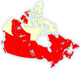
Winter returns to Canada
From ice and snow in the east to arctic chill and high windchills in the Prairies, winter has returned. I spent the first hour of my day trying to scrape the large amount of ice off my wind gauges and reset my frozen thermometres. I will post some pictures when the sun comes up and I can get out. It is bad out there we have had lots of ice in the Rideau and Ottawa Valley's and it contiues to fall. it will only get worse as the temperature drops. trees, power lines and roads are coated.
It is currently near 0C (32F) in Kemptville. We have had heavy rain and freezing rain most of the night to go with the 10cm of snow that fell yesterday. A strong arctic cold front is just to our west. It should roar through the area today. The temperatures will nudge above freezing for a fleeting moment or two this morning, before plunging down to -6C by noon. A flash freeze is likely and winds will pick up from the west and northwest at 60-90km/h across all areas but especially along the St. Lawrence River and 401 corridor. (50-60MPH in New York State)
Things will settle down tonight. Of note, some snow may fall along the front and it could be near zero visibility briefly in any snow.
Expect icy roads and sidewalks today........be safe!
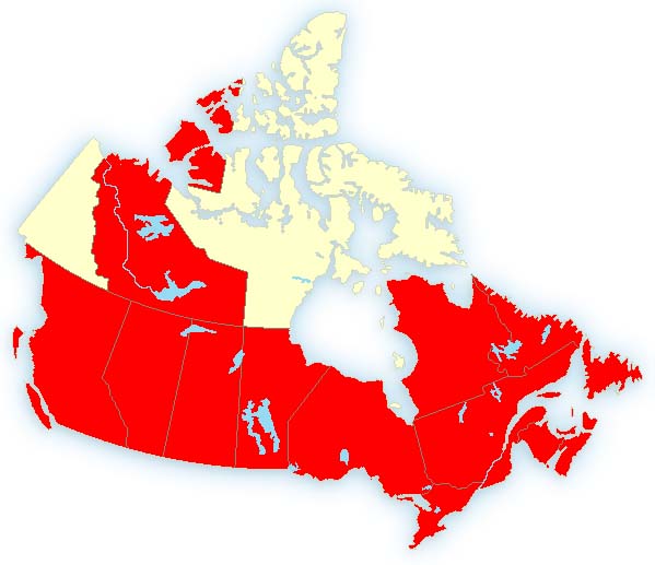
Freezing Rain Warning: Montreal/Ottawa
High Wind Warning: Montreal/Upstate New York
Flash freeze Warning: All Areas.....
Winter returns to Canada
From ice and snow in the east to arctic chill and high windchills in the Prairies, winter has returned. I spent the first hour of my day trying to scrape the large amount of ice off my wind gauges and reset my frozen thermometres. I will post some pictures when the sun comes up and I can get out. It is bad out there we have had lots of ice in the Rideau and Ottawa Valley's and it contiues to fall. it will only get worse as the temperature drops. trees, power lines and roads are coated.
It is currently near 0C (32F) in Kemptville. We have had heavy rain and freezing rain most of the night to go with the 10cm of snow that fell yesterday. A strong arctic cold front is just to our west. It should roar through the area today. The temperatures will nudge above freezing for a fleeting moment or two this morning, before plunging down to -6C by noon. A flash freeze is likely and winds will pick up from the west and northwest at 60-90km/h across all areas but especially along the St. Lawrence River and 401 corridor. (50-60MPH in New York State)
Things will settle down tonight. Of note, some snow may fall along the front and it could be near zero visibility briefly in any snow.
Expect icy roads and sidewalks today........be safe!
Freezing Rain Warning: Montreal/Ottawa
High Wind Warning: Montreal/Upstate New York
Flash freeze Warning: All Areas.....
Thursday, February 16, 2006
Winter returns.....
A strong winter storm backed by an Arctic boundary is pressing into the St. Lawrence Valley this morning. Snow will begin shortly and spread into Montreal. Up to 10cm of snow may fall before the precipitation changes over to freezing rain. The freezing rain will last for up to 6 hours in Ottawa an Montreal.
A Freezing Rain Warning is in effect for all of Eastern Ontario and Western Quebec.
A Winter Weather Advisory is in effect for St. Lawrence County in New York.
Behind the storm High Winds - with gust up to 100km/h are possible along the Great Lakes and down the St. Lawrence Valley. High Wind Watches have been posted. These will likely be upgraded later today.
Temperatures: They are around -5C now in Kemptville, will slowly rise to above freezing overnight tonight and then plummet Friday to -18C by Friday night.
Out West: Windchill Warnings are in effect across all three Prairie provinces as winds and bitter cold drop readings into the -40C range, the coldest this season.
A strong winter storm backed by an Arctic boundary is pressing into the St. Lawrence Valley this morning. Snow will begin shortly and spread into Montreal. Up to 10cm of snow may fall before the precipitation changes over to freezing rain. The freezing rain will last for up to 6 hours in Ottawa an Montreal.
A Freezing Rain Warning is in effect for all of Eastern Ontario and Western Quebec.
A Winter Weather Advisory is in effect for St. Lawrence County in New York.
Behind the storm High Winds - with gust up to 100km/h are possible along the Great Lakes and down the St. Lawrence Valley. High Wind Watches have been posted. These will likely be upgraded later today.
Temperatures: They are around -5C now in Kemptville, will slowly rise to above freezing overnight tonight and then plummet Friday to -18C by Friday night.
Out West: Windchill Warnings are in effect across all three Prairie provinces as winds and bitter cold drop readings into the -40C range, the coldest this season.
Tuesday, February 14, 2006
Possible storm by Thursday
in Ontario and Quebec
This is a heads up to people living in Ontario and Quebec. A developing Colorado low south of the Great Lakes is expected to move south of the St. Lawrence Valley on Friday. At this time it appears snow and freezing rain will overspread the area from southwest to northeast on Thursday, followed by strong winds and arctic cold on Friday. It is still early but a Special Weather Statement has been issued by both the US and Canadian offices.
in Ontario and Quebec
This is a heads up to people living in Ontario and Quebec. A developing Colorado low south of the Great Lakes is expected to move south of the St. Lawrence Valley on Friday. At this time it appears snow and freezing rain will overspread the area from southwest to northeast on Thursday, followed by strong winds and arctic cold on Friday. It is still early but a Special Weather Statement has been issued by both the US and Canadian offices.
Monday, February 13, 2006
 Hanlin wins yesterday's Gatorade Duel
 Big storm along the East Coast
Five days till Daytona 500.....
Sorry for the lack of entries over the past few weeks. It is that time of year where numerous distractions come my way. After Groundhog Day and between Christmas and Easter, we are in a nasty stretch that all too many Canadians no about. Even if we have had a relatively easy winter in parts, it is still winter. It has been dark, damp and dirty. The three D's as I like to call them. I can't keep my car clean for five minutes. And there are no long weekends to help us out.
Then along comes my other big interest, NASCAR to brighten the weekends up a little. I have been a fan for "pert near" 20 years. Love the sport and we are five days till Daytona.
I would be a miss if I did not mention the record storm along the east coast. It closed most airports between Philly and Maine yesterday and continues to smack the Maratimes this morning. For the most part 1-2 feet of snow fell with a whopping 26.2 inches in central Park, a new record. There have been worse storms, the Superstorm of March 1993 comes to mind, but the US media wants to play this one up, so we will say it was the deepest for now, but the 93 storm sliced into all forms of travel for days. Nevertheless it was a bad storm and I am jealous that all we received in southern Quebec and Ontario was gusty northeast winds and the northern cloud deck from the system.
The lake effect machine is on again. Snow Advisories are posted for Lewis and Jefferson Counties in New York, just south of Gannanoque. This same area received over 2 feet just last week.
Saturday, February 04, 2006
Nasty Winter Storm for Ontario
A big winter storm over the southern Appalachians is forecast to move north towards Lake Erie while deepening. The storm is expected to cut the forecast area in two traveling north towards Pembroke. West and north of the storm heavy wet snow is expected. Amounts will be in the 20-30cm range. East and south of the track heavy rain is expected from Oshawa east towards Cornwall. Here from 20-50mm of rain may fall. There is a potential for minor flooding along water ways. In all areas as the low pressure continues to deepen, winds will increase to between 40-60km/h with even higher gusts on Sunday. As the storm pulls to the north, cold air will flood into the area Sunday turning all rain to snow and blowing snow. Roads in the province will become icy and visibility will be limited. The same holds true for western New York and southeast Michigan where from 6-12 inches of snow may fall. The track may vary slightly which would make a big difference in precipitation type so stay tuned.
Winter Storm Warning: Ottawa Valley, Southern Ontario, Western New York, Michigan
Heavy Rain Warning: St. Lawrence Valley
Blowing Snow Advisory: Upper Ottawa Valley in Quebec
Heavy Snow Warning: Northern Laurentians in Quebec
A big winter storm over the southern Appalachians is forecast to move north towards Lake Erie while deepening. The storm is expected to cut the forecast area in two traveling north towards Pembroke. West and north of the storm heavy wet snow is expected. Amounts will be in the 20-30cm range. East and south of the track heavy rain is expected from Oshawa east towards Cornwall. Here from 20-50mm of rain may fall. There is a potential for minor flooding along water ways. In all areas as the low pressure continues to deepen, winds will increase to between 40-60km/h with even higher gusts on Sunday. As the storm pulls to the north, cold air will flood into the area Sunday turning all rain to snow and blowing snow. Roads in the province will become icy and visibility will be limited. The same holds true for western New York and southeast Michigan where from 6-12 inches of snow may fall. The track may vary slightly which would make a big difference in precipitation type so stay tuned.
Winter Storm Warning: Ottawa Valley, Southern Ontario, Western New York, Michigan
Heavy Rain Warning: St. Lawrence Valley
Blowing Snow Advisory: Upper Ottawa Valley in Quebec
Heavy Snow Warning: Northern Laurentians in Quebec
Friday, February 03, 2006
Winter Strom Watch........Again
Yet another mild period in Ontario & Quebec. Yet another Winter Storm Watch for the potential of a big storm late Saturday into Sunday and yet again a difficult forecast. Environment Canada has Posted a Winter Storm Watch for all the counties of southern Ontario from the Quebec border to Windsor.
A very strong 976mb storm is expected to develop and move north from Mississippi to Lake Erie by late Saturday. East of the storm track up to 40mm of rain is expected while west of the storm track 25cm of heavy wet snow. The Winter Storm watches are also in effect for New York State, Ohio, Pennsylvania and Southeast Michigan including Detroit where this weekends Super Bowl is scheduled at Ford Field.
Behind the storm for all areas Heavy Wet Snow and gusty winds over 50km/h will occur Sunday. The potential exists for heavy precipitation and damaging winds this weekend. Plan accordingly if you expect to travel anywhere in the 401 corridor or south along I-81, I-80, and I-87.
Next Update will be at 8am Saturday.....
Yet another mild period in Ontario & Quebec. Yet another Winter Storm Watch for the potential of a big storm late Saturday into Sunday and yet again a difficult forecast. Environment Canada has Posted a Winter Storm Watch for all the counties of southern Ontario from the Quebec border to Windsor.
A very strong 976mb storm is expected to develop and move north from Mississippi to Lake Erie by late Saturday. East of the storm track up to 40mm of rain is expected while west of the storm track 25cm of heavy wet snow. The Winter Storm watches are also in effect for New York State, Ohio, Pennsylvania and Southeast Michigan including Detroit where this weekends Super Bowl is scheduled at Ford Field.
Behind the storm for all areas Heavy Wet Snow and gusty winds over 50km/h will occur Sunday. The potential exists for heavy precipitation and damaging winds this weekend. Plan accordingly if you expect to travel anywhere in the 401 corridor or south along I-81, I-80, and I-87.
Next Update will be at 8am Saturday.....
Thursday, February 02, 2006
Phil sees shadow...more winter to come
Puxatawney Phil has risen from his burrow at 7:23ET in the sand hills of western Pennsylvania ans has predicted six more weeks of winter. We are waiting for Wiarton Willie here in Ontario.
Puxatawney Phil has risen from his burrow at 7:23ET in the sand hills of western Pennsylvania ans has predicted six more weeks of winter. We are waiting for Wiarton Willie here in Ontario.
Monday, January 30, 2006
Freezing Rain continues......
NO SCHOOL BUS SERVICE
Temperatures in Eastern Ontario remain below freezing this morning. At 6am Cornwall/Massena was -2, Ottawa was -5 and Kemptville was -3. All areas are reporting freezing drizzle. Any untreated areas will be slick. SLOW DOWN. Temperatures will very slowly move above freezing by noon. The storm system will move from upper Michigan to North Bay today. Heavy snow continues on the west side of the storm, North Bay has had 39cm while Pembroke in the upper Ottawa Valley is close to 20cm. My rain gauge is frozen so I am not sure how much freezing rain and sleet has fallen in Kemptville, but the ground is covered and glazed. School Bus service for the City of Ottawa and Lanark, Leeds & Grenville, SD & G and City of Cornwall is cancelled today.
NO SCHOOL BUS SERVICE
Temperatures in Eastern Ontario remain below freezing this morning. At 6am Cornwall/Massena was -2, Ottawa was -5 and Kemptville was -3. All areas are reporting freezing drizzle. Any untreated areas will be slick. SLOW DOWN. Temperatures will very slowly move above freezing by noon. The storm system will move from upper Michigan to North Bay today. Heavy snow continues on the west side of the storm, North Bay has had 39cm while Pembroke in the upper Ottawa Valley is close to 20cm. My rain gauge is frozen so I am not sure how much freezing rain and sleet has fallen in Kemptville, but the ground is covered and glazed. School Bus service for the City of Ottawa and Lanark, Leeds & Grenville, SD & G and City of Cornwall is cancelled today.
Sunday, January 29, 2006
Winter weather returns
For the third weekend in a row, record highs are being followed by winter weather. Kemptville and Ottawa both broke records yesterday hitting 8C and 6C respectively. Now one of the most poorly, albeit difficult forecast weather events is unfolding. Winter Strom Warning are in effect for Eastern Ontario and Southern Quebec. Precipitation, only about 12 hours late is now falling, and will slowly spread east and north as the night moves on. Snow, from 10-20cm will fall along the Ottawa River, with less south. Freezing Rain is expected from Montreal to Brockville, with 2-6mm of ice. Travel is becoming poor and very changeable. Postpone till tomorrow if at all possible. The same is true for upstate New York and Vermont.
For the third weekend in a row, record highs are being followed by winter weather. Kemptville and Ottawa both broke records yesterday hitting 8C and 6C respectively. Now one of the most poorly, albeit difficult forecast weather events is unfolding. Winter Strom Warning are in effect for Eastern Ontario and Southern Quebec. Precipitation, only about 12 hours late is now falling, and will slowly spread east and north as the night moves on. Snow, from 10-20cm will fall along the Ottawa River, with less south. Freezing Rain is expected from Montreal to Brockville, with 2-6mm of ice. Travel is becoming poor and very changeable. Postpone till tomorrow if at all possible. The same is true for upstate New York and Vermont.
Tuesday, January 24, 2006
 The Roller Coaster ride moves on.....
What has become the normal pattern for the winter of 2005-06 continues across most of the country. Cold air, if any, has been short lived, for a day or two at best, punctuated by strong cold fronts that stir up the winds and snow. The photo above shows the 15cm of snow falling across North Grenville last Saturday, January 21. The day before it was 9C in Kemptville and 6C in Ottawa, record highs. Today, Tuesday, January 24, we reached 3C, but snow and gusty winds are forecast tonight. As a matter of fact Winter Strom Warnings are in effect for Jefferson and Lewis counties in New York State for up 30cm of snow, I-81 will be poor tonight and Wednesday. Same is true for the areas around Georgian Bay and Lake Huron. Eastern Ontario and west Quebec will see between 2-7cm of snow with winds between 40-60km/h and temperatures dropping by midday Wednesday.
Leftover snow from the 15cm on Saturday - ValleyWeather Pictures

Subscribe to:
Posts (Atom)