Saturday, December 31, 2016

Snow for southern Quebec to welcome 2017

Crawford Street in Verdun during the heavy snow that fell on Thursday. More snow is expected today to close out 2016. (ValleyWeather Photo)
Happy New Year
It is hard to believe, but another weather year is behind us. Environment Canada Senior Climatologist, David Phillips has posted his annual list of the top ten Canadian weather events for 2016. Of no surprise, leading the way is the Fort McMurray wildfire, followed by the record warm winter and La Nina. The entire list can be viewed at this link HERE.

SNOW to welcome 2017
Montreal will end the year on a rather snowy note, with 10 to 15cm falling on the region Thursday, and more snow forecast today. Thursday's snow was followed by gusty winds, in excess of 60km/h on Friday. The wind and fresh snow caused widespread blowing and drifting across southern Quebec highways. The wind is calm this morning, but it is cold, at -16C (4F) here on L'Ile Perrot. This same winter storm crossed New England and Atlantic Canada. Heavy snow, in some cases over 60cm, brought down power lines and closed highways. Winds were fierce with the system, gusting over 160km/h (100mph) on Mount Washington in New Hampshire. In Atlantic Canada, Wreckhouse, Newfoundland recorded a wind gust to 176km/h (109 mph) on Friday.

Our attention now turns to a clipper system moving across the Great Lakes into southern Quebec today. Snow will spread from the Ottawa Valley this morning, into Montreal by noon. The snow will persist into the overnight, with 10-15cm expected across the St. Lawrence Valley. This will create snow covered and icy roads for New Years Eve travels. If you are planning to drive tonight, be prepared for changing weather conditions. If you plan to drink, leave the car at home.

A special weather statement covers this snow event in Ontario, with a winter weather advisory in effect for northern New York. Temperatures will be cold today, slowly warming to the freezing point by early Sunday morning. Skies will clear for Sunday, but another storm is on the way for late Monday. This next system will bring a round of freezing rain and rain to Montreal.

Wednesday, December 28, 2016

Powerful winter storm to graze Montreal - hit Townships hard

Strong low pressure will move into Maine on Friday. Montreal will be on the western edge of the storm, with 10 to 15cm of snow forecast.
Strong low pressure is forecast to rapidly develop off the middle Atlantic coast Thursday, and move into southern Maine by Friday. At this time, the low pressure center is forecast to bomb out, lowering the central pressure dramatically in less than 24 hours. A swath of very heavy snow will impact the Eastern Townships of Quebec, as well as New Hampshire, Maine and central New England. Some locations may see well in excess of 30cm (1 foot) of snow by Friday afternoon. Expect travel delays across the entire region. Warnings are in place from New York State into Atlantic Canada.

Montreal will be on the western edge of the storm, with 10 to 15cm of snow expected by Friday morning. The bulk of the snow will fall late Thursday through midnight.Winds will increase late Thursday into Friday, with gusts from 40 to 70km/h likely in the St. Lawrence Valley. These winds will cause blowing snow, making travel dangerous east and southeast of Montreal. Travelling along Highway 10 towards Sherbrooke will become very dangerous late Thursday, if not impossible. Temperatures will remain below freezing throughout the period, with lows into the minus teens tonight and highs Thursday and Friday near -3C. More snow is expected on Saturday as another low pressure area approaches from the Great Lakes.

Saturday, December 24, 2016

Messy travel weather expected on Boxing Day

Most of southern Quebec will enjoy snow for Christmas this year. This is in stark contrast to the record warmth and snow less landscape in 2015.
Merry Christmas and Happy Holidays, please drive safely.

Weak low pressure moved across southern Quebec on Saturday, with 2 to 5cm of wet snow across the region. Temperatures were very mild, above freezing near 3C (38F) in Montreal. High pressure will move into Quebec overnight, with clearing skies on Christmas Day, along with much colder temperatures, around -7C (19F).

Clouds are expected to increase Christmas night, it will be cold, with overnight lows near -14C (7F). By Monday, a strengthening winter storm will move from Colorado into the western Great Lakes and eventually central Quebec. This storm will produce very dangerous weather from northwest Ontario into southern Manitoba and the Dakotas. Blizzard conditions are forecast, with 70km/h winds and up to 30cm of snow into Boxing Day.

The storm will push a warm front into the St. Lawrence and Ottawa Valleys on Monday afternoon. After a very cold start to the day Monday, warm air will surge into the region. Precipitation will start in southern Ontario and spread into southern Quebec. At this time, Montreal and Ottawa can expect snow mixed with freezing rain Monday afternoon, changing to rain by Monday night, as the temperatures warms above freezing at the surface. On Tuesday, precipitation will end with dropping temperatures. Travel will likely be impacted in southern Quebec late Monday, with the potential for several hours of freezing rain. Weather warnings may be needed for a portion of our area. Further north, closer to the storm track, mainly snow will fall. Briefly looking ahead, Tuesday and Wednesday will be good for travelling, before another system brings snow on Thursday to Montreal.

Wednesday, December 21, 2016

Another mild Holiday Season expected in Montreal

While the weather in Montreal won't be as frigid as it has been over the last week, it won't be as warm as last Christmas either. Expect mild temperatures, close to the freezing point, with scattered flurries or showers. A storm is possible by Boxing Day.
Winter Solstice
The Winter Solstice occurred at 5:44 AM this morning, which means the amount of daylight slowly begins to increase moving forward. That is definitely something to look forward to on these dark, cold days of December. All the forecast models are pointing to a rather active weather period to end the year, but also a very mild one as well. While Montreal can expect above-normal temperatures over the next week to ten days, it will not be as mild as the record-breaking warmth we had last Christmas. To refresh your memory, the temperature reached 17.2C (63F) last December 24th. That was followed by 7.8C (48F) on Christmas Day.

Holiday Travel Forecast
This year, we are looking at a mild, southwest flow of air, producing temperatures from 0C to plus 3C (32F to 38F) for daytime highs, and around -5C (23F) for overnight lows, both well above the long-term average for the dates. The normal high and low should be -4C (25F)  and -12C (10F) respectively. As far as active weather is concerned, a series of weak low-pressure areas will impact Quebec and Ontario through Friday, with some light snow or flurries at times. Light accumulations of 2 to 5cm may occur, especially Thursday. Christmas Eve, Chanukah and Christmas Day look excellent for travel at this time, with mild temperatures and dry conditions across southern Quebec and Ontario. On Boxing Day, a much stronger low-pressure area will move from Colorado towards the western Great Lakes. This system has the potential to produce a snow-to-rain mix here in Montreal, with perhaps an extended period of freezing rain for some locations. The developing storm will have to be monitored closely for the exact track and temperature profiles as it moves east. I will post updates into the weekend on this potential storm, which will likely delay travel through the central portion of the country and perhaps even Quebec.

Sunday, December 18, 2016

Another shot of arctic air but milder weather for Christmas

Plowing operations in Lasalle on Saturday, after a quick 5 to 10cm of snow fell across southern Quebec. The cold temperatures made roads extremely slick. (ValleyWX)
Low pressure is moving along the St Lawrence River this morning, with a trailing cold front charging across Ontario. Between 5 and 10cm of snow fell Saturday, followed by a prolonged period of mainly freezing drizzle here in Montreal. The heavier precipitation has remained south of the international border. That being said, we have a glaze on everything this morning in southern Quebec, including roads and sidewalks. The power grid seems to be ok so far, with a little more than 1300 customers without electricity according to Hydro Quebec.

The current temperature in Montreal remains chilly, as I expected it would be. Cold air is very difficult to dislodge form the St. Lawrence Valley. The high today will reach -4C (25F) this morning, before the cold front arrives. Temperatures will rapidly fall afterwards, reaching -21C (-6F) by Monday morning. Gusty northwest winds will develop as well, up to 50km/h, producing wind chill values close to -30C (-22F). The freezing drizzle currently falling in Montreal, will change over to light snow and end by 1pm. Skies will slowly clear out this afternoon. Monday will be sunny and cold, with a high temperature of -14C (7F). Milder weather is expected leading up to Christmas Day, but with a chance of more snow by Thursday.

Saturday, December 17, 2016

Freezing rain warning for Montreal

Freezing rain is forecast for Montreal tonight into Sunday. (ValleyWX Photo)
Freezing Rain Warning for Montreal.

If you have travel over the next 36 hours, prepare for a wintry mix of precipitation, no matter which direction you are heading in from Montreal. An elongated warm front is producing light to moderate snow in the St. Lawrence Valley this morning. Montreal can expect 5 to 10cm, before the snow tapers off this afternoon. Low pressure arrives later this evening, with another round of precipitation, this time in the form of freezing rain. The temperature, currently at -14C (7F) in Montreal, will rise very slowly towards the freezing point by early Sunday morning. At this time, 5 to 10mm (0.2 to 0.4 inches) of ice is forecast. This amount should not be enough to damage trees or power lines, but more than enough to ice over roads and sidewalks. A freezing rain warning is in effect for the St. Lawrence Valley from Brockville, Ontario to Montreal.

North of the valley, mainly snow is expected, with storm accumulations approaching 20cm in Ottawa and across the Laurentians. Snowfall warnings are in place for those locations. South of the city towards the US border, a messy mix changing to rain is expected, as the temperature briefly rises above the freezing point. The entire cocktail will freeze-up rapidly Sunday afternoon, as an arctic front plows across the region. By Monday morning, frigid temperatures return, with lows between -18C and -25C (0F to -13F) in eastern Ontario and southern Quebec. Flash freeze conditions are likely Sunday afternoon with rapidly dropping temperatures.

Friday, December 16, 2016

Another winter storm for Ontario and Quebec

A messy mix of snow and freezing rain is expected for Montreal and Ottawa this weekend. (AccuWeather)
The weather is wicked-cold across southern Quebec this morning. Here at my home on L'Ile Perrot, the temperature at 7am was -24C (-12F), the coldest to date this season by far. Last evening, winds were gusting over 50km/h, with wind-chill readings as cold as -30C (-22F). Around the region, temperatures are as cold as -30C in several locations north of Montreal and in eastern Ontario. Winds will slowly ease this morning, with sunny skies making it feel a little warmer. High temperatures will slowly rise to -16C (3F) in Montreal today.

A very active weather weekend is forecast, as low pressure develops over Colorado and moves northeast towards Quebec and Ontario. A warm front in advance of the storm will approach the St. Lawrence Valley late Saturday. Clouds are expected to increase this afternoon, followed by light snow by midnight tonight. The light snow will persist into Saturday with 5 to 10cm (2 to 4 inches) expected in Montreal. By late Saturday, enough warm air will arrive to change the snow to a messy mix in the St. Lawrence Valley. Freezing rain is likely, creating icy travel into Sunday morning. Some plain rain is even possible south of Montreal into New York and Vermont. On Sunday, another arctic cold front will arrive by midday, freezing up all the precipitation that has fallen. The temperature is expected to fall from the forecast high of 2C (36F) Sunday, down to -20C (-4F) by Monday morning.

Travel will be impacted. As a result, a Winter Storm Watch is in effect for our eastern Ontario neighbours, with winter-weather advisories in New England. A special weather statement is covering this mess for southern Quebec, but warnings may be posted later today. A storm with a rain and snow mix is possible by Christmas Eve.

Wednesday, December 14, 2016

Arctic blast followed by more snow in Quebec and Ontario

Watch out for the orange no parking signs. The clean-up from Monday's storm is underway in Montreal, as we await the next snowfall. (Ville de Montreal Photo)
A series of cold fronts will impact southern Quebec over the next 36 hours. Each front will tap into Great Lakes moisture and produce snow showers, with some isolated heavier squalls. The snow squalls will be most prevalent closer to Lake Ontario and the southern St. Lawrence Valley. In those locations, major accumulations of 10 to 20cm are possible. Keep this in mind if your travels take you down Highway 401 towards Toronto. Away from the lakes, a dusting to as much as 5cm of snow is possible, that would include Montreal. The best chance for the heavier squalls will be this evening and again Thursday afternoon. The temperature will take a nose-dive by Friday morning, reaching near -18C (0F), with dangerous wind chill values close to -30C (-22F) across southern Quebec, eastern Ontario, northern New York and New England. Friday will be frigid, with gusty winds, flurries and a high temperature no better than -13C (9F).

The next storm will produce ice and snow from the Rockies into Ontario and Quebec by the weekend. (AccuWeather)
NEXT STORM ON THE HORIZON
Our next winter storm will arrive late Friday into Saturday. The system will move from the Midwest into the Great Lakes, passing northwest of Montreal, thus allowing some warm air to arrive over southern portions of the province by Sunday. Snow will start very early Saturday and taper off to a few flurries or even rain showers on Sunday. At this time, the amounts look very similar to last Monday, perhaps 10 to 15cm in Montreal. The temperature will warm from -13C (9F) late Friday, to around 2C (36F) by Sunday. As a result, we may see some freezing rain as well mixed in, but this would be very light in nature. Environment Canada has forecast a high temperature of 8C (48F), with some rain for Sunday in Montreal, but I don't believe that much warm air will make it into our area. Any warm-up will be brief, as colder air will quickly return behind this storm to start the last work week before Christmas. The high on Monday will fall below freezing to -5C (23F). Monday should be fair, but with lots of icy spots around from the melting and refreezing of the weekend precipitation.

Sunday, December 11, 2016

Expect a slow commute in Montreal on Monday

Salting on the West Island, Friday, December 9. Let's hope contractors, public works and drivers are prepared for this next winter storm. The city does not need a repeat of last Monday's mess. (ValleyWX)
Plan on leaving early for work on Monday morning, if you live in eastern Ontario and southern Quebec. Low pressure will move from the central plains towards the Great Lakes today. Warm air, overriding the cold air at the surface, will produce an 18-hour period of snow here in the St. Lawrence Valley. The snow will begin very late this evening in Montreal and persist through noon on Monday. A general 5 to 7cm will be on the ground by rush-hour Monday morning. Final storm accumulations in the 10 to 15cm range are expected across Ontario and southern Quebec by late Monday. Gusty northeast winds will also develop, creating areas of blowing and drifting snow. Temperatures are cold this morning, around - 11C (12F) in Montreal, but they will slowly warm to the freezing point into Monday. Arctic air returns for the balance of the week. The coldest air of the season, so far, will filter into our region behind the storm, with low temperatures as cold as -20C (-4F) by Thursday morning.

Snow will spread into Montreal Sunday night, with the potential for 5 to 7cm on the ground just in time for the Monday-morning commute. (AccuWeather)
A special weather statement is in effect in Ontario, with winter weather advisories in place across New York and Vermont. No warnings have been issued so far here in Montreal, but our upcoming storm is the exact same system that is impacting the other regions. As we observed last Monday morning, we don't need a lot of snow to create a chaotic commute.

By now, let's hope that everyone has their winter tires on, in advance of the December 15 provincial deadline in Quebec. If not, please do us all a favour and use public transit on Monday.

Friday, December 09, 2016

Cold here to stay in Montreal

The cold is here to stay in Montreal, with perhaps some mild air for Christmas Eve. Otherwise expect below freezing temperatures for the balance of the month. (AccuWeather)
Snow squalls Thursday night in Montreal dropped a quick 2 to 5cm of fresh snow on the city. In its wake, much colder air has arrived this morning, with temperatures in the -9C to -5C (16 to 23F) range across southern Quebec. Gusty northwest winds are making it feel even colder. Expect very little rise in the mercury today, with a cold night forecast into Saturday morning. Montreal and southern Quebec will likely see the coldest morning of the season, dropping to -15C (5F). The winter weather stretches from coast to coast this morning. Snow is forecast in Vancouver, with over 10cm expected. Bitter cold stretches across the Rockies into the Prairies, as cold as -30C (-22F). Across the Great Lakes, lake effect snow has dropped over 30cm in Ontario and New York, with more forecast today. The snow resulted in numerous multi-vehicle collisions in Michigan, Ohio and Pennsylvania.

Disruptive snow for Montreal for Monday commute
After Thursday's high of 3C (39F) in Montreal, I don`t see above freezing temperatures returning until Christmas Eve. Up until then, expect periods of snow along with a reinforcing shot of cold air next week. For the short-term, high pressure will nose into Quebec today with clearing skies and cold temperatures. The dry weather will persist into early Sunday. Late Sunday, low pressure and a warm front will approach southern Quebec. Expect a period of moderate snow into the Monday morning commute in Montreal. Current indications are for 10 to 15cm of snow, but it is another difficult forecast with multiple factors involved. After the snow, arctic air will arrive next week, with highs no better than -9C (16F) by Wednesday.

Tuesday, December 06, 2016

Montreal weather video of Monday commute goes viral

Above and below: Beaver Hall Hill at Viger Avenue was the scene of a slow-rolling pile-up on Monday. A video capturing the event has gone viral, with millions of views. (Video by Willem Shepherd)
A video featuring Montreal's finest, along with a couple of transit buses, cars and even a City of Montreal salt truck, has gone viral. The video, shot by Willem Shepherd, was taken overlooking Beaver Hall Hill near the corner of Viger and has been viewed over 15 million times in less than 24 hours. I follow numerous weather sites and major networks, and it appears to have been featured on all of them. No serious injuries were reported, but I am sure several egos were bruised.


The pile-up was part of a nasty, Monday-morning rush-hour across southern Quebec and northern New England. A respectable 5 to 10 cm of snow fell over the course of Monday.  However, it was not the amount that caused the problem, but the timing. The air temperature was rather chilly overnight in the region.  As the snow started falling, it initially melted on contact with the slightly warmer pavement and refroze immediately, creating widespread black ice. The hills in the city quickly became polished skating rinks during the height of the morning commute. Numerous accidents were also reported in other parts of Quebec, as well as Ontario and northern New York and Vermont.

More snow is forecast for the Wednesday-morning commute, as another weak warm front approaches the city. Less accumulation is forecast this time, with perhaps 2 or 3 cm for the city. The light snow will mix with rain in both Ottawa and Montreal on Wednesday. Temperatures will be mild through Thursday, before an arctic front approaches southern Quebec. Expect highs above freezing Wednesday, but dropping by Friday night to -11C (12F). While the air will turn much colder, it will not be the frigid conditions forecast over much of western Canada. Blizzard conditions are occurring in southern Manitoba, with dangerous windchill values in the minus 20s in Alberta and Saskatchewan.

Monday, December 05, 2016

Coldest air of the season sweeping across Canada

The forecast movement of the arctic air across North America this week. The coldest air of the season to date, will arrive in Montreal by Friday. (AccuWeather)
A burst of arctic air is rushing into western Canada this morning. The temperature in Isachsen, Nunavut is -38.7C, the coldest in the country. That Siberian air is currently moving south into Alberta and Saskatchewan. Temperatures will fall all day in Edmonton, down to -19C (-2F), with overnight lows in the minus 20s. The leading edge of cold air is producing moderate snow and blowing snow in southern Saskatchewan, with windchill values down into the -20s. The cold air will sweep across the entire country by next weekend.

Meanwhile, here in Montreal, light snow has made a mess of the Monday-morning commute. Numerous accidents, on slick highways, have created long delays getting into the city. The snow should taper off by noon, as weak low pressure slides east of Montreal. Accumulations will be in the 5 to 7cm range across the region. The high today will be around -2C (29F), with the low tonight under clearing skies near -3C (27F). High pressure briefly builds into southern Quebec on Tuesday, with some much needed sunshine. By Wednesday, another warm front will bring the chance for light snow or rain, as temperatures nudge above the freezing point. This will be short lived, as the aforementioned arctic front arrives late Thursday with a burst of snow and dropping temperatures. By next Saturday, the high in Montreal will only be around -8C (18F), with overnight lows approaching -18C (0F) in the region. As I have mentioned often, this December will bear no resemblance to last year. The cold weather will moderate slightly next week, but temperatures will remain at or below the normal high of -3C (27F).

Thursday, December 01, 2016

Welcome to the start of meteorological winter

Heavy wet snow has caused numerous accidents and power outages in Quebec City this morning. (Photo via Twitter @audebrassard)
December 1st is upon us... time to open your advent calendars, oh and prepare for winter. You would be forgiven this morning if you were not thinking about snow and cold, at least here in Montreal. The current temperature at my home on L'Ile Perrot is 8C (48F). The normal high should be 1C (33F). Heavy rain and strong winds spread across southern Quebec overnight. Some thunder and lightning was even observed across the border in Ontario. Northeast of Montreal, the rain transitions to heavy wet snow around Quebec City. Numerous power outages are being reported by Hydro Quebec. Snowfall in excess of 20cm is expected for portions of the lower St. Lawrence today.

Here in Montreal, the temperature will remain steady or slowly fall today, as strong low pressure moves from the Great Lakes into Quebec. The heaviest precipitation is east of Montreal, but scattered showers should persist for most of the day and even into Friday. Temperatures will remain above seasonal norms well into the weekend. The sun may make a brief appearance by Sunday.

December will turn much colder and snowier across most of Canada. This December will not be a repeat of the record-breaking one experienced in 2015. Arctic air is forecast to plunge into the Prairies by early next week, and then slowly spread east. Some snow and much colder weather is forecast for Montreal by next weekend.

A firestorm rages out of control in Gatlinburg, Tennessee early Wednesday morning. (Tennessee Highway Patrol)

Over the last 48 hours, very active weather has prevailed in many regions of the country. Freezing rain in Ontario and Quebec produced multiple accidents on Tuesday morning, some fatal. Heavy snow fell across portions of southwest Manitoba, southeast Saskatchewan and North Dakota. In some cases, over 30cm was reported. In the southern US Tuesday, a prolonged drought helped a wildfire spread out of control, engulfing the tourist town of Gatlinburg, Tennessee in the Smokey Mountains. The fire forced the rapid evacuation of 14,000 residents, sadly, with seven fatalities reported so far. Hundreds of structures, including a 16-storey hotel, were damaged or destroyed in the firestorm. Investigators fear the fire may have been human-caused. The misery continued on Wednesday, as a strong cold front produced heavy thunderstorms and tornadoes. The tornadoes resulted in at least three additional fatalities in the region.

Monday, November 28, 2016

Sunshine to make a brief appearance in Montreal

A transport truck lies on its side during 100km/h winds on the Seal Island Bridge in Cape Breton, Nova Scotia. A Nor'Easter produced heavy snow and rain on Sunday, from Atlantic Canada into far eastern Quebec. (NovaScotia.ca)
Welcome to my 2500th Blog Post. As always, thank you for stopping by. I appreciate your time, and enjoy talking about the weather so much, as I have since I was 10. Life has become a little challenging this year, so I do apologize for the breaks between posts at times.

November is living up to its reputation of being one of the cloudiest and dreariest months of the year. The last week has been solid proof of this in the St. Lawrence Valley, with low clouds, fog and mixed precipitation. Most of the snow that fell last week has melted away in the city. If you like the sun, try to get outside today. High pressure will nose into the region, with breaks of sunshine from time to time. Temperatures will be close to normal, with highs near 2C (36F).

The break from the poor weather will be brief, as clouds will be increasing overnight. Strong low pressure, developing in the central plains, will become our next weather maker. The storm is forecast to move from the Dakotas slowly into the Great Lakes, and eventually Quebec as the week progresses. A warm front will approach southern Quebec, overnight, with a period of mixed precipitation. Light rain and snow is possible, with perhaps a period of freezing rain, especially north of Montreal and in the Ottawa Valley. A second area of low pressure will develop along the northern Gulf Coast and move towards New England. All of this next system's precipitation will be in the form of plain rain for the balance of the week, as temperatures warm well above normal to between plus 6 and 8C (42 to 48F). Overnight lows for the week should remain above freezing as well.

Winter Tires!
Briefly looking ahead into December, early indications are for a cold and stormy period. Arctic air is poised to dive into the southern Prairies by next weekend and spread eastward into the Great Lakes. This will combine with an active storm track across the northern US and produce snow in Montreal during the first week of December. If you have not prepared your car or home for winter, take advantage of the mild week ahead to do so. I can guarantee you one thing, this December will not be anything like last year.

Monday, November 21, 2016

First winter storm splits southwest Quebec

Heavy snow fell on L'Ile Perrot late Sunday and overnight, with nearly 15cm reported. Only 5cm fell at Trudeau Airport. (ValleyWeather)
Strong low pressure, located near Quebec City this morning, will lift off towards the northeast today. Wrap-around moisture continues to impact southwest Quebec and Ontario, in the form of light snow. As expected, the rain changed to snow on Sunday, from west to east as the day progressed. It left a deep snow pack for some locations, with very little in the way of accumulations elsewhere. At my home on L'Ile Perrot, the rain changed to snow around 3:00pm. The snow fell steady for most of the evening, into the wee hours this morning. I measured a good 15cm (6 inches) of snow at 6:00am this morning, but higher amounts fell southwest of the city, in Valleyfield and across eastern Ontario.

The rain/snow split on the island of Montreal seems to have occurred around Trudeau Airport in Dorval, where 5cm fell, along with 10-15mm of rain. As you move west from the airport, the snow gets deeper; moving east it tapers off rather rapidly. The weight of the snow in my area has crushed some hedges and trees. Numerous power outages have also been reported by Hydro Quebec, with over 16,000 customers in the dark this morning. Most of these are located southwest of Montreal, and north of the Ottawa River. In Montreal, the morning commute is very slow. The major highways are in good shape, but most city streets are iced up. Light snow will continue today, with another 2-4cm possible. Gusty northwest winds will reach 40 to 60km/h, producing some blowing snow, especially along Highway 20 towards Ontario. Temperatures will be cold today, remaining steady near -1C (30F).

Sunday, November 20, 2016

The first snowfall of the season today in Montreal

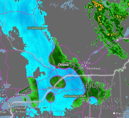
AccuWeather radar shows the precipitation changing from rain (green) to snow (blue) across eastern Ontario and the Ottawa Valley early Sunday morning. The snow will spread into Quebec later today.
Temperatures are dropping rapidly this morning in Montreal, behind a potent cold front. At 7:30 am, the temperature was 2C (36F) here on L'Ile Perrot, down from 7C (45F) at midnight. Rain has started this morning and will gradually change to wet snow this afternoon. The snow will persist into Monday, with accumulations of 5 to 10cm (2 to 4 inches) forecast for the city. Heavier snow and blowing snow is expected across eastern Ontario and far western Quebec, including the 401 corridor towards Kingston. These regions are under a snowfall warning through Monday. Accumulations in those areas, including Ottawa, will be in the 15 to 30cm (6 to 12 inch) range. Gusty northwest winds are already reaching 70km/h in southern Ontario, spreading into eastern Ontario and southern Quebec later today. Winds of 30 to 70km/h will persist into Monday afternoon.

Low pressure located over northeast Ontario will move into central Quebec today. A second area of low pressure is currently developing over southern New England and will lift into eastern Quebec. Abundant moisture, along with cold northwest winds, will produce snow over the entire region. The snow will not taper off until late Monday. The temperature will fall to -2C (29F) tonight and rise only to 0C (32F) on Monday. The Monday-morning commute will be challenging in Montreal, to say the least. Give yourself plenty of extra time.

Saturday, November 19, 2016

Calm before the storm for southwestern Quebec

Blizzard conditions pounded sections of Minnesota and northwest Ontario on Friday. Numerous accidents were reported along with several fatalities from the first storm of the season. The snow arrives in Montreal by Monday. (KARE 11 Photo via Twitter)
Dense fog has developed once again this morning in Montreal. The fog is expected to dissipate by mid-morning allowing sunshine to warm temperatures to 13C (55F). The record high for November 19 is 16.7C set in 1953. We have an outside shot at this, if the wind can shift out of the northeast. On Friday, a northeast breeze resulted in a high of 9C (48F) in Montreal. At the same time, over a dozen locations in Ontario reported record highs, including Windsor at 21.6C (71F), eclipsing the record of 18.9C set in 1971.

We now shift our attention to the first winter storm of the season. Low pressure over northwest Ontario this morning is forecast to move eastward into western Quebec by Sunday. A strong cold front will sweep across the St. Lawrence Valley overnight with rain developing. Temperatures fall rapidly behind the front, with rain changing to snow in Ontario during Sunday and towards Montreal by Sunday night. A special weather statement is currently in effect for southern Quebec as well as eastern Ontario. South of the border, winter storm warnings are in effect for the St. Lawrence Valley of New York, as well as the Adirondacks and Green Mountains.

So what does all this mean? Basically we are looking at a 24 to 36 hour snowfall from late Sunday into Monday night for the entire region. Amounts will be based on elevation and how rapidly any location changes form rain to snow. At this time, the heaviest amounts are expected across the mountains of southern Quebec and New England. However, western regions of our forecast district, including Cornwall and the Seaway Valley, may see 10 to 15cm of snow by late Monday. I think Montreal will settle into the 5 to 10cm range. Temperatures will turn much colder, and strong northwest winds are forecast, a far cry from what we have been experiencing so far this fall.

Friday, November 18, 2016

Wild weather weekend for Montreal: from record warmth to snow

Dense fog slowed the Friday morning commute in Montreal. Several accidents were reported, as the visibility fell to under 0.5 kilometres. (Valley Weather Photo)
A large winter storm continues to develop over central Minnesota this morning. This system has produced snow from Colorado northeast into western Ontario. Heavy snow and strong winds are creating difficult travel conditions for a wide area of the northern plains and upper Midwest. In excess of 30cm (1 foot) of snow is forecast for Thunder Bay and the surrounding regions of western Ontario. The storm is forecast to move east into Ontario and Quebec over the weekend. On the east side of the system, in advance of the storm, warm air will surge northward into southern Quebec. High temperatures are forecast to be in the low-to-middle teens today and Saturday in Montreal. Thick fog is expected for both mornings. Once the fog burns off, expect a sunny and warm day, with near record-high temperatures for Montreal.

A sign of the seasons; The Denver metro area had a record high of 27C (80F) on Wednesday. Less than 36 hours later, snow fell, causing hazardous driving conditions and hundreds of accidents. (AccuWeather)
First Snowfall for Montreal
On Saturday night, a strong cold front, associated with the aforementioned winter storm, will slide across eastern Ontario and into the St. Lawrence Valley. A period of steady rain is expected into Sunday, along with rapidly dropping temperatures and increasing northwest winds. By Sunday night, temperatures will approach the freezing point, with rain changing to snow in Montreal and southern Quebec. Snow is forecast, in varying intensities, through Monday morning. At this time, accumulations are very difficult to pinpoint, due to the warm weather in advance of the snow. However, expect a dusting up to as much as 10cm (4 inches) in some locations by Monday. Roads may be snow-covered and slippery, so prepare now for winter driving during the Monday morning commute. I will update this situation later today and over the weekend via The Suburban Twitter feed and Facebook page as well as at valleyweather.blogspot.com

Thursday, November 17, 2016

First snowflakes of the season expected in Montreal

Snowy commute on L'Ile Perrot, November 24, 2015. This could easily be the scene by Monday morning. Much colder weather and the chance of some snow is expected by the end of the weekend and next week. Get your snow tires on now.
Roughly in-line with 2015, the first snow of the season is forecast for Montreal by the end of the upcoming weekend. Before we reach that point, very mild air will surge northward into Ontario and Quebec to end this week. Clearing skies today will allow for moderating high temperatures to 10C (50F). Clear skies are expected overnight for the entire area, along with patchy fog. The forecast low will be either side of 0C (32F) in metro Montreal. Friday and early Saturday will be breezy and very mild, with high temperatures approaching the low teens. The record high for both Friday and Saturday in Montreal is 16.7C (62F) set back in 1953. We may have an outside shot at that Saturday, depending on how much sunshine we receive. This is where the good weather news comes to an end.

Install your snow tires NOW
Strengthening low pressure is expected to move from North Dakota into the western Great Lakes by Friday. This storm will provide the first blizzard of the season for portions of the western Great Lakes, upper Midwest and western Ontario. Strong winds will combine with 20cm (8 inches) of snow, to provide very poor travel weather along the Trans Canada Highway either side of Thunder Bay, Ontario by Friday morning. As this storm pulls east, a strong cold front will sweep across southern Quebec late Saturday. Temperatures will plummet from near record highs Saturday, as the coldest air of the season arrives. Daytime temperatures on Sunday in Montreal will actually fall most of the day. Overnight lows by Monday morning may be as cold as -5C (23F), with daytime highs on both Monday and Tuesday near 1C (33F). There is also a good chance rain will develop late Saturday and mix with snow by Sunday evening into Monday. Accumulations are difficult to pinpoint at this time, but expect slippery driving conditions early next week. Looking ahead into the middle and late portion of next week, the weather will remain cold in southern Quebec, with another chance of rain and snow by Thursday.

First snowflakes of the year expected in Montreal

Snowy commute on L'Ile Perrot, November 24, 2015. This could easily be the scene by Monday morning. Much colder weather and the chance of some snow is expected by the end of the weekend and next week. Get your snow tires on now.
Roughly inline with 2015, the first snow of the season is forecast for Montreal by the end of the upcoming weekend. Before we reach that point, very mild air will surge northward into Ontario and Quebec to end this week. Clearing skies today will allow for moderating high temperatures to 10C (50F). Clear skies are expected overnight for the entire area, along with patchy fog. The forecast low will be either side of 0C (32F) in metro Montreal. Friday and early Saturday will be breezy and very mild, with high temperatures approaching the low teens. The record high for both Friday and Saturday in Montreal is 16.7C (62F) set back in 1953. We may have an outside shot at that Saturday, depending on how much sunshine we receive. This is where the good weather news comes to an end.

Install your snow tires NOW
Strengthening low pressure is expected to move from North Dakota into the western Great Lakes by Friday. This storm will provide the first blizzard of the season for portions of the western Great Lakes, upper Midwest and western Ontario. Strong winds will combine with 20cm (8 inches) of snow to provide very poor travel weather along the Trans Canada Highway either side of Thunder Bay, Ontario by Friday morning. As this storm pulls east, a strong cold front will sweep across southern Quebec late Saturday. Temperatures will plummet from near record highs Saturday, as the coldest air of the season arrives. Daytime temperatures on Sunday in Montreal will actually fall most of the day. Overnight lows by Monday morning may be as cold as -5C (23F), with daytime highs on both Monday and Tuesday near 1C (33F). There is also a good chance rain will develop late Saturday and mix with snow by Sunday evening into Monday. Accumulations are difficult to pinpoint at this time, but expect slippery driving conditions early next week. Looking ahead into the middle and late portion of next week, the weather will remain cold in southern Quebec, with another chance of rain and snow by Thursday.