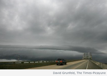
 Squalls move into New Orleans from TD 5.
(From NOLA.com )
High pressure has moved into southern Quebec this morning and produced a cool overnight. It felt like Autumn was in the air this morning with a slight chill. We should warm today under sunny skies to 25C. Yesterday turned out to be interesting in parts of the province, especially the higher terrain north and southeast of Montreal. Thunderstorms developed across theses regions as a result of the gusty west winds and some orographic lift. Some of the storms produced heavy rain and brief gusty winds. A rogue flash of lightning and bang of thunder nearly gave me heart failure during the lunch hour yesterday. I had conditioned myself to the fact there would be no thunderstorms yesterday. The lightning came from an isolated storm moving just north of the city across the north shore.
TD 5 is wringing out like a sponge over southern Louisiana this morning, with radar estimates showing 1 to 2 inches of rain per hour overnight across the area. Flash flooding is occurring with warnings in effect. Flooding is also occurring along a slow moving frontal system stretching from TD 5 northeast to southern New Jersey. This front will continue to be the focus for heavy rain today. The front is separating the warm and humid air to the south from the cooler, fall like air that has settled in across northern New England and the Great lakes.
No comments:
Post a Comment