Thursday, April 28, 2011

High winds cut power

100km/h winds in Kanata, Ontario


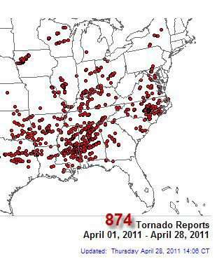
Low pressure that produced one of the worst severe weather outbreaks in US history took aim at Quebec and Ontario today. Fierce winds up to 100km/h spread across eastern Ontario and western Quebec toppling trees, cutting power to more than 125,000 homes and businesses, and killing at least one person in Ontario. The same system produced hundreds of tornadoes across the US yesterday from New York to the Gulf Coast killing at least 285 people and injuring thousands. Some towns and residential areas in hard hit Alabama were wiped off the map. So far this month almost 325 people have been killed in severe weather making it one of the deadliest seasons on record, at this time only surpassed by 1974.

The Royal Wedding
It is after midnight in London, England with the much anticipated Royal Wedding between Prince William and Kate to take place in just a few hours. The weather looks good with just a 10% chance of showers and temperatures around 17C. Here is a link to the Met Office in London for a closer look at the weather forecast.

Deadly tornadoes - flooding

There is lots to talk about this morning as twin low pressure areas have produced lots of heavy rain, flooding and a severe weather outbreak that has claimed over 175 lives. The hardest hit region from yesterdays severe weather remains the deep south from Alabama to Georgia and Virginia. Numerous tornadoes including a vicious storm that hit Tuscaloosa, Alabama have obliterated entire neighborhoods. This has been one of the deadliest tornado seasons on record and it is just beginning.

HIGH WIND WARNING
Further north heavy rain across New England dumped between 1 and 3 inches on already swollen rivers and lakes. Flooding is widespread in New York and extreme southern Quebec. More rain is falling this morning in Montreal with about 20mm reported already. We remain chilly with the cold air trapped in the valley. Montreal is only 10C while most neighboring regions are 16 to 20C. More thunderstorms and heavy rain will occur today but the big story in Ontario and Quebec will be the wind. High Wind warnings are in effect for Montreal and southern Quebec as well as areas adjacent to Lake Erie and Ontario. Look for winds to gust out of the southwest between 60-90km/h in the St. Lawrence Valley.

Notable events yesterday besides the dozens of tornadoes across the deep south were a possible tornado near Fergus, Ontario and a peak wind gust to 107km/h in Waterloo, Ontario.

Wednesday, April 27, 2011

Severe Thunderstorm Watch

A severe thunderstorm watch is in effect for southern Quebec and eastern Ontario this evening. As expected warm air surged into the region today with the exception of here in the St. Lawrence Valley where we remain at a chilly 13C (55F) due to a persistent northeast wind. Meanwhile both Sherbrooke and Champlain, New York to our south hit 26C today or 79F. Meanwhile Ottawa was up to 22C. Tonight a cold front is slicing into that warm and humid air with heavy thunderstorms developing along the front in Ontario. The threat for severe weather will exist until midnight. Afterwards look for rain and moderating temperatures in Montreal overnight. Expect 25mm or more of rain with these storms in the next few hours.

A sever thunderstorm watch is also in effect for St. Lawrence, Clinton and Franklin counties in northern New York until 4am Thursday. Heavy rain along with snow melt at higher elevations has swollen many rivers and creeks in the region as well as Lake Champlain. Flood warnings remain in effect.

More rain

Fog is quite dense across the metro region this morning and it extends into eastern Ontario. Visibilities are under 1km in many locations. A warm front is in the process of moving north of the city and that will allow us to get into some mild air today. Montreal is at 7C but Burlington is up to 16C. Look for the fog to lift with partly sunny skies and temperatures warming into the low 20's. Showers and thunderstorms will redevelop again later today and overnight as another potent wave of low pressure moves northeast along the front from the upper Midwest. Look for some thunderstorms to produce gusty winds, heavy rain and small hail tonight across the region, especially in upstate New York. Further south in the warm and muggy air, severe thunderstorms and an elevated risk of tornadoes are possible in the US southeast and middle Atlantic. This has been a very bad month for tornado deaths and damage across the eastern third of the US.

On Thursday look for more showers and thunderstorms. The good news at this time is that it looks like a sunny and warm weekend for Montreal and southern Quebec as high pressure move into the region.

Tuesday, April 26, 2011

Thunderstorms

Accu Weather radar at 9:30pm

Lots of active weather across the region this evening as a warm front lies just to our south. Several waves of low pressure have been riding along the front producing cool temperatures and rain to the north and very warm temperatures and thunderstorms to the south. This afternoon while Montreal was around 12C (54F), Albany, NY was 28C (83F). Some storms have become quite severe across the southern tier of New York state with several tornadoes reported. Small hail was also reported in eastern Ontario. In the last hour a series of storms crossed the Island of Montreal with thunder and frequent lightning along with heavy rain. Total rainfall amounts of 20-40mm have fallen across the region today increasing the flood threat south of the city in the Richelieu Valley as well as Lake Champlain where a flood warning remains posted. The lake is at 100.9 feet, flood stage is 100 feet.

We may see some of that warm air tomorrow with temperatures into the 20's. A cold front will bring more rain and thunderstorms beginning late tomorrow and continuing into Thursday.

Monday, April 25, 2011

Flooding expected tonight south of city

Flooding continued this weekend along Lake Champlain and the Richelieu River.

Another round of heavy rain is expected across southern Quebec, eastern Ontario and northern New England tonight. A Flood Watch is in effect south of Montreal across the Richelieu Valley and into northern Vermont and New York. Sharp rises on the Richelieu River occurred over the weekend as southerly winds pushed waters from Lake Champlain northward on into eastern shorelines. Several lakefront homes and basements were flooded. Quebec Civil Protection is fearful that tonight's rain, which could be in the order of 30-40mm, will only increase the flood risk. Low pressure over the Midwest with a warm front will approach the region by Tuesday morning with heavy rain along the front and a few thunderstorms. The rain will continue most of the day on Tuesday. The entire week will be unsettled with showers and thunderstorms. Until the front lifts north of Montreal temperatures will remain cooler than normal with northeast winds. Once the front clears the region, temperatures will warm to near 20C by mid week with mild overnight lows around 8C.

Saturday, April 23, 2011

Rainy Easter Weekend

April showers bring May flowers, remember that this week. It looks like a very unsettled weather pattern developing across the region for the better part of the upcoming week. In the near term showers are occurring this morning with more chilly temperatures (4C in Montreal) and very strong southeast winds. Gusts have been observed over 60km/h this morning in southern Quebec and they are forecast to approach 90km/h in the Champlain and Richelieu Valleys. Wind advisories are posted for those areas. Temperatures will eventually improve to around 14C or so, but this may not occur until later in the day. There were even some reports of wet snow again this morning across northern Ontario, the Laurentians and in portions of the Green Mountains. Easter Sunday will likely be the best day of the entire week as high pressure briefly clears skies out. Next week a series of low pressure areas and frontal boundaries will provide the area with showers and thunderstorms. There is a chance we may get into some warm and humid air by mid week but we will have to wait and see. Recent systems have had a difficult time pushing the cold and damp marine layer of air out of the St. Lawrence Valley.


Saskatchewan Flooding
Paul Boisvert, Editor of the Gravelbourg Tribune and my good friend and newspaper mentor has provided me with some photos of the spring flooding that is occurring across southern Saskatchewan. These pictures were taken as the Thomson Lake Reservoir south of Gravelbourg near Lafleche, Saskatchewan begins to empty into the Wood River that flows just to the south and east of Gravelbourg. As well other photos are from Aneroid and near Shamrock Park as the Notekeu floods.


Wednesday, April 20, 2011

Snow and rain

Ice pellets are slamming the window this morning here on the west end of metro Montreal. Precipitation is slowly lifting north along a warm front into the region. Low pressure over Michigan is forecast to move down the St. Lawrence Valley today and into northern Maine tonight. Heavy precipitation will spread along the northern flank of the storm along with very gusty winds. Montreal was relatively mild most of the night at around 5C but the temperature has since lowered to 3C as the precipitation begins. Winds are gusting to 50 and 60km/h out of the northeast across the region adding to the unseasonable chill.

Look for snow and freezing rain to change to rain today and taper off tonight. Storm totals of 25-40mm are forecast with most of that falling as rain south of the St. Lawrence and snow to the north. Warnings are in effect for most of the region for the variety of weather. The Laurentians and Townships as well as Quebec City can expect between 15-20cm of wet snow. Meanwhile it is at the freezing point in the Ottawa Valley with freezing rain. If you are travelling today expect difficult road conditions anywhere northeast and northwest of the city. To the south it will be a windy, rainy day across New England. Skies should slowly clear out late Thursday.

Tuesday, April 19, 2011

Stormy Wednesday

Dallas Morning News photo of wildfires creeping closer to the metroplex.

After a two day break in the weather more, cold, snow, freezing rain and sleet is forecast across the St Lawrence and Ottawa Valley tonight and Wednesday. Strong low pressure currently over the southern plain states will move rapidly northeast and down the St. Lawrence Valley. The system has a warm front in advance that will remain very close to Montreal tomorrow. Precipitation has already moved into southern Ontario in the form of showers and thunderstorms. The precipitation will overspread eastern Ontario after midnight and Montreal in the pre-dawn hours. Initially it will start as a mix of snow and sleet for Montreal before changing over to rain. A slushy coating to as much as 5cm is expected before the transition. Heavy Rain Warnings are in effect for the region with total amounts reaching 25-40mm. North of the valley snow is expected across the Laurentians and towards Quebec City where warnings are posted. Amounts may reach 15-25 cm with very strong winds up to 70km/h. Keep this in mind if you are travelling towards Quebec City. The same holds true for the Townships and Sherbrooke with less accumulation, perhaps 10cm. In Eastern Ontario a Freezing Rain Warning is in effect for the National Capital Region. Look for several hours of freezing rain and snow before a changeover to rain by noon. Across the upper Ottawa Valley and northeast Ontario look for snow to accumulate as much as 15cm.

Earlier in the week it appeared the storm would move well west of Montreal allowing the warmer air from the southern US to move in. Now with a track near or to the south of the city expect a cold chilly day with temperatures no better than plus 4C in Montreal and plus 1C to the north of the city. Winds will be gusty out of the northeast from 30-50km/h in Montreal and up to 70km/h in Quebec City.

TEXAS FIRES: The storm system is partly responsible for searing heat in Texas that has helped wildfires spread across the state. Close to 1 million acres have been charred with scores of fires burning out of control. Fires are even moving close to the Fort Worth and Houston metro areas. Drought this spring followed by the gusty winds and 90F heat has created very dry conditions and some of the worst fires in the history of the state.

Sunday, April 17, 2011

Potent spring storm

From WRAL, a tornado passes along I-95 near Dunn, NC.

Strong low pressure continues to lift north into central Ontario and Quebec this evening. A trough of low pressure spinning around the storm continues to produce frequent rain and snow showers in Ontario and Quebec. Over the last 24 hours the storm produced between 25-40mm of rain in Montreal along with several hours of sleet Saturday afternoon. The rain and snow was accompanied by strong winds that gusted to 70km/h in Montreal, and as high as 120km/h across portions of Vermont.

This storm had a trailing cold front that produced lines of deadly intense thunderstorms and tornadoes yesterday across the southeast and middle Atlantic states. Over 20 tornadoes were reported in North Carolina along with 22 fatalities in the state. The severe weather outbreak death toll attributed to this storm is now over 40 with hundreds injured. The region around Raleigh, North Carolina was hit hard with hundreds of homes and businesses damaged or destroyed.

Saturday, April 16, 2011

Heavy Rainfall Warning


Environment Canada has posted heavy rainfall warnings for Metro Montreal, and most of extreme southern Quebec. Further north across the central portion of the province snowfall warnings are posted. A potent storm system over Michigan is expected to move eastward into the province overnight tonight. A wide area of moderate to heavy precipitation is falling across Ontario this afternoon. The precipitation will edge into Quebec shortly. Despite the plus 5C reading at this hour some light ice pellets are falling in the city. This will rapidly change to rain with 30-40mm forecast in the next 24 hours. In addition to the rain very strong southeast winds will develop and gust over 60km/h. Further north across the northern Laurentians heavy snow is forecast with the potential for 15-30cm.

Further south across New York and Vermont, the big story will be the wind. High wind warnings are in effect across the spine of the Green Mountains and into the Adirondacks. Wind gusts of 40 to 60mph or close to 100km/h are expected. This storm has a trailing cold front that has a history of deadly severe weather. Over 15 people died yesterday as a result of tornadoes and severe thunderstorms that spread across Oklahoma, Arkansas, Mississippi, Alabama and Georgia. The severe weather has shifted east towards the Carolina's today.

Friday, April 15, 2011

Weekend Update

Close to 25cm of snow fell in Calgary yesterday (Calgary Herald)

Despite us being well into spring, clear skies allowed temperatures to drop this morning well below freezing between -4 and -10C. High pressure will give us a sunny but chilly day today with highs around 4C. The weekend unfortunately does not look very promising at this time. Low pressure developing over Kansas will move south of the region over the weekend. Clouds will be on the increase early Saturday followed by rain late in the day. The rain will continue into Sunday along with cooler temperatures and gusty winds. There may even be a few wet snowflakes around north of the city.

FLOODING
Winter is hanging on across parts of the prairies. Alberta was hit by a spring snowstorm yesterday with between 15-30cm of the white stuff from Edmonton south into Calgary. The snow slowed the major flooding that has been occurring across the region. Several Saskatchewan communities have declared a state of emergency after this winters significant snow began to melt rapidly. Water is flowing over numerous highways including the Trans Canada (below) at Indian Head. Flooding is also occurring in The Qu'Appelle Valley as well as near Lumsden and in Alberta near Medicine Hat. There is also flooding near Coderre, Sask south of Moose Jaw and near the Montana border in the Frenchman River Valley. Many areas have yet to see peak flooding with forecasters warning the floods could rival that of 1997 and 1974.

Flooding on the Trans Canada Highway near Indian Head, Saskatchewan.
(Sask Ministry of Transport)

Tuesday, April 12, 2011

More flooding in NY & Vermont

After the sunny and mild day today low pressure is approaching from the south this evening. Rain will arrive in the region by daybreak and spread from south to north. Look for a steady light rain most of the day tomorrow along with a brisk northeast wind and very chilly temperatures - no better than 5C in Montreal. There is even the risk of some wet snow in the higher elevations of New York, Vermont and New Hampshire. Speaking of the US, I know there are many readers from the North Country, as well as those who travel there or have property in Vermont and New York. The following was posted by the National Weather Service in Vermont regarding flooding along Lake Champlain:

FLOOD WARNING FOR LAKE CHAMPLAIN AT ROUSES POINT.
* AT 3:00 PM TUESDAY THE STAGE WAS 99.6 FEET. * FLOOD STAGE IS 100.0 FEET. * MINOR FLOODING IS FORECAST. * FORECAST...RISE ABOVE FLOOD STAGE BY WEDNESDAY EVENING AND CONTINUE TO RISE TO NEAR 100.1 FEET BY THURSDAY MORNING. * IMPACT...AT 100.0 FEET...WATER BEGINS TO ENTER SOME LAKE FRONT PROPERTIES. WATER ALSO BEGINS TO THREATEN LOW LYING ROADS... PIERS...AND DOCKS. WAVE ACTION CAN COMPOUND FLOODING ON WINDWARD FACING SHORELINES.

Seasonable weather returns

As expected a surge of warm moist air flooded into southern Quebec yesterday. Montreal reached 23.6C late in the day surpassing the normal high by almost 12 degrees. We tumbled down to our current temperature of 5C thanks to strong southwest and eventually northwest winds along a cold front. That front produced wind gusts over 70km/h in Montreal, knocking some tree branches down and disrupting power in several locations including on Ile Perrot.

Yesterday mornings thunderstorms were quite active especially south and west of Montreal. St Anicet on the St. Lawrence River recorded 42.2mm of rain, including 22.2mm between 5-7am in thunderstorms. Heavy rain also created serious flooding across upstate New York and northern Vermont. We Will have a break from the rain today with sunny skies and highs around normal, 11C. It will cloud over tonight in advance of the next weather system, strong low pressure lifting out of the southern US and along the Atlantic coast. Look for rain and chilly temperatures for Wednesday across the region.

Monday, April 11, 2011

Spring Thunderstorms

North Dakota National Guardsman patrol the levy protecting downtown Fargo from the Red River.

A warm front lifting northward across the region this morning has produced a wide area of showers and thunderstorms. The storms have been rattling around the Montreal area since about 3am with around 15mm or rainfall. Heavier storms have been affecting upstate New York and Eastern Ontario. Warnings were associated with those storms including flooding and hail. It should be quiet now for the balance of the morning with temperatures and winds on the rise. Highs will push 20C across the area, even warmer in places that see a peak or two of the sun.

A strong cold front will cross the region later this evening with more showers and thunderstorms. and much cooler temperatures all the way down to 3C tonight. Tuesday will be calmer and dry with seasonable highs of 11C.

Flood Warnings are in effect this morning just south of the border in Clinton County, NY with water over some of the roadways. Heavy rains from thunderstorms combined with snow melt is producing the flooding. Flooding is also occurring across the northern Plains and into the southern Prairies with major flooding reported along the Red River from Fargo north into Manitoba, There is also a high risk of spring flooding across Saskatchewan.

Friday, April 08, 2011

Weekend Update

Above: From the Montreal Gazette, the city will spend over 60 million to clean up the debris left behind by the winter. The annual spring ritual will involve nearly 700 employees. The same holds true for the off island suburbs.

TGIF, what a week it has been folks, sorry for the lack of updates, it has been a little hectic. Spring is upon us as the weather picture quiets across the country. As a matter of fact I could only find one weather advisory from coast to coast to coast and that is for the Town of Golden BC where a dust advisory for poor air quality is in effect - that's it folks.

Our weather will be dominated by high pressure today with bright sunshine and warming temperatures. it was a chilly morning with temperatures in the -2 to -4C range but it should warm nicely to 11C by afternoon. The weekend will start fair but an advancing warm front will bring us rain on Sunday followed by the cold front late Monday. Temperatures will be around 12C for the weekend. In between fronts, look for very warm air to surge northward on Monday, with temperatures approaching 20C across Ontario, Quebec and New England. It may even be a little humid on Monday and we can't rule out a thunderstorm along the cold front.

The last patch of snow will melt off my front lawn this morning, it was covered from December 7 to April 8, a very long and chilly winter. Lets hope there are no April surprises in in store for us.

Tuesday, April 05, 2011

Mild spring weather

It is a mild morning up and down the eastern seaboard as a strong cold front moves eastward. Temperatures soared into the low 80's as far north as Washington yesterday with 70's into the northeast. This morning Montreal was at 10C (50F) about an hour ago, but has since fallen back to 6C with the passage of the cold front. Temperatures reached 12C in Ottawa and 18C in Toronto. Yesterday we had about 10mm of rainfall with a little wet snow at the onset. Today will be breezy across the region with showers and falling temperatures. The good news is the balance of the week looks sunny with a slow warning trend that could see temperatures in the 15C range by the end of the weekend.

THUNDERSTORMS
That cold front this morning is pressing into some unseasonably mild and moist air along the east coast. At present a line of sever thunderstorms is moving into the coastal area from the mid Atlantic to the southeast. Severe Thunderstorm Warnings are in effect locally along with a large area under a tornado watch including Washington DC and the heavily travelled I-95 corridor. The storms will affect the region early this morning until about 11am when the front should clear the coast. Drier and cooler weather will move in behind the system.

**The last of the seasons snow is melting from my front yard this morning. If it goes today, the ground would have been covered from December 7 until early April, nearly 4 months since I have seen my lawn!

Sunday, April 03, 2011

Winter vs Spring

I often talk about the big snowstorm of March 1971 that influenced my interest in weather. Truth of the matter is that the entire 70's were filled with large and historical snowstorms. This brings me to today, 36 years ago, April 3, 1975. Historically April can be a month of summery weather or wintry weather. The month often features epic battles between winter and spring, and you are just a likely to have a snowstorm as a tornado.

APRIL RECORDS
April 3 historically in Montreal brings that battle to the forefront. Just last year the entire region had record setting high temperatures on this date. It reached 30C in St Anicet and 29C in Burlington Vermont. Montreal also had a record high at 25.7C. Ironically on this date in 1975 another record was established as a powerful late winter storm hit Montreal and the region. The low pressure produced a record setting 25.7cm of snow in 24 hours with 30cm total for the storm. During that 24 hour period, visibilities were never more than 1km. Winds with the storm gusted to 90km/h basically bringing transportation to a halt. The heavy wet snow also knocked out power. The storm also featured a very low barometric pressure of 980mb at Montreal, or the equivalent of a strong category 1 hurricane.

SNOW TONIGHT
The next 24 hours in Ontario and Quebec will reinforce the above statements. Strong low pressure over Iowa has already produced heavy snow across the southern Prairies with over 25cm in Calgary. This storm is pushing a warm front and an area of snow and rain northeast across southern Ontario at this hour and towards the Ottawa Valley. Wet snow will fall overnight in Montreal and Ottawa, with several centimetres possible before the changeover to rain in the morning. The rain will fall heavily at times on Monday with even the risk of a rumble of thunder over southern Ontario. Precipitation totals of 15-25mm are forecast with as much as 40mm in regions that see thunderstorm activity. Temperatures will cool to around 0C tonight, but rise to around 6 or 7C on Monday in Montreal and perhaps a little cooler in Ottawa.
Friday, April 01, 2011

Storm slides east

NOAA image of large storm this morning sliding just east of southwest Quebec and eastern Ontario.

Well computer models never really had a handle on this storm for southern Quebec. The flip flop between rain and snow had been going on for the last 48 hours. Now it appears this low pressure area off the mid-Atlantic coast this morning, will remain far enough east to limit any precipitation in our area. So warnings have been lowered in northern Vermont and New York. Where the storm will have an impact are the Green Mountains, White Mountains and the Townships from Sherbrooke south to the US border. In this area heavy wet snow will develop this afternoon and end on Saturday, with accumulations of 15-25cm forecast. So if skiing is your thing the weekend will be awesome in those regions with fresh snow on Saturday and clearing skies.

For the rest of us look for a light cold rain or wet snow to develop this afternoon along with gusty northeast winds and end overnight. I don't think Montreal will see more than 10mm of precipitation, mostly rain. The weekend calls for clearing skies Saturday along with near normal temperatures pushing plus 8C by Sunday afternoon.

A couple of signs of spring this morning - they were sweeping the streets on Ile Perrot when I left for work and believe it or not I had some plants poking out of the soil and through the light covering of snow left in my front yard, unreal!