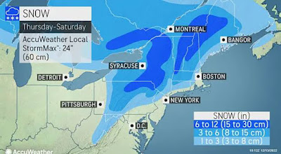
The first widespread winter storm is on the way for southern Ontario and Quebec as we head towards the end of the work week. It is however a very challenging forecast with several scenarios that could leave some locations with very little snow.
Over the weekend, low pressure skirted across Ontario and into New York, largely bypassing southern Quebec, with the exception of the Ottawa Valley, and the extreme southwestern corner of the province along the Ontario border. Only a trace of snow was reported at Trudeau Airport, with up to 1cm from Ile Perrot to Valleyfield, 5-10cm around Cornwall and 12cm in Ottawa.
That system is over the Gulf of St. Lawrence this morning, retrograding into Maine, and expected to deliver heavy snow and strong winds to eastern portions of the province.
Montreal will remain in between that storm and the advancing warm front associated with our next weather system, currently over the central plains. The week will be partly cloudy and seasonably cool for mid-December. By late Thursday, the aforementioned warm front will be lifting into New England, with a period of snow expected late Thursday into Friday morning for Montreal. On Friday, the forecast becomes quite complicated, with the computer models all over the place on the evolution of low pressure developing along the eastern seaboard and moving northeast.
The eventual track and strength of this storm will determine the type and intensity of the precipitation. At this time, it looks like Montreal will marginally cold enough for snow, with perhaps more than 15cm falling between Friday and Saturday. There are still many details to work out, but if you have any travel plans during this busy holiday season, expect some difficult weather this weekend.


No comments:
Post a Comment