 |
| After all the flooding in Montreal last weekend, it was nice to see the sun this week. Unfortunately the airmass is quite warm and humid, and has produced isolated thunderstorms. There has also been some smoke and haze from western wildfires. |
Severe Thunderstorm Watch in effect for metro Montreal.
We have a risk of isolated strong thunderstorms Thursday afternoon, with heavy rain, hail and gusty winds possible through sunset.
The clean up continues in Montreal after the historic rainstorm last week associated with tropical storm Debby. Highway 13 finally reopened Thursday morning, after being closed to flooding and a damaged pumping station since last Friday night.
 |
| Environment Canada map displaying the accumulated rainfall across our region from tropical storm Debby. The heaviest rainfall, between 150-200mm (6-8 inches), locally more, was centered in the St. Lawrence Valley, and particularly the West Island, Ile Perrot and Vaudreuil. |
Montreal has been under a warm and humid airmass this week, with frequent afternoon and evening thunderstorms across the southern portion of the province. The good news is that the storms have been widely scattered and have occurred in areas that received slightly less rainfall from Debby.
Montreal will remain in an unsettled weather pattern through at least next Monday. Primarily we will be affected by the departing upper level low to the east of our region, with scattered storms moving from north to south. As with any thunderstorms, heavy rain is possible, but it will not impact the entire island as Debby did. Temperatures will be quite warm Thursday through Saturday, rising to near 30C (86F) as it did Wednesday afternoon.
Over the weekend, we have another Great Lakes low pressure and associated frontal boundary expected to slide across southern Quebec. Showers and scattered thunderstorms are likely each day, with the possibility of 15-25mm of rain falling by Monday, perhaps more in thunderstorms. The hope is we avoid any additional flooding.
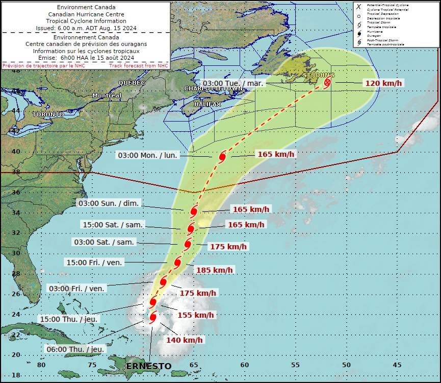 |
| Hurricane Ernesto's forecast track will keep the storm far away from southwestern Quebec. The only Canadian location that will likely be impacted is Newfoundland. (ECCC) |
HURRICANE ERNESTO
It is important to note that hurricane Ernesto will not impact the weather in southern Quebec as some were posting on social media Wednesday. The storm will be far out in the open waters of the North Atlantic.
Ernesto strengthened into a hurricane Thursday morning, 915 km southwest of Bermuda with 140km/h winds. The storm was moving north at 22km/h. A hurricane warning is in effect for Bermuda, with the centre expected to pass close to the island nation Saturday as a major hurricane. The storm will produce dangerous surf all along the US coast and into Atlantic Canada. Ernesto may brush Nova Scotia, but most likely will affect southeastern Newfoundland sometime next week.
No comments:
Post a Comment