Thursday, July 31, 2014

Warm west - cool east

Waterspouts are possible over the Great Lakes again today.
It is another chilly morning here on L'Ile Perrot with the temperature sitting at 15C (59F) after an overnight low of 13C (55F) around 6am this morning. We have some sunshine around as well as some mist and fog. As I have said all week, it feels more like a September morning than late July. Sadly my favorite month of the year is over, and it will end on a cool note with highs forecast near 21C (70F). A rather vigorous upper air disturbance will provide enough lift for scattered showers and thunderstorms today as it drifts from Ontario into New England. Some of the storms may have small hail and heavy rain. On Wednesday several decent storms affected the Ottawa Valley with over 23mm of rain for the nations capital. We may see similar amounts today, but not for everyone, they will be scattered in nature. Showers will taper off this evening followed by a partly sunny Friday and a little warmer, up to 25C (77F). The threat for some thunderstorms will still exist Friday afternoon for Montreal. The weekend at this time looks sunny and warm. Let hope it holds.

The cool weather this morning stretches all the way down to the Gulf of Mexico with record lows at Pensacola, Florida of 64F and Mobile, Alabama at 63F, one degree off their coldest July morning on record. The cool air aloft has produced numerous showers and thunderstorms over the Great Lakes, several that produced waterspouts on Wednesday. The threat is there again today especially over Lake Erie. Waterspouts are similar to tornadoes but generally weaker. They can certainly upset smaller watercraft.

Meanwhile it is warm in the west with temperatures once again soaring into the middle 30's. Bow Island, Alberta hit 35.2C (96F) on Wednesday while Calgary was 32C (90F). Calgary also had a rare heat burst in the early morning hours of Wednesday. Heat bursts occur from collapsing thunderstorms. Around 1am, a gusty southwest winds hit 85km/h at the airport with a dry dewpoint of 1C (humidity was less than 15%). Meanwhile the mercury shot up to 29C (85F), almost desert like.

Tuesday, July 29, 2014

Feels like September

I am not certain where our summer went but I hope it returns soon. Officially at Trudeau Airport, Montreal has managed only four 30C (86F) days this summer, two each in June and July. Only one day over 32C (90F) has occurred, that was July 1st. Last year we managed nine 30C or warmer days in July alone.
Major flooding in Chester, Vermont on Monday. (Chester Fire Department)
 It was just a cold, miserable day on Monday across southern Quebec. Our temperature only managed to reach 18C (65F) for a high and that was early in the day. Most of the afternoon we were stuck at 16C (60F) with a cold northeast wind and rain. I recorded 11.7 mm of rain on L'Ile Perrot with a two day total of 27 mm. Other regions to our south had much more with 25-50mm (1-2 inches) falling from the Townships south into Vermont. In southern Vermont major flooding occurred around Chester and Andover in Windsor County. The rain swelled rivers damaging roads and bridges as well as several homes. Power was cut to over 1000 customers. The low pressure responsible for the lousy weather is now in northern Maine with high pressure building in briefly today. Partly cloudy skies can be expected from eastern Ontario into Montreal along with milder highs of 23C (73F), still well below normal. Wednesday and Thursday will see more clouds with the chance of a shower or thunderstorm as the upper low remains nearly stationary over the Gulf of St. Lawrence. Temperatures will warm slightly to 25C (77F) but we will have the ever present chance of a shower or thunderstorm into the weekend.


Monday, July 28, 2014

Rainy & cool start to the week

A rather vigorous low pressure area for late July is centered near Rochester, NY this morning. The system has a large area of rain and thunderstorms pivoting around it, and that area will move into southern Quebec and eastern Ontario this morning as the low moves towards Sherbrooke. It should be a rainy and cool Monday with even the chance for thunderstorms, temperatures will only be near 20C (68F) today and down to 15C (59F) tonight. The rain will be rather impressive with 25-30mm, around 1 inch generally throughout the region. Heavy rain is forecast across the Townships along with embedded thunderstorms. A rainfall warning is in effect for the Beauce and Eastern Townships where 60mm could fall. The rain should end by midnight. The rest of the week looks unsettled with showers and thunderstorms possible with a very slow warming trend.

On Sunday Montreal had about 17mm of rain, mostly in thunderstorms to start the day and scattered showers in the evening. We managed a muggy high of 25C (77F).

Thunderstorms produced major flooding in Toronto last evening with several roads impassable. (Global News)
The same system drenched southern Ontario on Sunday with 50-100mm (2-4 inches) of rain in thunderstorms. High winds cut power, trees fell on homes and cars and even a funnel cloud was reported in the southwest. Flooding occurred last evening on several major GTA highways including the 401. The OPP took to Twitter to recommend drivers stay off the roads and definitely not drive through standing water. The photo shows above some did not head that advice.

Thursday, July 24, 2014

Much cooler - less humid air arrives in Quebec

Lightning is believed to have sparked this fire in Derby, Vermont near the border with the Eastern Townships. Strong thunderstorms Wednesday brought an end to the heat and humidity across the entire region. (WCAX 3 News)
My vacation week is slowly melting away, not much going on this year as life has kept me from my usual trek to a beach...any beach. The heat and humidity that started the week has been chased out by Wednesday's cold front. Depending where you were in the region, that front either went through with a whimper or a bang. Thunderstorms in the early part of the day swept eastern Ontario, Montreal and southern Quebec with around 10-20mm of rain and frequent lightning. The storms managed to cut power to nearly 30,000 homes mostly off island in Vaudreuil/Dorion as well as in Stormont, Dundas and Glengarry County, Ontario. What had been a sultry night with temperatures in the middle 20's quickly became refreshed with the frontal passage. The same front produced heavy thunderstorms in Vermont and New York that cut power, knocked down trees and started several fires in homes. The storms were also responsible for yet another person injured by lightning this summer, this time at a campsite in Waddignton, New York near Massena.

The front pushed the hot weather to our south and east with highs only in the middle 20's in Montreal yesterday. Meanwhile the high heat was across Atlantic Canada with several record highs recorded as the mercury hit 30 to 32C. This morning Montreal is dry and much cooler at 17C (63F), quite a change from the low 30's of Monday and Tuesday. It will be a dry day with a northwest breeze and highs near 24C (75F). Clear and cool conditions expected tonight with lows around 14C (56F). Friday and Saturday look good with sunshine and highs near 26C (79F). We will see an increase in clouds on Saturday followed by a chance of showers late in the day and into Sunday. Sadly it looks cloudy, showery and cooler as we head into the last week of July. Another pool of much cooler than normal air will cross the Great Lakes and become established by early next week.

Monday, July 21, 2014

Warm & humid - strong thunderstorms Wednesday

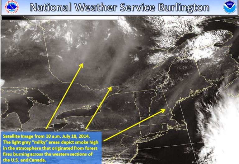
The yellow arrows show smoke over Ontario drifting into Quebec and New England late last week and into the weekend. The haze and smokey air is travelling along the jet stream from wildfires burning in Alberta and B.C. (NWS Burlington)
Well almost immediately after I guaranteed a spectacular weekend on Friday, mother nature began to challenge that claim, at least for some of us. A colder than normal air mass over the Great Lakes managed to produced afternoon clouds and even some scattered showers over Ontario as far east as the Ottawa Valley. However sunshine and only some high cloudiness prevailed in Montreal. Temperatures responded in the sunshine making it to 28C (83F) on Sunday for metro Montreal, while it was only 23C (73F) in the clouds in Toronto. Another shot of much cooler than normal air will arrive in Ontario and Quebec and the US Midwest by Thursday but until then it will be very warm and humid. Partial sunshine can be expected both today and Tuesday in southern Quebec with just some high clouds and perhaps some haze and smoke form the western wildfires. Highs will make it close to 30C (86F) both days. On Wednesday a cold front will arrive with clouds and showers along with the risk of a few strong thunderstorms. Highs will be cooler reaching 26C (79F). By Thursday sunshine will return with a much drier and more comfortable air mass and highs near 22C (72F).

The moist, unstable air has Toronto down to 1 kilometer visibility in fog and mist this morning, with a special weather statement in effect for much of southwest Ontario for dense fog. The fog should burn off in the next few hours, but until then travel is slow with visibility locally as low as zero on some highways.

Friday, July 18, 2014

Nothing but sunshine for southern Quebec & Ontario

A beautiful rainbow over the West Island of Montreal last night signalling the end to a brief shower and the start of a spectacular period of weather! (ValleyWX Photo)
 Vacation time is upon us for many and the weather looks nearly perfect. A ridge of high pressure is slowly moving across the Great Lakes and into Quebec today with nothing but sunshine, light winds and low humidity forecast through the entire weekend. Temperatures will range from 27-30C (81-86F), as I said perfect!

The high pressure in question will very slowly drift across Quebec and into New England this weekend and eventually off the east coast. The return southerly flow will increase the heat and humidity next week with highs moving into the low 30's, close to 90F by Monday. The same forecast holds true for northern New York, New England and most of southern Ontario. No rain is expected before Wednesday of next week at the earliest. Be safe and enjoy!

Wednesday, July 16, 2014

Perfect stretch of summer weather for Montreal

A massive tree crushes a car in
York, Maine late on Tuesday
.
Ok, so I should have left my forecast alone yesterday. But I must admit the radar looked impressive in Ontario and most of us really thought Montreal would see a decent shot of heavy rain and thunder through the middle part of the day. As with so many other days this summer in Montreal, it was not to be with only about 2-3mm, a splash in the rain gauge occurring near the noon hour. Otherwise it was a cloudy, damp day with all the big storms staying either north or south of Montreal, same old story this year.

Tho storms managed to dump 20-30mm of rain is some portions of the Townships,  notably near Granby. They also produced very heavy rain across New Hampshire with flooding observed as well as severe weather over portions of coastal Maine and New Hampshire. York, Maine was particularly hard hit with trees crashing onto homes and cars late in the afternoon. Power poles were also snapped across the Seacoast with numerous outages.

HEAT & HUMIDITY BUILD
The forecast for southern Quebec is looking great as we head into the upcoming weekend and the start of a very busy summer vacation period in this province. There is a slight risk of a few showers today, but otherwise sunny through next Monday. Temperatures will be around 25C (77F) for highs today into Saturday with lows near 16C (61F). Temperatures will rise this weekend and into next week along with the humidity, with daytime highs easily reaching 30C (86F) by Sunday and perhaps 32C (90F) early next week.

Tuesday, July 15, 2014

Strong thunderstorms with heavy rain for Montreal

I know I promised quiet weather this week for metro Montreal, but first we have to get through Tuesday. What looked like only scattered showers from a low pressure area and cold front is turning into a rather large area of heavy rain with embedded thunderstorms this morning. Heavy rain warnings have now been posted for the St. Lawrence Valley from Kingston to the Ontario/Quebec border. A severe thunderstorm watch for pretty much the same reason is now in effect for metro Montreal and southwestern Quebec. The front is moving into very moist, unstable and humid air and will trigger heavy downpours. Between 25-75mm (1-3 inches) of rainfall is possible in a very short period of time today from about 11am unti late afternoon for Montreal. Temperatures will be muggy near 25C. (77F). The weather should begin to dry out and cool off by Wednesday morning.

Monday, July 14, 2014

Decent weather week for Montreal - record heat in BC

A quiet weather patter is setting up for the week ahead across southern Quebec and Ontario. Sunshine today will allow temperatures to warm to near 26C (79F). There is a little humidity leftover from the 13mm of rain on Sunday, but it should remain clear and dry. Weak low pressure along with a frontal boundary will cross the St. Lawrence Valley on Tuesday with scattered showers and perhaps a thunderstorm. It will be another mild day, around 24C (76F). The frontal passage will allow for some September like air to stream across the Great Lakes with a couple of days of natural air conditioning forecast. Temperatures will be in the low to middle teens at night and perhaps 21C (70F) during the day from Wednesday into Friday. As the high drifts offshore into the Atlantic, much warmer and increasingly humid air will move into southern Quebec by next weekend with sunshine and highs in the upper 20's to near 30C (86F) by Saturday.

Dense smoke from forest fires like this one near Kakisa in the NWT is lowering air quality across western Canada. (CBC News)
WESTERN HEATWAVE
The big weather news this week will be the hot and humid weather across the Pacific Northwest, BC and Alberta. Parts of interior B.C. near Osoyoos hit a record 40C (104F) on Sunday, Lytton also set a record at 41.1C (106F) with hot air streaming north from the deserts of the southwestern US. The hot weather will prevail all week with forecast highs from 35C to 40C (95-102F) through Friday. The hot, windy weather and lightning strikes have increased the forest fire threat with nearly 140 fires burning in the Northwest Territories alone. Over 50 fires are burning in British Columbia. The fires have sent a plume of smoke south and east across portions of Alberta, Saskatchewan and Manitoba over the last week producing very poor air quality. The record highs forecast this week in B.C. will not help the situation.

Friday, July 11, 2014

Bright Saturday - humid, showery Sunday for Montreal

The weekend is upon us once again on this Friday morning, we start the day in Montreal at a pleasant 16C (61F) on our way to 27C (81F). Nothing but sunshine and low humidity today as high pressure crests over the region. Clear tonight with lows around 17C (63F). Saturday looks sunny once again but with cloudy periods as winds pick up out of the southwest and the humidity begins to creep up. Temperatures will be warm as well, 30C (86F).

On Sunday the weather pattern begins to change as a deep trough develops over the Great Lakes with energy moving down the St. Lawrence Valley by Tuesday. A warm front draped across southern Quebec will be the focus for showers and thunderstorms from Sunday afternoon through Tuesday night. Some of the storms could be strong on Monday with heavy rain possible. It will clear out by Wednesday next week. Temperatures will be near or slightly below normal for the period at 25C (77F).

Wednesday, July 09, 2014

High winds leave 100,000 Quebec homes in the dark

A massive tee was just one of hundreds toppled across western New York on Tuesday afternoon. (Syracuse.com)
A powerful line of thunderstorms and strong winds raced across Ontario, New York, Quebec and Vermont on Tuesday afternoon. The storms fueled by high heat and humidity, it reached 31C (88F) in Montreal, knocked down trees and power lines across a wide area. Thousands of homes went dark and remained that way for hours.

The carnage started in central and western New York early in the afternoon as significant damage from strong winds and isolated tornadoes was reported around Syracuse. In Madison County, NY, 4 people were killed after their homes were flattened by wind and thunderstorms. Power outages to over 250,000 homes and businesses were reported from Ohio and Pennsylvania into New York and Vermont by late afternoon. The front hit Montreal around 9pm Tuesday night with winds gusting between 70-90km/h across the entire metro region and Laval. Hydro Quebec reported over 100,000 customers in the dark across the province, 65,000 just in metro Montreal. Hard work overnight by the utility has dropped that number to 16,000 this morning.

Hydro Quebec was busy overnight restoring power to 100,000 Quebec homes and businesses. Between thunderstorms and tropical storm Arthur, the utility has had a crazy busy week. (CJAD)
Here on L'Ile Perrot around 12mm (0.5") of rain fell with the storms between 7 and 9pm, there was very little lightning, and winds over 50km/h. The front has broken the suffocating humidity, humidex readings were as high as 37C (100F) on Tuesday. Today will be cloudy with breaks, windy and cooler with highs near 24C (76F), and less humid. The heat and humidity will break until Saturday when it will begin to build again.

Tuesday, July 08, 2014

Warm & humid Tuesday for southern Quebec

Several times this summer it looked like Montreal was in line for strong to severe thunderstorms, but fortunately they have not materialized, at least in the city proper. Just this month alone there have been at least three days, including Monday, where the parameters and ingredients were right for thunderstorms. But like the previous two days, none developed on Monday in Montreal. The main area of thunderstorms once again moved across portions of Ontario and into central New York and southern Vermont. We did however have showers for a big portion of the day with a light rainfall of 5-10mm in most metro locations, just enough to water the lawn. There were some reports of 20-30mm closer to the US border and just across it in Vermont.

The warm front the caused the showers Monday is now well east of the region with Montreal in the warm sector. Temperatures are already in the middle 20's, look for warm, muggy highs of 29C (85F) today. A rather vigorous cold front will cross the region late this evening with showers and thunderstorms possible in Ontario, Quebec and New York from the supper hour to around midnight. Lows tonight will be around 20C (68F) with highs on Wednesday at 25C (77F). Some showers may linger into Wednesday but there will also be a few glimpses of sun.Thursday into the early portion of the weekend looks good with plenty of sunshine and seasonably warm. It will become more humid with thunderstorms by Sunday.

A photo of just some of the damage on the farm of Ray Derdall near Outlook, Saskatchewan. He also had major damage done to his home. (Star Phoenix)
SASKATCHEWAN TORNADOES
Environment Canada was out investigating the weekend tornadoes across Saskatchewan. Six tornadoes were reported between 2:30 and 4pm Saturday afternoon. The strongest occurred near Outlook, and was an estimated EF2 capable of winds between 178-217km/h. Major damage was reported on one farm near Outlook.


Meanwhile the cleanup continues in the Maritimes from Tropical Storm Arthur. There are still 65,000 homes and businesses without power in New Brunswick alone. It will take until the weekend to restore all customers.

In southern Manitoba major flooding continues along the Assiniboine River. Sandbagging efforts are well underway to try to alleviate some of the expected flooding in Brandon.

Monday, July 07, 2014

Strong thunderstorms possible for Montreal today - Arthur's aftermath

Above: I had friends visiting New Richmond on the Gaspe Coast this past weekend and they sent me photos of some of the tree damage from Arthur. Below: Hydro Quebec crews busy in the Gaspe restoring power to thousands. They will also send 40 crews to New Brunswick to help. (ValleyWX Photos)
  It was a very busy and wild weather weekend from coast to coast in Canada. Whether it was heat and humidity, fierce thunderstorms, strong winds or hurricane Arthur, we had a little bit of everything. Montreal remained on the western edge of Tropical Storm Arthur with high cloud cover and very gusty northwest winds. The winds across southern Quebec were in the 40-60km/h range most of the weekend. This resulted in scattered power outages across the region.


MONTREAL THUNDERSTORMS
Today we can expect a frontal boundary to slice into a humid air mass giving southern Quebec the possibility of strong thunderstorms. The main threat for Montreal would be from heavy rain and perhaps gusty winds up to 80km/h. The storms should begin by noon and last into the early evening. It will be warm and muggy with highs near 26C.

Fredericton, New Brunswick was hard hit by Arthur with numerous trees down and power out. (CBC News)
Tropical Storm Arthur
Arthur is now history this morning, dissipating over the far north Atlantic. The storm crossed the Nova Scotia coast early on Saturday morning with winds over 100km/h and heavy rain. While flooding and a small storm surge did occur, the big news was the wind. A peak gust to 139km/h (87mph) was reported in Greenwood, Nova Scotia, and winds well in excess of 100km/h occurred across a wide area of New Brunswick, P.E.I and eastern Quebec. Thousands of trees were toppled across Atlantic Canada and Quebec, many hitting homes and taking down power lines. The wind knocked power out to over 250,000 homes in Quebec and the Maritimes. Over 135,000 in New Brunswick alone making it the largest power outage in that provinces history. NB Power reports 155 crews restoring power with another 40 arriving from Hydro Quebec today. It may take until Thursday for all power to be fully restored.

Sunday, July 06, 2014

Outlook, Saskatchewan tornado


Severe weather across the country this weekend from tropical storm Arthur on the east coast to tornadoes in Saskatchewan and Manitoba. The video above from The Weather Network shows a large tornado near Outlook, Saskatchewan.

Saturday, July 05, 2014

Hurricane Arthur hits Atlantic Canada and the Gaspe

Flooding from Arthur in Yarmouth, Nova Scotia on Saturday morning. (CBC News)
The heavy rain and strong winds of now post topical storm Arthur are spreading across the Maritimes and eventually into Newfoundland this weekend. The western edge of the storm actually sent clouds into Montreal as well as gusty winds up to 50km/h from the broad circulation of the storm, but little else. The heavy rain and winds in excess of 100km/h are occurring across Nova Scotia, PEI and New Bruinswick as well as the Gaspe Coast. The center of what is left of once hurricane Arthur is currently located near the mouth of the Bay of Fundy, moving northeast at 23mph. Most of the heavy rain is occurring across Maine and New Brunswick this morning. Flooding has also been reported along the south coast of Nova Scotia. Yarmouth recorded a wind gust to 103km/h this morning, and nearly 150,000 homes are without power in the Maritimes. Several trees have already fallen onto homes with damage reported.

Rainfall will reach 100-150mm (4-6 inches) across portions of New Brunswick and the Gaspe/Lower North Shore of eastern Quebec today. Arthur will move into the Gulf of St Lawrence later this evening and into Newfoundland Sunday, slowly releasing its grip on Atlantic Canada.

On Friday Arthur pounded North Carolina before moving across the coastal waters of New England. Very heavy rain along the western edge of the tropical system along with a cold front produced nearly 200mm of rain in southeast Massachusetts. New Hampshire also had heavy rain and even a waterspout on Lake Winnepesaukee.

Friday, July 04, 2014

Arthur blasts the Outer Banks of North Carolina

Calm before Arthur: Mariners lock down boats in Nova Scotia prior to the arrival of Arthur. (CBC Nova Scotia)
The 120 mile long chain of barrier islands located off the North Carolina coast known as the Outer Banks, took a direct hit from Hurricane Arthur overnight. The low lying area is prone to flooding and that is what we are seeing this morning with water covering the only north south route, State Highway 12, under several feet of sand and water. Arthur made landfall last evening further south over mainland North Carolina near Beaufort Inlet and then crossed Hatteras Island back into the Atlantic Ocean. Peak winds across the Outer Banks were either side of 100mph overnight. The storm has since raced northeast at over 20mph and is now located off the coast in the Atlantic northeast of Kitty Hawk. Widespread power outages have also been reported but the very early assessment by emergency management has not reported any major damage or injuries so far with the exception of washed out roads. Hatteras and Ocarcoke Islands remain closed to visitors at this time. Rain and wind will slowly ease and seas subside today.

Winds whip waves across the Manteo/Nags Head Causeway in Eastern North Carolina Friday morning. The Outer Banks remain closed on this July 4th after Arthur pounded the region overnight. (13 News Now Weather)
Arthur will now move well off the Atlantic coast and brush Cape Cod before moving into Nova Scotia early Saturday morning. A tropical storm watch is in effect for coastal regions of Nova Scotia, New Brunswick and PEI. Rainfall of over 100mm, 100km/h winds and a storm surge can be expected starting late tonight and lasting into Saturday afternoon. Landfall of Arthur will likely occur near the Bay of Fundy early Saturday morning with the system crossing Nova Scotia and then heading into Newfoundland while weakening somewhat by Sunday. It will be a rainy, windy and wild weekend in Atlantic Canada.

Thursday, July 03, 2014

Hurricane Arthur to impact Atlantic Canada

On Wednesday Montreal reached 30C again with the showers and thunderstorms remaining south of Montreal as expected. A few thunderstorms moved across the Ottawa Valley late last night but again they manged to miss metro Montreal. Today will be warm and humid once again but this should be the last day for this current spell. A cold front will introduce clouds and showers by the middle afternoon with perhaps some thunder. Temperatures will be cooler today at 27C (81F) due to precipitation and cloud cover. Showers tonight and early Friday with much cooler weather expected, lows near 17C and Friday highs around 22C, natural air conditioning.

The location of Hurricane Arthur at 5am Thursday, July 3, as well as the anticipated track northeast towards Nova Scotia by this upcoming weekend.
HURRICANE ARTHUR
The first named hurricane of the 2014 season is located about 340 miles southwest of Cape Hatteras, North Carolina this morning. NOAA Hurricane Hunters had the storm reaching hurricane strength (category 1) of 75mph this morning at 5AM. A strengthening of the storm is forecast and winds could reach 85-95mph today. The system is moving towards the north at 9mph. A hurricane warning is in effect for the North Carolina coast as far north as Virginia Beach. Mandatory evacuations started this morning along the Outer Banks of North Carolina, particularly Hatters and Ocracoke Islands. As I mentioned yesterday, I am very familiar with the geography of the Outer Banks and any type of storm is problematic for the low lying barrier islands. Airing on the side of caution, and on the eve of the 4th of July weekend, evacuations were ordered. The initial affects of the storm will be rising surf and wind late this afternoon. Up to 150mm (6 inches) of rain along with winds in excess of 100mph are possible by early Friday. In addition, a storm surge of  2-4 feet is possible with coastal flooding expected.

By late Friday and into the weekend the system will accelerate northeast towards Nova Scotia with landfall as a category 1 hurricane or strong tropical storm likely on Saturday very close to Halifax according to computer models. Heavy rain, strong winds and a storm surge are expected for portions of Nova Scotia, PEI and perhaps the Gulf of St. Lawrence in Quebec and New Brunswick. The details will be more refined and watches or warnings posted later today or early Friday.

Wednesday, July 02, 2014

Record high 33C for Montreal

A heat warning remains posted by Environment Canada for southwest Quebec as heat index values approach 37C (100F) once again this afternoon. Tuesday was the warmest Canada Day ever in Montreal as the mercury officially hit 33.2C (91.7F) at Trudeau Airport. The previous record was 32.5C from 1963. It remained warm overnight dropping only into the low 20's,  we are sitting at 26C (79F) already at 8am this morning. Temperatures will be a degree or two cooler today but remaining humid with highs near 31C (88F). The record today, also from 1963, is 34.4C.

The forecast for the most part was dry on Canada Day for Montreal with thunderstorms remaining over the Laurentians and Ottawa Valley or well south of Quebec in central New York. The storms were fast moving but did produce some wind damage across the lower Laurentians. Today's risk for storms is rather low for Montreal with the main dynamic south of the city across New York and Vermont and perhaps into the Sherbrooke area.It will remain hazy and humid in southern Quebec into Thursday with lows tonight near 22C and highs Thursday once again approaching 30C. A trough will bring showers and thunderstorms late Thursday with cooler and dryer weather arriving by late Friday. The weekend looks sunny with near normal temperatures.

A spectacular visible image of a strengthening tropical storm Arthur east of Florida this morning. Note the thunderstorm tops bubbling high into the atmosphere. (NOAA)
ARTHUR
Tropical storm Arthur developed as expected on Tuesday and now has 60mph winds. The deepening storm with impressive convection is located a few miles off the Florida coast about 495 miles south of Charleston, South Carolina, moving north at 6 mph. This morning tropical storm warnings are in affect along the Florida coast, with a hurricane watch posted along the fragile North Carolina coast including the Outer Banks south of Oregon Inlet. Arthur is forecast to intensify into a minimal hurricane while approaching North Carolina by Friday. Heavy rain and high surf will be the primary threat at this time. I have vacationed on Hatteras Island since 1991 and this region is highly vulnerable to flooding from both the ocean and sound. Beyond the Carolina's the storm could bring high winds and rain to Nova Scotia and PEI by this weekend.

Tuesday, July 01, 2014

Warmest day of 2014 for Montreal - strong storms likely

Happy Canada Day.
We are warm and very humid this morning in Montreal as temperatures start the day in the mid 20's. Currently I have 25C on L'Ile Perrot but with an 83 per cent humidity, it feels quite uncomfortable. A heat warning is in effect for eastern Ontario and southwest Quebec. Temperatures will warm under hazy sunshine to 33C (92F) today with heat index values close to 38C (100F) for metro Montreal and the surrounding region. As always try to limit extreme outdoor activities and drink plenty of water. Temperatures will remain warm tonight, dropping to 23C and warm again on Wednesday at 30C. It should turn cooler and less humid by Thursday.

SEVERE THUNDERSTORMS
The other threat today will come in the form of strong thunderstorms. A cold front moving into Ontario and Quebec will trigger these storms, and with plenty of moisture and energy available they could be quite strong. The threat will begin early this afternoon in western Quebec and Ontario, and spread towards metro Montreal by the supper hour. Already this morning a severe thunderstorm watch has been posted north and west of Montreal. With today being a holiday and many outdoor activities scheduled, it is important to be aware of any potential severe weather and warnings that may be issued later today for Montreal. The main threat will be strong winds and possible hail. There is also the risk of an isolated tornado in regions northwest of Montreal and across southern Ontario.

The current forecast track of Arthur may take it towards Nova Scotia by the weekend. (NHC)
Tropical Storm Arthur
Forecasters at the National Hurricane Center in Florida are tracking the first tropical system of the young 2014 season in the Atlantic basin. Depression one will likely become tropical storm Arthur today as winds reach 39mph. The storm is forecast to slowly develop just off the US southeast coast. It is forecast at this time to remain just offshore with heavy rain (3-5 inches) and rough surf expected on the coast from northeast Florida to North Carolina. The potential is there for Arthur to become a hurricane by the weekend near the Outer Banks. We will have to watch this system closely as the potential is there for some weather to affect Atlantic Canada by the weekend. At this time the New England beaches look to be spared from a direct hit, however the surf will be rough.

Sunday, June 29, 2014

Heat Advisory for Metro Montreal

It was a sultry day across southern Quebec on Sunday with temperatures in the low 30's including 31.3C (88F) here on L'Ile Perrot. Factor in the humidity and it felt closer to 40C Sunday afternoon. Some showers and thunderstorms are occurring in the hot and humid conditions across Ontario and they may spread briefly into Quebec as well early Monday. Environment Canada has issued a heat warning for metro Montreal for Monday with hazy weather forecast and highs near 32C (90F). Humidex readings in the afternoon will once again approach 40C. Drink lots of fluids and don't over exert yourself outdoors. A cold front will bring some relief by Canada Day but also strong thunderstorms with the risk of severe weather including hail for Montreal during the afternoon hours. More on that threat as we get closer to the event.
Major flooding from 100-200mm of rain is being reported in Saskatchewan and Manitoba including Regina (above).
Prairie Flooding
Meanwhile severe flooding is occurring across southwest Manitoba and southeast Saskatchewan. Numerous roads are closed due to flooding including the Tran-Canada Highway near Moosomin. Major flooding has occurred in Regina and rain swollen rivers are starting to put pressure on the lakes region around Winnipeg. Strong storms dumped between 100-200mm (4-8 inches) of rain this weekend. In addition winds have brought down trees and power lines in Winnipeg. Brandon is under a state of emergency after 117mm of rain in the last 24 hours. Major overland flooding is occurring with fields and crops under water and highways washed out. Nearly one dozen Saskatchewan communities are under a state of emergency including Yorkton and Melville.

Friday, June 27, 2014

A perfect weekend for Montreal - sunny & hot

The rain is over for the time being. We are looking at what has been a very wet June in Montreal with nearly 170mm of rain at Trudeau Airport for the month, over double the normal. Other portions of southern Quebec have had even more. A state of emergency remains in effect in Saint-Colomban northwest of Montreal where nearly 100mm of rain fell last Tuesday alone, washing out many roads and flooding homes. Lachute reported 82mm of rain and Montreal 50mm. The slow moving system was across southern and eastern New England as well as Atlantic Canada Thursday with more heavy rain and isolated flooding.

A flooded underpass in the Cartierville district of Montreal on Tuesday night. This is why you do not drive your car into any standing water. Turn around don't drown! (CBC News)
SUNNY & HOT
For now high pressure will build into southern Quebec with another ridge building north from the Atlantic. The combination will drive up the temperatures as well as increase the humidity in Montreal. We managed 27C (81F) on Thursday with highs forecast either side of 30C (86F) through Canada Day. Overnight lows will be warm as well near 19C (66F). Nothing but sunshine through the long weekend with the next threat for showers and thunderstorms increasing by Tuesday.

Wednesday, June 25, 2014

Montreal flooding and another Ontario tornado

Several homes on Paquin Street in Ile Bizzard had to have their basements pumped by Montreal firefighters. (CJAD)
We had a very muggy, wet June 24 holiday in Montreal yesterday with showers and thunderstorms all day long hampering parades and B.B.Q's. The inclement weather was caused by a slow cold front moving south into very warm and mosit tropical air. The result was a day of thunderstorms across southern Ontario and Quebec. The rain accumulated about 12mm over the course of the daylight hours in Montreal, but really increased in intensity in the late evening as another 40mm fell. Over 30mm (1 inch) of that fell in just over one hour between 10:45 and midnight here on L'Ile Perrot. My total for the day was exactly 50mm (2 inches) with 40mm at the airport, and even more in other parts of the city. The heavy rain produced some flooding in several sections of the city including Ile Bizzard where at least 6 homes had major damage with up to 6 feet of water in their basements. Some highways also had to be temporarily closed by Transport Quebec to deal with water accumulation.
More tornado damage shown above in Ontario as the community of New Tecumseth was hit Tuesday afternoon by an EF-1 tornado. (The Weather Network)
TORNADO
In Ontario more severe weather was reported with an EF-1 tornado touching down in New Tecumseth, northwest of Toronto on Tuesday afternoon. The storm had winds in excess of 135km/h and was on the ground for at least 10 kilometers. Environment Canada will be assessing the damage today to provide more details on the 5th Ontario tornado this season. Another funnel cloud with rotation was reported closer to home in North Glengarry, Ontario. No damage was reported with that storm. Meanwhile Ottawa had 55mm of rain with flooding observed in several neighborhoods. Like Montreal, some city streets and highways had to be closed briefly as a result of water accumulation.

HOT WEATHER
What could be our first stretch of really hot summer weather is on the horizon. High pressure will pump warm and increasingly humid air from the US south into the St. Lawrence Valley and the Great Lakes starting as early as Saturday. It looks at this time like we could have several days of temperatures at or above 30C (86F) into next week. Until then temperatures will be in the 22 to 25C (72 to 77F) range with showers today and clearing skies on Thursday.

Monday, June 23, 2014

Warmer & more humid with thunderstorms by Tuesday

A variable sky on Saturday over Montreal with more clouds than sun. Sunday was a perfect weather day. (ValleyWX Photo)
After a great weekend, back to work Monday is looking much warmer and more humid. L'Ile Perrot is already at 19C (66F) early this Monday morning with nothing but sunshine. It will remain that way for the entire day with high temperatures pushing 28C (83F). The work week won't last long here in Quebec, as we have our provincial holiday tomorrow (Le Fete, St jean Baptiste Day), call what you want, it is a day off work. Unfortunately the sunshine will not last either. A frontal system will move into southern Quebec overnight with increasing clouds followed by showers and thunderstorms for Tuesday. Some of the storms may have very heavy rain. It has already been a wet month with nearly 130mm (over 5 inches of rain) here in Montreal. Normal rainfall at Trudeau Airport for June is 87mm, and we are well beyond that with a week to go. Temperatures tonight will remain warm near 20C (68F). On Tuesday cloud cover and showers should keep temperatures down between 21 and 24C (70-75F). It should clear out Wednesday with sunshine and a high near 24C (76F).

Friday, June 20, 2014

Spectacular weekend forecast for Montreal

Summer arrives at 6:51am Saturday morning and it looks like nothing but sunshine and warm temperatures for most portions of southern Quebec and eastern Ontario for the upcoming weekend. Temperatures in Montreal will warm from 22C (72F) today up to near 27C (81F) by Sunday. Overnight lows will be comfortable around 14C (56F), and humidity levels should remain low. The next chance for any precipitation will be late Tuesday as a frontal boundary approaches Quebec with the risk of showers and thunderstorms.

Major flooding is occurring yet again in southern Alberta. (CBC News)
Alberta Flooding
The weather has not been so kind in western Canada as a stubborn area of low pressure meandering around southern Alberta has generated heavy rain and even snow. Rainfall amounts in excess of 200mm (8 inches) since Monday has resulted in flooding around Fort Macleod, Magrath, Claresholm and Lethbridge County, Alberta. This is occurring one year to the date of the severe flooding last June that would eventually spread into Calgary. Flood watches and warnings are in effect across a large portion of southern Alberta, with a state of emergency declared in 11 communities so far.

What a weather week, flood, fire, searing heat, tornadoes and now a snowstorm! Heavy snow fell this week in parts of Utah and Wyoming.
Meanwhile the same system produced a very rare June snowstorm across the northern US Rockies with as much as two feet (60cm) of snow across the upper elevations of northwest Montana, Utah (above) and Wyoming.

Wednesday, June 18, 2014

Angus, Ontario EF-2 tornado

A major EF2 tornado races across Angus, Ontario late Tuesday. (Video Tina Forget)
Severe weather is in the news again across North America as an elongated area of disturbed weather stretches from the US high plains to the Great Lakes. On Monday twin tornadoes smashed into the tiny northeast Nebraska community of Pilger destroying 75 percent of the town and killing two and critically injuring 16. The same system has been producing very heavy rain across southern Alberta with over 100 mm (4 inches) reported in the Pincher Creek area. This is the same portion of Alberta where major flooding started last summer spreading into Calgary. More rain is forecast today as the system lingers.

Complete damage in the tiny Nebraska town of Pilger on Monday. (The Weather Channel)
ONTARIO STORMS
The eastern portion of the front raced through Ontario on Tuesday with widespread severe weather. In the early morning hours, lightning struck four golfers in Stouffville, Ontario, leaving one in critical condition. The quick work of an ICU Nurse nearby saved the mans life as she preformed CPR on the victim. It stresses the point I made in my last blog entry (see below) about how important it is to get indoors at the first threat of any lightning. The system also spawned a major EF-2 tornado around 5:30pm, capable of winds in excess of 200km/h. The tornado swept across a neighborhood of Angus, Ontario near Barrie severely damaging over 30 homes. Evacuations were ordered for 300 people. Roofs and sheds were torn apart, power poles were snapped in half, trees down and a truck flipped on its side. One person was injured according to local media. Environment Canada will be on scene today to determine the exact width and intensity of the tornado. Other regions of Ontario including Hamilton were under tornado warnings. Further east 104km/h winds cut power and toppled trees in Trenton. Heavy rain along the 401 corridor produced dangerous driving conditions with zero visibility in sudden downpours. Over 30,000 Ontario homes were left without power from the storms.

(Global News) Major damage was reported in Angus, Ontario. 

MONTREAL
As the system arrived in Montreal just after midnight early this morning, torrential rain fell with 24mm (1 inch) in less than 1 hour here on L'Ile Perrot. The system has now raced off to the east and is already over Atlantic Canada. More showers and thunderstorms are possible in Ontario and Quebec today along a weak cold front before we see clearing and cooler weather into the weekend. Temperatures will be warm today near 26C before it cools to 22C on Thursday.

Sunday, June 15, 2014

Lightning Safety


At any given second, lightning is striking the earth somewhere, nearly 2000 thunderstorms are active around the earth every minute! Lightning is responsible for numerous death and injuries, and tons of damage to homes, electrical devises and power grids. Numerous fires are also started by lightning.

First of all, there is no safe place outdoors during a thunderstorm, your best defense, get inside. While your chances of being struck by lightning are slim, 10 Canadians pay the ultimate price for that gamble in an average year. Another 150 to 160 are injured, some with injuries that will stay with them for life. The average bolt of lightning contains enough energy, 300 million volts in a typical flash of lightning, to light a 100-watt incandescent light bulb for about three months. The air displaced by lightning is heated to a temperature 5 times that of the sun, nearly 28,000C, (50,000F) enough to melt car tires and burn skin. If you are stuck outside, get as low as you can, make yourself as small as possible.

I took this picture near my home in Kemptville, Ontario back in 2009. Lightning occurs quickly and is one of the top weather killers in North America. (ValleyWX Photo)
One of the myths about lightning is that it never strikes the same place twice. Note that the Empire State building in New York City is struck an average of more than 100 times each year. Rule number one, lightning likes tall objects, stay away from trees. Most deaths across North America are from those who seek shelter under a tree during a thunderstorm, it is one of the worst places you can be. Another is anywhere on or near water. Head ashore as soon as threatening weather approaches. You should always know the risk of thunderstorms when boating or at the beach. Keep a weatheradio with you at all times, they are cheap and could be a lifesaver, or download one of the may weather applications for your smartphone.

Lightning can strike more than 5km from the parent storm, so as soon as you hear thunder, head indoors. Refrain from outdoor activities such as swimming, soccer or golfing for at least 30 minutes after the last thunder occurs. A recent study by Environment Canada indicated that as little as 3-5% of individuals injured or killed by lightning in Canada are by a direct hit. Most occur by ground current (40-50%) or side flash (20-30%). That is why it is so important to refrain from using electrical appliances such as phones or computers that are hardwired directly to your home. Cordless items are fine to use. 

You are relatively safe inside a car, however if a car is directly hit, significant damage, including fire and blown out windows can occur. Just last week a couple from Tofield, Alberta had their truck struck by lighting. The vehicle became engulfed in a fireball and filled with smoke. It rolled to a stop with the electrical system destroyed. They were rescued by a passing RCMP officer. I posted a still image above taken form a nearby security camera.

Another myth, is that people struck can't be touched. A person struck by lightning is safe to handle immediately, they may need CPR or other medical attention. 

Thursday, June 12, 2014

More heavy rain today

NOAA water vapor radar image showing deep moisture streaming north from the Gulf of Mexico towards Quebec this morning.
 The digital rain gauge is showing 39.2mm as of 7am this morning here on L'Ile Perrot, most of that falling overnight. The NOAA water vapor radar image above shows the trail of deep moisture running from the Gulf of Mexico northward into southern Ontario and the St. Lawrence Valley. A special weather statement for upwards of 50mm (2 inches) of rainfall is in effect for Montreal. Judging by the fact we are already at 40mm we may see a little more than that. Meanwhile heavy rain warnings are in effect across eastern Ontario. Many locations have reported over 50mm in the last 24 hours. Trenton received 76.2mm (3 inches) in just the last 24 hours. Flooding was reported in the Niagara Region and along the north shore of Lake Erie. Severe weather with hail, flooding and wind damage occurred from Ohio to the middle Atlantic south into the Carolinas.
Flooding from heavy rain in southern Ontario on Wednesday. (Photo: Twitter @ErieMedia)
SUNNY WEEKEND
The rain has come in waves along with embedded thunderstorms, and that will continue across the entire region today. Temperatures are chilly this morning at 14C but should warm to 20C today under the clouds and rain. On Friday a cold front will produce more showers with thunderstorms. Skies should clear out Saturday morning with sunshine for the weekend. Temperatures will range from 21 to 24C for the weekend in Montreal.

Wednesday, June 11, 2014

Plenty of rain to end the week for Quebec & Ontario

A sign of hope on a very difficult day in Moncton, New Brunswick on Tuesday. Thoughts and prayers to all involved.(CBC Nova Scotia via Twitter)
A moist weather system from the central US will help draw rain and thunderstorms northward across the eastern US and into the St. Lawrence Valley for the balance of the week. This morning we have sunshine in Montreal with warm temperatures in the high teens. The sun will rapidly begin to fade behind increasing clouds today as we reach 24C (76F). Radar shows rain and thunderstorms across Pennsylvania and Ohio moving into southwest Ontario this morning. The area of precipitation will slowly move into Quebec by this evening. Rain could be heavy at times with slow moving showers and storms. The same system on Tuesday produced flash floods across Metro Washington D.C. as well as portions of Maryland, so there is a history of flooding.

Environment Canada has issued heavy rain warnings for 50-70mm (2-3 inches) of rain across the Ottawa Valley as well as Eastern Ontario. In Quebec we currently have a special weather statement with no active warnings at this time. Forecast amounts here are in the 25-50mm range (1-2 inches) over the next three days. The good news is I think the system will be east of our region by Saturday morning with just clouds left to clear out. The weekend should be fair with warmer temperatures for Montreal, southwest Quebec and Ontario.

Lightning Safety Week in Canada is June 9-15
When the thunder ROARS go INDOORS!
Lightning kills an average of 10 Canadians each year while injuring over 150. I am preparing a blog post for tomorrow featuring more information and ways to stay safe during summer storms.

Tuesday, June 10, 2014

Unsettled weather week ahead

What a spectacular weekend and Monday in Montreal and across the St. Lawrence Valley. The weather was ideal, perhaps a little too hot, for the  Formula 1 Grand Prix du Canada over the weekend. Temperatures were very close to 30C (86F) both Saturday and Sunday, dropping slightly to 27C (81F) on Monday.

This morning we have a northeast breeze along with clouds and showers that are keeping things cooler. I have 16C (61F) here on L'Ile Perrot, quite a bit cooler than last evening. A weak frontal system will bring showers this morning followed by afternoon clearing. Temperatures in Montreal will eventually make it to 25C (77F) once the clouds clear. Tonight should be fair with lows down to 15C (59F). On Wednesday southern Quebec will begin to feel the effects of a frontal boundary that stretches from the Great Lakes to the Gulf of Mexico. Deep moisture will flow northward with clouds increasing, we can expect the chance for showers and thunderstorms by late in the day. Temperatures will make it up to 25C once again. The showers will become a steady rain late in the day and into Thursday. Rain may be heay at times with in excess of 25mm (1 inch) possible. Friday looks wet as well with clouds and showers. The good news once again is that the weekend looks great. If so this will be the third in a row with sunshine and warm temperatures. Seems like a great way to start the summer, rainy during the week, sunshine on the weekends.

Thursday, June 05, 2014

The most important weather forecast in history - D-Day 1944

Friday is the 70th Anniversary of one of the most important dates of the 20th Century, D- Day, June 6, 1944. The invasion of the Allied Forces at Normandy would be the start of the liberation of mainland Europe and the eventual end of World War II. On this day, I want to express my gratitude to all those brave men and women who paid and continue to pay the ultimate sacrifice so that we can enjoy our freedom. Without them, none of this is possible.

It would be one of the most important weather forecasts ever delivered throughout history. Nearly 160,000 Allied Troops, including 14,000 Canadians, would be relying on its accuracy. The entire free world had a interest in this forecast being correct. It was the forecast for the English Channel during D-Day, the Normandy invasion, in June 1944.

Supreme Commander of the NATO forces, General Dwight D. Eisenhower needed nearly ideal weather conditions to launch the invasion. The perfect day would have a full moon, low tides, clear skies, light winds and low seas. Two such periods matched the low tide scenario, but only one had the light of a full moon, June 5, 6 or 7, 1944.

Destroyed military equipment lies in the surf at Juneau Beach on D-Day, June 6, 1944
The prognostication fell on the backs of a team of forecasters from the UK and the USA, sprinkled with a few other Allied forecasters. The forecast team was lead by British meteorologist James Martin Stagg. Stagg lead three teams of forecasters who would argue back and forth for days testing each others abilities and theories to come up with the right day for the invasion of the Normandy Coast. The safety of the troops and the effectiveness of an entire campaign lay at stake.

It was up to the forecasters to give the best idea as to which 24-hour period would be best to launch the invasion. Early forecasts predicted stormy weather for the time frame in question. Eisenhower wanted a Beaufort Scale wind of 4 or less to give the go ahead. Force 4 winds are 13-18mph with 3.5 to 5 foot seas. Anything greater than that would swamp the landing craft and sink vital equipment. The challenges were many, so the hope was to give the landing forces the best chance possible. Any type of cloud cover would hinder air support and limit paratroopers.

American Troops landing at Omaha Beach, June 6, 1944
The massive Allied Force of nearly 200,000 troops, with over 6500 ships and hundreds of aircraft, began staging as early as June 3 in what had been up to that point a decent stretch of weather. That was about to change, as a series of low pressure systems and fronts travelling across the North Atlantic was about to bring very poor weather. By June 4th, the weather had turned with strong winds, low visibility, high surf and heavy rain. Stagg approached Eisenhower with his advice to delay the invasion and despite the US forecasters insisting the weather was acceptable for an assault, the General decided to wait 24 hours. Thousands of troops remained in place on ships in rough seas for an additional day. The armada was deployed instead in the early hours of June 5 for the 17-hour trip across the English Channel and a June 6 sunrise assault. Despite the 24 hour wait the weather was less than ideal with 5 foot seas, but a vast improvement over the 6 or 8 foot seas and poor visibility during the previous 24 hours. To show how devastating it could have been, even the lower wave action swamped several of the landing craft and left at least 2 dozen tanks submerged at Omaha Beach alone. This would lead to little ground support for Infantry, and massive casualties to the US forces.

The Germans were caught by surprise, as their forecasters had told German command the bad weather would last well into June and thus prevent any invasion. The rest as they say is history with the invasion succeeding but unfortunately at a terrible cost with as many as 10,000 casualties (dead & injured), including 1074 Canadians (359 Canadian deaths). Eleven months later Germany would surrender. You can never downplay the importance of D-Day in bringing World War II to an end. One can only imagine how much worse the invasion would have gone had Eisenhower decided to leave on the 4th while the cold front whipped up heavy rain and strong winds with very highs seas and low visibility. Stagg’s forecast to travel in the relative good weather between low pressure systems on June 5, 1944 no doubt lead to the success of the invasion, as well as saving countless lives.

By the time the initial battle came to an end, the sun was shinning along the Normandy coastline.

Wednesday, June 04, 2014

Big storms sweep city Tuesday

Heavy thunderstorms produced flooding on the West Island Tuesday afternoon. (Global TV)
A line of strong thunderstorms slowly crept across the Island of Montreal yesterday afternoon with strong winds and torrential rain. I measured 33.6mm of rain on L'Ile Perrot in less than two hours but as much as 47mm fell in Sainte-Anne-de-Bellevue and across the West Island. It was a little too much water for storm sewers and flooding resulted. Several roads were closed temporarily while the water receded. A couple of trees were knocked down as well in Pointe Claire and Hydro Quebec reported nearly 30,000 customers without power. The temperature managed a muggy 28C before the storms hit around 1:30pm.

FUNNEL CLOUD?
The ragged base of the storm cloud had some scud on the bottom (wind driven cloud). This is often mistaken for a funnel cloud which is being reported today on many media outlets as well as social media. I did not observe a funnel cloud on my side of the airport, just scud, however information provided to Environment Canada suggest one may have occurred near Trudeau Airport around 2:30pm. It did not reach the ground, and no damage or rotation was reported.

Tuesday, June 03, 2014

Wet slow moving storms today for Montreal

SEVERE THUNDERSTORM WATCH metro Montreal for the day today for strong thunderstorms capable of heavy rain.

It has been a rather warm and muggy 24 hours in southern Quebec with temperatures in the low 30's on Monday afternoon. The warmth included a record 30.4C (87F) in both Ottawa and Montreal breaking the record high of 30C set back in 1970. Overnight lows remained very warm between 19 and 22C (66-72F). Today the region is expecting a cold front to slice through the muggy air this afternoon producing widespread showers and thunderstorms. I am not expecting severe weather with the storms today, that is hail or very strong winds, but the rain will be heavy. Some of the storms may produce upwards of 25-50mm (1-2 inches) of rainfall locally which could lead to some flash flooding in poor drainage areas. A watch or warning may be needed later today for portions of eastern Ontario and southwestern Quebec. Watch my Twitter feed for more details. Some sunshine may push us up to a muggy high of 27C (81F) today.

Once the front clears the region we can expect cooler temperatures on Wednesday, 22C, with showers and unsettled weather into Friday. The weekend is expected to be sunny both days with warm high temperatures of 27-30C (80-85F) both days.

Monday, June 02, 2014

Welcome to Meteorological Summer

Summer has arrived, at least according to meteorologists. Officially the summer solstice is June 21st, but the weather really starts to warm up quickly as of June 1st. Such was the case in Montreal this past weekend with much warmer temperatures in the middle 20's and total sunshine. It was a near perfect weekend. The good weather will continue into the start of the week, with even warmer temperatures today, along with an increase in humidity. We have an outside shot at the 1970 record high of 30C today, as we forecast highs near 29C (85F) for metro Montreal. Clouds will increase tonight, but it will remain warm and muggy with lows around 20C. Tuesday through the balance of this week will feature a very slow moving frontal system with cloudy skies along with frequent showers and thunderstorms. It will be warm on Tuesday in the middle 20's dropping to around 20C by Wednesday. The good news is that at this point next weekend looks sunny and warm.

With May over we can take a brief look at the numbers. It was a relatively warm month, even though it really did not feel like it. The average temperature was 14.4C at Trudeau Airport in Montreal, above the 20 year average of 13.4C. The highest temperature was 28.2C with the coolest 3.2C. Rainfall was measured at 95.6mm, the normal is 81.2mm. I had very similar stats at my home on L'Ile Perrot with extremes of 30.2C and 1.2C with an average of 14.4C and almost identical rainfall of 95.8mm.

Summer ice on Lake Superior. (NWS Marquette)
Here is some food for thought as we start summer, there is a blizzard warning in effect for Resolute, NWT today. At 6am this Monday, it was -4C, snowing with a visibility of 0.2km and 68km/h winds. The warning states to avoid all travel! On Lake Superior, ice continues to hug the southern shoreline. Despite the warmer weather huge chunks of ice are prevalent is many bays. The photos above are from the National Weather Service in Marquette Michigan.