Tuesday, December 06, 2016

Montreal weather video of Monday commute goes viral

Above and below: Beaver Hall Hill at Viger Avenue was the scene of a slow-rolling pile-up on Monday. A video capturing the event has gone viral, with millions of views. (Video by Willem Shepherd)
A video featuring Montreal's finest, along with a couple of transit buses, cars and even a City of Montreal salt truck, has gone viral. The video, shot by Willem Shepherd, was taken overlooking Beaver Hall Hill near the corner of Viger and has been viewed over 15 million times in less than 24 hours. I follow numerous weather sites and major networks, and it appears to have been featured on all of them. No serious injuries were reported, but I am sure several egos were bruised.


The pile-up was part of a nasty, Monday-morning rush-hour across southern Quebec and northern New England. A respectable 5 to 10 cm of snow fell over the course of Monday.  However, it was not the amount that caused the problem, but the timing. The air temperature was rather chilly overnight in the region.  As the snow started falling, it initially melted on contact with the slightly warmer pavement and refroze immediately, creating widespread black ice. The hills in the city quickly became polished skating rinks during the height of the morning commute. Numerous accidents were also reported in other parts of Quebec, as well as Ontario and northern New York and Vermont.

More snow is forecast for the Wednesday-morning commute, as another weak warm front approaches the city. Less accumulation is forecast this time, with perhaps 2 or 3 cm for the city. The light snow will mix with rain in both Ottawa and Montreal on Wednesday. Temperatures will be mild through Thursday, before an arctic front approaches southern Quebec. Expect highs above freezing Wednesday, but dropping by Friday night to -11C (12F). While the air will turn much colder, it will not be the frigid conditions forecast over much of western Canada. Blizzard conditions are occurring in southern Manitoba, with dangerous windchill values in the minus 20s in Alberta and Saskatchewan.

Monday, December 05, 2016

Coldest air of the season sweeping across Canada

The forecast movement of the arctic air across North America this week. The coldest air of the season to date, will arrive in Montreal by Friday. (AccuWeather)
A burst of arctic air is rushing into western Canada this morning. The temperature in Isachsen, Nunavut is -38.7C, the coldest in the country. That Siberian air is currently moving south into Alberta and Saskatchewan. Temperatures will fall all day in Edmonton, down to -19C (-2F), with overnight lows in the minus 20s. The leading edge of cold air is producing moderate snow and blowing snow in southern Saskatchewan, with windchill values down into the -20s. The cold air will sweep across the entire country by next weekend.

Meanwhile, here in Montreal, light snow has made a mess of the Monday-morning commute. Numerous accidents, on slick highways, have created long delays getting into the city. The snow should taper off by noon, as weak low pressure slides east of Montreal. Accumulations will be in the 5 to 7cm range across the region. The high today will be around -2C (29F), with the low tonight under clearing skies near -3C (27F). High pressure briefly builds into southern Quebec on Tuesday, with some much needed sunshine. By Wednesday, another warm front will bring the chance for light snow or rain, as temperatures nudge above the freezing point. This will be short lived, as the aforementioned arctic front arrives late Thursday with a burst of snow and dropping temperatures. By next Saturday, the high in Montreal will only be around -8C (18F), with overnight lows approaching -18C (0F) in the region. As I have mentioned often, this December will bear no resemblance to last year. The cold weather will moderate slightly next week, but temperatures will remain at or below the normal high of -3C (27F).

Thursday, December 01, 2016

Welcome to the start of meteorological winter

Heavy wet snow has caused numerous accidents and power outages in Quebec City this morning. (Photo via Twitter @audebrassard)
December 1st is upon us... time to open your advent calendars, oh and prepare for winter. You would be forgiven this morning if you were not thinking about snow and cold, at least here in Montreal. The current temperature at my home on L'Ile Perrot is 8C (48F). The normal high should be 1C (33F). Heavy rain and strong winds spread across southern Quebec overnight. Some thunder and lightning was even observed across the border in Ontario. Northeast of Montreal, the rain transitions to heavy wet snow around Quebec City. Numerous power outages are being reported by Hydro Quebec. Snowfall in excess of 20cm is expected for portions of the lower St. Lawrence today.

Here in Montreal, the temperature will remain steady or slowly fall today, as strong low pressure moves from the Great Lakes into Quebec. The heaviest precipitation is east of Montreal, but scattered showers should persist for most of the day and even into Friday. Temperatures will remain above seasonal norms well into the weekend. The sun may make a brief appearance by Sunday.

December will turn much colder and snowier across most of Canada. This December will not be a repeat of the record-breaking one experienced in 2015. Arctic air is forecast to plunge into the Prairies by early next week, and then slowly spread east. Some snow and much colder weather is forecast for Montreal by next weekend.

A firestorm rages out of control in Gatlinburg, Tennessee early Wednesday morning. (Tennessee Highway Patrol)

Over the last 48 hours, very active weather has prevailed in many regions of the country. Freezing rain in Ontario and Quebec produced multiple accidents on Tuesday morning, some fatal. Heavy snow fell across portions of southwest Manitoba, southeast Saskatchewan and North Dakota. In some cases, over 30cm was reported. In the southern US Tuesday, a prolonged drought helped a wildfire spread out of control, engulfing the tourist town of Gatlinburg, Tennessee in the Smokey Mountains. The fire forced the rapid evacuation of 14,000 residents, sadly, with seven fatalities reported so far. Hundreds of structures, including a 16-storey hotel, were damaged or destroyed in the firestorm. Investigators fear the fire may have been human-caused. The misery continued on Wednesday, as a strong cold front produced heavy thunderstorms and tornadoes. The tornadoes resulted in at least three additional fatalities in the region.

Monday, November 28, 2016

Sunshine to make a brief appearance in Montreal

A transport truck lies on its side during 100km/h winds on the Seal Island Bridge in Cape Breton, Nova Scotia. A Nor'Easter produced heavy snow and rain on Sunday, from Atlantic Canada into far eastern Quebec. (NovaScotia.ca)
Welcome to my 2500th Blog Post. As always, thank you for stopping by. I appreciate your time, and enjoy talking about the weather so much, as I have since I was 10. Life has become a little challenging this year, so I do apologize for the breaks between posts at times.

November is living up to its reputation of being one of the cloudiest and dreariest months of the year. The last week has been solid proof of this in the St. Lawrence Valley, with low clouds, fog and mixed precipitation. Most of the snow that fell last week has melted away in the city. If you like the sun, try to get outside today. High pressure will nose into the region, with breaks of sunshine from time to time. Temperatures will be close to normal, with highs near 2C (36F).

The break from the poor weather will be brief, as clouds will be increasing overnight. Strong low pressure, developing in the central plains, will become our next weather maker. The storm is forecast to move from the Dakotas slowly into the Great Lakes, and eventually Quebec as the week progresses. A warm front will approach southern Quebec, overnight, with a period of mixed precipitation. Light rain and snow is possible, with perhaps a period of freezing rain, especially north of Montreal and in the Ottawa Valley. A second area of low pressure will develop along the northern Gulf Coast and move towards New England. All of this next system's precipitation will be in the form of plain rain for the balance of the week, as temperatures warm well above normal to between plus 6 and 8C (42 to 48F). Overnight lows for the week should remain above freezing as well.

Winter Tires!
Briefly looking ahead into December, early indications are for a cold and stormy period. Arctic air is poised to dive into the southern Prairies by next weekend and spread eastward into the Great Lakes. This will combine with an active storm track across the northern US and produce snow in Montreal during the first week of December. If you have not prepared your car or home for winter, take advantage of the mild week ahead to do so. I can guarantee you one thing, this December will not be anything like last year.

Monday, November 21, 2016

First winter storm splits southwest Quebec

Heavy snow fell on L'Ile Perrot late Sunday and overnight, with nearly 15cm reported. Only 5cm fell at Trudeau Airport. (ValleyWeather)
Strong low pressure, located near Quebec City this morning, will lift off towards the northeast today. Wrap-around moisture continues to impact southwest Quebec and Ontario, in the form of light snow. As expected, the rain changed to snow on Sunday, from west to east as the day progressed. It left a deep snow pack for some locations, with very little in the way of accumulations elsewhere. At my home on L'Ile Perrot, the rain changed to snow around 3:00pm. The snow fell steady for most of the evening, into the wee hours this morning. I measured a good 15cm (6 inches) of snow at 6:00am this morning, but higher amounts fell southwest of the city, in Valleyfield and across eastern Ontario.

The rain/snow split on the island of Montreal seems to have occurred around Trudeau Airport in Dorval, where 5cm fell, along with 10-15mm of rain. As you move west from the airport, the snow gets deeper; moving east it tapers off rather rapidly. The weight of the snow in my area has crushed some hedges and trees. Numerous power outages have also been reported by Hydro Quebec, with over 16,000 customers in the dark this morning. Most of these are located southwest of Montreal, and north of the Ottawa River. In Montreal, the morning commute is very slow. The major highways are in good shape, but most city streets are iced up. Light snow will continue today, with another 2-4cm possible. Gusty northwest winds will reach 40 to 60km/h, producing some blowing snow, especially along Highway 20 towards Ontario. Temperatures will be cold today, remaining steady near -1C (30F).

Sunday, November 20, 2016

The first snowfall of the season today in Montreal

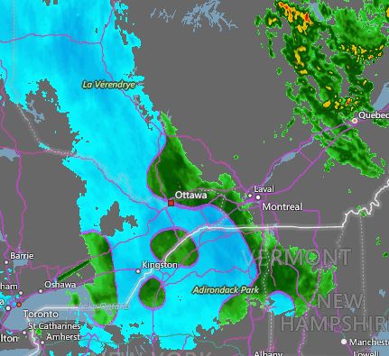
AccuWeather radar shows the precipitation changing from rain (green) to snow (blue) across eastern Ontario and the Ottawa Valley early Sunday morning. The snow will spread into Quebec later today.
Temperatures are dropping rapidly this morning in Montreal, behind a potent cold front. At 7:30 am, the temperature was 2C (36F) here on L'Ile Perrot, down from 7C (45F) at midnight. Rain has started this morning and will gradually change to wet snow this afternoon. The snow will persist into Monday, with accumulations of 5 to 10cm (2 to 4 inches) forecast for the city. Heavier snow and blowing snow is expected across eastern Ontario and far western Quebec, including the 401 corridor towards Kingston. These regions are under a snowfall warning through Monday. Accumulations in those areas, including Ottawa, will be in the 15 to 30cm (6 to 12 inch) range. Gusty northwest winds are already reaching 70km/h in southern Ontario, spreading into eastern Ontario and southern Quebec later today. Winds of 30 to 70km/h will persist into Monday afternoon.

Low pressure located over northeast Ontario will move into central Quebec today. A second area of low pressure is currently developing over southern New England and will lift into eastern Quebec. Abundant moisture, along with cold northwest winds, will produce snow over the entire region. The snow will not taper off until late Monday. The temperature will fall to -2C (29F) tonight and rise only to 0C (32F) on Monday. The Monday-morning commute will be challenging in Montreal, to say the least. Give yourself plenty of extra time.

Saturday, November 19, 2016

Calm before the storm for southwestern Quebec

Blizzard conditions pounded sections of Minnesota and northwest Ontario on Friday. Numerous accidents were reported along with several fatalities from the first storm of the season. The snow arrives in Montreal by Monday. (KARE 11 Photo via Twitter)
Dense fog has developed once again this morning in Montreal. The fog is expected to dissipate by mid-morning allowing sunshine to warm temperatures to 13C (55F). The record high for November 19 is 16.7C set in 1953. We have an outside shot at this, if the wind can shift out of the northeast. On Friday, a northeast breeze resulted in a high of 9C (48F) in Montreal. At the same time, over a dozen locations in Ontario reported record highs, including Windsor at 21.6C (71F), eclipsing the record of 18.9C set in 1971.

We now shift our attention to the first winter storm of the season. Low pressure over northwest Ontario this morning is forecast to move eastward into western Quebec by Sunday. A strong cold front will sweep across the St. Lawrence Valley overnight with rain developing. Temperatures fall rapidly behind the front, with rain changing to snow in Ontario during Sunday and towards Montreal by Sunday night. A special weather statement is currently in effect for southern Quebec as well as eastern Ontario. South of the border, winter storm warnings are in effect for the St. Lawrence Valley of New York, as well as the Adirondacks and Green Mountains.

So what does all this mean? Basically we are looking at a 24 to 36 hour snowfall from late Sunday into Monday night for the entire region. Amounts will be based on elevation and how rapidly any location changes form rain to snow. At this time, the heaviest amounts are expected across the mountains of southern Quebec and New England. However, western regions of our forecast district, including Cornwall and the Seaway Valley, may see 10 to 15cm of snow by late Monday. I think Montreal will settle into the 5 to 10cm range. Temperatures will turn much colder, and strong northwest winds are forecast, a far cry from what we have been experiencing so far this fall.

Friday, November 18, 2016

Wild weather weekend for Montreal: from record warmth to snow

Dense fog slowed the Friday morning commute in Montreal. Several accidents were reported, as the visibility fell to under 0.5 kilometres. (Valley Weather Photo)
A large winter storm continues to develop over central Minnesota this morning. This system has produced snow from Colorado northeast into western Ontario. Heavy snow and strong winds are creating difficult travel conditions for a wide area of the northern plains and upper Midwest. In excess of 30cm (1 foot) of snow is forecast for Thunder Bay and the surrounding regions of western Ontario. The storm is forecast to move east into Ontario and Quebec over the weekend. On the east side of the system, in advance of the storm, warm air will surge northward into southern Quebec. High temperatures are forecast to be in the low-to-middle teens today and Saturday in Montreal. Thick fog is expected for both mornings. Once the fog burns off, expect a sunny and warm day, with near record-high temperatures for Montreal.

A sign of the seasons; The Denver metro area had a record high of 27C (80F) on Wednesday. Less than 36 hours later, snow fell, causing hazardous driving conditions and hundreds of accidents. (AccuWeather)
First Snowfall for Montreal
On Saturday night, a strong cold front, associated with the aforementioned winter storm, will slide across eastern Ontario and into the St. Lawrence Valley. A period of steady rain is expected into Sunday, along with rapidly dropping temperatures and increasing northwest winds. By Sunday night, temperatures will approach the freezing point, with rain changing to snow in Montreal and southern Quebec. Snow is forecast, in varying intensities, through Monday morning. At this time, accumulations are very difficult to pinpoint, due to the warm weather in advance of the snow. However, expect a dusting up to as much as 10cm (4 inches) in some locations by Monday. Roads may be snow-covered and slippery, so prepare now for winter driving during the Monday morning commute. I will update this situation later today and over the weekend via The Suburban Twitter feed and Facebook page as well as at valleyweather.blogspot.com

Thursday, November 17, 2016

First snowflakes of the season expected in Montreal

Snowy commute on L'Ile Perrot, November 24, 2015. This could easily be the scene by Monday morning. Much colder weather and the chance of some snow is expected by the end of the weekend and next week. Get your snow tires on now.
Roughly in-line with 2015, the first snow of the season is forecast for Montreal by the end of the upcoming weekend. Before we reach that point, very mild air will surge northward into Ontario and Quebec to end this week. Clearing skies today will allow for moderating high temperatures to 10C (50F). Clear skies are expected overnight for the entire area, along with patchy fog. The forecast low will be either side of 0C (32F) in metro Montreal. Friday and early Saturday will be breezy and very mild, with high temperatures approaching the low teens. The record high for both Friday and Saturday in Montreal is 16.7C (62F) set back in 1953. We may have an outside shot at that Saturday, depending on how much sunshine we receive. This is where the good weather news comes to an end.

Install your snow tires NOW
Strengthening low pressure is expected to move from North Dakota into the western Great Lakes by Friday. This storm will provide the first blizzard of the season for portions of the western Great Lakes, upper Midwest and western Ontario. Strong winds will combine with 20cm (8 inches) of snow, to provide very poor travel weather along the Trans Canada Highway either side of Thunder Bay, Ontario by Friday morning. As this storm pulls east, a strong cold front will sweep across southern Quebec late Saturday. Temperatures will plummet from near record highs Saturday, as the coldest air of the season arrives. Daytime temperatures on Sunday in Montreal will actually fall most of the day. Overnight lows by Monday morning may be as cold as -5C (23F), with daytime highs on both Monday and Tuesday near 1C (33F). There is also a good chance rain will develop late Saturday and mix with snow by Sunday evening into Monday. Accumulations are difficult to pinpoint at this time, but expect slippery driving conditions early next week. Looking ahead into the middle and late portion of next week, the weather will remain cold in southern Quebec, with another chance of rain and snow by Thursday.

First snowflakes of the year expected in Montreal

Snowy commute on L'Ile Perrot, November 24, 2015. This could easily be the scene by Monday morning. Much colder weather and the chance of some snow is expected by the end of the weekend and next week. Get your snow tires on now.
Roughly inline with 2015, the first snow of the season is forecast for Montreal by the end of the upcoming weekend. Before we reach that point, very mild air will surge northward into Ontario and Quebec to end this week. Clearing skies today will allow for moderating high temperatures to 10C (50F). Clear skies are expected overnight for the entire area, along with patchy fog. The forecast low will be either side of 0C (32F) in metro Montreal. Friday and early Saturday will be breezy and very mild, with high temperatures approaching the low teens. The record high for both Friday and Saturday in Montreal is 16.7C (62F) set back in 1953. We may have an outside shot at that Saturday, depending on how much sunshine we receive. This is where the good weather news comes to an end.

Install your snow tires NOW
Strengthening low pressure is expected to move from North Dakota into the western Great Lakes by Friday. This storm will provide the first blizzard of the season for portions of the western Great Lakes, upper Midwest and western Ontario. Strong winds will combine with 20cm (8 inches) of snow to provide very poor travel weather along the Trans Canada Highway either side of Thunder Bay, Ontario by Friday morning. As this storm pulls east, a strong cold front will sweep across southern Quebec late Saturday. Temperatures will plummet from near record highs Saturday, as the coldest air of the season arrives. Daytime temperatures on Sunday in Montreal will actually fall most of the day. Overnight lows by Monday morning may be as cold as -5C (23F), with daytime highs on both Monday and Tuesday near 1C (33F). There is also a good chance rain will develop late Saturday and mix with snow by Sunday evening into Monday. Accumulations are difficult to pinpoint at this time, but expect slippery driving conditions early next week. Looking ahead into the middle and late portion of next week, the weather will remain cold in southern Quebec, with another chance of rain and snow by Thursday.

Monday, November 14, 2016

Mild and unsettled week ahead for southern Quebec

A rather weak coastal storm will produce clouds and much-needed rainfall for New England and portions of Quebec by late Tuesday. (AccuWeather)
High pressure remains in control of the weather across southern Quebec and eastern Ontario this morning. Gusty southwest winds continue today, as they have for the entire weekend. The wind has made the daytime temperatures feel slightly cooler, but also kept the overnight lows well above normal. I recorded an overnight low of 7.6C (46F) here on L'Ile Perrot, the normal low should be -2C (29F). Sunshine will be abundant today, along with a mild high of 12C (54F). Normally, we should reach only 6C (43F) for November 14. Winds should ease off a little, into the 20 to 30km/h range.

We have a rather active weather pattern on the horizon for the region. As mentioned, the week starts off nearly perfect, with widespread sunshine and mild temperatures. These conditions will persist into early Tuesday, before clouds begin to thicken. Low pressure developing along the east coast of the US will spread clouds and showers westward into southern Quebec late Tuesday and Wednesday. I don't expect a big rainfall event for Montreal, but it will be cloudy and showery through early Thursday. Temperatures will remain above normal for the week.

Skies will clear out by Friday, before the next weather system begins to impact southern Quebec into the weekend. The next storm will be much stronger and more typical of November. This low will develop over Colorado and move northeast into the central Great Lakes. Gusty southerly winds ahead of the storm will produce very warm weather for eastern Canada and the US. Even stronger winds on the backside of the storm will pull down the coldest air of the season so far into the northern plains. Clouds will increase next Saturday, with rain possibly changing to snow in some places by late Sunday. In advance of the storm, temperatures will be very warm Friday and Saturday in Montreal, but plummet on Sunday. This storm will bring the first major snowstorm of the season to the northern plains, southern Prairies and western Great Lakes into Friday. Heavy snow and near blizzard conditions are possible in North Dakota and southern Manitoba, including Winnipeg, by Thursday night.

Friday, November 11, 2016

Lest We Forget


Please take time on this November 11, to remember all those who have paid the supreme sacrifice to give us the freedom to live the way we do today. Without these brave men and women, Canada would be a very different place. Thank you.

Thursday, November 10, 2016

Strong winds, colder temperatures to end week in Montreal

The setting sun reflects off a yellow maple on L'Ile Perrot Wednesday afternoon. The cold nights have forced the yellow maples to drop their leaves in bunches this week. Strong winds over the next 24 to 36 hours in Montreal should take care of most of the remaining leaves. (ValleyWeather Photo)
As far as November goes in Montreal, this second week has been rather spectacular. Sunshine and mild temperatures have prevailed during the daylight hours, with clear, cold nights. The trend appears to continue into the upcoming weekend and beyond, albeit with a little hiccup. A strong cold front is poised to cross the St. Lawrence Valley Thursday evening, ushering in the coldest air so far this fall. The cold will not last long, as temperatures begin to moderate by Sunday. Sunshine today will veil behind increasing clouds as the afternoon moves along. Temperatures will be rather mild, reaching 11C to 13C (52 to 55F) across the region. Winds will become rather strong today, gusting over 60km/h out of the southwest in the St. Lawrence Valley.

By evening, a few showers are possible, along with dropping temperatures as the front moves through. On Friday, we can expect windy and much colder conditions, with scattered flurries across eastern Ontario and southern Quebec. Winds will be strong once again, in excess of 50km/h, this time out of the northwest. Temperatures will remain steady, around 3C (38F). Skies will clear on Friday night, with the coldest night of the season so far expected. Lows bottom out around -6C (21F) by Saturday morning. The good news for the weekend is that high pressure will be in control, with sunshine and warming temperatures, 5C (41F) Saturday and 11C (52F) Sunday.

The next chance for rain will come on Tuesday. At this time,
no unseasonably cold air or snow is on the horizon for Montreal, through at least the middle of November.

Today is the anniversary of the sinking of the Edmund Fitzgerald in 1975. You can read about this by clicking on the link on the upper left side of the page.

Strong winds - colder temperatures to end week in Montreal

The setting sun reflects off a yellow maple on L'Ile Perrot Wednesday afternoon. The cold nights have forced the yellow maples to drop their leaves in bunches this week. Strong winds over the next 24 to 36 hours in Montreal, should take care of of most of the remaining leaves. (ValleyWeather Photo)
As far as November goes in Montreal, the opening week has been rather spectacular. Sunshine and mild temperatures have prevailed during the daylight hours, with clear, cold nights. The trend looks to continue into the upcoming weekend and beyond, albeit with a little hiccup. A strong cold front is poised to cross the St. Lawrence Valley Thursday evening, ushering in the coldest air so far this fall. The cold will not last long as temperatures begin to moderate by Sunday. Sunshine today will veil behind increasing clouds as the afternoon moves along. Temperatures will be rather mild, reaching 11C to 13C (52 to 55F) across the region. Winds will become rather strong today, gusting over 60km/h out of the southwest in the St. Lawrence Valley.

By evening a few showers are possible along with dropping temperatures as the front moves through. On Friday we can expect windy and much colder conditions, with scattered flurries across eastern Ontario and southern Quebec. Winds will be strong once again, in excess of 50km/h, this time out of the northwest. Temperatures will remain steady around 3C (38F). Skies will clear on Friday night with the coldest night of the season so far expected, lows bottom out around -6C (21F) by Saturday morning. The good news for the weekend is that high pressure will be in control, with sunshine and warming temperatures, 5C (41F) Saturday, and 11C (52F) Sunday.

The next chance for rain will come on Tuesday. At this time,
no real cold air or snow is on the horizon for Montreal, through at least the middle of November.

Today is the anniversary of the sinking of the Edmund Fitzgerald in 1975. You can read about this by clicking on the link on the upper left side of the page.

Monday, November 07, 2016

Sunshine makes a welcome return to Montreal

Very cold air will surge into southern Quebec next weekend. Snow flurries are likely, even in Montreal. (AccuWeather)
November is often the darkest month of the year. The cold, damp, unstable fall nights often lead to cloud cover developing shortly after sunrise. This, combined with the change of the clocks, makes November seem dark and dismal. The sun will set today in Montreal at 4:34pm. Thankfully, high pressure will crest over southern Quebec and Ontario for the next 24 hours, with abundant sunshine and warming temperatures. We start the week with a hard freeze in Montreal, and early Monday morning temperatures of -4C (26F) in the city. As mentioned, sunshine today will allow a warming trend, up to 10C (50F). Clear skies will prevail tonight, along with much warmer lows of 5C (41F). Tuesday will be the best day of the week; expect sunshine and warm high temperatures near 15C (59F). A cold front will produce showers from late Tuesday night through Wednesday morning, along with cooler temperatures.

As we look ahead to the upcoming weekend, a strong cold front will usher in the lowest temperatures of the season so far. Overnight lows will drop well below freezing in eastern Ontario and southern Quebec, as cold as -6C (21F) by Sunday morning. In addition to the cold, snow flurries are possible, and even some accumulating lake effect snow closer to the Great Lakes. The forecast will need some fine-tuning as we get closer, but expect the coldest weekend of the season so far.

Thursday, November 03, 2016

Cooler weather returns to Montreal to end the week

Much colder air will pour in behind the rain by late Thursday. Some snow flurries are possible by early Friday morning in Quebec and northern New England. (AccuWeather)
Partial sunshine and southwest winds helped drive the temperature up to 15C (59F) in Montreal on Wednesday. It was a welcome return after days of thick clouds and cold, damp northeast winds. Sadly, it won't last. Late fall is a difficult time for prolonged sunshine, as the long nights tend to produce increased humidity levels, helping cloud cover to form during the day, as the atmosphere becomes unstable. Clouds have increased Thursday morning in southern Quebec, and the rain is not far behind. Low pressure will slide along a frontal boundary located across New England today. Rain will develop this morning and persist into the late afternoon. Temperatures will start the day rather mild, around 10C (50F) before the precipitation begins. A cold front will cross the St. Lawrence Valley this evening, with much colder air arriving behind it. Overnight lows will drop close to 0C by morning, with even a few flurries possible in some locations.

Friday will feature more clouds than sun in southern Quebec, along with brisk northwest winds and much colder temperatures of 5C (41F) for Montreal. The weekend is expected to be mostly cloudy, with perhaps a few showers late Saturday. While I expect dry conditions most of the time this weekend, sunshine will be at a premium. Temperatures will be slightly milder Saturday, near 9C (49F), before colder air returns Sunday at 6C (43F). Depending on which extended forecast you believe, the start of November at this time, does look milder than normal.

Monday, October 31, 2016

Perfect Halloween forecast for Montreal and eastern Ontario

First Responders patrol the streets in Notre-Dame-de-L'Ile Perrot last Halloween. They do so each year to ensure the safety of our children. The weather will be perfect tonight, so please slow down and be extra careful while driving among the trick or treaters. Have fun and be safe. (ValleyWX Photo)
Perfect Halloween weather is in the forecast for Trick or Treating in Montreal tonight. Temperatures will be around 4C (39F) at 6pm. Enjoy the evening and be safe.

I am back on this Halloween Monday, with a near perfect forecast for southern Quebec. Friday was miserable, with a cold rain in Montreal, and plenty of wet snow north and east of the city. After a dismal weekend of clouds, drizzle and gusty cold winds, sunshine will return today, with a seasonable high of 6C (43F). High pressure will be in control through the overnight hours and early Tuesday. It will be chilly tonight, with a low temperature around -1C (30F). Tuesday will start off sunny, before an advancing warm front thickens the clouds. The temperature will be much warmer, in the lower teens. A few showers are possible late Tuesday. Wednesday will be partly cloudy and warm for November, with the temperature reaching a very mild 15C (59F). A strong cold front will bring clouds, rain and dropping temperatures by Thursday.

Briefly looking ahead, the first two weeks of November are expected to be near normal. Beyond that, much colder weather is forecast, with the likelihood of the first snow in Montreal. Now is the time to prepare your car before the snow flies. Ignore the December 15 deadline for winter tires here in Quebec, in my opinion, that is just too late.

Tuesday, October 25, 2016

Cold rain and snow for southern Quebec and Ontario

Despite days of strong 40 to 60km/h west winds, some decent foliage still remains on the trees in Montreal and L'Ile Perrot. (Valley Weather Photo)
Stubborn low pressure continued to meander over eastern Quebec on Tuesday afternoon. Blustery northwest winds, along with frequent clouds and even some light showers or flurries, prevailed in Montreal. This is the same system that dumped over 100mm (4 inches) of rain on metro Montreal, along with as much as 60cm (2 feet) of snow across the highest elevations of the eastern Townships, Vermont and New York. The rain and snow produced flooding and power outages, especially across the Townships.

A warm front will produce rain and wet snow in southern Quebec and eastern Ontario late Thursday. (AccuWeather)
High pressure will finally nudge into the region overnight, with Wednesday being the best day of the week. Temperatures will be chilly tonight, below freezing in most locations. The low in Montreal is forecast around -2C (29F). Wednesday will be partly sunny, along with cool temperatures of 6C (43F). On Thursday, clouds will thicken as the next low pressure area moves from the Midwest into the lower Great Lakes. A warm front will approach Montreal, accompanied by light rain mixed with snow. Little accumulation is expected in Montreal at this time. Temperatures will continue below normal into this weekend. More rain is expected on the weekend, but the good thing is that Halloween looks dry and a touch milder.

Sunday, October 23, 2016

Windy much colder week ahead

The heavy rain that fell in southern Quebec since Thursday, has produced plenty of standing water on area roads. (ValleyWX)
Strong low pressure is moving into the Gulf of St. Lawrence this morning after providing the region with another dose of heavy rain on Saturday. This storm was the second in as many days to impact Montreal, eastern Ontario and southern Quebec. Heavy, wind driven rain occurred late Saturday, adding to the already impressive three day storm totals. More rain fell in Montreal in 24 hours than in the entire month of September (31.2mm). I measured 90.4mm as of 7am this morning here on L'Ile Perrot. Trudeau Airport recorded 88.6mm, St Anicet 94mm, Cornwall, Ontario 91mm, Kemptville, Ontario 79.7mm and Ottawa 55mm. The rain changed to wet snow across portions of upstate New York, Vermont and along the Quebec, New Hampshire border overnight. Reports this morning indicate anywhere between 5 and 20cm (2-8 inches) of wet snow. Snow was also reported Sunday morning in Sherbrooke and Quebec City.

Heavy wet snow fell overnight along the New Hampshire, Quebec border. This photo is from Stewartstown, New Hampshire, located 30km southeast of Coaticook on the US/Canadian border. Photo Credit: Kerry Motiejaitis via Twitter from WMUR meteorologist Josh Judge.
The weather is a raw and windy this morning in Montreal, with west winds gusting over 70km/h. Those strong winds will be with us for the next 24 hours. Expect unsettled weather this week, with some sunny breaks, but frequent clouds. There is the possibility of scattered showers or even some flurries at times. Temperatures will be below normal, with highs near 8C (47F) and lows around 2C (36F). By the end of the upcoming week, another storm system will bring us more rain.

Thursday, October 20, 2016

Fall storm to impact Montreal

The European forecast model of accumulated precipitation through Sunday for eastern North America; Montreal and southern Quebec are looking at the potential for 100mm of rain. (AccuWeather - click to make map larger)
Heavy Rain Warning: Posted for the St. Lawrence Valley of Ontario and Quebec, including metro Montreal. 

Heavy rain is forecast in Montreal over the next 48 hours, as strong low pressure moves from the Ohio Valley into southern Quebec this weekend. Rain is forecast to develop by mid-day Thursday and become heavy at times into the overnight hours. The rain will persist throughout Friday. At this time, computer models are indicating 50 to 100mm (2 to 4 inches) of rain for our region. Strong winds will also develop on Friday, as the storm system pulls off to our north and east. The wind will accelerate leaves falling off the trees making driving slick and clogging drains and sewers.

In addition to the increase in wind, temperatures will begin to drop. High temperatures will be near 14C (56F) today, but lower to only the single digits by late Saturday and Sunday. There is even the chance of some wet snow in both Ottawa and Montreal by late Saturday night or early Sunday. No accumulations are expected in the valley. Snow may, however, accumulate several centimetres well north of Montreal, as well as across the mountains of the Eastern Townships and northern New England. The cool, damp weather will persist into early next week.

If that was not enough, forecasters are watching an area of disturbed weather northeast of the Bahamas on Thursday morning. The system has the potential to develop into a tropical or sub-tropical storm over the next 48 hours. If it does develop, it would be named Otto. In any event, this system will pump Atlantic moisture into the northern storm, enhancing the rainfall across portions of Quebec and Atlantic Canada by late in the weekend.

Tuesday, October 18, 2016

Record warmth followed by mountain snow

Much colder air will bring us back to reality this weekend. (AccuWeather.com)
Record warmth surged into upstate New York, eastern Ontario and southern Quebec on Tuesday. The temperature reached 28.2C (83F) in Saint-Anicet, surpassing the previous record of 26.4C set in 1998. Saint-Anicet, located less than 75km southwest of Montreal, was the warmest location in Canada today. Sainte-Clotilde, just south of Montreal, reached 28C as well. Saint-Hubert posted a record 24C (76F), smashing the old record of 18.8C (65F) set in 2007. The high temperature at my home on L'Ile Perrot, reached just before 4pm, was 26C (79F). Trudeau Airport settled for 24.2C (76F), just short of the record of 25C (77F) set in 1968.

SNOW
A weak cold front will cross the area this evening, accompanied by showers and perhaps some thunder. Weak high pressure will provide Montreal with sunny and cooler weather for Wednesday. Expect highs to be near 16C (61F). Strong low pressure is forecast to develop Thursday across the Ohio Valley, and move into southern Quebec by Friday. Clouds will thicken early Thursday, followed by an extended period of rain through Saturday. The rain could be heavy at times, with the possibility of more than 50mm falling. As the system pulls to our east, cold air will wrap around the backside of the storm on strong northwest winds. The coldest air of the season will arrive in southern Quebec, with highs no better than 8C (47F) this weekend, and overnight lows close to the freezing point. Some snow is possible over the higher elevation of New York and Vermont, as well as the Townships and Laurentians. It is also quite possible that 10-20cm of snow could fall between Jay Peak and Mount Mansfield in the Green Mountains, late Saturday and Sunday. Some snow may occur northeast of Montreal. A few wet snowflakes may even fall in the St. Lawrence Valley Saturday night. Warnings may be needed as the event draws closer.

Monday, October 17, 2016

Warm, windy, wet week ahead for southern Quebec

The frontal rain predicted for late Sunday arrived a few hours earlier and put a damper on outdoor activities to end the weekend. Close to 13mm (0.5 inches) of rain fell in Montreal. Despite the clouds and rain, temperatures remained warm. The high on Sunday was 18C (65F), while the normal high/low should be 12/3C. As the cold front clears southern Quebec this morning, look for sunshine to develop along with mild temperatures, highs near 16C (60F). A warm front will lift north into the St. Lawrence Valley tonight, with clouds increasing near sunset. Showers with perhaps a rumble of thunder, are expected to develop after midnight. Temperatures will again be mild, near 10C (50F). Tuesday will be an unseasonably warm and windy day, with high temperatures into the middle 20's, depending on how much sunshine develops. Gusty southwest winds will exceed 50km/h in Montreal. Cooler unsettled weather is forecast by the end of this week, with more October-like temperatures dropping into the single digits, and perhaps a decent amount of rain by Friday and Saturday.

A large tree lies across a home in southern BC, after 100km/h wind gusts hit the region from Friday through Sunday. (TWN/Twitter Abbotsford Police)
Stormy West
While it has been rather quite and mild in eastern Canada, the west has been stormy and, in some cases, snowy. Several October snowstorms have impacted Alberta and Saskatchewan. Heavy snow fell last Friday in Edmonton, resulting in numerous accidents from unprepared drivers. Amounts ranged from 10-20cm across central Alberta. On the B.C. coast, strong winds gusted over 100km/h, producing pounding surf and toppling trees and power lines. Widespread damage was reported from southern B.C. into Washington and Oregon. A total of three storms knocked out power to over 200,000 B.C. homes. Ferries were cancelled and at least one fatality was reported. Between 100 and 300mm of rain has fallen during the three-storm event.

Friday, October 14, 2016

Frosty start to the weekend in Montreal, then warmer

Montreal continues to have a very warm and dry fall, despite the recent showers. On Thursday, 4 to 7mm of rain fell in the region, along a brisk cold front, bringing the monthly total to 19.6mm here on L'Ile Perrot. That amount is less than 50 percent of the normal for the month of October, a trend that has been persistent all year. Temperatures have also been quite mild. However, we did manage our first frost of the year this week. I recorded my first sub-zero temperature of the season here on L'Ile Perrot Friday morning at -1C (31F). A decent frost occurred as well, at least in my neighbourhood.

Strong high pressure will move into the region today and crest over New England this weekend. Conditions will be sunny through Sunday in Montreal, with high temperatures near 12C (54F) today. The temperature will warm into the upper teens and even low 20's by Sunday. Another cold front will bring the chance of showers Sunday night into Monday. Looking ahead to next week, the same pattern remains in place, with warmer-than-normal temperatures and just a chance of light precipitation early in the week and again by Friday.

A spectacular NASA image of Hurricane Nicole approaching tiny Bermuda on Thursday. (NASA Goddard MODIS Rapid Response Team Image)
Hurricane Nicole
Powerful hurricane Nicole became one of only seven such storms to pass within 40 miles of Bermuda since 1851. The tiny island was dwarfed by the massive storm on Thursday. Winds gusted in excess of 120mph, with widespread damage reported. Roofs were torn from homes, power poles were snapped, and flooding was reported. Power is out to most of the island. Thankfully no fatalities have been reported thus far.

Tuesday, October 11, 2016

Matthew's misery spreads from Haiti to Newfoundland

Heavy rain produced widespread flooding in Newfoundland and Nova Scotia on Thanksgiving Day. Above is a street in Sydney on Monday afternoon. (TWN/@redbatgirl)
Hurricane Matthew's parting shot at North America occurred Monday, as a moisture-fueled front dumped several months worth of rain in one day on Nova Scotia and Newfoundland. A state of emergency has been declared in several portions of both provinces, after 100 to 225mm of rain fell in 24 hours. Halifax reported 102.8mm, Eskansoni 199.3mm and Sydney 224.8mm. In Newfoundland, 180mm fell at Burgeo. The torrential rain produced widespread flooding of homes and businesses, as well as the collapse of several roads. Schools are flooded in many cases and, as a result, closed today.

Matthew moved into South Carolina on Saturday, before exiting the coast Sunday and merging with a cold front along the east coast. The front drew moisture north into New England and Atlantic Canada.

In Fayetteville, the North Carolina National Guard preforms a water rescue, one of thousands in that state. (@NCNationalGuard)
The death toll from Matthew is approaching 1000, including 23 in the US. Of those, nearly half occurred in North Carolina, where a combination of surge and fresh water flooding has produced catastrophic damage. On the Outer Banks, a record storm surge washed away roads and homes. In Fayetteville, firefighters and the National Guard were forced to perform thousands of water rescues. Power outages continue for hundreds of thousands of residents from Florida to Atlantic Canada. Matthew has produced an estimated $6 billion in damages in the US alone. In Haiti, residents are trying to piece together what little they have left, with relief agencies making a desperate plea for help. Thousands are homeless, with over 900 dead from Matthew. There are now fears of a cholera outbreak in the wake of the storm.

Saturday, October 08, 2016

Hurricane Matthew crawls into the Carolinas

Happy Thanksgiving! Smoke Meat Pete on L'Ile Perrot decorated for the season during Friday's spectacular weather. (ValleyWeather Photo)
Hurricane Matthew has been the focus of my columns this past week, and as a result I have been a little negligent on the home front. I have a preoccupation with hurricanes that goes back decades. Despite the rain this morning in southern Quebec, our weather continues to be warm and dry. Rainfall since late August is running at less than 50 percent of the normal. Temperatures have continued to be well above normal, including 25C (77F) on Friday. A cold front today is producing showers that will continue into Saturday afternoon. Noticeably cooler air arrives for Sunday and Thanksgiving Day, with temperatures closer to the normal high/low of 14C and 4C.

Twitter@JimCantore

Damage was extensive from Hurricane Matthew in the Daytona Beach area as well as northeast Florida. (TWC/AP Photo)
Hurricane Matthew
Hurricane Matthew's death toll continues to rise sharply with each passing hour. The storm is responsible for over 900 fatalities as of Saturday morning, including 4 in the US. Hard hit Haiti is reeling from torrential rains and mudslides, after a direct hit from Matthew. Florida has reported significant damage, especially along the northeast coast. The eye of the storm remained offshore this morning, but a tremendous surge of water has produced record flooding in some coastal locations. This morning a weakening Matthew, with 85 mph winds, is located 20 miles southeast of Charleston, South Carolina. The storm surge continues to be the big story, with 5 to 7 feet of water flowing into the South Carolina coast. Surge flooding and torrential rains will move into North Carolina as the day progresses. Over 1 million southeast US residents are without power this morning. Numerous coastal roads including the A1A in Daytona Beach, have been heavily damaged. South Florida escaped the worst of the storm.

One last check of the beach, before the storm surge inundated the coast at Jacksonville, Florida (AP Photo)

Thursday, October 06, 2016

Millions evacuate Florida's east coast ahead of Matthew

NOAA Satellite image of Hurricane Matthew, 215 miles southeast of the Florida coast Thursday morning.
Hurricane Matthew has been pounding the Bahamas for over 24 hours now. The center of the strengthening hurricane is located 215 miles (350km) southeast of West Palm Beach, Florida this morning. Millions of residents have been ordered to evacuate the coast, from Miami northward toward Jacksonville and beyond into Georgia and South Carolina. A hurricane warning is in effect, with the center of Matthew forecast to skirt the coastline through late Friday. Winds in excess of 125mph can be expected along Florida's east coast starting this evening. Heavy rain and a storm surge in excess of five feet are also expected along the southeast US coast.

Hurricane Matthew is currently a Category 3 storm, but forecast to strengthen to a Category 4 storm as it approaches Florida late today. Overnight winds gusted to 145mph in the Bahamas. Already this morning, Matthew is looking better organized on radar and satellite, with a deepening pressure to 939mb in the center of the storm. If Matthew comes ashore, it will be the first major hurricane to make landfall in the US since Wilma in 2005.

Damage from Matthew has been extensive in Cuba and Haiti. At least 27 fatalities have been reported across the Caribbean. Many portions of Haiti remain isolated, with flooding and no communications. Residents in coastal communities up and down Florida's east coast spent much of Wednesday boarding up, stocking up on supplies, and heading inland. A state of emergency has been declared in numerous coastal counties from Florida to North Carolina. Matthew is expected to linger along the coast during the upcoming weekend, before weakening and looping into the Atlantic, east of South Carolina.

Wednesday, October 05, 2016

Next up for hurricane Matthew: Florida and The Bahamas

Flooding is being reported today in Nassau, Bahamas, well ahead of Hurricane Matthew. (TWC/AP Photo)
Hurricane Matthew continues to be a very dangerous hurricane Wednesday afternoon. The center of Matthew is located 165km (105 miles) south of Long Island in the Bahamas. The storm is responsible for at least 11 fatalities in Haiti and Cuba, with that number expected to rise. Many locations in far western Haiti have reported widespread destruction. Homes were levelled in many villages, with major flooding reported and bridges washed out. Communications are down and thousands are homeless in the poorest country in the Western Hemisphere.

Hurricane warnings are in effect across the Bahamas, as well as the east coast of Florida, inland to central portions of the sunshine state. Evacuations have been ordered in many coastal communities from Florida to the Carolinas. Forecasters expect Matthew, currently a Category 3 storm with 120mph winds, to strengthen once again this afternoon. Matthew is expected to move through the Bahamas today and tonight, and along the Florida coast late Thursday. By Friday, the storm is expected to loop out into the Atlantic, east of South Carolina. Earlier forecasts had the storm moving up the entire east coast into Nova Scotia and Quebec this weekend. Current models are painting a much different scenario today, having the storm slow down and even move back towards Florida. Matthew will need to be monitored very closely by all east coast residents over the next few days. A state of emergency has been declared in several coastal counties from Florida to South Carolina. There has been a rush on water, gas, generators, batteries and anything else deemed useful to ride out this powerful storm.

Tuesday, October 04, 2016

Hurricane Matthew making landfall in Haiti

NOAA satellite image of hurricane Matthew just prior to landfall in western Haiti Tuesday morning. The eye is visible in the center of the image, nearing Tiburon, Haiti.
Powerful hurricane Matthew is making landfall Tuesday morning near Tiburon in western Haiti. Matthew intensified overnight, with maximum sustained winds now of 145mph gusting to 185mph. The eye of the storm increased in diameter as well, allowing the hurricane to look quite impressive on satellite and radar images this morning. Matthew is the first Category 4 storm to make landfall in Haiti since Cleo in 1964. Cleo was responsible for 132 fatalities in Haiti. A weather station in coastal Haiti reported a wind gust to 107mph this morning before it stopped transmitting. Haiti Libre reports major coastal flooding from the storm surge, as well as mudslides. One fatality was reported so far.
Hurricane Matthew will continue to impact Haiti and Jamaica today, with hurricane conditions spreading north into Cuba tonight. Torrential rain over the region, in some cases in excess of 40 inches, is possible. Rain of this magnitude will likely liquify soils, producing widespread flooding and mudslides across Haiti into the Dominican Republic.

Matthew is forecast to move north and then northwest over the next few days. This will bring the center of this dangerous storm into the Bahamas Wednesday, and eventually towards coastal Florida and the Carolinas by late Thursday and Friday. A hurricane watch may be needed later today for a portion of the Florida coast, including the Keys. By this weekend, hurricane Matthew will be moving close to the New England coast, with perhaps direct impacts here in southern and eastern Quebec, as well as Atlantic Canada into Thanksgiving Day. Plenty has to happen before then, but all interests from Florida to Nova Scotia should monitor the progress of Matthew.  

Sunday, October 02, 2016

Powerful Hurricane Matthew heads north towards Jamaica

The view of Hurricane Matthew from inside the US Air Force C-130 Hurricane Hunter. (Twitter@53d_HHA)
Hurricane Matthew started a slow turn to the northwest Sunday morning. The 13th storm of this busy Atlantic hurricane season is also the strongest since Felix in 2007. On Saturday morning, Matthew attained the strongest Category 5 status, with 160mph winds. The storm has since settled back to 150mph winds, with gusts to 185mph, making it a Category 4 storm on the Saffir Simpson Hurricane Scale. Hurricane warnings have been posted for Jamaica, Haiti and eastern Cuba. A hurricane watch is in effect for the Bahamas. All interests up and down the east coast from Florida to Nova Scotia should monitor the track of Matthew during the upcoming week.

The National Hurricane Center forecast track of Hurricane Matthew through the southern Caribbean. (NHC)
On Sunday morning, a US Air Force C130 Hercules Hurricane Hunter aircraft reported the center of Matthew 315 miles (510km) south southeast of Kingston, Jamaica at 8:00 a.m. Matthew is moving northwest at 5mph. The storm is forecast to maintain a slow trip north, taking the center across western Haiti or eastern Jamaica and into eastern Cuba over the next 36 hours. Beyond then, the storm may impact the US coast late in the week. Preparations are being rushed to completion in Jamaica and Haiti. Along with the wind and storm surge, torrential rain is forecast; in some cases, over 20 inches (500mm) of rain is possible. This type of rainfall over the mountainous portions of Haiti has, in the past, resulted in deadly flash flooding and mudslides.

Friday, September 30, 2016

Major flooding in southwest Ontario and Michigan

A state of emergency has been declared in Essex County, Ontario after two days of torrential rain. (Windsor Star)
A stubborn upper-level low stalled over the Ohio Valley continues to pump deep moisture off the Great Lakes, across southwest Ontario and Michigan. On Thursday, more heavy rain fell across the area, with nearly 160mm in Tecumseh, south of Windsor. Officially, 85mm fell at Windsor Airport, with over 120mm in nearby Detroit. The normal rainfall for the entire month of September is 91mm in Windsor. The rain produced widespread flooding on roadways and in basements. Rivers are on the rise as well, with many exceeding flood stage. A state of emergency has been declared in Essex County, Ontario. More rain is forecast today, with another 50-75mm possible. Across the river in Detroit, the situation was much the same, with major highways closed and water rescues underway. The storm causing the rain will slowly drift southeast before lifting north again this weekend. Cloudy skies and showers are forecast across the Northeast, New England, southern Quebec and Ontario. The heaviest rain will remain south and west of Montreal.

Hurricane Matthew
Matthew strengthened into a hurricane on Thursday, with the center located 535 miles southeast of Kingston, Jamaica Friday morning at 5:00 a.m. Matthew is moving west at 14mph, with 100mph winds. Additional strengthening is expected today, and Matthew could become a major hurricane. The forecast track will take the system west for the next 36 hours before turning north towards Jamaica and Cuba by late Sunday. By the middle portion of next week, Matthew is forecast to be near the Bahamas. The storm may then threaten the east coast of the US and Canada, but it is too soon to determine where and to what extent. Additionally, the possibility does exist that the storm could be swept out to sea, missing the east coast.

Wednesday, September 28, 2016

September warmth to continue into October

A slow-moving upper-level low pressure area will persist across our region through the weekend. Montreal will remain on the edge of the system with frequent clouds and showers, but also some breaks.

According to the National Oceanic and Atmospheric Administration (NOAA), August was the 16th consecutive month with temperatures above average globally. This has not occurred over the last 137 years; basically, it has been exceptionally warm. August was 1.66F above the 20th Century average, eclipsing the record set just last year. The average temperature for 2016 to date is 1.82F above the long-term average. In Montreal, we experienced the second-warmest June-to-August period on record. The warmth continued into September. So far, the monthly average is 17.8C, above the normal of 15.5C. It has been extremely dry once again, with only 31.2mm of rain this month, compared to the normal of 83.1mm.

For the short term through the start of October, we are expecting temperatures to remain slightly above average. Stubborn low pressure will very slowly move from the central Great Lakes southeast towards southern New York. The system will then lift north again into eastern Ontario. Southern Quebec should remain on the periphery of the moisture, with showers forecast Saturday and Sunday, but not a washout. Gusty northeast winds will prevail through the end of the week as well, making it feel a little cooler than the advertised highs. Several mornings this week have featured a marine layer of clouds and fog generated by the northeast winds channeling down the St. Lawrence Valley.

Tropical Storm Matthew
Tropical storm Matthew has formed in the Atlantic Basin, 40km southwest of St. Lucia. Matthew is moving west at 20mph (31km/h), with 60mph (100km/h) winds. This storm is forecast to strengthen and become a hurricane by Friday. Forecasters then expect Matthew to turn to the north and impact Jamaica. Beyond then, there is the potential the storm could affect the Gulf Coast or even the eastern seaboard.

Thursday, September 22, 2016

Summer snow for Lake Louise, warm in Montreal

Heavy wet snow greeted visitors to Lake Louise, Alberta on the last full day of summer. (Lake Louise Ski Resort Photo)
The last full day of summer was spectacular across southern Quebec and Ontario. Plentiful sunshine, gusty southwest winds and warm temperatures prevailed, with highs reaching 27C (80F) or better in many locations across southwestern Quebec. Humidity levels were elevated, making it feel more like mid-summer. Montreal should be around 20C (68F) for late September. While we were enjoying August-like weather here in the east, an upper-level low and cold northerly flow produced a widespread summer-snowfall across the foothills of Alberta. As much as 32cm fell across the higher elevations near Banff, with over 30cm at Sundre. A cold rain fell east of the foothills towards Calgary.

The coolest air so far this September will invade southern Quebec this weekend. (AccuWeather Graphic)
First Day of Autumn
Fall officially arrives at 10:21 a.m. Thursday morning, with cooler weather and clouds forecast to greet the season. Today will still feature above-normal temperatures in Montreal, just not as warm as it has been. Expect high temperatures in the low to middle 20s. A cold front will move from north to south across southern Quebec tonight and into New England on Friday. Expect a period of steady rain along the front, followed by gusty north winds and much colder temperatures. Highs on Friday will only be in the upper teens. High pressure will settle into Quebec Saturday and remain through Monday. The forecast will be cooler than normal for the first time this month. Highs on Saturday and Sunday will only be around 15C (59F), with lows down to 7C (45F) in the city, but much colder in outlying regions. Some locations may even see scattered frost early Sunday and Monday morning. Briefly looking ahead to next week, warmer weather will return, with temperatures once again surging above normal in Montreal.

Monday, September 19, 2016

Warm September continues across southern Quebec

Warm, muggy weather will dominate the east coast and southern Quebec once more this week. (AccuWeather)
The hot and dry summer across southern Quebec has stretched right into September. With two thirds of the month in the record books, the average high temperature has been a sweltering 24.3C (76F), the normal should be 20.6C (69F). To date 18 of the 19 days in September have featured above normal temperatures. This trend continues Monday morning, with Montreal at 9 a.m. reporting 21C (70F), the warmest location in the country. Partly sunny skies and humid conditions are forecast today through Wednesday, with high temperatures well above normal at 26C (79F). The normal high for September 19, should be 18C (65F) for Montreal. With the exception of a couple of nights, the overnight lows have been very mild as well, averaging 13.5C (55F), the normal should be 10.3C (50F).

There has been a slight improvement in the drought conditions in southern Quebec after the rainfall of late August. September however has been very dry once again, with only 23.4mm of precipitation so far. Montreal normally receives 83.1mm of rainfall for September. We have plenty of catching up to do. Showers and thunderstorms over the weekend missed Montreal, with only 3 or 4mm falling in the city. The next chance for rain will come along a cold front Thursday. Cooler, more seasonable weather is expected to arrive by next weekend. However it will be short lived, as the much warmer than normal Great Lakes continue to modify the cooler fall air as it moves southeast from northern Canada.