Thursday, August 29, 2024

Wettest August on record for the Montreal region

The longer nights and cooler mornings  have allowed some trees to begin showing their colours across Southern Quebec. Despite the forecast for a cool Labour Day weekend in Montreal, it looks like we are in for a warm and wet fall, just as the entire year has been. (Valley Weather Photo)

Powered by the remains of tropical storm Debby, Montreal has added another dubious weather record to the books, the wettest August dating back to 1871. With just a few days left in August and meteorological summer, Trudeau Airport sits at 229.3mm of precipitation, just over 10 inches of rainfall for the month. The previous benchmark was 224.8mm set in 2011. We will add to the record on Saturday, with another 10-20mm of rain forecast before we say goodbye to one soggy summer.

The total rainfall for the three summer months is also a record for the city, currently at 450mm. That of course is at the airport in Dorval, as many already know, amounts are much higher in other parts of the city. For example, I have measured 484.2mm here on Ile Perrot. 

Many are still paying the price for the abundant rainfall as municipalities struggle to pick up the tons of debris leftover form the flooding caused by both Beryl and Debby. The wait for insurance adjusters and contractors has been long, and many homeowners are facing the likelihood of not being covered or being under insured for the damage. Many are dealing with the health impacts caused by moldy basements, not to mention the overall stress of the event. 

With summer coming to an end, we are getting a brief glimpse of what fall may look like. For the short-term, Montreal will be cool and dry for a day or two. High pressure will give us a sunny and cool Thursday at 21C (70F), followed by slightly warmer temperatures Friday, 25C (77F). Rain arrives on Saturday, with showers and thunderstorms persisting into Sunday. Skies will clear out for holiday Monday, with a chilly high near 18C (65F).

Beyond that we can expect a period of dry weather and warming temperatures next week. The general outlook from both Environment Canada and the National Weather Service for our region, is for above normal temperatures and precipitation during the fall months of September through November.

Wednesday, August 21, 2024

An early taste of fall weather for southern Quebec

Another rainbow in the skies over Montreal as our wet summer continues. Skies will begin to slowly clear on Thursday, with a return to more summer-like temperatures this weekend as highs rise into the middle and upper 20s. (Valley Weather Photo)

Our super wet summer persists across southern Quebec, with another 25-50mm of rain falling on the region since Monday. The culprit this time, a potent upper level low that is slowly drifting across the region with showers, thunderstorms and unseasonably cold temperatures. It has provided Montreal with a very early taste of fall weather. I have even seen a hint of colour in some of the trees as the days begin to shorten.

The high temperature failed to reach 21C (70F) in Montreal on Tuesday afternoon, the first time since June 10. We are sitting at a very cool and wet 14C (56F) as I write this blog Wednesday morning, and temperatures will not budge too much today. Adding to the fall-like feel will be rounds of rain, some of it rather heavy at times across southwestern Quebec and eastern Ontario. Another 15-25mm of rain is quite possible today, with highs struggling to reach 16C (60F), well-below the normal high of 24C (76F).

Since Monday, 47mm of rain has fallen at my home on Ile Perrot, with my monthly total now sitting at 233.8mm and counting. Slightly less at Trudeau, with 196mm, owing to the fact the airport received less rain during tropical storm Debby on August 9. The all-time record for the entire month of August is 224.8mm set in 2011. While many parts of the city, including here on Ile Perrot have already surpassed that amount, we will have to see if it is officially broken at the airport.

Expect one more cold and wet day Wednesday, before the upper level low slides to the east, and high pressure begins to move in. That will allow for pleasant weather beginning Thursday afternoon and lasting though the weekend. We can also expect temperatures to rise into the middle and eventually upper 20s by Sunday, as summer weather returns. The next chance for showers and thunderstorms won't be until Monday. 

Sunday, August 18, 2024

More heavy rain expected across southern Quebec

Laval, Québec on Friday August 9. More rounds of showers and thunderstorms are possible on Sunday, with 30-40mm falling on already saturated ground across the Montreal region. The summer of 2024 is quickly becoming know as the summer of the flood. Major flash flooding has now occurred on two separate occasions in both Toronto and Montreal as well as across Vermont and New York. (Association des Pompiers de Laval)

Special Weather Statement in effect for southern Quebec and eastern Ontario for 30-40mm of rain from Sunday afternoon into Monday morning. Some flooding and water accumulation is possible, especially in low-lying areas.

A common scene this summer in central Canada. This time is was Mississauga, Ontario on Saturday. (TWN)

Low pressure and a frontal boundary will slowly move across southern Quebec over the next 36 hours, generating showers and thunderstorms. Some of the showers will be slow moving, and capable of producing heavy rain. This will not be like tropical storm Debby on August 9. The storms will be scattered in nature and the hope is that the rain will spread out and not concentrated. However the ground is saturated in southern Quebec and waterways are full, so any additional rainfall is not welcome at this time.

Showers will be possible through Wednesday of the upcoming week, along with much cooler temperatures by Tuesday.

The summer of 2024 is quickly becoming known as the summer of the flood across eastern Canada. For the second time this summer, as with Montreal, the GTA experienced major flooding on Saturday. The culprit is an upper level low slowly moving across the Great Lakes and heading for southern Quebec. On Saturday, the low developed rounds of thunderstorms that moved off Lake Ontario and into the Toronto region dumping 128.3mm of rain at Pearson Airport. 

Toronto has now had its wettest summer on record, with 475.8mm falling, smashing the 2008 record of 396mm. Montreal is not far behind, with 415.8mm since June 1st at Trudeau Airport. There has been even more precipitation at other locations across southern Quebec. The trend will persist with more rounds of storms expected today and showers through the middle portion of the week.

The storms also generated a tornado with significant damage near the communities of Drumbo and Ayr in southwestern Ontario. The damage will investigated today by the Northern Tornadoes Project from Western University to determine the rating.

Thursday, August 15, 2024

More rain and thunderstorms for flood weary Montreal

After all the flooding in Montreal last weekend, it was nice to see the sun this week. Unfortunately the airmass is quite warm and humid, and has produced isolated thunderstorms. There has also been some smoke and haze from western wildfires.

Severe Thunderstorm Watch in effect for metro Montreal.

We have a risk of isolated strong thunderstorms Thursday afternoon, with heavy rain, hail and gusty winds possible through sunset.

The clean up continues in Montreal after the historic rainstorm last week associated with tropical storm Debby. Highway 13 finally reopened Thursday morning, after being closed to flooding and a damaged pumping station since last Friday night.

Environment Canada map displaying the accumulated rainfall across our region from tropical storm Debby. The heaviest rainfall, between 150-200mm (6-8 inches), locally more, was centered in the St. Lawrence Valley, and particularly the West Island, Ile Perrot and Vaudreuil.

Montreal has been under a warm and humid airmass this week, with frequent afternoon and evening thunderstorms across the southern portion of the province. The good news is that the storms have been widely scattered and have occurred in areas that received slightly less rainfall from Debby.

Montreal will remain in an unsettled weather pattern through at least next Monday. Primarily we will be affected by the departing upper level low to the east of our region, with scattered storms moving from north to south. As with any thunderstorms, heavy rain is possible, but it will not impact the entire island as Debby did. Temperatures will be quite warm Thursday through Saturday, rising to near 30C (86F) as it did Wednesday afternoon.

Over the weekend, we have another Great Lakes low pressure and associated frontal boundary expected to slide across southern Quebec. Showers and scattered thunderstorms are likely each day, with the possibility of 15-25mm of rain falling by Monday, perhaps more in thunderstorms. The hope is we avoid any additional flooding.

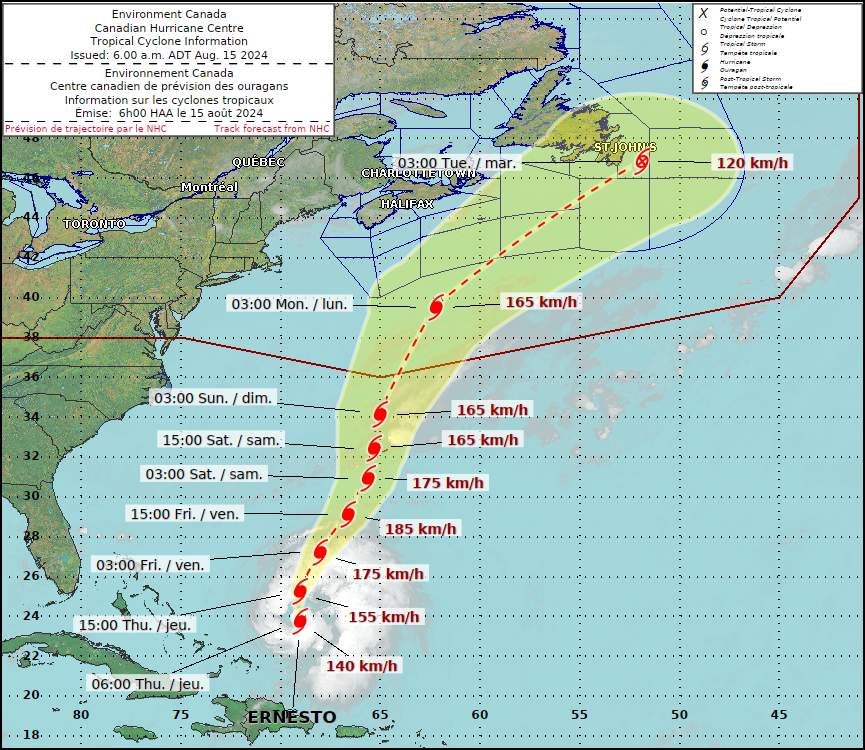
Hurricane Ernesto's forecast track will keep the storm far away from southwestern Quebec. The only Canadian location that will likely be impacted is Newfoundland. (ECCC)

HURRICANE ERNESTO

It is important to note that hurricane Ernesto will not impact the weather in southern Quebec as some were posting on social media Wednesday. The storm will be far out in the open waters of the North Atlantic.

Ernesto strengthened into a hurricane Thursday morning, 915 km southwest of Bermuda with 140km/h winds. The storm was moving north at 22km/h. A hurricane warning is in effect for Bermuda, with the centre expected to pass close to the island nation Saturday as a major hurricane. The storm will produce dangerous surf all along the US coast and into Atlantic Canada. Ernesto may brush Nova Scotia, but most likely will affect southeastern Newfoundland sometime next week. 

Friday, August 09, 2024

Tropical Storm Debby hammers Montreal with historic rainfall

The service roads and ramps off Highway 40 at Cote-Vertu were once again closed this morning due to major flooding. The roads were closed during the evening commute as well, as more heavy rain hit the city. In all between 100-175mm of rain fell in Montreal Friday, an historic amount of rain for one day. (Photo: Oliver Sutton)

A spectacular rainbow has just appeared in the eastern sky here on Ile Perrot after an historic weather day. Tropical Storm Debby dumped two months worth of rain on the region in just a few hours. At my home on Ile Perrot, 175.8mm (6.9 inches) of rain since the pre-dawn hours. This is the most rain I have ever recorded at any location I have lived in in the 48 years I have been observing the weather.

A remarkable 105mm of that total fell between 4pm and 8pm. Normal rainfall for August is just over 94mm. The rainfall today crushed both the daily record of 76.2mm set in 1917 and the monthly record for August set on the 29th back in 1893.

Highway 40 was once again closed Friday evening due to flooding. (Transport Quebec)

The result was as expected, numerous highways and ramps were closed during the morning commute creating gridlock, once again focused around our office at Cote Vertu. Our building flooded again, as it did back in July during Hurricane Beryl. Many drivers were once again stranded as their vehicles became inundated with water. Some of the same roads have been closed by Transport Québec again this evening due to significant water accumulation.

The rain that hit the city late Friday was even heavier, with more highway closures, including the Decarie Expressway.

On top of the heavy rainfall, winds gusted close to 80km/h at Trudeau Airport as the final heavy rain pulled across the region. The result has been widespread power outages to over 120,000 Quebec homes and businesses.

The good news is the rain is now over for Ile Perrot, with the back edge pulling across the city as I write. If the rain has not ended in your location, it will soon. Saturday should be sunny and dry, allowing many to assess the damage and begin the cleanup process. Once again insurance adjusters will be busy.

Debby brings major flooding to parts of Montreal

Major flooding has closed the ramps off Highway 40 at Cote-Vertu. Nearly 65mm of rain fell early Friday morning in Montreal, with more on the way. Photo: Oliver Sutton

Heavy rainfall warning in effect for southern Quebec. Rainfall totals may exceed to 100mm.

The first wave of precipitation has delivered major flooding to parts of the Montreal region Friday morning. Nearly 65mm of rain fell from the remains of hurricane Debby, flooding much of the same area affected by Beryl last month.

Sections of Highway 40, including ramps and service roads were closed at Highway 13 and Cote-Vertu. The result was traffic chaos during the morning commute. If you can work from home today do so. More rain is on the way this afternoon, and totals should easily surpass the all-time August record for the city 85.3mm, set on August 29, 1893.

Several homes and businesses have also been flooded this morning. There are sections of road closed, including Highway 40. 

Waves of tropical moisture will drop heavy rain across the city, with more flash flooding possible.

This story will be updated.

Thursday, August 08, 2024

Widespread heavy rain warnings posted for southern Quebec and Ontario

Tropical storm Debby made another landfall in South Carolina early Thursday morning. The storm center was located 100km west of Myrtle Beach, moving northwest at 11km/h. The remains of Debby will move into New York State on Friday, bringing heavy rain to Montreal. (Photo: Stephen B. Morton)

Heavy rain warning has been issued for southern Quebec and eastern Ontario including metro Montreal for 50-100mm of rain tonight through Saturday morning. Flood Watch for upstate New York including the St. Lawrence Valley.

The remains of tropical storm Debby will impact southern Quebec and Ontario starting Friday. A swath of deep tropical moisture will set up to the north and west of the track of Debby, interacting with a cold front pushing southeast across Ontario. Rain will begin late Thursday evening and persist through Friday. The rain will be heavy at times, along with embedded thunderstorms.

Forecast amounts are expected to be in the 50-100mm range (2-4 inches). Where the heaviest rain falls will be determined by the final track of Debby, expected to lift north from South Carolina towards Lake Champlain by Saturday morning.

The Canadian Hurricane Centre forecast track of tropical storm Debby from coastal South Carolina northeast across our region and into Atlantic Canada.

The various models have the heaviest rain falling along the St. Lawrence Valley, but scenarios range from right along the International Border to locations far northwest of Montreal across the lower Laurentians and Ottawa Valley.

The expected accumulations of rain are cable of producing local flash flooding, similar to what we experienced during Hurricane Beryl in July. Aside from the heavy rain, we can expect gusty winds, up to 50km/h along with very muggy conditions in the tropical airmass.

Conditions should improve on Saturday, but the airmass will remain unstable, with a risk of scattered showers into Sunday.

Debby made landfall along the Florida Gulf Coast on Monday as a category 1 hurricane. The storm was located 100km west northwest of Myrtle beach early Thursday morning. Debby has weakened to a tropical storm, with 75km/h winds. The storm will move slowly inland today, before increasing in forward speed towards the northeast this evening and Friday. Debby is already responsible for hundreds of millions of dollars in damages as well as six fatalities across the southeastern US.

Wednesday, August 07, 2024

Tropical storm Debby to impact southern Quebec

Flash flooding in Charleston, South Carolina, after tropical storm Debby produced over 300mm of rain on Tuesday. Debby is expected to bring heavy rain to Montreal by Friday. (Photo: Henry Taylor) 

Special Weather Statement issued for Montreal, for heavy rainfall in association with the remains of tropical storm Debby, expected by Friday.

Tropical storm Debby, located in the Atlantic Ocean, 85km southeast of Charleston, South Carolina at 11am Wednesday morning, is slowly meandering northeast at 7km/h. The storm has brought historic flooding to portions of northern Florida, southeast Georgia and South Carolina since late Sunday. Hundreds of thousands of homes and businesses were left without power after the storm made landfall in the Big Bend region of Florida early Monday morning.

Since Monday, Debby has been slowly moving across Georgia and is now back over the open waters of the Atlantic. Debby has strengthened a little Wednesday morning, with winds of 95km/h (60 MPH). Debby should make landfall in South Carolina later this evening before moving off towards the northeast into the middle Atlantic states.

The latest forecast track for tropical storm Debby, has the system passing southeast of Montreal early Saturday morning. Heavy rain, up to 100mm is possible across our region, but that may change as the event draws closer. Flash flooding is possible across a wide area from the US southeast into eastern Quebec. (NHC)

Significant rainfall, in some cases over 500mm (20 inches) is occurring across portions of the US southeast. This has resulted in significant fresh water flooding. The flood threat will spread all along the path of Debby into the Northeast, New England and eventually southern Quebec. Regions along the storm track can expect 50-200mm (2-8 icnhes) locally.

Debby is forecast to merge with a frontal boundary by Friday as the depression moves across northern New England to lie near Lake Champlain by early Saturday morning. The strom will then move into southern Quebec.

At this time we expect a swath of heavy rain across southern Quebec and eastern Ontario, including the metro Montreal region. It is too early to determine exact amounts, but the region could possibly see 50-100mm (2-4 inches) of rain between Friday morning and Saturday evening. Additional showers are expected into Sunday. The final track of Debby will determine where the heaviest rain occurs.

Many parts of New England and extreme southern Quebec have already experienced a very wet June and July. There has been significant flash flooding in parts of Vermont this summer, so any additional rain will only add to the saturated ground. 

Weather watches and warnings may be required as the event draws closer. Until then enjoy the spectacular weather Wednesday and Thursday in Montreal, with sunshine and high temperatures in the upper 20s.

Monday, August 05, 2024

Hurricane Debby pounds Florida Gulf Coast

Hurricane Debby produced significant fresh water and surge flooding in Florida on Sunday, including at Fort Myers beach shown above. (Photo: Andrew West)

Historic rainfall expected...

Hurricane Debby moved inland Monday morning across the Big Bend area of Florida's Gulf Coast. Debby reached hurricane status briefly overnight, with 80mph (129km/h) winds. Storm surge flooding started on Sunday from Fort Myers Beach northwards across Tampa Bay, Cedar Key and points north. A storm surge of up to 10 feet were observed at many locations, with coastal infrastructure and roads under water.

As Debby moved inland near Steinhatchee, Florida, strong winds and isolated tornadoes cut power to over 275,000 Florida homes and businesses. Power outages and wind damage are now spreading northward into southern Georgia.

At 8am Monday morning, Debby was located about 95km north, northwest of Cedar Key, very close to Horseshoe Beach, where winds gusted to 95mph (152km/h). Debby was moving north, northeast at 17km/h, with a central pressure of 979mb.

Hurricane Debby is expected to weaken to a tropical storm while meandering across the southeastern US for most of the upcoming week. The slow movement of the storm is expected to produce historic rainfall and catastrophic flooding across Georgia and the Carolinas. (NHC)

As Debby moves inland, the system is expected to weaken to a tropical storm. But wind will not be the big story with Debby, it will be the rainfall. Torrential, tropical rainfall is forecast all along the storms track from Georgia into the Carolinas. Rainfall of 200mm (8 inches) to as much as 500mm (20 inches) is expected. Catastrophic to historic flooding is anticipated in many parts of north Georgia and southeast South Carolina. 

Debby is expected to move into the Atlantic briefly Tuesday before a second landfall in South Carolina. Debby is expected to slow down considerably, meandering across the region for the better part of the upcoming week. The remains of the system will spread clouds and rainfall northward into waterlogged New England and perhaps even southern Quebec by next weekend. We will have a better handle on local impacts, if any, as the week progresses. For the time-being, the big story will be the life-threatening flooding expected across the southeastern United States.

Friday, August 02, 2024

Hot and humid weather persists across southern Quebec

The hot and humid weather during the past week across our region has been broken at times by occasional showers, thunderstorms and even rainbows!

Heat Warning in effect for southern Quebec

Widespread heat warnings and advisories are in place for much of southern Ontario and Quebec as well as a large part of the northern and central US, including both the Champlain and St. Lawrence Valley. The combination of very warm temperatures and high humidity will push humidex values into the upper 30s for many, with even a few 40C readings. Montreal managed a humidex reading of 40C (104F) on Wednesday afternoon. The current heatwave included an all-time record high of 35.9C (96.7F) at Gaspe Airport on July 29. This surpassed the previous all-time high of 34.8C (94.6F) set in 1983. Records at that locations date back to 1915.

It has been a very humid stretch of weather across most of eastern North America over the past week, with humidex values approaching 40C in Montreal. Over the past week, daytime highs have been at or over 30C (86F), with the exception of Wednesday, when clouds and thunderstorms managed to keep the high at 28C (83F). The trend will persist into the upcoming weekend, with highs near 32C (90F) Friday, and close to 30C both Saturday and Sunday.

The warm, humid airmass will generate a few isolated thunderstorms Friday afternoon, just as it did Thursday. However, most of the region will remain dry. Overnight, conditions will very warm and muggy, with some valley fog possible, and lows near 22C (72F). 

We an expect a very warm and humid weekend. A few weak low pressure troughs may generate some scattered showers and thunderstorms. That threat will increase Monday, as a stronger cold front arrives from Ontario. We can expect an increase in aerial coverage of showers and storms, with a increase chance of heavy rainfall. Cooler and finally some less-humid weather is expected by midweek next week.

It has been a very wet summer here in eastern Canada. Many region including Montreal, Toronto and especially parts of Vermont have been hit with significant flash flooding. In the case of northeast Vermont, some locations have had major flooding on more than one occasion. Rainfall totals for the July included 124mm at Trudeau Airport, with 215.4mm at Pearson Airport in Toronto.

I see no end in sight for our wet summer, especially with the expected increase in tropical activity during August and September. 

Thursday, July 25, 2024

Tornado confirmed in Brossard

A semi truck lies on it's side in Brossard on Wednesday evening, after a tornado moved across the area around 8:15PM. There was also damage reported to a few homes, power lines and trees. (Longueuil Police Photo)

The Northern Tornadoes Project from Western University will be investigating the damage caused by a tornado in South Shore Brossard around 8:15PM Wednesday evening. The storm was captured on video and appears to be an EF-0 tornado or perhaps a low end EF-1. Investigators will confirm the tornado and determine the strength later today. The tornado uprooted trees, knocked over a semi truck and cut power to over 3500 homes around Matte Boulevard. The same line of storms did show some rotation as it passed over my location on Ile Perrot. 

The same storm the produced the possible tornado in Brossard Wednesday evening, exhibited rotation as it moved across Ile Perrot around 8PM. (Valley Weather Photo)

Tow other possible tornadoes were observed in Saint-Hippolyte and Portneuf. If both storms are confirmed, it will bring the number of tornadoes to date in 2024 to 11 across Quebec. This is well-above the long-term average of 4.

As expected, strong thunderstorms swept across southern Quebec and parts of Ontario starting early Wednesday afternoon. The storms were in response to a frontal boundary moving into a very moist and unstable airmass. There were several rounds of storms into the evening hours, producing primarily heavy rain an lots of vivid lightning across the Montreal region.

Around 16mm of rain fell at Trudeau Airport on Wednesday, bringing our monthly total to 112.4mm. There was some minor flooding reported, especially in the western portion of the island, but thankfully not a repeat of the July 10 storms.

Thunderstorms produced some minor flooding along Senneville Road near the Île-aux-Tourtes-Bridge Wednesday afternoon. (Valley Weather Photo)

In Ontario, the storms prompted tornado warnings in the mid-afternoon for the Hawkesburry region and neighbouring Lachute. In the evening hours another tornado warned storm moved from the Rideau Lakes region into the Merrickville and Kemptville area south of Ottawa. There were reports of downed trees and power lines.

A cold front on Thursday will be accompanied by isolated showers, before cooler and less humid air arrives for Friday. Temperatures will be cooler Thursday and Friday, before warming once again into the high 20s and low 30s for the weekend and beyond.

Meanwhile western Canada is baking and burning. Temperatures soared to 40C (104F) across southern Saskatchewan and Alberta on Wednesday. Significant fires are burning in Alberta and British Columbia, including the Jasper Complex Fire that has burned thousands of hectares and forced the evacuation of Jasper Townsite and closure of the National Park.

Monday, July 22, 2024

Showery and humid weather week ahead for Montreal

The weather was perfect Sunday for the annual car show at Pointe-du-Moulin on Ile Perrot. There were hundreds of cars on display, including the 1958 Ford Thunderbird shown above. A huge turnout of spectators was present as well at the historic park along the shores of the St. Lawrence River. (Valley Weather Photo)

Another typical July weather week is set to unfold in Montreal. We just came off a nearly perfect weekend, with shower activity confined to the late evening and overnight period Saturday into Sunday. Both days were sunny and warm, with less humid and breezy conditions on Sunday making it an ideal day for any outdoor activity.

The week will start fair and warm, but clouds will increase on Tuesday, setting the stage for a few rounds of showers and thunderstorms through Thursday. Temperatures will be warm, around 28C (83F), and it will feel muggy as humidity levels begin to creep up. Rainfall amounts may exceed 25mm in the most persistent showers, that would likely be on Thursday. As the week draws to a close, skies will clear and temperatures will begin to rise. Expect daytime highs to rise into the low 30s by next Sunday as a heatwave returns to southern Quebec o end the month.

Another 4mm of rain fell Saturday night in Montreal, bringing our wet July up to 96mm at Trudeau Airport, however unofficially more has fallen around other parts of the city. I have measured 87.2mm for the month on Ile Perrot. While these amounts are impressive, they are nothing compared to Toronto's Pearson Airport, where a whopping 185.4mm, over 7 inches of rain has fallen in July. Ottawa has recorded 117.3mm.

They could sure use the rain across Western Canada. Widespread heat warnings are in effect as high temperatures soar into the middle 30s, in some cases exceeding 40C (104F) across interior B.C. The high heat has created extremely dangerous fire conditions across a wide portion of the western US and adjacent Canadian provinces. In British Columbia alone, there are 319 active fires burning, 32 in the last 24 hours and 198 declared in the last week. The hot weather is expected to persist throughout the upcoming week.

Wednesday, July 17, 2024

Flash flooding sweeps across southern Ontario

Close to 100mm of rain falling in just a few hours flooded large sections of the GTA Tuesday morning, including the Don Valley Parkway shown above. (Twitter Photo #ocstorm)

Just as it did last week in Montreal, severe thunderstorms produced widespread flash flooding across the greater Toronto region on Tuesday.

A cluster of thunderstorms developed along the Lake Ontario shoreline on Tuesday morning, hammering southern Ontario with rounds of heavy rain. Significant flash flooding occurred across the GTA, closing roads and inundating homes, businesses and even Union Station with deep water. 

Public transportation in several areas ground to a halt after 97.8mm of rain fell at Toronto's Pearson Airport, the fifth wettest day on record at that location. Most of that in just a few hours. TTC stations filled with water, and firefighters had to rescue commuters from Go Trains. A dozen motorists were also rescued from the badly flooded Don Valley Parkway. Toronto Hydro reported as many as 170,000 customers without power at the height of the storm. Many roads and ramps remained closed into Wednesday morning as the cleanup continued. It was Toronto's third "100-year flood" since 2013.

Damage will likely run into the tens of millions after major, widespread flooding occurred across the Toronto region on Tuesday, July 16. (Photo: OPP)

Significant flooding was also reported in the London region. The line of thunderstorms swept northeast towards Kingston before moving east into upstate New York and passing well south of Montréal. Severe weather was reported in New York and Vermont, with wind damage, power outages and more flooding.

Despite the hot and humid weather across southern Quebec, most of the storms were tame in nature, with lots of lightning, but just a few millimetres of rain here in the St. Lawrence Valley late Monday night and again Tuesday afternoon.

With the amount of cars badly flooded and likely destroyed as well as the amount of water that flowed into homes, train stations and businesses, damage will run into the tens of millions of dollars, just as it did here in Montréal last week.

Monday, July 15, 2024

More heat, humidity and thunderstorms

High humidity levels have produced hazy skies over Montreal since the flooding last Wednesday. Adding to the hazy skies has been high altitude smoke from wildfires burning in western Canada. Expect a few more days of hot and humid weather, along with scattered thunderstorms and the potential for more local flash flooding.

Typical July weather will persist across southern Quebec, as we remain on the northern edge of a very hot and humid airmass along the eastern seaboard and central portion of the United States. We can expect elevated humidity and temperatures near 30C (86F) through Wednesday. Humidex values will be close to 40C for many locations. 

Heat warnings have been issued for eastern Ontario, and heat advisories for the Champlain Valley of Vermont and New York. Regardless of the warnings, the weather will feel muggy and oppressive, so seek out A/C or a pool and drink plenty of fluids over the next few days.

There is a risk of pop up thunderstorms during the afternoon and evening hours, the greatest risk being Wednesday along a cold front. Any thunderstorm that develops in this type of airmass, has the potential to produce heavy rain and flash flooding. We experienced just how quickly flooding can happen in Montreal last week, with just 50 or 60mm of rain falling in an hour or two. Other than the rain, there is a risk for small hail and strong winds, even perhaps an isolated tornado away across the lower Laurentians and in the Eastern Townships.

July has been a warm month in Montreal, with 29C (85F), being the magic number. Trudeau Airport has reached 29C on 8 days this month, with 30C (86F) on three of the other days of the 15 so far. Humidity levels have been sweltering at times, with plenty of moisture around, as 89mm of rain has already fallen in July. As I write Monday morning, we are already sitting at 24C (76F), with a tropical dew point of 21C (70F), humidity reading of 83 percent and a humidex value of 33C (92F) at 8AM.

By Wednesday, cooler, less-humid air should arrive across southern Quebec as a cold front moves across the St. Lawrence Valley. Showers and thunderstorms will accompany the front into Thursday before skies clear for Friday and into next weekend.

Thursday, July 11, 2024

Beryl hammers southern Quebec and New England

Record-breaking rainfall from the remains of hurricane Beryl caused major flash flooding in Montreal during the Wednesday afternoon commute. The Decarie Expressway, shown above, flooding once again.

The rainfall warning remains in effect for Montreal through noon Thursday. Thunderstorms may produce another 15-25mm of rain today as the remains of Beryl become absorbed by an upper level low over eastern Ontario

The remains of hurricane Beryl, located in eastern Ontario early Thursday morning, hammered the Montreal region Wednesday afternoon, with a record-breaking 80mm of rain in just a few hours. The rain overwhelmed the sewer systems causing major flooding across the central portion of the city and specifically between the Decarie Expressway and Highway 13.

Highway 40 at Cote-Vertu (Photo: Regina Zorman)

At Trudeau Airport, 79.2mm of rain fell in a few hours, crushing the daily record of 32.5mm set in 1975. We fell just short of the all-time record for July of 87.6mm set in 1880. The event is definitely at the high end of rainstorms for the metro Montreal region.

Numerous roads were closed at the height of the rush hour creating absolute gridlock, and forcing the afternoon commute to last well into the late evening. Highway 40 was under water and Cote-Vertu, as was Cote-Vertu at Begin where several cars sat in water door deep in the intersection.

Many cars were inundated by flood waters and abandoned. The Montreal Fire Department carried out several water rescues. Damage was reported to several homes and businesses as basements flooded, including The Suburban's office building at 7575 Trans Canada. The building was evacuated by the fire department after water, several feet deep, entered the basement. Power was cut and remains out on Thursday.

Catastrophic flooding has occurred once again in central Vermont. Above, a destroyed home in Plainfield, Vermont. (Photo Anna Guber, WPTZ News)

The storm had far reaching effects, with major flooding reported in Vermont once again on the one year anniversary of the historic 2023 flood. Many of the same locations in central Vermont were hit hard. Homes have been damaged and roads washed out.

In New York, dozens of tornado warnings were issued, with three confirmed touch downs so far.

The heavy rain and severe weather occurred after Beryl interacted with a warm front over northern New York and a tropical airmass over southern Quebec. Unfortunately the warm and humid weather, with intervals of showers, will persist for Montreal well into next week.

Tuesday, July 09, 2024

Remains of Beryl to bring heavy rain to Ontario and Quebec

Tropical depression Beryl will lift northeast into the lower Great Lakes and eventually eastern Ontario on Thursday. Very heavy rain and thunderstorms will move into southern Ontario early Wednesday and spread into southern Quebec later in the afternoon. 50 to 100mm of rain is possible for many locations.

Special Weather Statement for metro Montreal.

Heavy Rain Warning for southern Quebec south of the St. Lawrence River as well as eastern Ontario

Flash Flood Watch for northern New York and Vermont

What is left of hurricane Beryl is moving across the Ohio Valley late Tuesday evening, expected to lift northeast into the Great Lakes on Wednesday. Along and to the north of the track of Beryl, heavy rain and training thunderstorms are expected, with flash flooding possible. 

Tuesday was warm and humid in Montreal, with another 30C (86F) high for the city. Humidex values were well into the middle 30s. A weak front pushed south across the St. Lawrence Valley late in the day with a few showers and will settle into New England before moving north as a warm front Wednesday. That front will become the focus for very heavy rainfall Wednesday as it lifts back north. Where the front sets up will determine who has the greatest flood threat. 

The thinking at this time is that the heaviest rain will fall along the St. Lawrence Valley in Ontario southeast into the Adirondacks of New York. Montreal will be on the northern edge of the heaviest rain, with 30-50mm (1-2 inches) possible. Any slight shift north would bring the flood threat into Montreal.

At present, heavy rain warnings are in effect along the St. Lawrence River and south to the US border. Amounts may exceed 50mm from late Wednesday into Thursday morning. The biggest threat for flash flooding looks like northern New York into Vermont, where 50-100mm (2-4 inches) is possible, with local amounts in excess of 150mm (6 inches) possible. This amount of water would produce flash, urban and river flooding.

Hurricane Beryl produced catastrophic damage as it made landfall near Matagorda Bay, Texas early Monday morning. Portions of the central and upper Texas coast reported significant storm surge flooding along with tornadoes. Above, surge flooding in Sargent, Texas. (Photo Mike's Weather Page)

Beryl's circulation has been producing flash flooding and isolated tornadoes across the Mississippi Valley on Tuesday, lifting northward into the Ohio Valley and Great Lakes. The death toll from Beryl in Texas and Louisiana has reached 7. On Tuesday, nearly 2 million residents along the Gulf Coast and in Houston remained without power in searing 100F heat.

Beryl should become absorbed into an upper level low and move southeast across the region Thursday. The showers will taper off, but conditions will remain warm and humid throughout the week and into next weekend.

Monday, July 08, 2024

Beryl moves inland over south Texas - expected to bring heavy rain to Ontario & Quebec

Radar image of hurricane beryl making landfall along the Texas coast in the pre-dawn hours Monday, July 8. (NOAA)

Early Monday morning a strengthening hurricane Beryl moved inland near Matagorda Bay on the central Texas coast. As of 7am. the hurricane was located 40 kilomteres southwest of Houston, moving north at 19km/h, with 120km/h winds. Beryl had been meandering in the Gulf of Mexico, a weakened storm after hitting the Yucatan region on Friday. Beryl was a category 5 hurricane as it struck parts of the Windward Islands.

As Beryl made landfall in Texas, a storm surge of 3-7 feet occurred along the coast near and to the right of the center. Winds gusted as high as 150km/h, producing widespread power outages along the central and upper Texas coast. Heavy rain is forecast to spread inland today, affecting the flood-prone Houston metropolitan region. In excess of 200mm of rain is possible at many locations. The heavy rain will spread north into Arkansas and Oklahoma as the day wears on. Tornadoes are possible as well across east Texas and Arkansas.

By Thursday morning, the remains of hurricane Beryl will be moving into southern Ontario. Very heavy rain, up to 100mm, is expected to fall along a narrow swath. That swath may line up along the St. Lawrence Valley and impact Montreal. The path will need to be watched closely. (NHC)

As Beryl is downgraded to a tropical storm later today and eventually a depression by tonight, the remains will move northeast into the Ohio Valley and Great Lakes. Beryl will become a big rainmaker as the circulation interacts with a warm front draped across northern New England.

The airmass is tropical in nature already, with elevated humidity levels. Some locations in southern Quebec and Ontario have already had considerable rainfall over the last week or so from thunderstorms. The ground is saturated in many locations, especially across the Eastern Townships and New England.

Very heavy rain is expected to develop Wednesday along with embedded thunderstorms. The atmosphere will be tropical in nature. At this time, most computer models have the heaviest rain falling over New England, but it will be dependant on where the warm front sets up. Some locations may recieve as much as 100mm (4 inches) of rain from Beryl.

Outside of Beryl, southern Quebec and Montreal can expect a warm and humid week, with scattered showers and thunderstorms.

Friday, July 05, 2024

Warm and humid weather to persist into the weekend - Beryl eyes Texas coast

The death toll across the Caribbean region has reach eight in the wake of Hurricane Beryl. The once category 5 storm levelled the Grenadian Island of Carriacou (above) with widespread, catastrophic damage. A weakening Beryl was located over the Yucatan region of Mexico on Friday afternoon, expected to move into the Gulf of Mexico later tonight and threaten the lower Texas coast by late Sunday. (Loop Caribbean News Photo)

Numerous temperature records for daytime highs and even overnight lows were established in June in Montreal and across parts of eastern Ontario and southern Quebec. That trend is persisting into July. We have had quite a warm and muggy start to the month, with daytime highs just shy of 30C each day at Trudeau Airport. Relative humidity levels have also been creeping up the last few days and conditions are rather uncomfortable Friday afternoon, with a humidex value 32C (90F) as I write this blog.

The upcoming weekend will follow the trend set so far this summer, with showers and thunderstorms expected. It will not be a washout however, with the main threat for precipitation overnight into the early morning hours Saturday, as well as later in the day. Temperatures will remain warm, in the high 20s through the weekend and into next week. 

After the passage of a cool front Sunday, slightly less humid air will be in place for Monday. However this will not last long, as moist air streams northward once again by mid-week. We will have to watch the oppressive heat and humidity that is building across the United States along both coasts to see how far north it moves. Temperatures across the Prairies, southern Alberta and interior British Columbia will rise into the 30s to near 40C in some cases this weekend and into next week.

The official National Hurricane Center forecast track for Beryl this weekend, taking the hurricane from the tourist region of the Yucatan Peninsula northwest into the lower Texas coast by late Sunday. Beryl remains a dangerous storm, with an elevated risk for surge and fresh water flooding for south Texas, spreading well inland. (NHC)

Hurricane Beryl

We will also need to monitor the remains of Hurricane Beryl as it moves inland over Texas by late Sunday. On Friday afternoon, Beryl was located inland over the Yucatan peninsula of Mexico, with 140km/h winds. The storm was moving to the west northwest at 26km/h with a central pressure of 980mb. The center was located 1095 kilometres east southeast of Brownsville, Texas. Beryl has been downgraded to a category 1 hurricane after pounding Jamaica and the Cayman Islands. As the center moves well inland over Mexico, it should weaken to a tropical storm before re-emerging back over the Gulf of Mexico early Saturday. Some intensification is now forecast before landfall along the Texas Gulf Coast by late Sunday or Monday.

Monday, July 01, 2024

Record-breaking hurricane Beryl slams Windward Islands

An image being shared on social media of significant damage on Grenada's Carriacou Island after the passage of Hurricane Beryl on Monday, July 1.

The Atlantic hurricane season is unfortunately off to the intense start many forecasters had feared. The first named hurricane of the season, Beryl, grew into a Category 4 monster today before racing across Grenada's Carriacou Island at around 11am EDT Monday morning. The storm maintained 150mph (240km/h) winds at landfall, making it the strongest hurricane since Ivan in 2004 to impact this region. NOAA Hurricane Hunters flying into the storm, reported a minimum barometric pressure of  946mb at 5pm Monday, with Beryl maintaining 150 mph winds. According to the National Hurricane Center, Beryl is the strongest June hurricane in the record books, as well as the earliest category 4 storm dating back to 1851.

Why is Beryl strong? Very simple, the Atlantic basin is currently as warm as it normally is in September at peak season for hurricanes. Hurricanes do not know what time of the year it is, but they do know warm waters. Basically, Beryl is acting like a September storm. This is just the start, with forecasters predicting a very active, intense season.

An enhanced NOAA satellite image of Hurricane Beryl making landfall on Carriacou Island at 11am EDT Monday, July 1st.

Reports from Grenada and the surrounding island are of widespread power outages and flooding. Initial reports from Carriacou Island are of significant damage and flooding. Social media mages form the island show numerous buildings without roofs as well as large boats submerged in the harbour.

Maurice Bishop International Airport in St. Georges, Grenada, reported winds early Monday afternoon of 92 mph, gusting to 121mph (148G194 km/h)

Beryl is now racing away from the Windward Islands at 21 mph (33km/h) towards the northwest. The storm is expected to remain a major hurricane through midweek while moving south of Haiti and Cuba and approaching Jamaica. Afterwards, wind shear is expected to increase in the vicinity of the hurricane, causing a gradual weakening as Beryl approaches the Yucatan Peninsula of Mexico.


Friday, June 28, 2024

Another wet summer weekend for Montreal

The weather has been highly changeable in Montreal this June, with frequent showers and thunderstorms, and impressive quantities of rainfall, including a record-setting 53.4mm falling in less than 24 hours on June 23. Another round of showers and thunderstorms is expected this weekend. (Valley Weather Photo)

Special Weather Statement issued by Environment Canada for southern Quebec, for heavy rainfall this weekend.

Our wet June continues, with another showery, humid weekend in the forecast for southern Quebec and eastern Ontario. Sadly it will be the third in a row. A fast moving west to east zonal flow has been responsible for the rapidly changing weather this month. We remain on the northern periphery of a large heat dome located across the southern and eastern United States that has been responsible for our brief but significant hot and humid stretches this month.

Montreal has had a real mixed bag of weather, with 7 days above 30C (86F) and over 122mm of rain to date. The normal is only 83.6mm. We will add to that rain total this Canada Day weekend, as a potent weather system moves across the region, bring periods of heavy showers and embedded thunderstorms, especially late Saturday into Sunday. Precipitation amounts are expected in the 20-40mm range, but may exceed 50mm in the most persistent thunderstorms. While this will bring our rainfall up to impressive levels for June, it is far from the record of  219mm set way back in 1922.

What the rain and muggy weather has accomplished other than disrupting outdoor activities, is it has lowered the fire risk across Quebec. To date according to SOPFEU, we have had 197 wildfires, well-below the 10 year average of 289.

As far as temperatures go, we had a very chilly morning Friday behind Thursday's windy cold front. The low here on Ile Perrot was only 8C (47F). The temperature will recover under the warm June sun to around 24C (75F) Friday. Expect muggy daytime highs around 25C (77F) bot Saturday and Sunday. Any sunshine both days will help increase temperatures as well as instability and lead to more active thunderstorms. The weather should improve for Canada Day Monday in Montreal, with a high of 25C (77F). Warm and humid weather will return by the middle of next week.