Tuesday, July 31, 2007

Tropical Depression Three
off East Coast
• Blazing Heat continues - spreads east
• A friend turns 200,000

• Just a few quick notes this wonderful July morning. The month is almost over. What started as a rainy and unseasonably cool month will end very hot for most of the country. This will be Ontario's hottest week of the year to date. High temperatures will be over 30C right into the weekend. Temps in the west have been close to 40C in Saskatchewan once again. A humidex reading of 53C was recorded in that province on the weekend, the warmest ever!

• This weekend the NASCAR Busch cars are in Montreal. I will be there, needless to say. The weather sunny and warm, awesome, thank you weather gods!
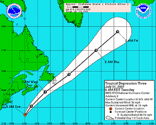
• The third tropical depression of the 2007 Atlantic Hurricane season has formed about 310 miles southeast of Massachusetts. As you can see on the map above the storm is expected to become Tropical Storm Chantal. it is forecast to skirt the Avalon off Newfoundland with gusty winds and heavy rain. The tropics are heating up, with forecasters watching several other waves developing. I imagine our quiet season to date is about to come to an end. Please stay away from the Outer Banks!

• An important friend of mine turned 200,000, kilometres that is, at exit 619 on the 401 on Thursday. My Saturn SL1, while not the 69 Charger I have always dreamed of, has taken me everywhere. It has not only taken me to and from the ones I love but has also proved a valuable friend in storm chasing, and it has the hail dents to prove it. Thank you Little Limo! My beautiful daughter below with the car in the background (red) in line for the Glenora fery, on our latest adventure to Sandbanks!

Monday, July 23, 2007

Close to 90mm of rain fell in Kemptville


Blazing Heat in Saskatchewan
Heavy Rain in Ontario
The rain of last week created havoc and flooding across parts of Eastern Ontario. Radar estimates and observations showed that as much as 150mm of rain fell in less than 24 hours, smashing records in places. Kemptville had over 90mm. Flooding was reported in area businesses. In the Renfrew area many fields were underwater with bales of hay floating away. Part of the embankment under the tracks on the Wakefield Steam Train line north of Ottawa were washed away.

In Saskatchewan it is the lack of rain and the blazing heat. A record and dangerous heatwave is underway in that province as well as Manitoba, the Dakotas and Montana. Temperatures soared to 38C in Val Marie, Saskatchewan yesterday and again today. Some place will reach 40C tomorrow. Only slight relief is on tap the middle part of the week with a stray shower or two, then back into the mid thirties to end the week.

Friday, July 20, 2007

Merrickville-Wolford - Kemptville
1:39 PM EDT Friday 20 July 2007
Rainfall warning for Merrickville-Wolford - Kemptville continued. Heavy downpours expected to continue this afternoon. An upper disturbance affecting eastern Ontario this afternoon will continue to produce heavy rain. Several localities have already reported amounts of 50 to 100 millimetres. Over 75mm in Kemptville. Additional local rain amounts up to 50 millimetres are possible. Visibility may be occasionally reduced in heavy downpours. Rain will taper to scattered showers in the next couple of hours for the City of Ottawa but linger until early this evening along the Seaway Valley.
Flooding on Prescott Street in Kemptville


Flooding Rains continue in Ontario
70mm since last night
Torrential rains continue to fall in Eastern Ontario at noon. The heavy rains are beginning to cause flooding in basements and businesses in the Kemptville area. Over 7cm (70mm or 3 inches!) of rain has fallen, most of that since 4am. The rain is filling ditches, and rivers are beginning to rise.
Pumps have been brought in the help the businesses on Prescott Street in Kemptville.
The system responsible is spinning in place over the 416 corridor and is continuing to dump heavy rain. Warnings remain in effect.


Totals to 10am:
LOCATION
TORONTO (DOWNTOWN) 62mm
TORONTO (DOWNSVIEW) 40
TORONTO (BURNHAMTHORPE) 48
APPLETON (SW OF OTTAWA) 63
BALACLAVA (NEAR RENFREW) 93
BARRIE 44
COBOURG 47
COLDWATER 100
COLLINGWOOD 49
DRUMMOND CENTRE 40 (N OF PERTH)
KEMPTVILLE 58 to 10am 12 more mm since
MUSKOKA 61
ORILLIA 106
OTTAWA 43 (AS OF 10 AM)
PETERBOROUGH 23
PETAWAWA 102
TRENTON 20
Over 60mm of rain has fallen in Kemptville in the past 24 hours


Heavy Rain and Flooding
If you built an arc, kudos to you. It has been raining heavily since about 4am in Kemptville. We have had 60mm in the past 24 hours most of that, about 40mm falling since 4am. The water is ponding on roadways and poor drainage areas and causing slick travel.


Heavy Rain Warnings are in effect for all of southeastern Ontario. The culprit is a slow moving upper low spinning over our area. There have even been embedded thunderstorms adding to the totals. The rain is falling in upstate New York as well where Flood Advisories have been posted for St. Lawrence County. The rain should taper off by noon, leaving an excellent weekend behind it.

Monday, July 16, 2007

More sun than rain east
Blazing heat west

The sun is shinning a little more these days in Ontario and Quebec, despite this however it remains cooler than normal. The normal high in Montreal and Ottawa should be 27C. So far this summer more than 75 per cent of the days have had some form of rainfall, be it showers or thunderstorms. There have been numerous reports of hail and severe weather as well, and just generally unsettled. Last night (Sunday, July 15) thunderstorms raced across the St. Lawrence Valley and into the Valleyfield area around 9pm, with spectacular lightning, hail and heavy rain.

This pattern will continue again this week in Ontario, at least till Friday. Temperatures will be in the mid-twenties, with the threat of showers each day.

The west is a much different story. A large ridge of high pressure building in from the desert southwest will push very hot air into parts of Alberta and Saskatchewan. Temperatures are expected to soar into the 30's and approach 40C by the weekend over Saskatchewan and Montana. Keep cool! Along the boundary of warm air, thunderstorms produced golf ball and baseball size hail in Alberta today.

The east will warm up into next week I believe. That is little comfort for those who have tried to camp, or swim on the five weekends so far this summer. Each one has sported below normal temperatures and rain. So far, next weekend looks good...keep your fingers and toes crossed!

Wednesday, July 11, 2007

Smiths Falls - Perth - Eastern Lanark County
12:34 PM EDT Wednesday 11 July 2007

Severe Thunderstorm Warning for Smiths Falls - Perth - Eastern Lanark County downgraded from tornado warning. A line of strong to severe thunderstorms is eastward across the above regions. Some of these storms contain damaging winds and large hail. Some of these storms could also produce tornadoes.
Smiths Falls - Perth - Eastern Lanark County
12:22 PM EDT Wednesday 11 July 2007

Tornado warning for Smiths Falls - Perth - Eastern Lanark County
A possible tornado is located between Renfrew and White Lake. This dangerous storm is moving eastward toward the Arnprior area.Please refer to the latest public forecasts for further details.Please refer to the latest public forecasts for further details.

It will be a dangerous couple of hours in Eastern Ontario. Stay alert, the front should pass by 3pm east of our area.

Tuesday, July 10, 2007

Tornado Warnings in Ontario

Supercell thunderstorms are developing in the very warm humid air across Ontario, Quebec and New York.

Keep and eye to the sky and check out the weather links on the left hand side.

Here is my weather column from the Iroquois Chieftain for this week...

More wicked severe summer weather developed again across Ontario this week. Two more tornadoes touched down just south of Walkerville. The tornadoes were part of a very impressive supercell thunderstorm that moved off Lake Huron towards Lake Erie. It lasted over 7 hours and produced hail and fierce straight line winds. Damage was limited to some farms with no injuries reported. In our area several thunderstorms popped up in the warm and humid air mass on Monday. The storms developed rapidly and moved south along a line from Winchester to Cardinal and east to Morrisburg. To show you just how fast these storms can surprise you on an otherwise fair day, within 30 minutes the storms had developed and moved south of the river into central New York. By the time warnings were issued the storms had passed out of our area. When the air is extremely unstable with high humidity and heat, thunderstorms are always possible. Learn how to spot them before they affect you and seek shelter, especially if you are on the open water, or the golf course.
The storms are part of the leading edge of very hot, searing heat that has been affecting the US and west. It was close to 40C in southwest Saskatchewan and southern Alberta late last week. Meanwhile triple digit Fahrenheit heat and record wildfires continue to affect the US West. Hundreds of thousands of acres are burning from South Dakota to California. One wildfire in Utah, is a killer, and is consuming at times, an astonishing 10,000 acres an hour.
We will continue to be on the edge of this heat with numerous weather systems bringing us bouts of hot followed by very cool weather and in between thunderstorms. This is typical Summer weather in our latitudes especially when we are on the fringe of the warm high pressure that is heating up the US.
For updates and important links to weather right here in the Seaway, visit my website at http://valleyweather.blogspot.com/

Monday, July 09, 2007


Above: A car is consumed by a landslide in Ottawa.
Below: Torn branches from severe weather near Walkerton

High risk of severe weather today

Severe Thunderstorm Watches have been posted for a wide area of upstate New York, Vermont, Southern Quebec and have been extended into Eastern Ontario. This morning a series of storms swept across the area with hail, high winds and heavy rain. These storms came on the heals of yesterday's storms that produced heavy rain and tornadoes in southwest Ontario. The heavy rain in the Ottawa area, over 20mm, contributed to a landslide that swept a car down a 25 metre embankment. No one was injured but 21 people were evacuated from nearby homes.

Environment Canada has confirmed that 2 tornadoes touched down in the farm country west of Walkerton, Ontario yesterday. Thousands are without power. The air remains sultry in the province with very high humidity and temperatures approaching 30C in many areas. The heat is spreading north from the US where a two week triple digit heatwave countinues, and is spreading to the east.


The risk is high for severe weather in our area today, stay alert.
Humidex readings will approach 40C.