Friday, August 31, 2018

Strong thunderstorms produce widespread power outages and an EF-2 tornado

The roof of a duplex in Saint-Leonard was peeled back by the strong thunderstorms Wednesday afternoon. (CTV News)
A fast moving line of strong thunderstorms swept across eastern Ontario and southern Quebec Wednesday afternoon. The storms were moving in excess of 50km/h, racing across the island of Montreal from west to east in less than 30 minutes. A wind gust of 93km/h was observed at Trudeau Airport as the front passed. Further east near Thetford Mines, an EF-2 tornado occurred in the rural region around Saint-Julien, with winds estimated between 180 and 220km/h. Accompanying the tornado was 50mm of rain and 2 to 4cm hail. Thousands of trees were flattened and a mobile home was destroyed. In eastern Ontario, a microburst with an estimated 170km/h wind gust, produced considerable damage to a farm north of Smiths Falls.

(CBC Photo)
In Montreal, numerous tees and branches fell as a result of the storm, several onto cars and hydro lines. A roof was peeled back from a duplex in Saint-Leonard. In the wake of the thunderstorms, Hydro Quebec reported over 170,000 homes and businesses without power in the province, most in metro Montreal and across the South Shore, West Island and Vaudreuil. The majority of clients had their power restored by Thursday morning.

The front ushered in much cooler and drier air, with a hint of fall in the air by Thursday morning. In Montreal the temperature fell from a high of 32C (89F) early Wednesday afternoon, down to 15C (59F) Thursday morning.

Warm and humid start to September
The cool, dry weather will be short-lived, as more heat and humidity will arrive across the Great Lakes and southern Quebec over the Labour Day weekend. There is a chance of showers and thunderstorms through Monday. High temperatures are expected in the upper 20s with humidex values in the middle 30s throughout long weekend. The warm weather is expected to prevail in Montreal through the first couple of weeks of September.

Wednesday, August 29, 2018

Elevated risk for strong thunderstorms Wednesday in southern Quebec

A strong cold front will bring an end to the current heatwave in Montreal. The storms should fire up this afternoon, impacting Montreal between 4pm and 8pm. (AccuWeather)
A Heat Warning remains in effect for southern Quebec for humidex values near 40C today.

A strong cold front will sweep across eastern Ontario and southern Quebec late today and into the wee hours of Thursday morning. Montreal has been entrenched in a soupy air mass this week, with high temperatures near 30C (86F) and oppressive humidity readings. Dew point temperatures, which are a strong indication of the amount of water vapour in the atmosphere, have been more Florida-like, in the middle 20s (70s F). Humidex readings exceeded 40C (104F) for over 4 hours in Montreal on Tuesday afternoon. Conditions would have been even warmer if it were not for several rounds of showers and thunderstorms.

Wednesday's cold front should arrive late this afternoon, with areas of strong thunderstorms developing in advance of the system. The most likely time for severe weather in Montreal, would be between 4pm and 8pm. The high temperature today will be near 30C. Any strong storms that do develop will have the potential to produce damaging winds and heavy rain. There is even a very slight risk of an isolated tornado north of metro Montreal. Keep in mind that with any scenario such as this, the storms are scattered in nature. While weather watches may be issued for a large area, the actual storms may only affect a small sector of the region. This is common with thunderstorm activity as we witnessed on Tuesday afternoon. They can pop up quickly, produce damaging winds and flooding rain and dissipate just as fast. Stay alert.

Cooler and much drier air will arrive on Thursday, with a daytime high of 23C (73F) and much lower humidity. Thursday night will be clear and refreshingly cool, with lows around 11C (52F).

Monday, August 27, 2018

Hot and humid return to school for students in Montreal

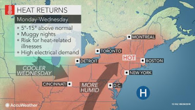
Hot and humid air will surge into Montreal and southern Quebec this week. Humidex values are expected to exceed 40C on Tuesday. (AccuWeather)
Environment Canada has posted yet another heat warning for southern Quebec through early Wednesday. The combination of heat and elevated humidity will make conditions feel oppressive over the next 48 hours. Humidex and heat index values will approach 40C (104F) Tuesday afternoon. The heat unfortunately will coincide with start of the new school year. Most schools do not have air conditioning, so it  will be uncomfortable to say the least. Temperatures are expected in the high 20s for Monday along with the risk of late day thunderstorms. Overnight Monday into Tuesday conditions will remain oppressive with lows in the low to middle 20s. On Tuesday, expect a breezy, hot day, with a daytime high of 32C (90F) in Montreal.

The hot weather will also extend into eastern Ontario, and south of the border across New York and New England. A heat advisory is in effect stateside for the St. Lawrence and Champlain Valleys. The late season heatwave will add to an already smoking hot summer. In the 84 days since the start of meteorological summer on  June 1, Montreal has exceeded 27C (80F) on 50 of those days. Included in that total are 15 days above 30C (86F).

Warm Fall
The late summer heatwave should come to an end on Wednesday, as a strong cold front ushers in cooler and dryer air. There is a chance of scattered severe thunderstorms on Wednesday for a portion of our region. With August drawing to a close, our attention will shift to fall. Current indications suggest a warm and dry September is on tap for southern Quebec. A weak El Nino is expected to develop through the fall and intensify into the winter months. If this scenario holds true, we may be looking at above normal temperatures through Christmas and into the new year.

Thursday, August 23, 2018

Powerful hurricane Lane heads for Hawaii

Hurricane Lane early Thursday morning, located 290 miles south of Honolulu. (NOAA)
A state of emergency is in effect across the Hawaiian Islands in advance of powerful hurricane Lane. On Thursday, Lane was located 275 miles (445 km) south of Honolulu, meandering northwest at 7 mph. Winds gusted over 130 mph in the center of the hurricane making it a Category 4 storm. Lane had weakened slightly, down from a rare Category 5 storm earlier in the week.


Further weakening is likely over the weekend, but Lane will remain a strong hurricane as it skirts along the eastern coast of the islands. Even if Lane does not make a direct landfall on the island chain, significant impacts are occurring and expected to persist into the weekend. Extremely heavy rain has already produced flash flooding and mudslides. Just Thursday alone, some locations on the Big Island reported over 20 inches (500 mm) of rain. The slow movement of the storm will only prolong the serious flood threat. Huge waves have been crashing along the south facing beaches, with heavy surf expected to spread further north on Friday. A storm surge of up to 4 feet is causing significant beach erosion. Evacuations have been ordered, along with the closure of schools and businesses.

Despite Hawaii's location in the middle of the central Pacific, it has not had a direct landfall from a hurricane in 26 years. In 1992, Category 4 Hurricane Iniki devastated the island state with a direct hit, producing 145mph winds and over $3 billion dollars in damage. Only two other storms have made a landfall in the satellite era, Dot in 1959 and Iwa in 1982.

Thursday, August 16, 2018

Heavy rain expected Friday in southern Quebec

While the storms missed Montreal on Wednesday, heavy rain fell along the northeast shoreline of Lake Ontario. The region around Kingston, Ontario was hit hard, with flash flooding reported. Between 25 and 90mm of rain fell across the region in just a few hours. (Global TV)
Many parts of southern Ontario, western New York and the northeast US have had a very wet summer. Wednesday was no different, as a cold front cut across the region, tapping into deep tropical moisture. The storms on Wednesday missed Montreal, but impacted the Kingston, Ontario region with flash flooding. Some neighbourhoods around Kingston reported 60 to 90mm of rain in a very short time. Numerous business and roads were flooded.

Further south in Pennsylvania and across the Mid-Atlantic US, the rain and storms have been relentless all summer. Streams and rivers are running very high, and serious flooding has already occurred, especially in Pennsylvania and New Jersey. In Wilkes-Barre and Scranton, over 100mm (4 inches) of rain fell on Monday alone. It was the most rain in a 24 hour period since Hurricane Connie in 1955. In the state capital of Harrisburg, 400mm (16") of rain fell during the month of July, the normal is 150mm (6 inches). At the same time, despite the oppressive humidity, parts of northeast New York, northern Vermont and Southern Quebec have been rather dry, with near drought conditions at times. Montreal has had close to 180mm (7 inches) of rain since June 1, but the majority of that has been very localized around Trudeau Airport, and occurred on just a few days. Rainfall to date in August is 33.6mm, the monthly 30-year average for the city is 94.1mm. On L'Ile Perrot, I have recorded 61mm since August 1, thanks to a few well placed thunderstorms.

Heavy rain and thunderstorms are forecast in Montreal on Friday. At this time forecasters are expecting 20 to 30mm rain.
Heavy Rain for southern Quebec
We will add to that monthly total on Friday, as low pressure over the Great Lakes combines with and advancing cold front to draw deep moisture northward from the Gulf of Mexico. The day will be very humid and unsettled, with heavy downpours and embedded thunderstorms likely. The showers will begin overnight in the Ottawa Valley and in the early morning hours in Montreal. The biggest threat for heavy rain in the St. Lawrence Valley will be in the afternoon. Rainfall accumulations could exceed 25mm (1 inch) in several locations. The storms should be fast moving, which should limit the risk of any flash flooding in metro Montreal. Skies should clear out early Saturday, setting the stage for a decent weekend, with just a slight risk of an isolated shower. Mostly sunny skies are forecast, with daytime high temperatures between 24 and 27C (75-80F).

Friday, August 10, 2018

Blazing hot summer across Canada from coast to coast

A spectacular photo taken in Orange County, California, as one of the worst fire seasons in recent memory continues across western North America.
The searing heat continues to impact large areas of Canada, with a focus on the west this weekend. A cold front moved through southern Quebec late Thursday, with isolated thunderstorms. A fast moving storm put down 15mm of rain in 20 minutes across Ile Perrot and Vaudreuil. The cold front brought in the coolest air of the month, with a morning low of 16C (61F) in Montreal. More importantly, the week long oppressive humidity finally broke as well.

The upcoming weekend will be warm once again, close to 30C (86F), but humidity levels should remain manageable. Sunshine will dominate in southern Quebec through Sunday evening, when our next chance for showers should arrive.

Dense smoke in B.C., has spread right across western Canada and into the northern US. (BC Wildfire Service Photo)
In Western Canada, hot high pressure is shattering records form B.C. to Saskatchewan. On Thursday, over 40 record high temperatures were established across the three provinces, including 40.8C (106F) at Kamloops, B.C. As I am writing this blog, temperatures once again are in the high 30s and low 40s across western Canada. Accompanying the heat has been dense smoke from forest fires burning across B.C. The smoke has lowered visibility from B.C. to western Ontario. Air quality alerts are in effect across western Canada, and southward into North Dakota, Montana and Minnesota.

In B.C. over 475 wildfires are burning, many being started from lightning strikes associated with dry thunderstorms. Rain is desperately needed. The high heat and extremely dry weather stretches from southern Canada to California, with thousands upon thousands of acres being consumed by fire. While Quebec and Ontario have been dealing with high humidity, dangerously low levels are being recorded out west, in many case lower than 10 percent.

Tuesday, August 07, 2018

Wicked thunderstorms cool off one hot city

Just one of the hundreds of lighting strikes over L'Ile Perrot late Monday afternoon. The atmosphere was charged with energy after a very hot and humid day that saw highs in the lows 30s and humidex values over 40C. (ValleyWeather Image)
The hot summer of 2018 has rolled into August, with little relief so far. On Monday, Montreal reached 31.7C (89F), the fifteenth 30C plus day so far this summer. Adding to the extreme heat was oppressive humidity levels, with the humidex over 40C (104F) for 6 consecutive hours on Monday. The blazing daytime heat and humidity was brought to an abrupt end around the supper hour, as a line of fast moving thunderstorms crossed the city. The storms affected my domain on L'Ile Perrot close to 6pm, turning day to night, with a vivid display of spectacular lightning. Winds gusted over 90km/h at several locations, and 82km/h at Trudeau Airport. A much needed 10-20mm of rain fell over a 30 minute period from Valleyfield to Dorval.

The combination of strong winds and lightning knocked out power to over 40,000 Hydro Quebec clients, most across the West Island, Monteregie and South Shore. As of 11am Tuesday, 5600 clients remain without power.

Looking ahead to the remainder of this week, we can expect less humid weather, but still warm and somewhat unsettled. There is a risk of more showers and isolated thunderstorms today and Wednesday, but the risk is slight. On Thursday, skies should clear along with dryer air. The temperature will remain above normal, as it has all summer in Montreal. Expect daytime highs from 26C to 30C (79F to 86F) with overnight lows a little more comfortable, between 16C and 20C (61F to 68F). Skies will be partly to mostly sunny from Thursday through Sunday.

Friday, August 03, 2018

Record hot July in Montreal - more of the same for August

A message many can relate to in parts of eastern Canada, is displayed on a business in French River, Ontario. The community, 500km west of Ottawa, is being threatened by the 27,000 hectare Parry Sound fire. Dense smoke has settled over many parts of northeast Ontario and western Quebec. (CBC)
The month of July is in the record books, and it was the hottest to date at Trudeau Airport. The average temperature at the airport in suburban Dorval was 24.2C, with data back to 1941. The only warmer month on record for the region was in 1921, downtown an McGill University, with an average of 24.7C. The long-term 30 year average for July is 21.2C. The city recorded at least 11 days above 30C, with many regions in southern Quebec reporting more. The hottest day here on LÃŒle Perrot, was a scorching 36.3C on July 2nd. Rainfall was highly variable across Ontario and Quebec, with the bulk of the precipitation falling in the final week of July. For example, Trudeau Airport measured 97.6mm for the month, but most of that fell over a 48 hour period on the 25th and 26th. By contrast, here on L'Ile Perrot, I only recorded 46.2mm. I am confident with that number, as most of the thunderstorm activity went north of my location. The overnight period provided very little relief in the city, with 13 low temperatures remaining above 20C at the airport. It was even warmer in the concrete jungle downtown. Combined with the heat, was days of oppressive humidity values, some of the highest numbers and longest duration ever recorded in Montreal.

The dry weather has continued the elevated threat of brush and forest fires across parts of the province. Currently, there are 19 fires burning in Quebec. At times on Thursday, the smokey air from the Ontario fires, was drifting across eastern Ontario and into southern Quebec. West winds transported the smoke into the region. In Ontario, over 47 fires are burning in the northeast portion of that province alone. The largest in the 11,000 plus hectare Parry Sound fire. Clouds and an increase in humidity helped firefighters on Thursday, but it continues to burn out of control. Heavy rain over the last two weeks has been confined to the area around Ottawa, and not further west and north where it is desperately needed.

Hot start to August
A warm and humid southerly flow of air continues to dominate the weather in southern Quebec. A strong Bermuda high is relentlessly pumping the heat and humidity northward into eastern Canada. These conditions are forecast to persist through the upcoming weekend. Expect daytime highs near 30C and overnight lows in the low 20s. The muggy weather will prevail most of next week as well. Only a few scattered showers and thunderstorms are expected in our region through the weekend, with the bulk of the activity remaining well south of Montreal, over New England and the middle-Atlantic.