 |
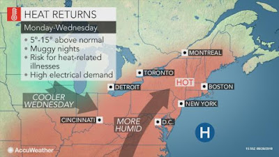
| Hot and humid air will surge into Montreal and southern Quebec this week. Humidex values are expected to exceed 40C on Tuesday. (AccuWeather) |
The hot weather will also extend into eastern Ontario, and south of the border across New York and New England. A heat advisory is in effect stateside for the St. Lawrence and Champlain Valleys. The late season heatwave will add to an already smoking hot summer. In the 84 days since the start of meteorological summer on June 1, Montreal has exceeded 27C (80F) on 50 of those days. Included in that total are 15 days above 30C (86F).
Warm Fall
The late summer heatwave should come to an end on Wednesday, as a strong cold front ushers in cooler and dryer air. There is a chance of scattered severe thunderstorms on Wednesday for a portion of our region. With August drawing to a close, our attention will shift to fall. Current indications suggest a warm and dry September is on tap for southern Quebec. A weak El Nino is expected to develop through the fall and intensify into the winter months. If this scenario holds true, we may be looking at above normal temperatures through Christmas and into the new year.
No comments:
Post a Comment