 |
| A developing coastal storm will bring a mix of rain and snow, along with strong winds to southern Quebec this weekend. Most of the precipitation should fall as rain in Montreal, but a messy mix may fall north and west of the city. (AccuWaether.com) |
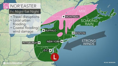
A developing nor'easter is forecast to move from coastal North Carolina towards southern New England on Saturday. The storm is forecast to strengthen while pushing moisture northward into southern Quebec by Saturday morning. Temperature profiles suggest a mix of snow and rain here in the St. Lawrence Valley, with any accumulations confined to the higher elevations. A cold northeast wind is expected, gusting up to 50km/h, keeping the cold air in place in Montreal. At this time, the best chance for accumulating snow would lkely be overnight Saturday. The precipitation should last most of the weekend, with the potential for more than 25mm of rain and perhaps several centimetres of snow for some. The storm should lift northeast across New England on Sunday, with slowly improving conditions by late in the day.
 |
| Low pressure surprised many parts of northern New England, the Gaspe and New Brunswick, with the first major snowfall of the season on Wednesday. Over 30cm of snow fell on Mount Washington, New Hampshire, with 15 to 25cm falling in the Gaspe peninsula. (Maine Forest Rangers photo) |
On Thursday, Montreal experienced a cold, breezy day, with the temperature only reaching 2C (36F). Partly cloudy skies along with diminishing winds, should allow the temperature to drop well below freezing in southern Quebec by Friday morning. A thick frost or freeze is likely. Friday will be the best day in the foreseeable future, with sunshine and high temperature near 6C (43F).


No comments:
Post a Comment