 |
| A massive late season tornado rolls across central Illinois on Sunday. The storm was one of at least two dozen tornadoes to impact the state. The tornadoes, some as strong as EF-3, produced widespread damage and numerous injuries. Miraculously no fatalities occurred. (TWC Photo) |
The strong storm that swept across the central portion of the continent this week, is ushering in much colder air into eastern Canada. The cold air will remain in place for the short-term period, with a reenforcing shot of arctic air arriving Friday. Montreal was on the warmer side of the storm this past weekend, with over 25mm of precipitation falling, ranging from wet snow, to freezing rain to plain rain. Icy roads produced accidents on Sunday morning, especially north of the city. The same storm was responsible for heavy snow along the northwest flank of the system, as well as rare December tornadoes in the warm sector across the US Midwest. The thunderstorm activity even nudged northward into southwest Ontario on Sunday afternoon and evening, with vivid lighting illuminating snow covered fields.
 |
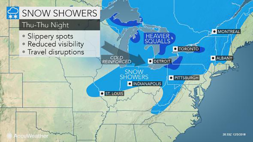
| An arctic front will produce flurries and squalls late Thursday, ushering in a very cold airmass for Friday and the weekend. The cold will be short-lived, with milder weather expected to return next week. (AccuWeather.com) |
The sun is finally expected to make a brief appearance in southern Quebec on Tuesday, along with some clouds and perhaps a snowflake or two. The weather will be blustery and noticeably cooler, with temperatures reaming in the -4C to -6C (21-24F) range. On Wednesday, clouds will begin to increase once again as a clipper type system arrives from western Canada. These are typically moisture starved storms, and this one will be no different. Some light snow is expected Thursday, with perhaps a few centimetres accumulating. A rather potent arctic front will cross the St. Lawrence Valley late Thursday, accompanied by some robust snow flurries. Behind the front, much colder air will arrive for Friday and the upcoming weekend with lows approaching -18C (0F) for many. The good news is high pressure will dominate, with sunshine expected to accompany the cold weather. No major snowfalls are on the horizon at this time, with the storm track remaining well south of Quebec through the middle Atlantic states.
Looking ahead to the rest of December, it is becoming more likely that a major pattern change will be underway. Above normal temperatures are anticipated through the middle portion of the month, along with below normal precipitation. Depending on which computer model you prefer, a white Christmas for Montreal may be in jeopardy, or salvaged at the last minute during the week leading up to December 25th. Time will tell.

No comments:
Post a Comment