 |
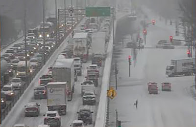
| Schools are closed and traffic is at a standstill in may parts of Montreal Friday morning, after nearly 20cm of snow and ice fell overnight. |
A potent winter storm has resulted in heavy rain and snow along with rapidly dropping temperatures over the last 36 hours. Highways are in very poor shape Friday morning, icy and snow covered. Numerous accidents have been reported in the Montreal region. Nearly every school board in southern Quebec has opted for snow day today, with more than 18cm of snow falling overnight in Montreal.
The change in weather was quick after a spring-like day on Thursday, featuring record breaking warmth for most of us. The high at Trudeau was 6.6C (44F), just shy of the record of 6.8C (44.2F) set in 2011. Here on Ile Perrot and across the off-island suburbs to the west, the high reached a balmy 9C (49F).
Late last evening a cold front crossed the St. Lawrence Valley, with rain mixing with sleet and freezing rain around 9pm and changing to snow shortly afterwards. The snow was heavy overnight, but has become lighter this morning and should end by noon. Storm totals are very impressive, with 27.6mm or rain falling in Montreal, followed by at least 20cm of snow. The temperature has dropped all the way to -10C (14F) as of 8am Friday.
The storm in question is over northern Maine this morning moving east, while the cold front has shifted into southern New England. High pressure will briefly clear skies this afternoon, along with steady or cooling temperatures, down to -15C (5F) tonight. On Saturday, a weak low pressure area will skirt across southern Quebec with light snow expected and windy conditions. Another 5cm of snow is expected for Montreal.
A very active weather pattern is expected next week, with moderating temperatures, and more mixed precipitation likely.

No comments:
Post a Comment