Rain starting in Montreal at this hour. Radar shows the heaviest precipitation southeast of the city near Lacolle, QC and Champlain, NY and moving northwest towards St. Lawrence Valley of Quebec and Ontario. I will be on the road for a few hours today so look for updates/photos via twitter
Sunday, August 28, 2011

Irene Update
 10am Update: Above - Irene inland over southeast New York. Rain now just south of Montreal with heavy rain just south of the US border moving towards the city.
 From the Canadian Hurricane Centre, the forecast track of Irene through southern Quebec and Atlantic Canada.
9:30 Update: Irene landfall was near NYC at 0900 this morning and she has now been downgraded to a tropical storm with 65mph winds. The pressure is 965mb, moving northeast at 25 mph.
Hurricane Irene is located this morning on the coast near New York City. The large storm system has winds of 75mph and some slow weakening is forecast today as Irene moves inland over southern New England and up the Connecticut River Valley between Vermont and New Hampshire. Irene will then move into southern Quebec and New Brunswick. Montreal is already feeling the effects of the storm. At 9am we are cloudy with a northeast wind of 39 km/h. Winds are forecast to increase to between 70 and 100km/h today. The storm has been drawing in some dry air and has also experienced some shear. Despite this tropical storm force winds extend outwards nearly 300 miles from the center. Where we may see a break in the forecast is in the rain department. Radar is showing very heavy rain across Vermont extending just into Quebec at this hour. It will continue to nudge towards the St. Lawrence Valley. Heavy rain warnings are in effect for all of southern Quebec and now also include southeast Ontario including Cornwall and Glengarry County. Over 50mm is expected this afternoon into tonight with as much as 100mm locally. However the storm is moving faster now and rainfall amounts may be less, we will have to wait and see.
Saturday, August 27, 2011
Irene update
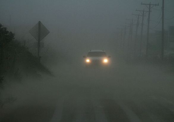
 Above are two very familiar spots to me from the Outer Banks. North Carolina 12 in the heavy rain and wind and the awning down at the BP I gas up at in Avon, NC. Below the northern cloud deck of Irene has reached Montreal. Photos are from the Virginia Pilot.
8pm: Hurricane Irene is back over the open waters of the Atlantic Ocean just east of Virginia Beach and about 315 miles south southwest of NYC. Hurricane Warnings remain in effect up and down the east coast with Tropical Storm Warnings in effect for Nova Scotia and New Brunswick. Heavy rainfall warnings for 40-60mm of rain and high wind warnings for winds between 60 and 100km/h remain posted for southern and eastern Quebec. Already the northern cloud deck from Irene has pinwheeled into southern Quebec this evening with the precipitation as far north as Albany, NY. The strongest winds should reach the St. Lawrence Valley of southern Quebec by daybreak Sunday and persist most of the day. Irene has been deadly today, responsible for 8 fatalities and millions in damage. Nearly 1 million residents are without power on the east coast and that number is growing. Wind and water damage from Irene and several tornadoes spawned by her continues to occur from the Carolina's into the middle Atlantic including one minutes ago near Lewes, Delaware. Tonight a tornado watch is posted until 5am for a large swath of the northeast including metro New York City. Thousands have been evacuated form the coast with nearly 9000 flights into NYC cancelled. Public transit has also been closed until further notice.

Irene Update
 Image of North Carolina 12 at Mirlo Beach completely inundated by the Atlantic Ocean. This basically closes off Hatteras Island to the north.

The ghostly image of the Cape Hatteras Lighthouse being lashed by Hurricane Irene this morning.
Hurricane Irene has made a landfall at Cape Lookout, North Carolina at about 7:30AM this morning. I have been looking at local observations and it appears strong winds have been buffeting Ocracoke and Hatteras Island since midnight. A wind gust to 125km/h was observed on Ocracoke, with 137km/h at the Lighthouse on Hatteras. Heavy rain has also been falling with flash flooding. Winds have toppled trees and power lines with thousands without power. Scattered tornadoes overnight also caused considerable damage. Reports from the NWS in Newport indicate about 5 to 7 inches of rain overnight with a storm surge of 5 to 9 feet along the sounds and coast. I am trying to determine damage on the Outer Banks south to the Core Banks. I am listening to the hurricane net and so far this morning lots of tornado warnings are being posted for southeast Virginia as heavy squalls move inland.
Warnings remain in effect up the entire east coast to Maine. Inland tropical storm warnings are in effect for southern New York and New England.
Synopsis for Montreal: Here is a breakdown of what will happen in southern Quebec. Irene has weakened this morning to a category one storm with 90 mph winds. Despite this she remains a big wind and rain maker and will continue to do so into Sunday. Montreal remains on the western edge of the system with a very sharp drop off of weather expected west of the city. That being said it looks like about 50 to 100mm of rain beginning early Sunday and lasting all day from the city east and southeast. Eastern Ontario may only see scattered showers. The rain will be capable of producing flash flooding especially in the Townships and points east. A high wind warning is in effect for Montreal and southern Quebec. The valley will help channel northeast winds into the city with gusts between 50-90km/h throughout Sunday. Winds of that strength are capable of downing power lines and trees. Winds will back to the north late in the day and drop to 50km/h. The strongest winds will be in the St. Lawrence Valley and across the higher elevations of southern Quebec. More updates to follow via twitter.
Warnings for southern Quebec
I am preparing a full statement, but as a result of Hurricane Irene, we have high wind and heavy rain warnings in effect for southern Quebec.
Heavy Rain Warning : 50-100mm (2-4 inches)
High Wind Warning : Increasing northeast winds to 50km/h tonight and up to 90km/h by Sunday morning.
Heavy Rain Warning : 50-100mm (2-4 inches)
High Wind Warning : Increasing northeast winds to 50km/h tonight and up to 90km/h by Sunday morning.
Friday, August 26, 2011
Hurricane Irene lashing NC

Irene approaching the Carolina coast tonight. This Environment Canada radar image gives you a good idea of the distance between Montreal, Quebec and the storm center.
Locally a flash flood watch is now in effect for all of Vermont and northern New York. A tropical storm watch is in effect for the southern tier of New York, the Hudson Valley and New Hampshire. Rainfall of 1-3 inches is possible from the St. Lawrence Valley east to Lake Champlain with 3-7 inches in Vermont. Flash flooding is expected in Vermont. High wind watches are also in effect. Forecasters at the National Weather Service in Burlington are expecting winds in excess of 35 mph with gusts as high as 60 mph in the Champlain Valley and across the spine of the Adirondacks and Green Mountains. In southern Quebec and more specifically Montreal, heavy rain will begin Sunday and continue much of the day and into the evening. Amounts will likely be in excess of 25mm here as we remain just on the western edge of the rain shield and much more south and east of the city. Winds will increase late Saturday night from the northeast and gust 30-50km/h overnight and stronger on Sunday.
Irene update

10:10 AM: Here is an image I looked at so much while on vacation this past May on Hatteras Island. It is the local radar from Buxton, showing the outer edges of Irene just south of Cape Hatteras.
 All the collective energy in the world does not seem to be wishing Irene away from the Outer Banks. I pray for my future retirement destination and for all the permanent residents of the fragile barrier islands off the North Carolina coast.
Here is what you need to know about our weather this weekend. Hurricane Irene this morning is a category 2 storm with 110mph winds located about 350 miles south southwest of Cape Hatteras, North Carolina. The storm is moving northward at 14 mph and should reach the Outer Banks by Saturday afternoon. A hurricane warning is in effect from the North Carolina/South Carolina border northward to Sandy Hook, New Jersey. North of Sandy Hook a watch is posted up to Merrimack River, Mass on the New Hampshire border. This watch includes Long Island and Metro New York City. Evacuations are well underway in coastal areas from the Carolinas to the Jersey Shore.
Irene is forecast to move up the coast and come onshore very close to New York City on Sunday. At this time the storm is then forecast to cross interior New England and move into southern Quebec and the Gaspe region. Locally no watches are in effect at this time. Today and Saturday will be partly cloudy with increasing northeast winds late Saturday. Sunday looks very windy in Montreal, gusts over 50km/h quite likely. Rain will develop in the afternoon and become very heavy east of the city. Amounts will range from 25mm over western regions to as much as 200mm well south and east of the city and into the Townships and Vermont. Flooding is likely in Vermont and eastern Quebec with a watch of some sort expected later today or early Saturday.
I will have much more as the day and weekend progresses, either by blogging or via twitter. Please stay safe this weekend.
Thursday, August 25, 2011
Hurricane Warnings
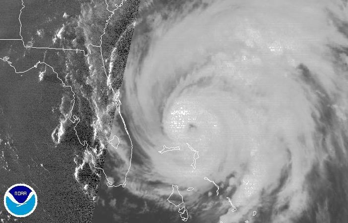 Hurricane Irene has been pounding the Bahamas all day.
Hurricane Warnings are up for the North Carolina coast tonight to Virginia Beach with a Hurricane Watch north of there to Sandy Hook, New Jersey. A state of emergency is in effect for the coastal counties of North Carolina with evacuations ordered in Hyde, Dare and Currituck counties. Tropical storm conditions are expected to overspread the area by late Friday. Evacuations have also been ordered along portions of the coasts of Delaware and Maryland and will likely be extended north into southern New Jersey on Friday. A state of emergency is also in effect for New York City. Large and dangerous Irene is located about 530 miles south southwest of Cape Hatteras with 115mph winds. The storm is forecast to approach the Outer Banks and pass west of the cape on Saturday. Computer models tend to be favouring a more western route for the storm. That spells bad news for North Carolina as well as the northeast. The storm is expected to move into New York and New England on Sunday with heavy flooding rains and powerful winds. Montreal remains on the western edge of the model runs so we will likely see strong northeast winds and rain by Sunday. Most of eastern Quebec and Atlantic Canada can expect tropical storm force winds and heavy rain if Irene remains are her current forecast track.
Hurricane Watch for NC
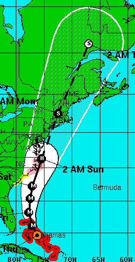 A hurricane watch is in effect for the entire North Carolina coast including the Outer Banks. Irene remains a large and powerful category 3 storm this morning with every indication that she will gain strength over the warm waters east of Florida today. The storm counties to tear into the Bahamas with heavy rain and strong winds. There have been reports of flooding, damage and power failures. Once the storm clears that region it will take aim at the Carolina coast and points north.
There is increasing concern along the middle Atlantic and northeast into New England and eastern Canada this morning. The region had heavy rain last week and the potential for serious flooding exists. At this time hurricane conditions will spread across the Outer Banks Saturday, evacuations are underway today. On Sunday the storm will move northeast along the coast and slam into Long Island. The forecast track at this time, subject to change, ha
 s Irene moving into New Hampshire and then southern Quebec as a tropical storm. East of the track heavy surge and wave action will affect the coast while along and west of the track heavy rain and strong north and northeast winds are expected. With this track, Montreal would remain on the western edge of the storm with rain and strong winds by Sunday. I will have much more on Irene as the day moves along with the next complete update this evening. All the links on this page are active with information.
Above: The NHC forecast track for Irene.
At right: Two locations I know so well on the Outer Banks. I have waited at that ferry terminal on Hatteras Island 100 times if not more.
Wednesday, August 24, 2011
Active weather pattern
 Radar image of Irene this evening.
We have so much weather going on tonight I am not sure where to begin. We will start in Ontario where a cold front has prompted a day long tornado watch for a big portion of central and southern Ontario. After the F-3 Goderich twister last Sunday, Environment Canada appears to be airing on the side of caution with this one, with conditions reasonable for some severe storms and rotation. Heavy rain and dangerous lightning appear to be the main threats with these storms. They are marching across Ontario and should begin to affect southern Quebec after midnight. Some may be strong around Montreal as well with heavy rain and gusty winds.
Hurricane Irene
Meanwhile all eyes are on hurricane Irene tonight as the storm moves slowly across the Bahamas, northwest at 12mph. It is currently moving between Rum Cay and Long Island. The category 3 storm has winds tonight of 120mph and is expected to increase to category 4 on Thursday. The large storm has tropical force winds extending outwards up to 230 miles from the center. I am very concerned for the Outer Banks of North Carolina, a place I like to call my second home. The location and its residents are very special to me. It appears that Irene may move over or very close to the Outer Banks by Saturday with Category 3 force winds, heavy rain and a storm surge. Then we need to look further up the coast into New York and New England as well as Eastern Canada. The Canadian Hurricane Center has issued a special statement for southern Quebec and Atlantic Canada to pay close attention to Irene and expect high winds and heavy rain in a portion of the forecast region by late Sunday and Monday.
Irene a category 3
 This will be brief, Irene is now a category 3 storm with 115mph winds heading for the Bahamas. The storm will further intensify and affect the Outer Banks of North Carolina up to New England and the Maratimes this weekend. Evacuations will begin on Ocracoke this morning and likely spread to Hatteras and Bodie Islands later today. More later today.
Tuesday, August 23, 2011
Quake rattles east coast
 Damage in Washington DC from a 5.8 quake today (Getty Images)
A moderate earthquake of 5.8 rattled the east coast from Montreal and Toronto south to Florida. The quake occurred at around 2pm close to the small town of Mineral, Virginia about 90 miles northwest of Washington D.C. While others in Montreal told me they felt the swaying for about 30 seconds, I must admit I did not. Office buildings in New York, Boston and other cities were evacuated, as was the White House and Pentagon. Minor injuries were reported with some serious damage scattered throughout the mid-Atlantic with the worst close to the epicentre in Virginia. Scattered power outages were reported and several nuclear plants were placed on alert or taken offline. Train and plane service slowed or stopped immediately after the quake and is slowly returning to normal. The quake was the worst to affect the region in nearly 100 years.

The region is also preparing for what could be a major hurricane by the weekend. Hurricane Irene is centered near the Turks and Caicos Islands this evening with 90mph winds, a little weaker than earlier today but still expected to become a major hurricane over the next 48 hours. Computer guidance has been shifting the track of the storm further east away from Florida with the last several runs and it now looks like the Outer Banks of North Carolina could be a target. Anybody who knows me or reads this blog knows my connection to Hatteras and Ocracoke Islands. I have been vacationing there since 1991 including this past May. The thin, fragile barrier islands look like they could take a direct hit from the storm. Further up the coast residents from Virginia to Nova Scotia are being advised to monitor the storm closely. I will have much more on Irene this week, updating via Valley Weather blog or twitter as often as I can.
Monday, August 22, 2011
Irene now Category 2
 Hurricane Irene on visible satellite image this evening.
A hurricane hunter has reported 100mph winds with Hurricane Irene this evening. That makes the storm, the first hurricane of 2011, now a category 2 on the Saffir Simpson scale. The storm is expected to maintain a northwest motion at 10mph and skirt the northern coast of Hispaniola before heading into the Bahamas Tuesday. Forecasters expect Irene to become a major hurricane on Tuesday. The forecast track of the storm has it approaching the southeast coast of the US as a major storm by Saturday. The latest guidance has the storm now missing Florida and threatening the Carolina's.
Sunday, August 21, 2011
Tropical Storm Irene
 Tropical Storm Irene developed yesterday in the Caribbean Sea southeast of Puerto Rico and is hammering the region tonight with heavy rain. A hurricane hunter aircraft has reported winds of 60 mph and further strengthening is expected. Irene will likely become the first hurricane of the season on Monday. The storm is expected to affect Haiti and the Dominican Republic before heading toward south Florida later in the week possibly as a strong hurricane.
More storms tonight
The tornado warning has been allowed to expire, but a severe thunderstorm warning remains in effect for Lacolle and the region along the US border from New York into Vermont. Heavy thunderstorms with hail and strong winds continue to develop in the unstable and humid air mass in the region. They will affect all of southern Quebec tonight with heavy rain and gusty winds. West of Montreal a large area of showers and storms is heading towards the city. The precipitation will continue until well after midnight. While it is not severe at this time, heavy rain is expected. Severe Thunderstorm Warnings are also in effect for eastern Ontario.

This afternoon at around 4pm, Goderich on the shores of Lake Huron suffered tremendous damage in the downtown from what is suspected to be a tornado (see above photo from The Weather Network). The damage photos are unbelievable. One fatality may have occurred with the storm according to OPP. Tree and roofs were torn down and homes damaged. Cars were tossed around and golf ball size hail was reported.
Severe Thunderstorms

6:45 pm - The latest myweather.com radar showing strong storms across the region including rotation near the US border.
Strong thunderstorms have been occurring all day across southern Ontario, southern Quebec and into northern New England. Heavy rain has been the story so far, but strong winds and hail have developed along the Lake Champlain shoreline with some of the storms. Radar has even indicated rotation with one storm just east of Lacolle moving northeast. Severe Thunderstorm Warnings are in affect for the region south of Montreal to the US border and east into the Beauce region. Earlier today a water spout was reported near Gananoque, Ontario.
Friday, August 19, 2011
Weekend Update
 Ron Fellows NASCAR race car at the Canadian Tire on St. Charles yesterday,
before the thunderstorms. (ValleyWx Pic)
It is two years today since my dad passed away.
As always this blog is written for him. See post HERE.
The weekend forecast will be 50/50 for the entire region with a sunny and warm Saturday followed by showers and thunderstorms and cooler for Sunday. The weather Saturday will be ideal for the NASCAR NAPA Auto Parts 200. I have my tickets, if your going bring the sunscreen and water, it will be sunny at 30C with just a few stray clouds. This morning we have already warmed to 22C and it is quite humid after some overnight showers. The day should be sunny and warm at 28C with just a slight risk of an isolated shower or storm, especially south of the city towards the US border.
The tropics are heating up with tropical depression 8 southeast of Belize City with 35 mph winds and a couple of invests in the Atlantic. The next storm will be Harvey. Look for the development of several disturbances over the next couple of days. I will have more information on that late today.
Wednesday, August 17, 2011
Perfect summer day
You can feel the days of summer passing us by. Last evening I noticed some trees in our neighborhood showing signs of color. The days are getting shorter and the longer nights mean cooler temperatures. After yesterday's high of 27C most areas across southern Quebec dropped to between 10 and 15C this morning, however there were some notable exceptions. Mirabel was 9C (48F) and St Jovite 5C (41F) this morning. The winner for an early fall chill this goes to La Grande where it was 2C (34F). We will recover nicely here in Montreal today, under bright sunshine we should reach 27C (81F). The balance of the week will be warm and muggy with temperatures near 28C right into the weekend. There is a risk of thunderstorms on Thursday and Friday and again on Sunday. The weather at this time looks perfect for the NASCAR NAPA Auto Parts 200 at Circuit Gilles Villeneuve on Saturday.
Tuesday, August 16, 2011
Elvis and Camille
 Damage from Camille in 1969
ELVIS: Also of note on this date was the death of Elvis at age 42 in 1977. Most people remember where they were when the heard the news, I was on a VIA train. Of course I am going to put a weather spin on this. I was only 11 years old and was traveling with my mother and grandmother to Ottawa for the day. I remember it was unseasonably cool and very rainy in both Ottawa and Montreal. A quick look at the stats showed a high of 18C with rain and fog in both cities, 4.8mm in Montreal and 16.0mm in Ottawa.
**More showers are possible today as an upper level low continues to spin over eastern North America. The heaviest rain yesterday remained over New England and New York. It will be warmer today and the instability could result in a shower or two this afternoon in southern Quebec. Skies will clear for Wednesday with warmer weather, close to 29C.
Monday, August 15, 2011
NYC flooding
 Flooding in Massapequa, New York on Sunday. CBS 2
A record 7.72 inches of rain fell at JFK yesterday flooding roads and basements and knocking out power to thousands in metro New York City. The rain, part of a system that stretched from the middle Atlantic to the northeast, generated slow moving thunderstorms that deluged many areas. The northern edge of the same system produced severe thunderstorms in our region with gusty winds and heavy rain. Trudeau Airport reported just under one inch of rain (22mm) for the 24 hours, I measured about 0.5" (15mm) at my home west of the airport. Heavier rain occurred southwest of Montreal and into eastern Ontario and upstate New York. As the upper level low over Ohio and the coa
 stal system move slowly northeast today, more showers are possible with heavy amounts up to 2 inches (50mm) across the region in the slower moving cells. Radar is showing showers and some thunderstorms over southern Vermont moving north this morning. They should reach southern Quebec by the afternoon. The air mass will remain unstable well into Tuesday before drier air moves in from the northwest lowering dew points and humidity levels. Wednesday and Thursday look sunny and warm at this time.
Above: Accu-Weather Radar this morning.
Subscribe to:
Posts (Atom)