 |
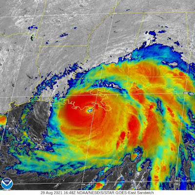
| Satellite image taken at landfall of powerful hurricane Ida, 12:55pm Sunday near Port Fourchon, Louisiana. (NOAA/NWS) |
UPDATE 12:55 PM: Landfall of powerful category 4 Hurricane Ida at Port Fourchon, Louisiana with 150mph winds gusting to 165mph.
As expected Ida has rapidly strengthened overnight, reaching category 4 status over the last few hours. As of the 7AM advisory, Ida had 150mph (241km/h) winds and was moving northwest at 15 mph (24km/h). The storm continues to deepen over very warm ocean waters. Landfall is expected close to Grand Isle, Louisiana by late afternoon. The Hurricane Hunter aircraft have been entering the storm non-stop over the last few hours, relaying back vital information to forecasters at the National Hurricane Center.
Already this morning seas are building and surge is starting to impact coastal communities from Alabama to east Texas. Strong rain bands are already pivoting into the region, accompanied by torrential rain, gusty winds and isolated tornadoes. Thousands have fled inland, but the rapid arrival of the storm has meant many have remained sheltered in place. This is the first major test for the billion dollar levee system protecting New Orleans. The entire system was overhauled after the catastrophic failure and loss of live after Katrina on this date in 2005.
Ida is expected to generate a storm surge of up to 15 feet and over 20 inches (500mm) of rain. The storm will continue to strengthen until landfall. This is on ongoing story and I will provide additional updates today.
No comments:
Post a Comment