Sunday, October 31, 2021

Wet and windy Halloween in Montreal

The steady rain should taper off to showers in time for trick or treating Sunday evening in Montreal. Temperatures will hold steady between 8C and 10C.

Deepening low pressure will lift from Cape Cod northwest towards Sherbrooke this Halloween, spreading rain into southern Quebec and extreme eastern Ontario. The rain will be steady, if not heavy at times, with an additional 25mm forecast for Montreal. Around 15mm has already fallen across southern regions of the province since midday Saturday. I am still hopeful that the heaviest precipitation will lift off to the northeast by 6pm, allowing for trick or treating in Montreal. In terms of temperatures, they should remain steady for most of the day around 10C (50F), dropping to 8C (48F) by 6pm.

The evening won't be perfect for the kids, showery at times, damp and cool, but nothing they can't handle. Halloween has taken a beating over the last three years, with the Mayor of Montreal cancelling it in 2019 due to poor weather (although we has nearly 100 kids in the rain and wind on Ile Perrot), followed by the Covid nonsense in 2020 and now more rain this year. We are certainly ready with our treats for the ghosts and goblins, but not really sure what to expect.

I do remember how exciting Halloween was as a kid growing up in the 1970s. I will tell you one thing, the weather never stopped us. 

Looking ahead to Monday, a cold front will slide across the St. Lawrence Valley accompanied by a shower or two, and strong west winds up to 60km/h. Temperatures will hold steady around 9C (49F) Monday before dropping do 5C (41F) by Tuesday morning.

There remains the chance for some light snow flurries midweek across our regions, as colder air settles into Ontario and Quebec.

Thursday, October 28, 2021

Powerful Nor'Easter hammers New England

A tree lies across a car in Duxbury, Massachusetts after a powerful early season Nor'Easter delivered winds in excess of 75mph to the region. Over 330,000 residents remain without power Thursday morning, including entire communities. (WBZ)

Residents of coastal New England are cleaning up on Thursday after the first Nor'Easter of the season hammered the region on Wednesday with hurricane-force winds and towering waves.

Winds remain gusty across southern Quebec early Thursday morning, in response to high pressure moving in form the northwest and strong low pressure moving out to sea east of New England. The Nor'Easter produced wind gusts up to 60km/h (37 mph) on Wednesday in Montreal.

The storm was much more impactful across coastal regions of New England, with heavy rain and hurricane-force winds reported. Winds gusted between 75 and 100 mph (119 to 160km/h) in many communities from southern Maine to Rhode Island. Hundreds of trees came down, many onto homes and vehicles. Over 500,000 residents were without power at the height of the storm on Wednesday. Nearly 330,000 remain without power Thursday morning, with dozens of schools closed for a second straight day.

A small aircraft sustained serious damage after being tossed by the wind in New Bedford, Massachusetts on Wednesday. (WBZ)

Thirty foot waves pounded the shoreline, with some roads closed due to flooding. The storm also produced 25 to 100mm (1-4 inches) of rain across the region. Officially just under 15mm fell in Montreal, as we remained on the far western edge of the storm system.

The storm in question developed early in the week off the mid-Atlantic coast, before rapidly intensifying southeast of New England. The system become a weather bomb, with the central pressure dropping more than 24 millibars in less than 24 hours.

The stormy weather pattern is expected to persist, with another system arriving on Saturday. Rain is forecast this weekend in Montreal, likely tapering off to scattered showers in time for Halloween. 

A strong cold front is expected to arrive by next Wednesday, with the possibility of accumulating snow for some portions of southern Ontario, Quebec and northern New England.

Monday, October 25, 2021

Stormy weather pattern developing across North America

While we await our first taste of winter here in southern Quebec, the weather is turning stormy in other parts of our region. Wet snow greeted motorists across the highest elevations of northern New Hampshire on Monday morning. (New Hampshire Department of Transportation)

October can be a month of transition as we head into winter. So far, the weather has been a rather tame in Montreal compared to previous years. While we flirted with the freezing point this past weekend in Montreal, we remain frost and snow free to date. Weather patterns are beginning to change across North America, and we are seeing more major storm systems developing.

The upcoming week will certainly turn more stormy over eastern North America, with several systems impacting the region. Low pressure over the Great Lakes will move south of Montreal, while a second stronger storm system develops off the eastern seaboard. The second system will produce very heavy rain and strong winds across portions of New England, but the worst of the weather should remain south of Montreal.

A strong Nor'Easter, the first of the season, is forecast to develop early this week southeast of Long Island. Montreal will remain on the northern edge of the storm, with gusty northeast winds and showers. Temperatures will be rather chilly to start the week. (AccuWeather.com)

Showers are forecast today into Tuesday across southern Quebec, with perhaps 15 to 20mm of rain, far less than what was expected 24 hours ago. Chilly northeast winds will develop on Monday and persist into Tuesday, gusting at times to 60km/h in the St. Lawrence Valley. Temperatures will be chilly, remaining in the single digits through Tuesday, and perhaps reaching 12C (54F) by Wednesday.

Another potent storm system is expected to arrive by Friday, with more rain and wind expected into Halloween. I am hopeful at this time that the precipitation should taper off in time for trick or treating in Montreal.

The current storm is expected produce very heavy rainfall and wind gusts over 100km/h for portions of coastal New England. Some snow was even falling Monday morning across the highest elevations of extreme southeastern Quebec, northern Maine and New Hampshire. Power outages and coastal flooding are anticipated. The stormy weather will spread into far eastern Quebec and Atlantic Canada by mid-week.

A series of powerful west coast storms are delivering heavy rain and hurricane force winds to parts of the Pacific northwest and British Columbia. The energy from those systems will eventually fuel new storms over the central portion of the continent to end October and start November.

Thursday, October 21, 2021

First frost of the season on the horizon for Montreal

A frost warning may be required for metro Montreal for Saturday night.

The onset of the cold weather has certainly been slow across eastern Canada this fall. Southern Quebec experienced another mild day on Wednesday, with high temperatures in the middle to upper teens across the region. Trudeau Airport registered a high of 18.2C (65F), well above the long-term average of 11C (52F) for the date. We are already at 13C (55F) Thursday morning. This trend will persist for another day or so before a potent cold front arrives on Friday.

Ahead of that front, we can expect scattered showers Thursday, with a period of steady rain and perhaps a rumble of thunder late tonight and into the wee hours Friday morning.  On Friday, Montreal will have a noticeable change in the airmass, as temperatures drop into the upper single digits by afternoon, along with a gusty west wind up to 40km/h. Clouds will persist with perhaps a sprinkle or two.

Skies will be partly cloudy throughout the weekend, along with seasonable temperatures. If skies clear out completely Saturday night into Sunday morning, there is a very good chance that Montreal will have the first frost of the season. The overnight low is expected to drop to the freezing point in the city and below in the suburbs. The average day of the first frost in Montreal is October 5.

Beyond the weekend, seasonable temperatures are expected next week, with no major storms on the horizon at this point.

Friday, October 15, 2021

Strong cold front to bring an end to the warm weather in Montreal

A return to reality...

Much cooler, fall weather will return this weekend to southern Quebec. High temperatures on Sunday will only be in the low teens.

Temperatures have been running well-above normal this week across southern Quebec as our warm and dry fall weather persists. The morning low on Thursday was only 16.8C (61F), which established a new record for maximum low temperature that dates back to 1970 (15C). Montreal has had no frost as of today, which places us well behind the last couple of years and certainly short of the average date of October 5. Looking ahead, we should make it to end of the month in the Montreal metro region with no frost or freezing temperatures.

That being said, we will see a dip in the temperatures and a return to more seasonable weather for mid-October. Dirty high pressure has been in control of our weather this week, with plenty of low level moisture, humidity and cloud cover trapped at the surface. The result has been a very warm, but rather gloomy week, with just a few breaks and even some mist or drizzle at times.

Over the next 24 hours a warm front will lift across the region, accompanied by showers. On Saturday, a strong cold will approach the St. Lawrence Valley during the early afternoon, accompanied by steady rain and even a few embedded thunderstorms. At this time rainfall amounts look to be significant, with up to 30mm in Montreal, and locally in excess of 50mm across portions of eastern Ontario and southwestern Quebec. The weather has been a very dry this month, with only 8.2mm of rain to date.

The front will also usher in much colder air. High temperatures will be either side of 21C (70F) today and Saturday, but dip into the single digits by Sunday morning. The high on Sunday and Monday, with lingering clouds and showers will struggle to reach 10C (50F). Overnight lows will return to reality, dropping to 4 to 6C (39 to 43F).

The front will also produce a period of gusty southwest winds on Saturday, backing to the northwest late in the day, between 40 and 60km/h in Montreal.

Wednesday, October 13, 2021

Record warmth in eastern Canada - snow out west

Portions of several Interstates were closed on Tuesday afternoon, stranding travelers from Montana into Wyoming and South Dakota. The snow spread into southern Saskatchewan and Manitoba late Wednesday. Meanwhile the weather has been warm in eastern Canada, with highs in the middle 20s and overnight lows warmer than the long-term highs for the date. (Montana Department of Transportation)

A large ridge across the eastern portion of the country is providing Montreal and most of southern Quebec and Ontario with unseasonably mild fall weather. Thanksgiving weekend was spectacular, with just a few clouds and sprinkles Sunday but otherwise very warm and pleasant. Temperatures have been in the low to middle 20s, a full ten degrees above average. Tuesdays high temperature of 23.8C (74F) at Trudeau Airport was just one tenth of a degree away from the record high set in 1961. Several new high temperature records were established from New Brunswick to Ontario.
The mild weather will persist into Saturday before the arrival of a potent cold front. Temperatures will remain mild throughout that time frame, with highs in the low 20s, and overnight lows in the middle teens.

By Saturday the aforementioned cold front will arrive in Montreal with and increase in clouds, windy conditions and some heavier showers. The wet weather will persist into Sunday along with much cooler temperatures, only near 12C (54F) for a high. Overnight lows will drop into the single digits to start next week.

Western Snow
While the east has been warm, the first taste of winter has arrived across the west. Strong low pressure moving from Colorado to Manitoba, has produced a swath of heavy wet snow. Between 30-60cm of snow fell across portions of Wyoming, Montana and far western South Dakota. Travelers were left stranded as numerous highways were closed including Interstate 90 from Rapid City, South Dakota into Wyoming.

The wet snow also spread into portions of southeast Saskatchewan and southwestern Manitoba on Wednesday, with up 2 to 10cm possible. A special weather statement has been issued for those locations for low visibility in falling snow as well as icy and potentially snow covered roads. On Thanksgiving Day, light snow fell across the foothills of Alberta as far east as Calgary. The western storm is forecast to lift into northern Ontario while weakening. 

No snow is on the horizon for Montreal.

Monday, October 04, 2021

Above normal temperatures set to return to southern Quebec

It was a rainy weekend in Montreal, with a decent amount of precipitation falling in many locations around the city. Trudeau Airport for some reason only measured 7.2mm through Sunday evening, while just a few kilometres to the southwest, 18mm fell in Sainte-Anne-de-Bellevue with 27.8mm on Ile Perrot.

It was a rather chilly, raw weekend in Montreal, feeling very much like the start of October. Saturday was a wash out, with almost 25mm (1 inch) of rain falling across portions of southwestern Quebec. The weekend total was only 7.2mm at Trudeau Airport, but I seriously question that measurement, as most other stations around the area recorded amounts in excess of 15mm. I measured 27.8mm for the weekend on Ile Perrot, with 29mm at St Anicet and 18mm at Sainte-Anne-de-Bellevue. A private weather station at the Baie d'Urfe Yacht Club recorded over 30mm Saturday alone.

Monday will be cloudy and rather cool, with clearing skies sitting just to our north. Seriously you can see the blue skies, just look to the north they have been sitting there for over 24 hours now. The frontal boundary that brought the rain is slowly sinking south over New England this morning. Skies should begin to clear out later today, along with warming temperatures. The balance of the week will feature warm and dry weather, with highs expected either side of 20C (68F). As a matter of fact, the first two weeks of October are expected to have warmer than normal temperatures. The average high for early October is 15C (59F) and the low 5C (41F). Montreal should remain well above those values right through Thanksgiving weekend. There is no risk of frost at this time.

Monday, September 27, 2021

Feeling a little more like fall

September has been absolutely spectacular in Montreal. The fall colours are now beginning to pop as well around the region.

Our streak of 20C September days came to an end Sunday, after a record-breaking 24 straight, we reached only 19.9C (68F) at Trudeau Airport. However the weather was still spectacular this past weekend, with any hint of precipitation remaining well to our east, and the upper level low staying put over the Great Lakes.

The end result was dry weather over southwestern Quebec, with just an isolated sprinkle or two over eastern Ontario. The heavier rain fell over New Brunswick and Maine, with 70mm in Edmunston and 55mm at the Gaspé Airport on Sunday. 

That aforementioned upper level low will slowly drift over our region early this week, with more clouds than sun and isolated showers finally arriving with it. Precipitation amounts will be on the light side for Montreal. Temperatures will remain mild for late September, rising into the high teens Monday. Overnight lows will remain above normal as well, in the 11C to 13C (52 to 55F) range.

High pressure will become reestablished over the region by Wednesday, with dry weather forecast into next weekend. Temperatures will become more seasonable, with highs between 17C and 19C (63 to 66F) and overnight lows between 7C and 9C (45 to 49F). 

The five day forecast track for hurricane Sam, keeps the storm well offshore of the eastern seaboard. The storm may impact Bermuda later this week, and perhaps Newfoundland by the end of next weekend.  (NHC)

Hurricane Sam

The tropics have been very active this September, with multiple named storms forming. Thankfully, most have remained in the open waters of the Atlantic. Sam is a powerful category 4 hurricane Monday morning, located 1290km east southeast of the Leeward Islands. The storm is moving northwest at 13km/h, with 215km/h winds. Sam is forecast to remain a strong storm for the next day or so before some weakening occurs. At this time, Sam is no threat to land, but the system may impact the coastal waters southeast of Newfoundland by next weekend, with perhaps some weather affecting the Avalon region by late Sunday or early next week.

Friday, September 24, 2021

Perfect Saturday weather - showery Sunday for Montreal

The sharp break in the clouds marks the western edge of a stubborn cold front that has been moving across Ontario and Quebec since Wednesday. The front cleared Montreal early Friday morning after dumping 30 to 40mm of rain overnight. (ValleyWeather Photo)

That had to be one of the slowest moving frontal boundaries I have witnessed in my 40 plus years of weather watching. The front took the better part of three days to move from central Ontario into eastern Quebec. Before the front arrived in Montreal, we were treated to a summer-like day Thursday, with a high of 29C (85F), one degree below the record set back in 1961. The low of 20.3C Thursday morning was the warmest minimum recorded for the date.

The cold front produced a steady north south stream of tropical moisture that dumped very heavy rain over parts of Ontario and Quebec. Flooding was reported in several regions of Ontario, with over 150mm (6 inches) of rain reported at Petrolia. Amounts ranged from 50 to 152mm in Ontario, and 30 to 140mm in Quebec. Windsor reported 99mm, Toronto 62mm and Ottawa 48mm. In Quebec, Gatineau measured 90 to 130mm, the Laurentians 90 to 140mm and Montreal 30 to 40mm.

The rain is over, replaced by a breezy, pleasant Friday afternoon. High pressure will nose into the region overnight resulting in clear skies and low of 13C (55F). Saturday will be a spectacular day, featuring light winds, fair skies and a high of 21C (70F). Make that your day for any outdoor activities, as an upper level low is expected to arrive Sunday and control our weather through the first part of next week. The weather will be showery and cooler, with daytime highs in the middle teens.

Our unseasonable warm September continues, with a high of 21C (70F), Friday marks the 23rd consecutive September day over 20C, adding to the record established earlier this week. The previous record was 19 days, set between September 9 and 27, 2007.

Wednesday, September 22, 2021

Heavy rain expected to remain west of Montreal

Montreal lies between two weather systems on Wednesday afternoon, high pressure over Atlantic Canada and a strong upper level low over the Great Lakes. Heavy rain is forecast across Ontario along a slow moving cold front, while Southwestern Quebec will remain relatively dry and very mild for late September.

Summer weather persists across southern Quebec Wednesday afternoon, despite the arrival of fall just a few minutes ago. A slow-moving cold front remains well to our west over central Ontario. That front is the focus for torrential rain and thunderstorms. Widespread rainfall warnings are in effect from the Windsor - Toronto corridor into the Ottawa Valley. Some locations are expecting in excess of 100mm (4 inches) of rain over the next 24 to 36 hours, with flash flooding possible

Meanwhile southern Quebec remains on the east side of the system, with a mild southerly flow, and temperatures well-above normal into the middle 20s. The weather has been exceptionally warm this September, with every daytime high over 20C at Trudeau Airport through Wednesday. This is the first time this has occurred since weather records began in Montreal. The average daytime high through Tuesday has been  22.9C (73F), the normal value should be only 20.6C (69F). We have one more warm day to go before the aforementioned cold front arrives.

The front should begin producing rain and scattered thunderstorms late Thursday into Friday in Montreal. Less rain is expected in southern Quebec as the front will be moving at a faster pace across our region. Expect up to 25mm through Friday morning.

The weekend at this time appears a little more fall-like, with cooler high temperatures expected in the upper teens. A few showers are likely as well by Sunday.

Sunday, September 19, 2021

Near-perfect late summer weather

The harvest moon will light up the evening sky on election day Monday, rising at 7:55pm in Montreal The Autumnal Equinox occurs Tuesday at 3:20pm. eastern time, heralding the end to summer 2021. The weather will be as perfect as it can possibly be for late September in southern Quebec and Ontario.

Fall officially arrives on Wednesday afternoon at 3:20pm eastern time, and with the exception a few high clouds, summer will end with near-perfect weather. There really is not much to add, strong high pressure is in control of the weather across eastern Ontario and southern Quebec and into Atlantic Canada. Expect clear, warm days, with increasing warmth and gusty winds as the week moves along.

A weak front settled across the region early Saturday morning, but as with just about every cold front this summer, it moved across Montreal with little fanfare, just a drop or two of moisture. Skies quickly cleared out leaving us with a beautiful day, and a high temperature of 24C (76F). 

As a matter of fact, 24C looks like the magic number this week. Expect sunshine through Wednesday and perhaps even into Thursday, with high temperatures either side of 24C. Overnight lows will start off fairly cool, in the upper single digits for some locations, as I write the current temperature is 11C (52F) here on Ile Perrot. By the middle of the week, overnight lows will be very mild under southerly winds, in the upper teens. The normal high/low for late September in Montreal, is 18C (65F) and 8C (48F).

Last Wednesday morning, a line of strong thunderstorms put down a quick 10 to 20mm of rain across the city. However conditions remain rather dry, with only 38.2mm of rain falling this month at Trudeau Airport. The normal for the entire month should be 89mm. The longer nights does mean there is dew present most mornings, which is helping a little.

The next chance for precipitation will arrive by Thursday as a frontal boundary and upper level low move across the Great Lakes and into Quebec. We can only hope this system brings some real rainfall.

Friday, September 10, 2021

Hurricane Larry racing towards Newfoundland

A NOAA satellite image of hurricane Larry located southeast of Nova Scotia and south of Newfoundland Friday afternoon. (NOAA)

Hurricane Larry is expected to make landfall across southeastern Newfoundland late Friday evening. The once category 4 hurricane has been roaming the open waters of the Atlantic for over a week. Larry, now a category 1 hurricane with 130km/h winds, was located 750km southwest of Cape Race, Newfoundland at 2pm Friday afternoon. Larry was racing north, northeast at 60 km/h.

A hurricane warning is in effect for the entire Avalon Peninsula through Saturday morning. Tropical storm warnings are in effect across the Clarenville, Burin and Bonavista regions. Larry is a large hurricane, with hurricane force winds extending outward up to 150km from the center. Forecasters expect the worst of the weather in southeast Newfoundland, including St John's around midnight, lasting through 5AM Saturday morning. Wind speeds are expected in the 110km/h range with gusts up to 140km/h along coastal regions. Winds this strong are capable of knocking down trees and power lines, along with some structural damages. Residents are being urged to prepare for a strong storm through the overnight hours and expect widespread power outages.

Hurricane Larry will rapidly approach the Avalon Peninsula Friday evening while transitioning into a powerful post-tropical cyclone. The center will move towards Greenland on Saturday. (NHC)

Storm surge flooding is possible as well, with large waves accompanying Larry as it races northeast into the north Atlantic. Swells from Larry are already impacting coastal regions from North Carolina to Atlantic Canada. Rainfall from Larry will not be as significant as originally expected due to the rapid movement of the storm, with 30 to 50mm forecast.

Larry is expected to remain a hurricane through landfall tonight and then begin the transition into a strong post-tropical cyclone over the Labrador Sea on Saturday.

Wednesday, September 08, 2021

Much needed rainfall across southern Quebec

While recent rainfall is helping, water levels remain very low along the St. Lawrence River. This photo was taken last Thursday in Lachine showing just how low the levels are. The lack of rainfall this summer has created difficult and at times dangerous boating conditions in the rivers and lakes around Montreal. (ValleyWeather)

Since September 1st, approximately 25mm (1 inch) of rain has fallen at Trudeau Airport including just under 4mm today. That amount would not be news-worthy, except for the fact that only 36mm fell on the city during the entire month of August. The rain has been a blessing, helping to green things up a little and increase water levels just a touch on area rivers and lakes.

An absolutely spectacular photograph of a waterspout moving inland near Port Albert, Ontario. The photo was taken by storm chaser Mary Ann Williams on Tuesday afternoon. Widespread severe weather impacted southern Ontario along a cold front. @Stormymaryann

A slow-moving cold front is crossing southern Quebec Wednesday afternoon, accompanied by showers and a rumble or two of thunder. That same front produced widespread severe weather in the Huron-Perth and Grey-Bruce regions of Ontario on Tuesday afternoon. There were numerous reports of waterspouts on Lake Huron, as well as tornadoes and hail from Port Elgin to Saugeen Shores. Significant damage was reported to several homes, as well as numerous trees felled and widespread power outages. The front will once again kick up some strong thunderstorms Wednesday afternoon, but only south and east of Montreal across the Eastern Townships and into Vermont. 

We have an unsettled pattern ahead of us in southern Quebec, with a mix of clouds and sunshine Thursday and Friday and the risk of isolated showers or thunderstorms. Friday will be much cooler and dare I say fall-like, with high temperature struggling to reach 18C (65F). Saturday looks pleasant, with a high of 23C (73F) under sunny skies. Clouds and showers return for Sunday.

The forecast track of hurricane Larry will take the center near or over the Avalon Peninsula of southeast Newfoundland late Friday, with winds in excess of 120km/h. (CHC)
Hurricane Larry

Hurricane Larry was located 855km southeast of Bermuda early Wednesday afternoon, moving northwest at 20km/h, with 175km/h winds. Larry is expected to transition into a powerful post-tropical cyclone as the centre nears the Avalon Peninsula of Newfoundland late Friday afternoon. At this time the center is expected to pass near or over southeast Newfoundland, with a period of strong winds, heavy tropical rain and storm surge. Wave heights may reach as much as 15 metres in the Grand Banks. Swells from Larry are already impacting the US eastern seaboard and will arrive in Atlantic Canada over the next 24 hours. The swells and surge are creating very dangerous surf conditions along coastal beaches.

The Canadian Hurricane Centre continues to monitor the progress of Larry, and will likely issue warnings sometime Thursday for portions of southeastern Newfoundland.

Thursday, September 02, 2021

Historic flooding sweeps northeast US

Historic tropical rain fell on portions of the northeast Wednesday night, including New York City where widespread flash flooding occurred. Central Park set a new record, with 75mm (3.15 inches) of rainfall in just one hour. The previous record was set just last week during tropical storm Henri. (Anthony Behar/CNN)

After devastating the Louisiana Gulf Coast, what was left of hurricane Ida swept across the northeastern US on Wednesday, with historic flash flooding and tornadoes. The severe weather was responsible for at least 8 deaths in the metropolitan New York region and  neighbouring New Jersey. The water came fast and furious, with 125 to 225mm (5-9 inches) of rain falling in just a few hours.

The record setting tropical downpour had nowhere to go, with neighbourhoods flooded and homes swamped. Highways flooded rapidly and the New York City subway came to a halt in partially submerged tunnels trapping commuters. First responders were forced to make numerous rescues. A state of emergency has been declared in both New York and New Jersey.

Earlier in the day powerful thunderstorms produced large tornadoes over portions of Maryland and southern New Jersey. Numerous communities were impacted, with several homes destroyed. The death toll from Ida sits at 16. 

What is left of the system is located near Cape Cod early Thursday morning, moving northeast towards Nova Scotia. Rainfall warnings are in effect for portions of Atlantic Canada, with 40-60mm forecast along with embedded thunderstorms and gusty winds.

Wednesday, September 01, 2021

Welcome to meteorological fall

A NOAA satellite image taken Wednesday showing the remains tropical depression Ida over the northeastern US. With the exception of a few high clouds, most of the sensible weather will remain well south of Montreal and Quebec. Ida will likely spread rain into Atlantic Canada by Friday. After devastating the Louisiana Gulf Coast, Ida has produced flash flooding and tornadoes along the storms entire path through the Tennessee and Ohio Valleys. (NOAA)

Fall, at least according to meteorologists, has arrived. September 1st marks the the first day of meteorological fall, the celestial equivalent will arrive on Wednesday, September 22. So statistically speaking, the warmest three months of the year are behind us. It was an odd summer for sure, a rather coolish July, bookended by two scorching dry months and very little thunderstorm activity in Montreal.

Taking a brief look at August, it was hot and dry in Montreal. The average temperature was 23.6C (74.5F), well above the normal of 20.1C (68.2F). Total rainfall was 36.1mm, which is significantly below the long-term average of 94.1mm. For the year, Montreal has received 476.7mm of precipitation, which is 73% of normal to August 31. We managed two distinct heatwaves resulting in 13 days over 30C (86F). Dozens of new temperature, dew point and humidity records were established in August at Trudeau Airport.

We are off to an average start in September, with partly sunny skies and high temperatures expected in the low to middle 20s through Saturday. The dry weather will persist, with no precipitation expected until Sunday at the earliest.

A National Guard convoy rolls through the New Orleans suburb of LaPlace on Monday looking for victims of the fierce hurricane. (NOLA.com)
Hurricane Ida

The remains of Hurricane Ida, now a depression with 30 mph winds, are moving through the northeast US today and Thursday. All the weather associated with Ida will remain well south of Montreal, with partly cloudy skies expected this afternoon from the northern edge of the cloud shield associated with Ida. Ida is expected to produce heavy rain and flash flooding across portions of the northeast and southern New England, including metropolitan New York City. 

In Louisiana, the clean up is underway after Ida produced catastrophic wind damage and widespread flooding. Damage is estimated in the billions, with many homes destroyed and no running water available in many locations. This is especially true in the Parishes south of New Orleans towards the Gulf of Mexico. Over 1 million homes remain without power, with crews from 22 states arriving to assist in the restoration. The National Guard and FEMA are on the ground helping residents. All this is taking place as temperatures soar over 90F (32C), with heat index values over 100F (37C).

Sunday, August 29, 2021

Category 4 Hurricane Ida makes landfall in Louisiana with 240 km/h winds

Satellite image taken at landfall of powerful hurricane Ida, 12:55pm Sunday near Port Fourchon, Louisiana. (NOAA/NWS)

UPDATE 12:55 PM: Landfall of powerful category 4 Hurricane Ida at Port Fourchon, Louisiana with 150mph winds gusting to 165mph.

As expected Ida has rapidly strengthened overnight, reaching category 4 status over the last few hours. As of the 7AM advisory, Ida had 150mph (241km/h) winds and was moving northwest at 15 mph (24km/h). The storm continues to deepen over very warm ocean waters. Landfall is expected close to Grand Isle, Louisiana by late afternoon. The Hurricane Hunter aircraft have been entering the storm non-stop over the last few hours, relaying back vital information to forecasters at the National Hurricane Center.

Already this morning seas are building and surge is starting to impact coastal communities from Alabama to east Texas. Strong rain bands are already pivoting into the region, accompanied by torrential rain, gusty winds and isolated tornadoes. Thousands have fled inland, but the rapid arrival of the storm has meant many have remained sheltered in place. This is the first major test for the billion dollar levee system protecting New Orleans. The entire system was overhauled after the catastrophic failure and loss of live after Katrina on this date in 2005.

Ida is expected to generate a storm surge of up to 15 feet and over 20 inches (500mm) of rain. The storm will continue to strengthen until landfall. This is on ongoing story and I will provide additional updates today.

Saturday, August 28, 2021

Dangerous Hurricane Ida heading for Gulf Coast

A NOAA image of developing hurricane Ida southeast of the US Gulf Coast early Saturday. Ida is expected to become a major category 4 hurricane before arriving along the Louisiana coast late Sunday evening. Preparations are being rushed to completion today. (NOAA)

Hurricane Ida continues to strengthen in the southeast Gulf of Mexico early Saturday morning, forecast to become a major storm before reaching the Louisiana coast late Sunday afternoon. Ida will arrive 16 years to the date of infamous hurricane Katrina, now the benchmark for deadly hurricanes.

At 4am Saturday morning, Ida was located 825km southeast of New Orleans, moving northwest at 26km/h. Peak winds were at 130km/h (80mph), with Ida forecast to undergo rapid intensification on Saturday. Conditions are ideal for this strengthening, with extremely warm seas-surface temperatures as well a little wind shear, which can tear apart a storm.

Overnight, Ida forced evacuations along the western Cuba coast as the storm rapidly moved across the region with strong winds and torrential rains. The rain also spread across Jamaica and the The Cayman Islands.

The projected path of hurricane Ida over the next few days. (NHC)

Hurricane warnings are in effect for the central Gulf coast, with the impact zone stretching from east Texas to the Florida panhandle. The focus will be on central Louisiana near the barrier island of Grand Isle as well as the extremely vulnerable metro New Orleans. It was Katrina in 2005 that destroyed the levee system in New Orleans, inundating the city and killing thousands of residents.  

Evacuations are underway, with Ida expected to be near Category 4 status when the storm arrives on Sunday. Winds are expected to be in the 225km/h (140mph) range at landfall, along with a 4m (15 foot) storm surge. Rainfall will be epic along the track, with up to 500mm (20 inches) possible. 

While wind is often the focus of these powerful storms, the surge is what causes the most death and destruction. Storm surge is a wall of water pushed inland ahead of the center of the storm. Ida will have an impressive storm surge of between 10 and 15 feet. The surge ahead of Hurricane Katrina in 2005 was 25 feet along the Mississippi coast.

As I write this Saturday morning, evacuations are expanding rapidly across the Gulf coast as thousands flee inland. Once inland, Ida will weaken rapidly while meandering across the lower Mississippi Valley before moving off the middle Atlantic coast. Ida will become a big rainmaker with inland fresh water flooding expected. No weather from Ida is forecast at this time across southern Ontario or Quebec.

Sunday, August 22, 2021

Henri making landfall in southern New England Sunday

Heavy rain out in front of hurricane Henri, produced flash flooding in New York City on Saturday night. (New York Post)

Henri was downgraded to a tropical storm as of 7am with 70mph winds.

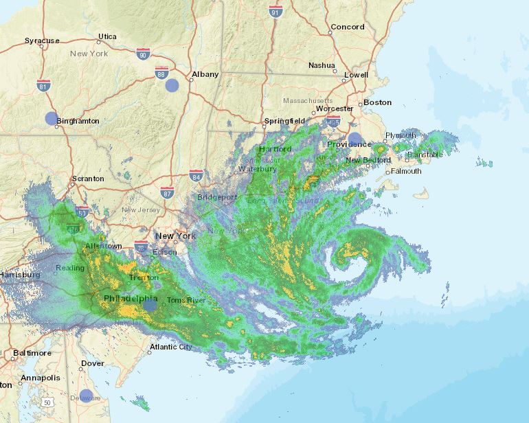
Hurricane Henri is already leaving his mark across southern New England, New York and New Jersey as heavy bands of rain in front of the storm are producing flash flooding. A record-setting 100mm of rain fell Saturday night at Central Park in NYC. The heavy rain has resulted in dangerous flash flooding, with numerous water rescues occurring overnight.

Early this morning, Henri was located 125km southeast of Montauk, Long Island, with 120km/h winds. The storm was moving north at 30km/h. Widespread watches and warnings remain in effect across the northeastern US. Winds and seas will continue to build along the coastal regions through the morning hours Sunday.

Long Island National Weather Service radar early Sunday morning showing the center of Henri southeast of Montauk Point.

Henri is forecast to make landfall either on eastern Long Island or Rhode Island, then move slowly inland towards southern New Hampshire. The storm is forecast to weaken while moving off to the northeast on Monday.

The only impact expected across southern Quebec will be clouds thickening form the southeast along with perhaps a stray shower or thunderstorm this afternoon and overnight. Our region will remain under the influence of a tropical air mass, with very humid conditions through Monday. Henri will produce rain and gusty winds across Atlantic Canada late Monday and Tuesday.

Saturday, August 21, 2021

Heat warning in effect for Montreal and the entire region

The high of 32.1C (90F) at Trudeau Airport Friday, missed the 1970 record by one tenth of a degree. We have a shot at beating both record highs this weekend. Humidex values reached 40C during the late afternoon hours, and will likely do so again on Saturday. A heat warning is in effect for the St. Lawrence Valley.

Heat Warning in effect for the St. Lawrence Valley, southern Quebec, eastern Ontario and the Champlain Valley of New York and Vermont. Stay hydrated, wear light clothing and avoid strenuous outdoor activities. Seek air conditioning if possible.

Hot and humid air has settled over southern Quebec and Ontario for the weekend, fueled by strong high pressure located off the Atlantic coast. This Bermuda high is pumping tropical air northward into our region. Adding to the moist, steamy air mass is the northward track of tropical storm Henri.

Saturday will be hazy and hot in Montreal with a high of 33C (91F) forecast and humidex/heat index values into the low 40s. Sunday will be similar, with a high of 32C (90F), but with some high clouds streaming northward form Henri, as the storm makes landfall on Long Island, New York and moves into southern New England. There is a risk of perhaps a few showers along the US border late Sunday as well as a wind shift to the northeast in the afternoon. At this time little other impacts are expected in Quebec, with Henri forecast to move northeast after landfall, well south of Montreal.

In terms of high temperatures for Montreal this weekend, we have a chance at exceeding the long-standing record highs for both Saturday and Sunday. The record high for both days was established in 1955, 32.8C Saturday and 30.6C Sunday.

Tropical Storm Henri

Henri was located 315km southeast of Cape Hatteras, North Carolina at 5am Saturday morning, with 110km/h winds. Henri is expected to strengthen into a hurricane on Saturday, while maintaining a northward track. Widespread watches and warnings have been posted for the northeastern US and southern New England including metropolitan New York City. Rainfall of up to 250mm, along with a storm surge of 3 to 5 feet is expected. The storm is expected to make landfall on central Long Island during Sunday afternoon. The center will then move inland across far western Massachusetts before moving northeast into Maine. The path of Henri will have to be watched closely to see what impacts if any we can expect locally. It appeared earlier in the week, that Henri was moving out to sea. Since then, each successive forecast model run has moved the storm closer and closer to an expected US landfall close to New York City.

Friday, August 20, 2021

Hurricane watch raised for southern New England

The official National Hurricane Centre forecast map of the projected path of tropical storm, soon-to-be hurricane Henri. Henri was located southeast of the Carolina coast on Friday morning, expected to intensify and turn towards the north over the next 24 hours. A hurricane watch has been raised for the southern New England coast. (NHC)

Tropical storm Henri, located 1255km south, southwest of Nantucket, Massachusetts early Friday morning, is forecast to become a hurricane over the nest 24 hours. The storm is currently moving west, northwest at 15km/h, and expected to turn towards the north on Friday around a ridge of high pressure located over Atlantic Canada. Henri will then take aim at southern New England and Atlantic Canada.

It has been 30 years since a hurricane made landfall in coastal New England. On August 19, 1991, hurricane Bob raced into southern New England resulting in several fatalities and billions of dollars in damage. Most of the weather from Bob remained southeast of Montreal, and this should also be the case with Henri on Sunday. Perhaps some gusty northeast winds and a few showers may make into extreme southern Quebec.

The National Hurricane Centre has issued a hurricane watch for portions of Long Island, New York, coastal Connecticut, Rhode Island and Massachusetts. Henri is expected to arrive late Sunday afternoon, but heavy surf and gusty winds will arrive well ahead of the center. At this time, Henri is expected to produce a storm surge of 2 to 5 feet over coastal New England and Long Island, with rainfall of up to 8 inches (200mm) possible. Coastal and fresh water flooding is likely. Wind gusts over 90km/h will likely spread well inland into southern New Hampshire and Vermont.

While strengthening is expected over the next 24 hours, a slow weakening will begin thereafter as Henri encounters much colder water in New England. As the storm approaches the coast on Sunday, it will likely be a minimal hurricane or perhaps even a strong tropical storm. Nevertheless, severe weather impacts are expected. Swells from Henri will begin reaching the coast over the next 24 hours, this includes portions of New Brunswick and Nova Scotia. The swells will produce dangerous rip currents from the Carolinas to Nova Scotia.

The storm will then impact Atlantic Canada and especially Nova Scotia on Monday, with heavy rainfall and gusty winds expected. The Canadian Hurricane Centre will release an update at 9am Friday morning.
It has been a busy week in the tropics, with three named systems. Fred is currently a depression over New Hampshire after producing deadly flooding along the storms path, especially in North Carolina. Hurricane Grace weakened to a tropical storm after moving across the Yucatan Peninsula on Thursday. Grace is expected to regain hurricane strength in the Gulf of Mexico today before hitting mainland Mexico in the wee hours Saturday morning.