Sunday, September 19, 2021

Near-perfect late summer weather

The harvest moon will light up the evening sky on election day Monday, rising at 7:55pm in Montreal The Autumnal Equinox occurs Tuesday at 3:20pm. eastern time, heralding the end to summer 2021. The weather will be as perfect as it can possibly be for late September in southern Quebec and Ontario.

Fall officially arrives on Wednesday afternoon at 3:20pm eastern time, and with the exception a few high clouds, summer will end with near-perfect weather. There really is not much to add, strong high pressure is in control of the weather across eastern Ontario and southern Quebec and into Atlantic Canada. Expect clear, warm days, with increasing warmth and gusty winds as the week moves along.

A weak front settled across the region early Saturday morning, but as with just about every cold front this summer, it moved across Montreal with little fanfare, just a drop or two of moisture. Skies quickly cleared out leaving us with a beautiful day, and a high temperature of 24C (76F). 

As a matter of fact, 24C looks like the magic number this week. Expect sunshine through Wednesday and perhaps even into Thursday, with high temperatures either side of 24C. Overnight lows will start off fairly cool, in the upper single digits for some locations, as I write the current temperature is 11C (52F) here on Ile Perrot. By the middle of the week, overnight lows will be very mild under southerly winds, in the upper teens. The normal high/low for late September in Montreal, is 18C (65F) and 8C (48F).

Last Wednesday morning, a line of strong thunderstorms put down a quick 10 to 20mm of rain across the city. However conditions remain rather dry, with only 38.2mm of rain falling this month at Trudeau Airport. The normal for the entire month should be 89mm. The longer nights does mean there is dew present most mornings, which is helping a little.

The next chance for precipitation will arrive by Thursday as a frontal boundary and upper level low move across the Great Lakes and into Quebec. We can only hope this system brings some real rainfall.

Friday, September 10, 2021

Hurricane Larry racing towards Newfoundland

A NOAA satellite image of hurricane Larry located southeast of Nova Scotia and south of Newfoundland Friday afternoon. (NOAA)

Hurricane Larry is expected to make landfall across southeastern Newfoundland late Friday evening. The once category 4 hurricane has been roaming the open waters of the Atlantic for over a week. Larry, now a category 1 hurricane with 130km/h winds, was located 750km southwest of Cape Race, Newfoundland at 2pm Friday afternoon. Larry was racing north, northeast at 60 km/h.

A hurricane warning is in effect for the entire Avalon Peninsula through Saturday morning. Tropical storm warnings are in effect across the Clarenville, Burin and Bonavista regions. Larry is a large hurricane, with hurricane force winds extending outward up to 150km from the center. Forecasters expect the worst of the weather in southeast Newfoundland, including St John's around midnight, lasting through 5AM Saturday morning. Wind speeds are expected in the 110km/h range with gusts up to 140km/h along coastal regions. Winds this strong are capable of knocking down trees and power lines, along with some structural damages. Residents are being urged to prepare for a strong storm through the overnight hours and expect widespread power outages.

Hurricane Larry will rapidly approach the Avalon Peninsula Friday evening while transitioning into a powerful post-tropical cyclone. The center will move towards Greenland on Saturday. (NHC)

Storm surge flooding is possible as well, with large waves accompanying Larry as it races northeast into the north Atlantic. Swells from Larry are already impacting coastal regions from North Carolina to Atlantic Canada. Rainfall from Larry will not be as significant as originally expected due to the rapid movement of the storm, with 30 to 50mm forecast.

Larry is expected to remain a hurricane through landfall tonight and then begin the transition into a strong post-tropical cyclone over the Labrador Sea on Saturday.

Wednesday, September 08, 2021

Much needed rainfall across southern Quebec

While recent rainfall is helping, water levels remain very low along the St. Lawrence River. This photo was taken last Thursday in Lachine showing just how low the levels are. The lack of rainfall this summer has created difficult and at times dangerous boating conditions in the rivers and lakes around Montreal. (ValleyWeather)

Since September 1st, approximately 25mm (1 inch) of rain has fallen at Trudeau Airport including just under 4mm today. That amount would not be news-worthy, except for the fact that only 36mm fell on the city during the entire month of August. The rain has been a blessing, helping to green things up a little and increase water levels just a touch on area rivers and lakes.

An absolutely spectacular photograph of a waterspout moving inland near Port Albert, Ontario. The photo was taken by storm chaser Mary Ann Williams on Tuesday afternoon. Widespread severe weather impacted southern Ontario along a cold front. @Stormymaryann

A slow-moving cold front is crossing southern Quebec Wednesday afternoon, accompanied by showers and a rumble or two of thunder. That same front produced widespread severe weather in the Huron-Perth and Grey-Bruce regions of Ontario on Tuesday afternoon. There were numerous reports of waterspouts on Lake Huron, as well as tornadoes and hail from Port Elgin to Saugeen Shores. Significant damage was reported to several homes, as well as numerous trees felled and widespread power outages. The front will once again kick up some strong thunderstorms Wednesday afternoon, but only south and east of Montreal across the Eastern Townships and into Vermont. 

We have an unsettled pattern ahead of us in southern Quebec, with a mix of clouds and sunshine Thursday and Friday and the risk of isolated showers or thunderstorms. Friday will be much cooler and dare I say fall-like, with high temperature struggling to reach 18C (65F). Saturday looks pleasant, with a high of 23C (73F) under sunny skies. Clouds and showers return for Sunday.

The forecast track of hurricane Larry will take the center near or over the Avalon Peninsula of southeast Newfoundland late Friday, with winds in excess of 120km/h. (CHC)
Hurricane Larry

Hurricane Larry was located 855km southeast of Bermuda early Wednesday afternoon, moving northwest at 20km/h, with 175km/h winds. Larry is expected to transition into a powerful post-tropical cyclone as the centre nears the Avalon Peninsula of Newfoundland late Friday afternoon. At this time the center is expected to pass near or over southeast Newfoundland, with a period of strong winds, heavy tropical rain and storm surge. Wave heights may reach as much as 15 metres in the Grand Banks. Swells from Larry are already impacting the US eastern seaboard and will arrive in Atlantic Canada over the next 24 hours. The swells and surge are creating very dangerous surf conditions along coastal beaches.

The Canadian Hurricane Centre continues to monitor the progress of Larry, and will likely issue warnings sometime Thursday for portions of southeastern Newfoundland.

Thursday, September 02, 2021

Historic flooding sweeps northeast US

Historic tropical rain fell on portions of the northeast Wednesday night, including New York City where widespread flash flooding occurred. Central Park set a new record, with 75mm (3.15 inches) of rainfall in just one hour. The previous record was set just last week during tropical storm Henri. (Anthony Behar/CNN)

After devastating the Louisiana Gulf Coast, what was left of hurricane Ida swept across the northeastern US on Wednesday, with historic flash flooding and tornadoes. The severe weather was responsible for at least 8 deaths in the metropolitan New York region and  neighbouring New Jersey. The water came fast and furious, with 125 to 225mm (5-9 inches) of rain falling in just a few hours.

The record setting tropical downpour had nowhere to go, with neighbourhoods flooded and homes swamped. Highways flooded rapidly and the New York City subway came to a halt in partially submerged tunnels trapping commuters. First responders were forced to make numerous rescues. A state of emergency has been declared in both New York and New Jersey.

Earlier in the day powerful thunderstorms produced large tornadoes over portions of Maryland and southern New Jersey. Numerous communities were impacted, with several homes destroyed. The death toll from Ida sits at 16. 

What is left of the system is located near Cape Cod early Thursday morning, moving northeast towards Nova Scotia. Rainfall warnings are in effect for portions of Atlantic Canada, with 40-60mm forecast along with embedded thunderstorms and gusty winds.

Wednesday, September 01, 2021

Welcome to meteorological fall

A NOAA satellite image taken Wednesday showing the remains tropical depression Ida over the northeastern US. With the exception of a few high clouds, most of the sensible weather will remain well south of Montreal and Quebec. Ida will likely spread rain into Atlantic Canada by Friday. After devastating the Louisiana Gulf Coast, Ida has produced flash flooding and tornadoes along the storms entire path through the Tennessee and Ohio Valleys. (NOAA)

Fall, at least according to meteorologists, has arrived. September 1st marks the the first day of meteorological fall, the celestial equivalent will arrive on Wednesday, September 22. So statistically speaking, the warmest three months of the year are behind us. It was an odd summer for sure, a rather coolish July, bookended by two scorching dry months and very little thunderstorm activity in Montreal.

Taking a brief look at August, it was hot and dry in Montreal. The average temperature was 23.6C (74.5F), well above the normal of 20.1C (68.2F). Total rainfall was 36.1mm, which is significantly below the long-term average of 94.1mm. For the year, Montreal has received 476.7mm of precipitation, which is 73% of normal to August 31. We managed two distinct heatwaves resulting in 13 days over 30C (86F). Dozens of new temperature, dew point and humidity records were established in August at Trudeau Airport.

We are off to an average start in September, with partly sunny skies and high temperatures expected in the low to middle 20s through Saturday. The dry weather will persist, with no precipitation expected until Sunday at the earliest.

A National Guard convoy rolls through the New Orleans suburb of LaPlace on Monday looking for victims of the fierce hurricane. (NOLA.com)
Hurricane Ida

The remains of Hurricane Ida, now a depression with 30 mph winds, are moving through the northeast US today and Thursday. All the weather associated with Ida will remain well south of Montreal, with partly cloudy skies expected this afternoon from the northern edge of the cloud shield associated with Ida. Ida is expected to produce heavy rain and flash flooding across portions of the northeast and southern New England, including metropolitan New York City. 

In Louisiana, the clean up is underway after Ida produced catastrophic wind damage and widespread flooding. Damage is estimated in the billions, with many homes destroyed and no running water available in many locations. This is especially true in the Parishes south of New Orleans towards the Gulf of Mexico. Over 1 million homes remain without power, with crews from 22 states arriving to assist in the restoration. The National Guard and FEMA are on the ground helping residents. All this is taking place as temperatures soar over 90F (32C), with heat index values over 100F (37C).

Sunday, August 29, 2021

Category 4 Hurricane Ida makes landfall in Louisiana with 240 km/h winds

Satellite image taken at landfall of powerful hurricane Ida, 12:55pm Sunday near Port Fourchon, Louisiana. (NOAA/NWS)

UPDATE 12:55 PM: Landfall of powerful category 4 Hurricane Ida at Port Fourchon, Louisiana with 150mph winds gusting to 165mph.

As expected Ida has rapidly strengthened overnight, reaching category 4 status over the last few hours. As of the 7AM advisory, Ida had 150mph (241km/h) winds and was moving northwest at 15 mph (24km/h). The storm continues to deepen over very warm ocean waters. Landfall is expected close to Grand Isle, Louisiana by late afternoon. The Hurricane Hunter aircraft have been entering the storm non-stop over the last few hours, relaying back vital information to forecasters at the National Hurricane Center.

Already this morning seas are building and surge is starting to impact coastal communities from Alabama to east Texas. Strong rain bands are already pivoting into the region, accompanied by torrential rain, gusty winds and isolated tornadoes. Thousands have fled inland, but the rapid arrival of the storm has meant many have remained sheltered in place. This is the first major test for the billion dollar levee system protecting New Orleans. The entire system was overhauled after the catastrophic failure and loss of live after Katrina on this date in 2005.

Ida is expected to generate a storm surge of up to 15 feet and over 20 inches (500mm) of rain. The storm will continue to strengthen until landfall. This is on ongoing story and I will provide additional updates today.

Saturday, August 28, 2021

Dangerous Hurricane Ida heading for Gulf Coast

A NOAA image of developing hurricane Ida southeast of the US Gulf Coast early Saturday. Ida is expected to become a major category 4 hurricane before arriving along the Louisiana coast late Sunday evening. Preparations are being rushed to completion today. (NOAA)

Hurricane Ida continues to strengthen in the southeast Gulf of Mexico early Saturday morning, forecast to become a major storm before reaching the Louisiana coast late Sunday afternoon. Ida will arrive 16 years to the date of infamous hurricane Katrina, now the benchmark for deadly hurricanes.

At 4am Saturday morning, Ida was located 825km southeast of New Orleans, moving northwest at 26km/h. Peak winds were at 130km/h (80mph), with Ida forecast to undergo rapid intensification on Saturday. Conditions are ideal for this strengthening, with extremely warm seas-surface temperatures as well a little wind shear, which can tear apart a storm.

Overnight, Ida forced evacuations along the western Cuba coast as the storm rapidly moved across the region with strong winds and torrential rains. The rain also spread across Jamaica and the The Cayman Islands.

The projected path of hurricane Ida over the next few days. (NHC)

Hurricane warnings are in effect for the central Gulf coast, with the impact zone stretching from east Texas to the Florida panhandle. The focus will be on central Louisiana near the barrier island of Grand Isle as well as the extremely vulnerable metro New Orleans. It was Katrina in 2005 that destroyed the levee system in New Orleans, inundating the city and killing thousands of residents.  

Evacuations are underway, with Ida expected to be near Category 4 status when the storm arrives on Sunday. Winds are expected to be in the 225km/h (140mph) range at landfall, along with a 4m (15 foot) storm surge. Rainfall will be epic along the track, with up to 500mm (20 inches) possible. 

While wind is often the focus of these powerful storms, the surge is what causes the most death and destruction. Storm surge is a wall of water pushed inland ahead of the center of the storm. Ida will have an impressive storm surge of between 10 and 15 feet. The surge ahead of Hurricane Katrina in 2005 was 25 feet along the Mississippi coast.

As I write this Saturday morning, evacuations are expanding rapidly across the Gulf coast as thousands flee inland. Once inland, Ida will weaken rapidly while meandering across the lower Mississippi Valley before moving off the middle Atlantic coast. Ida will become a big rainmaker with inland fresh water flooding expected. No weather from Ida is forecast at this time across southern Ontario or Quebec.

Sunday, August 22, 2021

Henri making landfall in southern New England Sunday

Heavy rain out in front of hurricane Henri, produced flash flooding in New York City on Saturday night. (New York Post)

Henri was downgraded to a tropical storm as of 7am with 70mph winds.

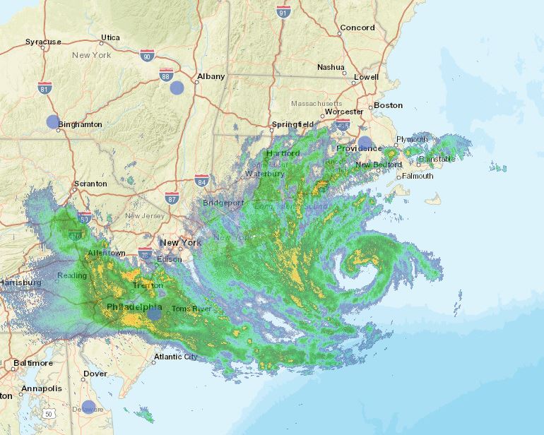
Hurricane Henri is already leaving his mark across southern New England, New York and New Jersey as heavy bands of rain in front of the storm are producing flash flooding. A record-setting 100mm of rain fell Saturday night at Central Park in NYC. The heavy rain has resulted in dangerous flash flooding, with numerous water rescues occurring overnight.

Early this morning, Henri was located 125km southeast of Montauk, Long Island, with 120km/h winds. The storm was moving north at 30km/h. Widespread watches and warnings remain in effect across the northeastern US. Winds and seas will continue to build along the coastal regions through the morning hours Sunday.

Long Island National Weather Service radar early Sunday morning showing the center of Henri southeast of Montauk Point.

Henri is forecast to make landfall either on eastern Long Island or Rhode Island, then move slowly inland towards southern New Hampshire. The storm is forecast to weaken while moving off to the northeast on Monday.

The only impact expected across southern Quebec will be clouds thickening form the southeast along with perhaps a stray shower or thunderstorm this afternoon and overnight. Our region will remain under the influence of a tropical air mass, with very humid conditions through Monday. Henri will produce rain and gusty winds across Atlantic Canada late Monday and Tuesday.

Saturday, August 21, 2021

Heat warning in effect for Montreal and the entire region

The high of 32.1C (90F) at Trudeau Airport Friday, missed the 1970 record by one tenth of a degree. We have a shot at beating both record highs this weekend. Humidex values reached 40C during the late afternoon hours, and will likely do so again on Saturday. A heat warning is in effect for the St. Lawrence Valley.

Heat Warning in effect for the St. Lawrence Valley, southern Quebec, eastern Ontario and the Champlain Valley of New York and Vermont. Stay hydrated, wear light clothing and avoid strenuous outdoor activities. Seek air conditioning if possible.

Hot and humid air has settled over southern Quebec and Ontario for the weekend, fueled by strong high pressure located off the Atlantic coast. This Bermuda high is pumping tropical air northward into our region. Adding to the moist, steamy air mass is the northward track of tropical storm Henri.

Saturday will be hazy and hot in Montreal with a high of 33C (91F) forecast and humidex/heat index values into the low 40s. Sunday will be similar, with a high of 32C (90F), but with some high clouds streaming northward form Henri, as the storm makes landfall on Long Island, New York and moves into southern New England. There is a risk of perhaps a few showers along the US border late Sunday as well as a wind shift to the northeast in the afternoon. At this time little other impacts are expected in Quebec, with Henri forecast to move northeast after landfall, well south of Montreal.

In terms of high temperatures for Montreal this weekend, we have a chance at exceeding the long-standing record highs for both Saturday and Sunday. The record high for both days was established in 1955, 32.8C Saturday and 30.6C Sunday.

Tropical Storm Henri

Henri was located 315km southeast of Cape Hatteras, North Carolina at 5am Saturday morning, with 110km/h winds. Henri is expected to strengthen into a hurricane on Saturday, while maintaining a northward track. Widespread watches and warnings have been posted for the northeastern US and southern New England including metropolitan New York City. Rainfall of up to 250mm, along with a storm surge of 3 to 5 feet is expected. The storm is expected to make landfall on central Long Island during Sunday afternoon. The center will then move inland across far western Massachusetts before moving northeast into Maine. The path of Henri will have to be watched closely to see what impacts if any we can expect locally. It appeared earlier in the week, that Henri was moving out to sea. Since then, each successive forecast model run has moved the storm closer and closer to an expected US landfall close to New York City.

Friday, August 20, 2021

Hurricane watch raised for southern New England

The official National Hurricane Centre forecast map of the projected path of tropical storm, soon-to-be hurricane Henri. Henri was located southeast of the Carolina coast on Friday morning, expected to intensify and turn towards the north over the next 24 hours. A hurricane watch has been raised for the southern New England coast. (NHC)

Tropical storm Henri, located 1255km south, southwest of Nantucket, Massachusetts early Friday morning, is forecast to become a hurricane over the nest 24 hours. The storm is currently moving west, northwest at 15km/h, and expected to turn towards the north on Friday around a ridge of high pressure located over Atlantic Canada. Henri will then take aim at southern New England and Atlantic Canada.

It has been 30 years since a hurricane made landfall in coastal New England. On August 19, 1991, hurricane Bob raced into southern New England resulting in several fatalities and billions of dollars in damage. Most of the weather from Bob remained southeast of Montreal, and this should also be the case with Henri on Sunday. Perhaps some gusty northeast winds and a few showers may make into extreme southern Quebec.

The National Hurricane Centre has issued a hurricane watch for portions of Long Island, New York, coastal Connecticut, Rhode Island and Massachusetts. Henri is expected to arrive late Sunday afternoon, but heavy surf and gusty winds will arrive well ahead of the center. At this time, Henri is expected to produce a storm surge of 2 to 5 feet over coastal New England and Long Island, with rainfall of up to 8 inches (200mm) possible. Coastal and fresh water flooding is likely. Wind gusts over 90km/h will likely spread well inland into southern New Hampshire and Vermont.

While strengthening is expected over the next 24 hours, a slow weakening will begin thereafter as Henri encounters much colder water in New England. As the storm approaches the coast on Sunday, it will likely be a minimal hurricane or perhaps even a strong tropical storm. Nevertheless, severe weather impacts are expected. Swells from Henri will begin reaching the coast over the next 24 hours, this includes portions of New Brunswick and Nova Scotia. The swells will produce dangerous rip currents from the Carolinas to Nova Scotia.

The storm will then impact Atlantic Canada and especially Nova Scotia on Monday, with heavy rainfall and gusty winds expected. The Canadian Hurricane Centre will release an update at 9am Friday morning.

It has been a busy week in the tropics, with three named systems. Fred is currently a depression over New Hampshire after producing deadly flooding along the storms path, especially in North Carolina. Hurricane Grace weakened to a tropical storm after moving across the Yucatan Peninsula on Thursday. Grace is expected to regain hurricane strength in the Gulf of Mexico today before hitting mainland Mexico in the wee hours Saturday morning.

Tuesday, August 17, 2021

Temperatures on the rise again across southern Quebec

A vehicle drives along a partially flooded coastal road Monday at Alligator Point, Florida. Tropical Storm Fred made landfall over the region Monday afternoon, with storm surge and fresh water flooding as well as isolated tornadoes. The storm was weakening south of Atlanta on Tuesday afternoon. Heavy rain is still forecast from the southeastern US into New York State. (Tori Lynn Schneider/Tallahassee Democrat)

While we may be past the peak of the summer season, the warm weather is not showing any signs of leaving just yet. After a less humid, pleasant weekend, temperatures and humidity are on the rise again. High pressure anchored off the southeast US coast is expected to pump warm, moist air northward over the next week or so. Helping in the northward trajectory of the tropical airmass, will be the remains of Fred.

Tropical Storm Fred moved inland along the Florida Gulf Coast near Cape San Blas late Monday afternoon. The storm dumped copious amounts of rain over portions of the Florida panhandle and southern Georgia, along with isolated tornadoes. Widespread flood watches and warnings are currently in effect from Georgia to New York state. As of Tuesday afternoon, Fred has been downgraded to a depression with 45km/h winds. The broad center was located 48km southwest of Atlanta. 

As this time it appears the bulk of the rainfall will remain south of Montreal. What we can expect is an increase in heat and humidity along with some scattered showers or thunderstorms through the weekend. High temperatures will once again approach 30C (86F), with overnight lows in the high teens and low 20s.

Despite all the humid weather we have experienced this August, most of the rain has avoided the metro region. To date, Montreal has received only 17.8mm of rain at Trudeau Airport on only four days in August. Hopefully some of the upcoming tropical moisture will find its way into our lakes and streams which are running exceptionally low.

The rain from Tropical Storm Fred will remain south of Montreal through Wednesday. (NOAA)

Tropical Storm Grace

Two more tropical systems have developed this week, Grace and Henri. Grace was located 40 km east of Montego Bay, Jamaica midday Tuesday. The storm dumped heavy rain across earthquake ravaged Haiti over the last 24 hours, with as much as 250mm falling. Flash flooding and landslides are possible across Haiti and the Dominican Republic as well as portions of southern Cuba. 

Grace is expected to intensify and become a hurricane within the next 24 hours as the center moves just south of The Caymen Islands. The storm will then take aim at the popular beach and resorts towns of the Yucatan Peninsula in Mexico. 

Meanwhile Henri was located 215km south, southeast of Bermuda, with 95km/h winds, and no threat to land at this time.

Friday, August 13, 2021

Cooler - less humid weather in Montreal this weekend

Thursday was another hot and sticky day in Montreal. Temperatures soared close to 30C early in the morning and then remained fairly steady as cloud cover developed. Cooler, less humid air will arrive behind a cold front on Saturday.
(Valley Weather Photo)

Heat warning in effect for southern Quebec

Friday will be the last day of our current heatwave. High temperatures since Monday have been between 30 and 32C (86 to 90F), with humidex values either side of 40C, in short it has been hot and humid. This was by far our warmest stretch of weather this summer. Fridays anticipated high of 32C will bring the total number of days over 30C in Montreal to 15. The record high for Friday is 33.3C set in 1947.

A cold front will arrive late this evening or overnight, along with scattered showers and thunderstorms. As was the case most days this week, the threat will be fairly low for severe weather, the storms will be hit and miss. There is still a chance some locations may receive heavy rain and gusty winds. On Saturday, high pressure will build into southern Quebec, along with clearing skies, much lower humidity and seasonal high temperatures around 25C (77F). The overnight period will be much more pleasant for sleeping, with lows near 15C (59F).

Slightly warmer, more humid weather will return for next week, with an increasing chance for precipitation.

Tropical Storm Fred

The tropics have been fairly quiet most of August so far, but there are signs that is about to change. Early Friday morning, tropical depression Fred was located 595 km southeast of Key West, Florida, with 55km/h winds. Fred is expected to strengthen today and reach tropical storm status. Tropical Storm Warnings have been issued for the Florida Keys and Florida Bay. The warnings will likely be extended along the west coast of Florida. Fred is following a path similar to that of Elsa earlier this summer, moving WNW at 16km/h, and forecast to make landfall in the Florida panhandle by late Sunday. Fred will be primarily a rain maker, with the threat for flooding, especially across northern Florida. 

Monday, August 09, 2021

Heat warning for southern Quebec and eastern Ontario

By the water will be the place to be this week as it was on Sunday along the St. Lawrence River near Lancaster, Ontario. (ValleyWeather Photo)

Heat Warning in posted for metro Montreal

A warm front is lifting north of the St. Lawrence Valley early Monday morning, accompanied by scattered showers and a rumble or two of thunder. Once the front clears the region, a very steamy, tropical airmass will be present with us through Friday. 

For that reason, Environment Canada has issued a heat warning for a large portion of southern Quebec and eastern Ontario. Hazy, hot and even smoky conditions are possible, along with an afternoon risk of showers or thunderstorms. High temperatures will rise into the low 30s, with humidex values approaching 40C. Overnight lows will be near 21C (70F). Cooler, less humid air arrives by next weekend.

Until then exercise caution during the daytime hours especially. The risk is greatest for young and old, those with chronic illnesses and those working outdoors. Drink plenty of water and seek out air conditioned spots during the hot afternoons if at all possible. Never leave your pets or anybody for that matter unattended in a vehicle for any period of time in these extreme temperatures.

Heat warnings are posted when the combination of elevated temperatures and humidity push the humidex values over 40C (104F).  Temperatures this high can pose an elevated risk of heat stroke or heat exhaustion. Stay cool!

Friday, August 06, 2021

Steamy smoky forecast for Montreal

Another smoky sky over Montreal on Friday morning. Smoke from Ontario and Manitoba fires will make for poor air quality through Saturday. A smog warning has been posted for Montreal. The AQI (Air Quality Index) for Montreal at 6am Friday morning ranged from 85 to 113 across the island. This is at a level considered unhealthy for sensitive groups. (Valley Weather Photo)

Smog Warning in effect for metro Montreal. Expect poor air quality today as a result of smoke from Ontario and Manitoba wildfires. Conditions should improve on Saturday.

After a rather cool and at times dismal looking July, the warmest weather of the summer thus far is about to descend on Montreal. Most of July was dominated by a northwest flow aloft in the atmosphere. The result was only one 30C high temperature in Montreal, and only 6 such days since June 1st. We will likely add to that total over the next week or so as warm, humid air is pushed northward along the eastern seaboard into southern Quebec.

We will also have to deal with some smoke from western wildfires. It what has become the summer of the wildfire, we have already had several episodes of dense smoke and will likely have several more before August ends. Hundreds of fires are burning across North America, with the main concentration from B.C. into northern Manitoba and northwest Ontario. That smoke will drift over southern Quebec over the next 24 hours, prompting a smog warning for Montreal and portions of western Quebec and northeast Ontario. Southerly winds should help push the smoke out of our region on Saturday.

The airmass will become rather humid, with the chance for showers and thunderstorms each afternoon from Saturday well into next week. The high temperature in Montreal on Thursday was just shy of 30C (86F). The current forecast calls for temperatures in the high 20s and low 30s through next week. Overnight lows will be very mild, close to 20C (68F) in the city, slightly cooler across the off-island suburbs. This will be the warmest stretch of summer 2021 so far.

Sunday, August 01, 2021

Warmer weather on the horizon for Montreal

A waterspout over Lake Huron. The constant battle of airmasses across the Great Lakes, Ontario and Quebec, has resulted in an increase in tornadoes and severe weather across both provinces this summer. To date, 26 tornadoes have been confirmed in Ontario, and 9 in Quebec. (ClickOnDetroit.com)

July is sadly over. Typically the warmest month of the year for Montreal, this July failed on many levels. Most of Canada has been torrid this summer, with thousands of temperature records falling, especially across western Canada. Such was not the case across eastern Ontario and western Quebec, as a stubborn northwest flow of air prevailed. Numerous strong thunderstorms, tornadoes and waterspouts have also occurred in Ontario and Quebec this summer as a result of the frequent cold fronts and constant battle of airmasses. Meanwhile it has not rained in Vancouver and parts of British Columbia in over a month. 

July ended with an average temperature of 20.7C (69F), below the normal of 21.2C and well below last July when we managed 24.3C (76F) at Trudeau Airport. Montreal had only one day over 30C on July 15, when the mercury reached 30.2C. In contrast, that number was 14 days in July 2020, including the top temperature of 36.1C (97F). Only 9 days this month managed to break the 27C (80F) mark compared to 25 of the 31 days in 2020. Despite the many cloudy, cool days, most of the rain fell south and west of Montreal, with a monthly total of 60.4mm, most of that falling on three days.

So what does all this mean for August? The trend right now is for temperatures to recover slightly. That will begin this week as the Bermuda high moves slightly west towards the US east coast and begins pumping warm and humid air northward. A frontal boundary will be responsible for showers and thunderstorms Sunday, especially south and west of Montreal. Temperatures will again be rather cool for the middle of the summer, with highs reaching close to 20C. Southern Quebec should have clearing skies on Monday, with a decent week ahead. Mainly dry, fair conditions are expected, with highs reaching through the upper 20s to near 30C in Montreal by next weekend.

Monday, July 26, 2021

Another smokey forecast for Montreal

The sun filtered through smoke from western wildfires over Ile Perrot on Sunday afternoon. Smog warnings are in effect for Monday, but conditions should improve by Tuesday. (ValleyWeather)

Very poor air quality will greet you as you head out the door on Monday morning. The smoke is drifting southeast for wildfires in northwest Ontario and Manitoba. The Air Quality Index (AQI) is in the moderate range already in Montreal, with Cornwall, Ontario unhealthy with and AQI of 154 at 6AM. The smoke will be most dense through the middle portion of the day before a cold front arrives late afternoon. Smog warnings are in effect for the southwestern portion of Quebec, with Air Quality Advisories for eastern Ontario.

An area of dense forest fire smoke is expected to produce very poor air quality over Ontario and southern Quebec on Monday. (FireSmoke.ca)

On Sunday, several rounds of thunderstorms produced a vivid lightning display to our southwest in the late evening, but little else in Montreal. Earlier in the day the warm front dropped 10-15mm of rain across southern Quebec. 

Today's frontal boundary will likely produce more scattered showers and thunderstorms, before cooler air arrives for Tuesday. The smoke will also be forced southeast of Montreal, with much better air quality expected on Tuesday.

Temperatures have been cooler than normal this month, and that trend will persist. We have only had one day at Trudeau Airport over 30C this month, rare for July, especially in 2021 when so much of the country is sweltering. The high on Tuesday will only be 21C (70F), well-below the normal high 26C (79F). The balance of the week look similar, with highs ranging from 21 to 24C (70 to 75F) and low temperatures close to 16C (60F).

Thursday, July 22, 2021

Quiet weather to end the week in Montreal

There were dozens of reports of trees down across eastern Ontario and extreme southern Quebec from strong thunderstorms Tuesday afternoon. (CBC Photo)

After a few days of rather strong thunderstorm activity and poor air quality, the weather will calm down as we end the work week. High pressure is trying to clear the skies in Montreal Thursday afternoon, but a few high cirrus and fair weather cumulus clouds still prevail. Skies should clear out this evening followed by mainly sunshine for both Friday and Saturday. Temperatures will be close to normal values for late July, with highs of 26 to 28C (79 to 83F), and overnight lows around 18C (65F).

A series of disturbances will arrive by Sunday, along with an increase in humidity and the risk of showers and thunderstorms. Some of the storms may be on the strong side late Sunday in the St. Lawrence Valley. The weather will be warm and muggy Sunday, with a high near 27C (81F).

The week so far has been rather active across the country once again. Fires continue to char interior portions of British Columbia as temperatures remain very hot, with little precipitation. A state of emergency in in effect in B.C. Firefighters from Quebec are on the ground and in the air in B.C., as hundreds of fires burn.

The heat has spilled into Alberta and Saskatchewan as well. Meanwhile in Ontario and Quebec, the week started with dense smoke and haze from those western wildfires. The air quality was extremely poor. That came to an end for the time-being on Tuesday afternoon, as a potent cold front pushed the toxic air south into the the northeastern US.

Lightning sparked an intense fire that destroyed two homes in the Fabreville section of Laval Tuesday afternoon. (CTV News/Francis Ethier)

Lightning sparks Laval house fire

That aforementioned cold front produced lines of strong thunderstorms Tuesday afternoon. There were numerous reports of hail and wind damage from eastern Ontario into southern Quebec, northern New York and New England. Numerous trees were blown down along with some structural damage, especially south of Montreal along the US border. 

In the Fabreville district of Laval, north of Montreal, lightning stuck a Hydro pole around 6:15pm igniting a fire that spread to several homes. Two homes were completely destroyed, with damage estimates at over one million dollars. It took 50 Laval firefighters more than two hours to bring the blaze under control. Heavy rain also fell with the thunderstorms, with 26mm falling on Ile Perrot in less than an hour. Thankfully no injuries were reported from any of the storms in Ontario or Quebec.

More isolated storms occurred Wednesday afternoon, with torrential rain and small hail reported, once again from Laval through the central portion of the Island of Montreal. No damage was reported.

Tuesday, July 20, 2021

Gusty thunderstorms should sweep away the smoke & haze

Smoke and haze from hundreds of western wildfires is obscuring the skies from Ontario into southern Quebec and across the Great Lakes and New England. The smog, haze and smoke has lowered air quality across a wide area. The smoke has also resulted in spectacular sunsets and a reddish/ orange moon last evening over eastern Ontario and southern Quebec. Photo: Gary Bussiere
 If you thought the sky was odd looking the last few days, you would be right. Smoke from over 800 wildfires burning across western Canada, has produced blood red moons and spectacular sunsets across eastern North America. The smoke has also diminished air quality, resulting in advisories and smog warnings for a large portion of Ontario and Quebec including metro Montreal and Ottawa. Not only is the smoke limiting visibility and blocking out the sun, it has made breathing a challenge for many. Smog can impact asthmatic children and people with respiratory ailments or heart disease. Those who suffer are being 

The smoke, haze and smog should lift later this evening after the passage of a potent cold front from Ontario. The front is already producing thunderstorms across Ontario early this afternoon, and they will spread south and east into Quebec later today. A few may be strong, with gusty winds, hail and heavy rainfall. 

Conditions have been warm and humid as well, with a few scattered storms rumbling about on Monday, but very little rainfall in Montreal. This afternoons storms will be a little more widespread, with showers persisting into the overnight. Wednesday is expected to remain cloudy in the St. Lawrence Valley, along with showers, and much cooler. Daytime highs will be in the lows 20s. The smoke and haze should dissipate as well for at least the short-term period.

Friday, July 16, 2021

Strong tornado injures 9 in Barrie, Ontario

Barrie, Ontario OPP describe the damage as catastrophic in one neighbourhood after an EF-2 tornado with 210km/h winds touched down Thursday afternoon.
(Anthony Farnell/Global)

In what seems to be a rather common theme in Canada this summer, another strong EF-2 tornado, with estimated winds of 210km/h, slashed across the southern part of Barrie, Ontario Thursday afternoon. The tornado touched down around 2:30pm in the Mapleview Drive neighbourhood, travelling nearly 5km and cutting a swath of major to catastrophic damage 100 metres wide. 

The damage was similar to what was observed in Mascouche, Quebec last month. Roofs were torn from homes, cars overturned, trees and power poles flattened and in two instances, homes were removed completely from their foundations. Barrie Simcoe Police and EMS reported 9 injuries, 4 of those of serious nature. Crews arrived immediately to begin debris removal and reconnect power. At the height of the storm over 4000 were without power in the region.

Residents of Barrie, Ontario are no strangers to tornadoes. On May 31, 1985, an EF-4 storm with 330km/h winds tore through the community killing 8. It remains one of the deadliest tornadoes in Canadian history.

The storms greatly diminished in intensity before arriving in southern Quebec overnight, with only scattered rain and gusty winds. A wind gust to 71km/h was reported at Trudeau Airport at midnight with the passage of one storm cell. Eastern Canada has been warm and humid this week, making the atmosphere ripe for strong storms. More thunderstorms are forecast today across eastern Quebec into Atlantic Canada.

Night becomes day on Ile Perrot early Tuesday morning as strong thunderstorms swept across southern Quebec. Vidivd lightning illuminated the sky across the island of Montreal through 1am. (ValleyWeather Photo)

The current weather pattern will continue through the upcoming weekend and into next week. Ridging in western Canada will allow for a prolonged and potent heatwave, while troughing in the east will result in more clouds than sun, humid conditions and the ever-present risk for showers and thunderstorms. Highs in Montreal will be near normal through the period, 27C (81F) for daytime highs and around18C (65F) for lows.

Monday, July 12, 2021

Unsettled muggy week ahead for Montreal

The summer sun reflecting off high cirrus clouds produced a vivid halo in the sky on Sunday afternoon in Montreal. (Photo Linda Shore - The Suburban)

While it won't be the dog days of summer by any stretch, the upcoming week will be warm and humid, and rather uncomfortable at times. A persistent southwest flow of warm, moist air originating from the Gulf of Mexico will be pumped northward by a Bermuda high located off the east coast. Occasional disturbances in the atmosphere will deliver enough lift to produce scattered showers and thunderstorms right through the week in the St. Lawrence Valley. While the weather will be dry for large portions of the upcoming week, the threat for rather heavy downpours at times will persist as well.

As far as temperatures go, highs will be in the middle to upper 20s, with lows in the upper teens. Factoring in elevated humidity levels, humidex readings will rise into the low 30s. Basically typical July weather for Montreal. As I have stated many times this year, we need the rain. The storm system late last week delivered most of the heavier precipitation south of Montreal region, as did a similar system last evening. So far Montreal has received 19.2mm of rainfall in July, the long-term average for the entire month is 89.3mm. We can however make up the difference rather quickly this week, with a few well-timed thunderstorms. 

On Sunday, many residents across southern Quebec observed a very well-defined halo around the sun. This was caused by the reflection of the sun off ice crystals in the high thin cirrus clouds that had advanced across the island of Montreal. The sun was also veiled by smoke located very high up in the atmosphere that was being generated by widespread forest fires burning from B.C. into northern Ontario and transported aloft by the strong prevailing westerlies.

The brutal British Columbia forest fire season continues unabated, with 41 new fires started in the last week alone. Quebec is sending assistance to B.C. to help battle the blazes. (B.C. Wildfire Service)

The high heat of the last few weeks has taken a toll in British Columbia. To date 983 fires have occurred in 2021, up 41 in the last week alone. The majority of the fires, 45.1 percent, have been started by lighting. SOPFEU, the agency responsible for forest fire prevention in Quebec, will be sending manpower and equipment to assist the British Columbia Wildfire Service. Quebec already has aircraft helping in Ontario.

Feeling Hot, Hot Hot

The scorching heat of June, the warmest month ever recorded on the planet, has persisted into July. On Friday, Death Valley, California recorded the second hottest temperature ever recorded on the planet, and the warmest since 1931. The high was 54.4C (130F), tying Death Valley with the record set in Kebili, Tunisia on July 7, 1931. This was just behind the warmest of all-time, 134F (56.7C), also set at Death Valley on July 10, 1913. Lytton, B.C. established the new Canadian heat record on June 30, 2021 at 49.6C (121.3F).

Thursday, July 08, 2021

Soaking rain for Montreal and eastern Canada

A frontal boundary will deliver 25 to 50mm of rain to southern Ontario and Quebec on Thursday. Meanwhile tropical storm Elsa will bring heavy rain and wind to the eastern portion of the province.

A low pressure trough pushing eastward across Ontario and Quebec will deliver heavy rain and thunderstorms to both provinces on Thursday. The bulk of the rain in Montreal will fall this afternoon into the overnight hours. A few of the thunderstorms may be strong, with heavy downpours the main threat. Most areas are expecting 25-35mm of rain, but over 50mm is possible locally across the St. Lawrence Valley in Ontario. We remain in a rather sharp deficit as far as rainfall goes, so the threat for flooding is minimal. However there could still be some ponding of water on roadways. 

Temperatures will be cool today across southern Quebec, in the 15 to 20C range (60-70F). Warmer weather returns for the weekend along with a spike in humidity levels starting Sunday and persisting into next week.

Further east across the lower St. Lawrence and into New Brunswick, the aforementioned trough will tap into tropical moisture moving along the Atlantic coast from Elsa. Portions of central New Brunswick could see up to 100mm (4 inches) of rainfall. 

Early Thursday morning, Elsa was located 240km southwest of Raleigh, North Carolina. Elsa was still a tropical storm, moving northeast at 30km/h, with winds of 65km/h. Tropical storm force winds are expanding over a wide area, reaching out 185km from the center of the storm.

Tropical storm Elsa is forecast to move from the Carolinas into Atlantic Canada over the next 24 hours. (Canadian Hurricane Centre)

Elsa has been delivering heavy rain along her path along with isolated tornadoes. The center of the storm will move across the middle Atlantic states on Thursday and into southern coastal New England tonight. There may be s light increase in intensity once the center moves back over open water Thursday afternoon. On Friday, Elsa will approach DownEast Maine, Nova Scotia, New Brunswick and Prince Edward Island as a potent post-tropical cyclone. Heavy rain has prompted widespread flood watches across southern New England. Watches and warnings will likely be extended into New Brunswick and Nova Scotia later today. Along with the heavy rain, gusty winds up to 70km/h are possible.

Wednesday, July 07, 2021

Tropical Storm Elsa to remain south of Montreal

Heavy rain from tropical storm Elsa deluged Key West, Florida on Tuesday. Close to 100mm of rain fell across south Florida, with some flooding reported but otherwise only minor damage. (The Key West Citizen)

Early Wednesday, tropical storm Elsa, the little storm that could, was located 55km west of Cedar Key, Florida in the eastern Gulf of Mexico. After dumping heavy rain on Cuba and claiming at least three lives across the Caribbean region, Elsa moved into south Florida late Tuesday. For a few hours, the storm regained hurricane strength, with 120km/h winds before weakening slightly early Wednesday.

As of 8am Wednesday morning, Elsa was moving north at 22km/h, with 105km/h winds. The system continues to produce very heavy rain, coastal flooding and gusty winds from the central Florida coast into southern Georgia. Elsa should make landfall in the Big Bend region later this morning, before moving northeast into the Carolinas and Virginia. Rainfall will be the big story with Elsa, with 75 to 150mm of rain possible along the path.

By late Thursday the storm will likely move back over the open water of the western Atlantic before a second landfall on Cape Cod and a third into Nova Scotia. Montreal will likely remain on the northern edge of the system, with some gusty northeast winds 20-40km/h funnelling down the St. Lawrence Valley. Steady rain is forecast for southern Quebec on Thursday, but this will come from a frontal boundary moving across the Great Lakes and New England. No phasing between the boundary and Elsa is expected at this time. Some southern Quebec locations may see over 25mm of rain on Thursday. Temperatures as a result of the clouds, precipitation and northeast winds will remain very cool for July, only 16C (61F).

Conditions will improve in Montreal for the upcoming weekend, with clearing skies Saturday and high temperatures into the upper 20s.

The path of tropical storm Elsa will take her from the Gulf Coast of Florida into the middle Atlantic region, New England and eventually Atlantic Canada by the weekend. (NHC)


Friday, July 02, 2021

Wild weather from coast to coast to coast in Canada

A horrifying image from a video taken by a resident evacuating Lytton, B.C. during a fast-moving firestorm Wednesday afternoon. The small community northeast of Vancouver was devastated by fire after setting the all-time Canadian high temperature record on three consecutive days. (CBC News/2 Rivers Remix Society/Vimeo)   

It has been an eventful weather week across Canada, with historic heat in the west, tornadoes in Ontario and some drought-busting thunderstorms in southern Quebec. Starting locally, thunderstorms produced 25 to 75mm (1-3 inches) of rain across southern Quebec on Wednesday. The heavy, sudden tropical downpours produced ponding of water on roads and even some damage from flash flooding across several lower Laurentian communities. Dozens of roads were washed out affecting at least a dozen municipalities including Mont Tremblant. Damage aside, the rainfall was a blessing in what has otherwise been and extremely dry spring. Over 50mm of rain fell in the Montreal region over the last week, bringing the June total to 103.6mm. The storms also produced strong winds, 91km/h at Trudeau Airport.

Torrential downpours late Tuesday and Wednesday dropped over 75mm of rain across parts of the lower Laurentians. In Lac Supérieur, northwest of St Jerome, dozens of residents were evacuated and roads were washed out. (Photo: Municipality of Lac-Supérieur via Twitter)

As we close out the week, an upper level low will bring September-like weather to southern Quebec for Friday. Cool northeast winds and scattered showers will keep temperatures in the teens today. Warmer and more humid weather will return as we head though the weekend and into early next week. Temperatures will rise to near 30C in Montreal by Tuesday along with more thunderstorms.

Western Heat & Fire

The historic and deadly heatwave has taken a toll on B.C., Alberta and Saskatchewan. There have been hundreds of heat-related fatalities. The electric grid has taken a beating with widespread power outages reported. The tinder-dry conditions have created an extreme fire danger. On Wednesday afternoon, a fast moving wildfire ravaged the small town of Lytton, BC just hours after they had set the all-time Canadian high temperature record of 49.6C (121F). The town of 250 located northeast of Vancouver in the Frasier Canyon was 90 percent destroyed by the ferocious fast-moving firestorm. Aided by strong, shifting winds and fuelled by days of excessively dry hot weather, the fire virtually moved unchecked across the valley, despite the heroic efforts of BC Wildfire Service. An evacuation order was issued shortly before the fire arrived, giving residents minutes to leave. Most fled to the neighbouring communities of  Merritt, Lillooet and Boston Bar.

Hurricane Elsa

The earliest "E" named storm on record for the Atlantic Hurricane season is Elsa. Elsa became a hurricane early Friday morning, with 120km/h (75mph) winds. The storm was located 65km west of Barbados early Friday, moving west northwest at 44km/h. Elsa is expected to remain a strong tropical storm or Category 1 hurricane over the next few days as she carves a path across the Caribbean and passes between Haiti and Jamaica over the weekend. By early next week, the tropical system will be approaching the eastern Gulf of Mexico and the west coast of Florida.

Sunday, June 27, 2021

Heat Warning in effect for Montreal

Find ways to stay cool this week, as Canada swelters from coast to coast.

Heat Warning in effect for metro Montreal.

Mascouche Tornado CLICK HERE

What a weather week it has been across Canada. From drought to tornadoes and historic heat, we have seen it all. I will begin with the current weather, it is a very warm and muggy Sunday morning in Montreal, with the temperature already at 24C (76F) at 6am. We are on the way to a high of 32C (90F), with humidex values approaching 40C. Overnight lows will remain well-above 21C (70F) in the city. Environment Canada has posted a heat warning for the region through Tuesday. Warm and humid air is being forced northward by high pressure located off the middle Atlantic coast.

A strengthening Bermuda high will pump tropical air into southern Quebec this week. High temperatures combined with elevated humidity levels will make it feel closer to 40C. Meanwhile western Canada is baking in in historic heat. (AccuWeather.com)

Along the periphery of that heat bubble, showers and thunderstorms have been firing up. Some of the storms were strong on Saturday, with tornadoes reported in central Ontario, into Michigan and Illinois. In Quebec it was much need rainfall, with 21.8mm at Trudeau Airport, 17mm here on Ile Perrot. Every drop helps, but we remain well-below normal in the precipitation department, a drought that stretches back to winter. Saturday's rainfall brings the monthly total in Montreal to 47.2mm, still 50 percent of normal for June. This comes after an extremely dry April and May.

Monday's deadly tornado in Mascouche, was one of four to impact the province that day. The total for the season has already reached 8 in Quebec, we normally only have 5 for the entire year. (CTV News Montreal)

Quebec Tornado Outbreak

The Northern Tornadoes Project out of Western University in London, Ontario has completed their preliminary assessment of Monday's severe weather outbreak in Quebec. The strong thunderstorms produced 4 separate tornadoes. The first occurred south of Montreal at Saint-Valentin near the US border. The tornado touched down at 335pm with 115km/h winds, and EF-0 on the Enhance Fujita Scale. The second tornado was the deadly storm that swept across Mascouche, with widespread severe damage and one fatality. It was an EF-2 with estimated winds of over 180km/h. Between 4 and 5pm two more tornadoes were observed at Saint-Celestin (EF-0, 115km/h winds) and Saint Narcisse-de-Beaurivage (EF-1, 150km/h winds).

Historic Heatwave

 An historic heatwave is gripping portions of western Canada and the Pacific Northwest. Temperatures on Saturday soared into the upper 30s and middle 40s. Over 50 high temperature records were broken in B.C., including 43.2C (110F) at Lytton. Temperatures will be even warmer on Sunday and Monday, with a high of 47C forecast for the B.C. interior. If that occurs it will become the warmest temperature ever recorded in Canada. The current record dates back to the dirty thirties, when Yellow Grass, Saskatchewan reached 45C (113F) on July 5, 1937.

The heatwave has even impacted the large coastal cities, with Victoria and Vancouver reaching into the middle 30s. Portland, Oregon recorded there warmest day ever on Saturday, reaching 108F (42.2C) surpassing the  benchmark of 107F set in 1981.

The heatwave is forecast to persist all week as hot high pressure builds in from the deserts of the southwest US. The heat will spared east into Alberta and Saskatchewan as the week prevails. 

Sunday, June 20, 2021

Strong thunderstorms for the first day of summer

Lightning illuminates the sky over Ile Perrot during recent thunderstorms. There have not been to many storms this season to date, but a frontal boundary is poised to generate severe thunderstorms Monday afternoon across southern Quebec. Be alert to rapidly changing weather conditions if you have any outdoor activities planned for Monday. (Valley Weather Photo)

Elevated risk for severe thunderstorms Monday afternoon in Montreal

Summer officially arrives at 11:32 PM Sunday evening, and right on cue, a warm and humid airmass will arrive across southwestern Quebec. Sunday was a sunny and pleasant day, with temperatures topping out in the high 20s, 29C (85F) here on Ile Perrot, along with low humidity. The evening will remain dry and mild, with clouds on the increase after midnight. Lows will remain warm, in the upper teens.

A warm front will lift across the region during the pre-dawn hours Monday, accompanied by scattered showers and perhaps a rumble of thunder. Skies will then partially clear Monday morning, with strong, gusty southwest winds briefly transporting tropical air into the St. Lawrence Valley. Temperatures will rise quickly into the upper 20s and low 30s across the region. Humidity levels will rise as well, making for a muggy day. The airmass will become quite unstable, with plenty of energy to fuel developing storms.

A frontal boundary is expected to move into the region late in the day, with strong to severe thunderstorms developing in advance of the trough. The storms are expected to form across eastern Ontario by 2pm and move east-northeast along the boundary into southern Quebec. At this time, there is an elevated risk of severe weather. The main threat will be strong gusty winds up to 100km/h, but large hail, torrential downpours and dangerous lightning are possible as well. A severe thunderstorm watch will likely be issued by Environment Canada some time Monday morning.

If you have any outdoor plans on Monday, keep and eye to the sky. This is especially true if you will be out on the open water. The threat for severe weather will diminish into the evening hours Monday. Skies will partially clear on Tuesday, along with cooler, less humid conditions. High temperatures will be in the low 20s for Montreal.

Monday, June 14, 2021

Much needed rain for southern Quebec and Ontario

A spectacular sunrise, taken through the annular solar eclipse last Thursday morning on Ile Perrot. Much needed rain is forecast to start this week along with muggy weather. (Valley Weather Photo)

The moderate drought that has stretched throughout the spring has left much of the region desperate for rainfall. Overnight, thunderstorms produced around 8mm of rain in Montreal, but the monthly departure from normal remains at around 75 percent below the long-term average. This after only 15 to 25 percent of normal precipitation fell last month, including the driest May on record for Montreal. More showers and thunderstorms are forecast this afternoon into the evening hours as a frontal boundary moves across the St. Lawrence Valley. Some of the storms may be strong, with heavy rain and small hail the main threat. The weather will be warm and muggy, with highs near 25C (77F).

More showers are expected on Tuesday with slightly cooler temperatures around 22C (72F). Over the two day period, up to 25mm (1 inch) of rain is possible, with more in heavier thunderstorms. 

As the dry weather persists over a large portion of the province, SOPFEU has had to seek assistance from B.C., Alberta and New Brunswick. Several teams have arrived in Quebec to help battle 16 active fires burning across the province. (SOPFEU Photo) 

Quebec is currently extremely dry, with the Montreal region and the Laurentians under extreme fire conditions. SOPFEU, the provincial department responsible for forest fire prevention has called in assistance from B.C., Alberta and New Brunswick. At present, there are 16 active fires burning in the province. A widespread burn ban was put in place last Thursday across 12 regions of the province. This year there have already been 357 fires, well above the ten year average of 204. The fires have consumed over 7000 hectares (17,300 acres).

The lack of rain has had a serious impact on agriculture across the region. Locally on ÃŽle Perrot, the stress on vegetation due to the lack of precipitation can be seen just about everywhere. Grass is turning brown and some trees are dropping leaves. Municipalities on Ile Perrot as well as Vaudreuil-Dorion have watering restrictions in place. In the case of Notre-Dame-de-L'ÃŽle-Perrot where I live, we are only permitted to water for two hours between 8 to 10pm on alternating even/odd days, depending on your address. Check with your municipality for any restrictions. Fines can be quite high and from what I understand are being enforced.

It will take a few months of above normal rainfall to begin to narrow the deficit in Montreal. Unfortunately we are heading into our typically hottest, driest weather of the year, highly dependent on thunderstorm activity.