Freezing Rain continues......
NO SCHOOL BUS SERVICE
Temperatures in Eastern Ontario remain below freezing this morning. At 6am Cornwall/Massena was -2, Ottawa was -5 and Kemptville was -3. All areas are reporting freezing drizzle. Any untreated areas will be slick. SLOW DOWN. Temperatures will very slowly move above freezing by noon. The storm system will move from upper Michigan to North Bay today. Heavy snow continues on the west side of the storm, North Bay has had 39cm while Pembroke in the upper Ottawa Valley is close to 20cm. My rain gauge is frozen so I am not sure how much freezing rain and sleet has fallen in Kemptville, but the ground is covered and glazed. School Bus service for the City of Ottawa and Lanark, Leeds & Grenville, SD & G and City of Cornwall is cancelled today.
Monday, January 30, 2006
Sunday, January 29, 2006
Winter weather returns
For the third weekend in a row, record highs are being followed by winter weather. Kemptville and Ottawa both broke records yesterday hitting 8C and 6C respectively. Now one of the most poorly, albeit difficult forecast weather events is unfolding. Winter Strom Warning are in effect for Eastern Ontario and Southern Quebec. Precipitation, only about 12 hours late is now falling, and will slowly spread east and north as the night moves on. Snow, from 10-20cm will fall along the Ottawa River, with less south. Freezing Rain is expected from Montreal to Brockville, with 2-6mm of ice. Travel is becoming poor and very changeable. Postpone till tomorrow if at all possible. The same is true for upstate New York and Vermont.
For the third weekend in a row, record highs are being followed by winter weather. Kemptville and Ottawa both broke records yesterday hitting 8C and 6C respectively. Now one of the most poorly, albeit difficult forecast weather events is unfolding. Winter Strom Warning are in effect for Eastern Ontario and Southern Quebec. Precipitation, only about 12 hours late is now falling, and will slowly spread east and north as the night moves on. Snow, from 10-20cm will fall along the Ottawa River, with less south. Freezing Rain is expected from Montreal to Brockville, with 2-6mm of ice. Travel is becoming poor and very changeable. Postpone till tomorrow if at all possible. The same is true for upstate New York and Vermont.
Tuesday, January 24, 2006
 The Roller Coaster ride moves on.....
What has become the normal pattern for the winter of 2005-06 continues across most of the country. Cold air, if any, has been short lived, for a day or two at best, punctuated by strong cold fronts that stir up the winds and snow. The photo above shows the 15cm of snow falling across North Grenville last Saturday, January 21. The day before it was 9C in Kemptville and 6C in Ottawa, record highs. Today, Tuesday, January 24, we reached 3C, but snow and gusty winds are forecast tonight. As a matter of fact Winter Strom Warnings are in effect for Jefferson and Lewis counties in New York State for up 30cm of snow, I-81 will be poor tonight and Wednesday. Same is true for the areas around Georgian Bay and Lake Huron. Eastern Ontario and west Quebec will see between 2-7cm of snow with winds between 40-60km/h and temperatures dropping by midday Wednesday.
Leftover snow from the 15cm on Saturday - ValleyWeather Pictures

Wednesday, January 18, 2006
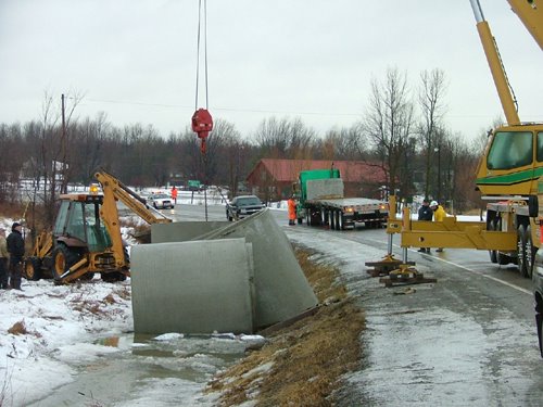 The clean up scene on County Road 43 near Hallville after
 5 trucks hit the ditch during Freezing Rain this morning...
Photo Dan Reid
What a morning.....
Ice and heavy rain snarl traffic
Heavy rain and freezing rain blasted the area icing roads and causing numerous accidents in and around Ottawa and Kemptville this morning. The Queensway in Ottawa was down to one lane in many areas with ice and massive puddles the main culprit. Elsewhere the OPP closed Highway 43 at Hallville after several trucks plowed into the ditch. The roads were ice packed at the time. River Road south of the Airport was also closed by city police.
Kemptville received 38mm of rain as of 2pm, Ottawa 26mm. Half of that was frozen during the overnight period. About 7 hours of freezing rain occurred in area. The Seaway fared much better as the temperatures warmed up just after midnight limiting the freezing rain to about 3 hours.
The storm was also responsible for gusty winds, over 80km/h along the Lake Ontario shoreline. Snowsqualls are expected around Lake Huron and south into Watertown, New York. Some snow is forecast tonight along with temperatures below freezing.
Trying to keep up with the ice in Kemptville this morning.
ValleyWeather Photo

All School Busses Cancelled
Heavy Rain a threat now.....
The freezing rain overnight was enough to cancel all busses in our area this morning including Lanark, Leeds and Grenville, Stormont, Dundas and Glengarry and City of Ottawa. We received a good 5-10mm of ice that has coated everything outside. Roads are a mess with hard packed ice in the center lanes. In addition even though it is above freezing the rain that is falling on any untreated surface is still freezing on contact.
Our attention now shifts to the threat of minor flooding and then strong winds. A Wind Warning is in effect for the St. Lawrence Valley on both sides of the border in Ontario, Quebec and NY. Winds will gust form 50-90km/h beginning this afternoon. In addition Heavy Rain Warnings have been posted for Southern Quebec. From 30-50mm of rain is possible, enough to cause flooding where catch basins are blocked. Area rivers will have to be closely monitored. Roads are terrible this morning....slow down......
Tuesday, January 17, 2006
The Polar Roller Coaster continues
More Freezing Rain....
Not again, I hate these winters.......lets change this pattern please. The snow to rain to snow deal is on again in our region. It has been a month of ice and more ice. A Freezing Rain Warning has been posted again for Eastern Ontario including Leeds & Grenville Counties and metro Ottawa for tonight. Look for snow to begin in the area around sunset and change to freezing rain by midnight. It will be icy overnight and into tomorrow before the temperatures warm up at the surface or cool off aloft. This will taper any precipitation to showers or flurries. The other item of interest with this storm will be the strong winds. As the storm moves from the Midwest up across Lake Huron it will increase winds, first out of the east then the south and southwest. They may gust to warning criteria on Wednesday, that is up to 90km/h in upstate New York and into Ontario.
Saturday, January 14, 2006
Flash Freeze Expected
This is an ALERT to anyone living in eastern Ontario, Western Quebec, Northern New York and Vermont. The weather is about to change dramatically today. A strong Arctic boundary will pass through the region by noon-6pm today. Temperatures will fall from present values of 6 to10C down to below freezing rapidly. In addition strong winds will develop from the north at 60km/h and rain will change to snow. Computer models are having a tough time dealing with how much will fall. It looks like 5-20cm across the area. Amounts aside it will be nasty driving.
A Flash Freeze Warning is in effect for Eastern Ontario.
A Winter Strom Watch is in effect for Northern New York and Vermont.
Of Note: A Winter Strom Watch is also in effect for Southeast Saskatchewan. A developing Colorado Low is expected to bring Freezing Rain to the area tonight.
Friday, January 13, 2006

Severe Weather across Southeast US
Despite the calendar saying January, severe weather has broken out across the Gulf Coast from Louisiana to Georgia. At least two tornadoes and one fatality have been reported as of 2pm.
Much Colder this weekend
Highlights.....
~Very mild today Ontario and Quebec
~More rain in Vancouver with risk of mudslides
~Flooding rains across New England and eastern New York
~Much colder in Ontario and Quebec tomorrow
~Foggy on the Prairies this morning Assiniboia and Gravelbourg
The storm system that will be bringing us the rain tonight, in some cases as much as 25mm (1 inch), will pull off to our east Saturday. The big question by area forecast offices today is how quickly will the cold air wrap in behind the storm on Saturday. The Burlington office is calling for gusty north winds and 8-13cm of snow Saturday with temps plunging towards -10C. The Ottawa office is looking at the same for wind and temperature but only 2-4cm of snow.
In any event the rain of tonight will begin to freeze up by midday Saturday. That means roads will become very icy and with 60km/h winds and dropping temperatures in the Ottawa and St. Lawrence Valley, whatever snow falls will blow around. Travel will be poor from noon to midnight tomorrow.
Special Weather Statement NY/VT
Flood Watch NY/VT
No Warnings for Quebec/Ontario
Thursday, January 12, 2006
Storm likely this weekend....
Good morning everyone......Enjoying the mild weather in Ontario and Quebec I trust! It has been quite a spell. I want to go skating on The Rideau Canal in Ottawa, but it has only been open for a couple of days. The very mild weather will continue into Friday...However,.....Don't just like however's in weather!
Surface low pressure is expected to develop in the Midwest and along the US east coast early Friday. The result will be very mild air, plus 9 for Montreal and Ottawa early Friday along with rain developing into Friday night.
As the storm system along the coast becomes the primary low colder air on very strong north winds will be drawn into the St. Lawrence Valley and northern New England. The rain will change to snow early Saturday morning and continue all day. It is very early in the forecast period, but confidence is growing that we will see a storm. In any event it will be colder. Prepare yourself for winter weather this weekend.
Of Note...Vancouver is going for the rain record set in the 1950's. If it rains through this weekend, and it should, over 50mm expected today, then they will set a new record. So far 29 days straight and counting. They can have it! I will take the mix of seasons any day. Besides how can anyone live where there are no thunderstorms!!!!
Tuesday, January 10, 2006
 Mild weather continues...
Quake rattles Seaway
Sorry for my absence at the start of this weather year. It has been a little busy and the normal January blues have settled in.
It has however been very mild. Temperatures across most of the country have been above normal. The cold air is trapped across the high Arctic. Two storms have fooled forecasters this past week. The first surprise was last Thursday. About 16cm of snow fell in Kemptville, we were only expecting a few cm with freezing rain afterwards. The second storm on Monday took a similar track with another 10-15cm of snow in the area. While Freezing rain Warnings were issued, it never materialized in our area.
The ValleyWeather picture above is the heavy accumulation of snow in Kemptville.
We are currently watching a storm developing in Arkansas that could give lots of problems to the Ottawa valley tomorrow. While mild air is expected to eventually stream into our area, the last two systems have shown us that this does not always go as planned.
At any rate freezing rain is expected to change to rain early Wednesday morning.
An Earth Quake rattled the St. Lawrence River Valley 61km southwest of Montreal. The quake registered 3.7 on the Richter Scale. No reports of any damage.
Below is a sun pillar last Friday, January 6 in North Grenville - ValleyWeather Pic

Wednesday, January 04, 2006
More ice for the valleys
It has been a rough start to 2006 for many across North America and indeed the world. My thoughts and prayers are with those in the West Virginia mine tragedy, the news is not good this morning, as well as those suffering in the California floods and the wildfires in the southern plains.
The weather has been equally bizarre with a very mild flow of Pacific air dominating the North America. This has allowed very warm tropical air to stream northward. Temperatures have been almost summerlike from Texas to Florida. In Ontario and Quebec we are just north of the really warm air. The unfortunate thing about that is it leaves our areas exposed to freezing rain and fog. This morning a Freezing Fog Advisory is in effect for the St. Lawrence Valley of NY/Ontario, and the Conn. Valley of Eastern Vermont.
A low pressure area developing in the Midwest will slide down the St. Lawrence Valley tonight leaving Montreal and Ottawa on its northern side. Snow and sleet will develop today and continue into Thursday. By the time it ends 10cm should fall. It won't be a big storm, but it will be messy. No warnings are out yet, but the system should be watched.
Subscribe to:
Posts (Atom)