Sunday, February 27, 2022

Snow squalls expected across southern Quebec Sunday

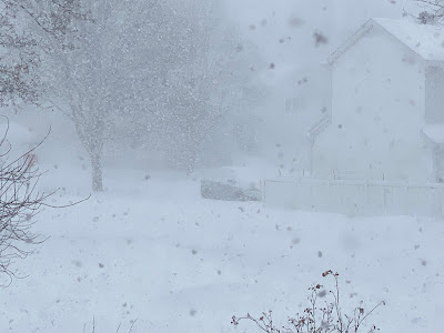
Friday's storm produced heavy snow and blowing snow in Montreal, with numerous accidents reported around the region. Visibility was greatly impacted through the middle portion of the day as seen in the photo above taken on LaSalle Blvd in Verdun. Photo: Peter Storey

A Snow Squall Watch is in effect for a large portion of eastern Ontario and southern Quebec for Sunday including metro Montreal.

Another in a series of low pressure systems will impact the region today. The low is a rather weak Alberta Clipper, with limited moisture, but a strong cold front producing a wide range in temperatures. Light snow will develop early Sunday morning a the low moves across southern Quebec. Gusty southwest winds are expected as well, up to 50km/h at times, producing some blowing snow.

By the noon hour, squalls should begin to develop across Ontario moving southeast into Quebec. Brief periods of heavy snow with near-zero visibility are expected. Winds will shift to the northwest and gust up to 60km/h. This is a similar situation to last Saturday, where squalls produced numerous travel issues with several major accidents. Travel with care today, and expect highly changeable weather.

Temperatures will be mild today, reaching -1C (30F) before the frontal passage. They will tumble late this afternoon and this evening, down to -19C (-2F) by Monday morning, with windchill values in the mid minus 20s.

In terms of accumulations, expect a general 3-5cm for most locations, with more in the most persistent squalls.

Heavy snow falling on Île Perrot Friday afternoon. Between 15 and 20cm fell at most locations in southern Quebec (ValleyWeather Photo)

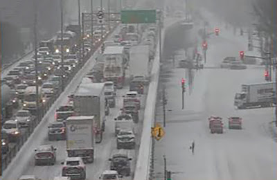
Friday's storm delivered 10 to 20cm of snow on the region, the most at Mirabel with 23cm, the least, as per usual, at Trudeau Airport where apparently only 11.2cm fell. I measured 15cm here on Île Perrot, with 15cm also in Laval, and on the South Shore. The snow fell quickly, reducing visibility at times to zero. Several major multi-vehicle accidents were reported, with one involving 20 vehicles on Highway 20 between Les Cèdres and Coteau-du-Lac. Another closed Highway 40 at Riguad. 

Similar conditions occurred in northern Vermont and New York. A 30 vehicle crash resulted in one fatality and several serious injuries on Interstate 89 near Milton, Vermont. The highway was closed for nearly 10 hours.

Thursday, February 24, 2022

Another wave of snow and cold forecast for Montreal

The snow on Friday is expected to hide the layers of ice coating most parking lots and driveways after 15mm of freezing rain and sleet fell on the Montreal region Wednesday night. 

Another winter storm, the third in less than a week is set to impact southern Quebec and Ontario on Friday with 5 to 15cm of fresh snow expected. Winter weather advisories are in effect for all of southern and eastern Ontario, with winter storm warnings in place across New England and New York. No warnings have been issued for Montreal at this time.

There is still a layer of ice on the ground in many places after Wednesday nights storm went through, which will makes things challenging with the new snow arriving. Wednesday's storm produced nearly 15mm of freezing rain and sleet, with very little warm air making it into Montreal. The temperature only nudged above the freezing point for a few hours early Thursday morning, before a strong cold front pushed across the region, with a peak wind gust of 88km/h at Trudeau Airport, and rapidly falling temperatures back below freezing. This resulted in standing water refreezing quickly.

This is setting the stage for a much colder weather system on Friday. Low pressure will deepen as it passes well south of Montreal, close to the New York City metropolitan region and into the Atlantic. Southern Quebec will be on the northern edge of the storm, with 5 to 10cm expected in the city and 10 to 15cm south towards the US border. The snow will begin early Friday morning and taper off late in the day. We are also expecting strong northeast winds of 30-50km/h to accompany the snow along with cold temperatures. The high is forecast at -11C (12F) for Montreal. The snow will be very fine and blow around quite easily. Expect poor travel conditions all day Friday.

Last Saturday's snow squall activity made driving dangerous across southern Quebec. More snow squall activity is expected this Sunday afternoon as an arctic cold front plows through the region. (ValleyWeather Photo)

Another round of snow squalls expected

Skies will clear out early Saturday morning, but any sunshine will be short-lived as another system arrives late in the day. Low pressure will pass near Montreal on Sunday with somewhat limited moisture, but drag a potent arctic front through the region during the afternoon hours. At this time it looks like a repeat of last Saturday, with dangerous snow squalls developing. They will be brief and isolated, but produce periods of strong winds, very heavy snow and poor visibility. Expect a general 2 to 5cm of addiotnal snowfall. Keep this in mind if you have any travel plans to end the weekend. Last weeks squalls produced quite a few serious accidents across southern Quebec and into Ontario and northern New England as well.

Tuesday, February 22, 2022

Freezing Rain Warning posted for Montreal

Freezing rain warnings are in effect for a large portion of eastern Ontario and southern Quebec today and tonight. Freezing rain should start in Montreal by late this afternoon.

Another messy winter storm is set to impact southern Quebec over the next 24 to 36 hours. Low pressure over the American Midwest will move into the Great Lakes and down the St. Lawrence Valley on Wednesday. In advance of the storm, colder air has settled back into Montreal. Temperatures early Tuesday morning are either side of -10C (14F).

Deep moisture will begin to stream northward later today, overriding the cold air at the surface. The result will be a few hours of freezing rain, starting this afternoon in eastern Ontario and the Ottawa Valley and spreading north and east into Quebec. Several hours of freezing rain are expected, with 5 to 10mm of ice accretion. Expect very slippery roads and sidewalks as well as the risk for isolated power outages in areas the see the longest duration of freezing rain such as Ottawa and Quebec City.

It has been a rather busy weather week in Montreal. On Saturday, wicked snow squalls crossed the region, with rapidly falling snow and wind gusts over 70km/h. Visibility was reduced to zero at times as shown above on Ile Perrot. Numerous accidents and road closures resulted across southern Quebec. (ValleyWeather Photo)

Temperatures will rise above freezing in Montreal overnight, as warm as 8C (47F) in areas along and south of the St. Lawrence River. Any freezing rain will change to showers in Montreal. A trailing cold front will follow on Wednesday, dropping temperatures just a quickly, down to -10C by late in the day. Winds will become quite strong on Wednesday, gusting up to 60km/h at times. Any remaining precipitation will taper off to flurries.

Another winter storm will slip south of the region on Friday, with a general 5 to 10cm of snow expected at this time for Montreal.

Friday, February 18, 2022

Snow day in southern Quebec

Schools are closed and traffic is at a standstill in may parts of Montreal Friday morning, after nearly 20cm of snow and ice fell overnight.

A potent winter storm has resulted in heavy rain and snow along with rapidly dropping temperatures over the last 36 hours. Highways are in very poor shape Friday morning, icy and snow covered. Numerous accidents have been reported in the Montreal region. Nearly every school board in southern Quebec has opted for snow day today, with more than 18cm of snow falling overnight in Montreal.

The change in weather was quick after a spring-like day on Thursday, featuring record breaking warmth for most of us. The high at Trudeau was 6.6C (44F), just shy of the record of 6.8C (44.2F) set in 2011. Here on Ile Perrot and across the off-island suburbs to the west, the high reached a balmy 9C (49F).

From deep puddles to ice and snow in just a few hours on Ile Perrot. The temperature at my home reached 9C on Thursday, but was down to 0C by 9pm last evening. More snow is on the way for the weekend. (ValleyWeather Photo) 

Late last evening a cold front crossed the St. Lawrence Valley, with rain mixing with sleet and freezing rain around 9pm and changing to snow shortly afterwards. The snow was heavy overnight, but has become lighter this morning and should end by noon. Storm totals are very impressive, with 27.6mm or rain falling in Montreal, followed by at least 20cm of snow. The temperature has dropped all the way to -10C (14F) as of 8am Friday.

The storm in question is over northern Maine this morning moving east, while the cold front has shifted into southern New England. High pressure will briefly clear skies this afternoon, along with steady or cooling temperatures, down to -15C (5F) tonight. On Saturday, a weak low pressure area will skirt across southern Quebec with light snow expected and windy conditions. Another 5cm of snow is expected for Montreal.

A very active weather pattern is expected next week, with moderating temperatures, and more mixed precipitation likely.

Wednesday, February 16, 2022

Multifaceted winter storm to target southern Quebec

Another spectacular February sunset in Montreal, the calm before the storm.

A special weather statement is in effect for the entire region as a winter storm develops over the next 24 to 48 hours.

A rather complicated winter storm featuring rain, flooding, strong winds, record high temperatures and eventually a flash freeze with heavy snow, will impact southern Quebec beginning Thursday. Much warmer air is streaming into the St. Lawrence Valley early Wednesday morning, allowing temperatures to finally rise after a 72 hour period of arctic air. The high Wednesday will be 4C (39F) under cloudy skies after low temperatures in the minus teens in Montreal.

Developing low pressure is expected to move northeast from the southern US along a cold front that is expected to move into our region late Thursday. The storm will pass just south of Montreal during the wee hours Friday morning. In advance of the cold front, a strong push of very warm air will result in record breaking high temperatures for many of us in southern Ontario and Quebec. The forecast high for Montreal on Thursday is 8C (46F), the record for the date is 6.8C (44F) set in 2011. 

Despite the record warmth forecast for Thursday, there may be a fresh 10 to 15cm of snow on the ground in Montreal by Friday morning. (AccuWeather.com)

Rain is forecast to develop on Thursday, with as much as 15 to 25mm for many locations. The heavy rain, mild temperatures and melting snow will lead to some localized flooding concerns. Strong southerly winds will develop on Wednesday afternoon, gusting up to 50km/h in Montreal, and 90km/h in the Richelieu Valley.

By late in the day Thursday, cold air will begin to filter into eastern Ontario and southern Quebec changing the rain to snow, with a period freezing rain possible for many locations including Ottawa and Montreal. Winds will become strong once again, backing to the northwest 30 to 50km/h. Temperatures will rapidly fall below freezing, down to -10C (14F) by Friday morning. The snow may be heavy at times with 10-15cm possible for many locations. Strong winds will cause blowing snow, and rapidly falling temperatures will turn any standing water to ice.

All this will be highly dependant on the track of the low pressure area and the timing of the cold front. The forecast is subject to change and as I said is quite complicated with plenty of moving parts. Weather warnings will likely be needed for several regions.

Saturday, February 12, 2022

Flash Freeze Warning - colder weather returns

A flash freeze warning is in effect for Montreal.

Expect rapidly dropping temperatures to produce icy travel conditions over the next few hours across southeastern Ontario and southwestern Quebec.

 A flash freeze warning has been issued for all of eastern Ontario and southern Quebec through early afternoon. A strong cold front currently moving across the Ottawa Valley, will pass through Montreal and southern Quebec late this morning into the early afternoon hours. 

Temperatures fall rapidly behind the front, with any standing water freezing quickly. Close to 4mm of rain fell overnight along with plenty of melting snow. Roads will become very slippery in hurry, so if you have travel plans exercise extreme caution. 

The current temperature here on Ile Perrot is our high for today at 4C (39F). Ottawa has already dropped below freezing, down 3 degrees in the last hour, along with a burst of heavy snow. The arctic airmass is spreading southeast quickly. Winds will shift from the southwest to west, gusting up to 60km/h ushering in the frigid temperatures.

The temperature will drop in Montreal down to -8C (18F) by late afternoon, and -20C (-4F) by Sunday morning. Sunday will be sunny, but bitterly cold, with a high of only -13C (9F) and windchill readings in the minus 20s.

Thursday, February 10, 2022

Frigid air returns to Montreal for Super Bowl weekend

A beautiful picture of Maison Nivard-De Saint Dizier or "The Old Stone House" as we called it while growing up in Verdun, living directly across the street on LaSalle Boulevard. The photo was taken by Peter Storey during the snowstorm last Friday morning. Montreal measured only 14.6cm of snow during the storm, far below early expectations. Other parts of southern Quebec measured as much as 25cm.

February has started off rather mild across southern Quebec, with only two days of below normal temperatures so far, and 5 days with temperature at or above the freezing point. This is a far cry from the frigid month of January, that featured 17 days colder than -20C (-4F) in Montreal, and a monthly average of only -13.5C (7.7F), 4 degrees below the long-term average. Snowfall was meager however as our rather tame winter moves along. Only 41cm fell at Trudeau Airport, the seasonal total sits at 94.8cm.

A series of weak systems will dominate the wether through Friday, with periods of showers or flurries and very mild temperatures. The high on both Thursday and Friday will approach 4C (40F). No significant accumulations are expected, but with nighttime temperatures at or slightly below freezing, there may be a few slick spots on area roads. 

A strong cold front is forecast to cross the St. Lawrence Valley by midday Saturday, ushering in an arctic airmass to end the weekend. A period of gusty winds and perhaps some snow flurries is expected along the front. However the big news will be the drop in temperatures. The mercury in Montreal will be above freezing early Saturday morning, but plummet down to -22C (-8F) by Sunday morning. Both Sunday and Monday should be fair in Montreal, but frigid, with daytime highs around -15C (5F) and overnight lows in the low minus 20s. A slight breeze will only add to the cold.

Temperatures will moderate by the middle of next week, as another storm system moves across the Great Lakes and west of Montreal. It appears southern Quebec will be on the warm side of the storm, with a mix of snow and rain expected at this time. 

Wednesday, February 02, 2022

Long duration snowfall expected in Montreal

A special weather statement is now in effect for metro Montreal, with 10 to 20cm of snow expected through Friday morning. The commute in Montreal on Thursday will be impacted as snow, falling temperatures and gusty wind are forecast.

Widespread weather warnings and advisories are in place from Ontario to Atlantic Canada including Montreal, as a winter storm approaches the region.

Wednesday turned into a spectacular weather day, with the mildest air so far this year. High temperatures around the Montreal region warmed between plus 4C and 6C (39-43F) under partly cloudy skies. Unfortunately, the mild weather is not going to last much longer. A strong cold front is moving across Ontario, changing rain to snow as it progresses southeast. Temperatures fall rather quickly behind the front, along with gusty northwest winds and steady snow.

Quebec's own Groundhog, Fred la Marmotte, saw his shadow today in Val-d'Espoir, predicting six more weeks of winter weather. That will become a reality quickly tonight as mild air retreats to the southeast and an arctic cold front arrives in Montreal. Rain will change to snow after midnight, and temperatures will plummet to -13C by Thursday night.

The cold front will approach the Montreal region overnight, settling across central New York and New England on Thursday. Rain will develop this evening in Montreal, changing to snow after midnight and persisting through the day on Thursday. On Thursday, low pressure will move along the front, with the snowfall picking up in intensity late in the day. In all, 10 to 20cm of snow is forecast from Montreal south to the US border and along the St. Lawrence Valley into Ontario. Temperatures will fall on Thursday from early highs near 0C (32F) down to -8C (18F) by late afternoon. Gusty northwest winds of 20-40km/h will make it feel much colder, and produce areas of blowing snow. Flurries are expected to persist into Friday.

Nicknamed the Groundhog Day storm, this system is far reaching, with weather warnings posted from Texas to Atlantic Canada impacting millions. Already today, heavy snow and freezing rain has created dangerous travel conditions across the southern plains into the Great Lakes. The snow has now moved into southwestern Ontario.