Thursday, July 28, 2016

Large hail pounds the Saguenay region of Quebec

Widespread damage occurred in the Saguenay region of Quebec on Wednesday, after baseball-size hail pounded the area. (TWN Photo courtesy Anne-Julie Belley)
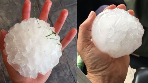
 A fierce hailstorm caused widespread damage across the Saguenay region of Quebec on Wednesday, July 27. Hail as large as 8cm in diameter fell in L'Anse-Saint-Jean, 2 to 5cm in La Baie and 2 to 4cm in Bagotville. The hail was part of a series of severe thunderstorms that swept across most of central and eastern Quebec, as well as northern Maine and New Brunswick. The storms were fueled by persistent hot and humid weather. Strong winds also accompanied the thunderstorm cells, knocking down trees and power lines. Widespread damage to homes and cars was reported as a result of the hail.

HOW DOES HAIL FORM?
Hail develops when strong updrafts in thunderstorms carry raindrops high into extremely cold regions of the atmosphere. Typically the storms in question are towering in nature, with cloud heights in excess of 30,000 feet. The raindrops freeze into balls of ice. The hailstone grows by colliding with super-cooled water droplets in the cloud. These freeze on contact with the evolving hailstone. The hail will be lifted multiple times into the upper portion of the thunderstorm, adding a layer of ice each time. Hail falls to the ground when the ice becomes too heavy for the updraft to maintain it, or the updraft weakens. Hail can be driven into the ground, cars, homes and people, by very strong winds that accompany the thunderstorm. The more severe the storm, the larger the hail. The hail can also merge with other stones, creating awkward and dangerous shapes. Hail has been know to cause widespread million-dollar damage. The largest hailstone reported in the US was in Vivian, South Dakota on June 23, 2010. It was 8 inches (20cm) in diameter, weighing in at 1 pound 15 ounces (878 grams). In Canada, the largest stone fell at Cedoux, Saskatchewan, on August 27, 1973. The hailstone was 11.4cm in diameter (4.5 inches), and weighed 290 grams (0.6 pounds).

Hail can damage windows and rip the siding from homes. (NOAA Photo)
Montreal often records small hail during summer storms. However, on May 29th, 1986, and on the same date in 1987, the city had major hailstorms. The hail measured up to 8cm (3 inches) in diameter and destroyed numerous trees and gardens. Damage was reported to homes and cars as well. The 1986 storm alone produced estimated insurable losses in excess of $70 million. I lived in southern Saskatchewan from 1997 to 2000 and witnessed many large hailstorms. One particular storm in 1998, left the roads covered in deep hail, and also damaged my car. It was before the digital era, so the photo lives in a box somewhere... and I will find it someday.

Wednesday, July 27, 2016

Lightning really does strike the same place twice

Like a giant lightning rod, the CN Tower in Toronto is struck 75 to 80 times each year. (blogTO Photo)
6:30 AM: Another warm and humid day is forecast for Montreal today, with a high of 28C (83F), along with scattered thunderstorms.

It is often said that lightning will not strike the same place twice. This is a rather important and life- threatening myth. Over the weekend, a picture of the Empire State Building in New York City being struck by lightning was circulating on social media. It got me thinking, how often does such a tall building get struck? The answer is 25 lightning strikes, on average, each year, up to as many as 100 times. The CN Tower in Toronto, being taller, is struck an incredible 75 to 80 times each year. A series of 52 grounding rods, running the length of the building and six metres below the surface, prevents the structure from being damaged. Each rod is 56cm thick. For the most part, the strikes are spread out over the thunderstorm season. However, on August 24, 2011, the CN Tower was struck 52 times in less than 90 minutes. So as you can very well see, lightning can and does strike the same location often.

This video-still of the Empire State Building being struck by lightning was taken by a tourist on July 23. (Weather.com)

Several weeks ago, I wrote about lightning safety so I won't go into that here. Simply put, there is no safe place outdoors. When thunder roars, go indoors. We are half-way through what has been a hot and humid summer across most of North America, with frequent thunderstorms. Lightning-strike data is rather difficult to come by in Canada, but the United States has already recorded 21 fatalities. Sadly, this puts them on a pace to achieving a much higher total than that of the last few years. Since 2008, the message had been getting out, with fatalities down from nearly 50 annually to under 30. Here in Canada, we average 10 fatalities a year, along with multiple injuries. The problem is a global concern. Just last month, within a few days, over 80 people were killed from lightning strikes during monsoon rains across India.

Monday, July 25, 2016

Another round of thunderstorms for Montreal

Rapidly developing thunderstorms produced torrential rain and flooding on L'Ile Perrot, Saturday, July 23. (ValleyWX)
Hot and humid weather took a one-day break on Sunday after Saturday's wicked weather. Strong thunderstorms rapidly developed on Saturday afternoon north of Montreal, and moved southeast across southern Quebec and into upstate New York and Vermont. The storms produced 25mm (1 inch) of rain here on L'Ile Perrot in under one hour. The result was flooding on numerous roads. Such was the case as well across other parts of Montreal. Some roads, especially ramps and viaducts on and off Highway 40, had to be closed until the water receded. The same cluster of storms dropped hail up to 2cm and produced winds in excess of 100km/h across Valleyfield and Vaudreuil and south of the city into the Townships. Tornado warnings were even issued southeast of Montreal, with several of the storms showing signs of rotation. Numerous trees and power lines were knocked down. South of the border, strong winds left several boaters requiring rescue on Lake Champlain. The wind also knocked out power to thousands in Vermont, some still in the dark this morning. One fatality was reported in Vermont.

Searing heat and humidity across a wide portion of Canada this July has resulted in numerous rounds of severe thunderstorms. The photo above is from my good friend in Moose Jaw, Saskatchewan (Dayna Smith-Short)
This morning, the heat and humidity are building once again, as a warm front approaches from Ontario. Showers and isolated thunder will give way to partly sunny and muggy weather through mid-afternoon. Temperatures will rise rapidly to around 30C (86F). A cold front will cross the area late in the day, with another round of robust thunderstorms. Some of the storms, like Saturday, may have heavy rain and small hail. Skies should clear after midnight, with a warm and dry Tuesday expected. The low tonight will be around 20C (68F), with the high Tuesday near 27C (81F).

Friday, July 22, 2016

Another sultry summer day for Montreal and Ottawa Valley

The heatwave in the central portion of the United States continues to periodically spill into Ontario and Quebec.
Heat warnings and special weather statements remain in effect from Environment Canada for southern Ontario and Quebec today. The combination of very warm temperatures, along with the high humidity, is creating rather steamy weather from Montreal to Ottawa and Toronto. Temperatures on Thursday reached the low to middle 30's across many location of eastern Canada including 31C (88F), here in Montreal, and 34C (94F) in Toronto. A few showers and thunderstorms overnight in Quebec only added to the elevated humidity. The temperature dropped no lower than 22C (72F) early Friday morning in Montreal, and we are already up to 27C (80F) as of 9:30 here on L'Ile Perrot.

Giant baseball size hailstones fell in central Saskatchewan this past week. A tornado was also reported near Davidson, Saskatchewan on Tuesday, July 19. (CBC Saskatchewan)
What you see is pretty much what you get, as southern Quebec will remain on the northern edge of a ring of fire in the central US. A massive dome of hot high pressure remains centered over the Midwest, with a rather strong and prolonged heatwave underway there. Temperatures in those regions have been in the 90's to 100F (34 to 37C). Along the edge of this system are periodic ripples of low pressure and frontal boundaries giving a break from the heat, but also showers and thunderstorms. Some of the storms have been very strong, with large hail and even tornadoes reported in Saskatchewan and Manitoba this week. Some thunderstorm activity is possible in Montreal later today and Saturday. Sunday is expected to be fair at this time, and a touch cooler. We can expect more heat and humidity next week with daytime highs very close to 30C (86F) each day for Montreal and southern Quebec.

Monday, July 18, 2016

Hot and stormy July continues

More strong thunderstorms are expected Monday afternoon across extreme eastern Ontario and southern Quebec.
Strong thunderstorms are possible in eastern Ontario and southwest Quebec today from 12 noon through 8pm. A severe thunderstorm watch may be needed later this morning.

Temperatures are on the upswing today following a dry and cooler weekend. A warm front has already lifted north across the St. Lawrence Valley this morning with scattered showers. The humidity will build in quickly, with high temperatures near 28C (83F). The humidex reading will rise into the upper 30's. The air mass will quickly become unstable, with strong thunderstorms likely in Montreal by mid to late afternoon. Some of the storms could produce very strong winds, small hail and heavy downpours. The storms will develop by late morning in Ontario, ahead of a trough and cold front, before moving into Quebec and New York State.

A strong gust front and thunderstorm approach L'Ile Perrot around 6pm Friday night. The storm produced winds in excess of 90km/h, knocking down trees and power lines in several west end suburbs. (Valley Weather Photo)
The setup is very similar to Friday when L'Ile Perrot and the southern portion of Montreal island were hit by a rather strong storm around 6pm. Sweeping from west to east, the storm produced winds up to 90km/h. Numerous tress were brought down, especially along south facing shorelines. Power outages were widespread, adding to the workload of Hydro Quebec, still trying to restore power from Thursdays thunderstorms.

Today's front front clears the region overnight Monday, with a partly cloudy, less humid, and cool day Tuesday. The high temperature will be near 22C (72F). After the one day break, the heat will begin building again Wednesday, reaching into the low 30's (up to 90F) by next weekend. We can also expect an increase once again in the humidity and the likelihood of more thunderstorms.

Friday, July 15, 2016

More storms to end the week

Hot and humid weather generated thunderstorms this week. As a result widespread tree damage and power outages occurred in many portions of Quebec, including Quebec City, shown above.
Severe Thunderstorm Watch in effect for southern and western Quebec through sunset Friday.

Montreal is under a set of new severe thunderstorm watches late this afternoon as a second cold front approaches the region. Strong storms are flaring up across the Ottawa Valley and moving into western Quebec. These storms come on the heels of those Thursday evening that downed trees and cut power to thousands of Quebec homes. Particularly hard hit was the region of Vaudreuil/Soulanges west of Montreal. A strong storm near midnight produced winds in excess of 70km/h in Vaudreuil and on L'Ile Perrot. Hydro Quebec crews have been working since then to restore power, with 15,000 clients still in the dark.

Once the thunderstorms end this evening, we can expect cooler weather into Saturday with a few showers. The temperature approached 30C (86F) once again Friday, but will lower to 23C (73F) Saturday, and 26C (79F) Sunday. Sunday will be the better of the two days with nothing but sunshine forecast.

Thursday, July 14, 2016

Record heat for Montreal - strong storms today

The Dairy Queen along Highway 20 on L'Ile Perrot provides the foreground to developing thunderstorms on the horizon. (ValleyWX)
A heat warning remains in effect today. We have an elevated risk of strong thunderstorms as well.

Searing heat surged into southern Quebec on Wednesday, with Montreal squeezing out a record high of 33.7C (93F). (The previous record was 33.6C, set in 1987, the heatwave just prior to the famous Decarie Expressway flood). The warm temperatures lasted into the overnight, with the 6am temperature already at 24C (76F) in Montreal. Other parts of the region were also warm on Wednesday, with 35C (95F) in Vaudreuil and here on L'Ile Perrot. Ontario was hot as well, with Toronto being the warmest in the country at a record-setting 36C (97F). This broke the previous record of 34.9C set in 2005. The 35C I recorded on my Davis Vantage Vue is the warmest reading I've observed on L'Ile Perrot, since moving here in 2009.

The heat, combined with elevated humidity readings, produced humidex temperatures into the low 40s. It was oppressive for any outdoor activities. Relief is on the way today in the form of a cold front, which is draped across Ontario this morning. The front will generate some drenching, slow-moving thunderstorms today. The storms are expected to reach southern Quebec early this afternoon. Some of the storms may produce flooding rains and strong winds. Overnight, the same cold front produced a line of thunderstorms that brought winds in excess of 90km/h to Toronto.

Today will be warm once again for southern Quebec, with highs near 30C (86F). It will remain muggy overnight, with lows near 21C (70F). Friday will be a touch cooler at 27C (81F), with some showers around. As of now the weekend looks decent, with some spotty showers Saturday, but clearing out late in the day and a high near 25C (77F). Expect sunshine on Sunday, with a daytime high near 27C (81F).

Monday, July 11, 2016

Heat and humidity build into eastern Canada this week

A surge of hot and humid air will move into southern Ontario and Quebec this week, with forecast high temperatures over 32C (90F) in Montreal, Ottawa and Toronto.
After a dismal weekend, with solid cloud cover and occasional rain, the region is looking at clearing skies this morning. Around 20mm of rain fell in southern Quebec on Saturday and early Sunday, as low pressure skirted down the St. Lawrence Valley and into New Brunswick. Skies are clearing this morning, with patchy fog and warming temperatures. The clouds and rain kept temperatures cool, near 20C (68F) all weekend, well below the normal high of 26C (79F).

Heatwave?
In Montreal, a heatwave is usually declared when high temperatures reach or exceed 30C (86F) over three consecutive days. However, the official Environment Canada definition is three days over 32C (90F). A heat advisory is posted when the humidex value, the combination of heat and humidity, is expected to be near 40C or higher. It's all relative. However you want to look at it, it will be a very hot and sticky week. High pressure will build into Quebec today, cresting over us tonight and sliding to our east on Tuesday. As the center moves east, a rather potent surge of heat and humidity will move into the Great Lakes Basin and St. Lawrence Valley. High temperatures will be on the rise in Montreal, from 26C (79F) today, up to the low 30s (near 90F) by Wednesday. The humidity will build as well, with humidex readings approaching 40C (104F) in southern Ontario and Quebec by Wednesday afternoon. Environment Canada has posted a special weather statement for Montreal, Ottawa and Toronto regarding the potential heatwave this week. Heat warnings or advisories may be needed for several metropolitan areas by mid-week. Overnight low temperatures will become rather uncomfortable as well, remaining in the low 20s (low 70s). The heat will also provide the fuel for pop-up thunderstorms each afternoon from Wednesday to Friday. Some storms may be on the strong to severe side, especially Friday. Relief will come from the heat in the form of a cold front by late in the week. Next weekend at this time looks ideal, with low humidity, sunshine and warm temperatures.

Friday, July 08, 2016

Wet weekend ahead for Ontario and Quebec

Southwestern Quebec, along with southern Ontario, continues to be exceptionally dry. The Environment Canada map above shows that some areas had as much as 75 to 90 percent less precipitation than normal for June 2016.
We need the rain. That being said, the timing is less than perfect with the weekend approaching. Montreal continues to run at a significant deficit as far as precipitation is concerned. Officially, only 6.6mm of rain has fallen in Montreal for July. This follows a very dry spring with precipitation amounts running at 25 to 50 percent of the normal in southwestern Quebec. The effects of the limited rainfall can be seen on lawns all over the region. Additionally, water levels are very low on area lakes and rivers. As well several trees are beginning to lose leaves, a sure sign of loss of water and heat stress. The only saving grace has been the cooler nights. It has been an odd summer so far. As far as high temperatures go, Montreal has already reached 30C (86F) or higher on 8 occasions in 2016. We managed this only 11 times during the entire summer of 2015. The heat however has been punctuated by days of very cold weather for summer in Montreal. On Thursday, a weak frontal boundary, located just south of Montreal, resulted in the city having light northeast winds and a high of only 25C (77F). Areas just off-island to the south and west of the city were in the upper 20s, even into the low 30s in some cases. Strong thunderstorms affected northeast New York and northern Vermont, with hail, downed trees and power outages during the afternoon and evening.

That brings us to this weekend. Multiple areas of low pressure will impact Ontario and Quebec, as they slowly move northeast into Atlantic Canada. After a partly cloudy and humid Friday, with a high near 26C (79F), clouds will be on the increase tonight. Showers and thunderstorms will develop overnight and continue intermittently on Saturday. Gusty winds up to 50km/h will help keep temperatures cooler Saturday and Sunday, around 20C (68F) in Montreal. The weekend rainfall is expected to drop 25-35mm (1 to 1.5 inches) on the region. On Monday, skies will slowly clear out. We are expecting a return to very warm and increasingly humid weather by early next week, with high temperatures once again approaching 30C.

Tuesday, July 05, 2016

Unsettled and humid week ahead for Montreal

We can expect a spike in the humidity through the middle portion of this week. Temperatures will feel like the middle 30's in Montreal.
High pressure is in control of the weather this morning in Montreal and across New England and eastern Ontario. Temperatures cooled rapidly last evening after sunset but are already warming up this morning. The overnight low here on L'Ile Perrot was 14C (56F), after a daytime high Monday of 29C (85F). We can expect similar weather today, with bright sunshine, perhaps some afternoon cloudy periods and a high near 31C (88F).

On Wednesday, there will be a noticeable increase in humidity, that will likely be with us for the balance of the week. The temperature will be warm once again to 30C (86F). As a result of the spike in humidity, conditions will be a little uncomfortable with humidex readings in the upper 30's for Montreal and close to 40C over southern New England. Showers and thunderstorms will develop late Wednesday and especially Thursday as the front and low pressure system move east across southern Quebec. Some of the thunderstorms may produce heavy rainfall as they develop in Ontario and spread east into Quebec. Unfortunately at this time, it looks like the clouds and showers will be with us into the upcoming weekend, along with a drop in temperatures into the middle 20's.

Friday, July 01, 2016

Mother Nature provides the fireworks for Canada Day

Happy Canada Day. Clouds will increase across southern Quebec today with thunderstorms likely this evening. 
High pressure is in control of the weather across southern Quebec this morning. After a very pleasant Thursday, Canada Day Friday is shaping up to be sunny and warm with a high temperature near 28C (83F) for Montreal. A rather vigorous cold front over the Great Lakes will sweep into the St. Lawrence Valley this afternoon and evening along with showers and thunderstorms. Like Tuesday afternoon, some of the storms may be locally severe with gusty winds, small hail and heavy rain possible. The thunderstorms on Tuesday produced severe weather in extreme southern Quebec with 100km/h winds reported along the US border in Huntingdon. Strong storms also affected Morin Heights where trees were toppled, and 17,000 Hydro Quebec customers left without power. In Montreal, and here on L'Ile Perrot, we had lots of lightning and much needed rainfall, with 12 to 20mm reported.

Today's storms will develop over Eastern Ontario and the Adirondacks of New York early in the afternoon and move rapidly northeast into southern Quebec by 4 or 5pm. Severe thunderstorm watches may be likely for part of the region late today, so have an eye on the sky as you take part in the many scheduled Canada Day activities. The showers will taper off after midnight as cooler air arrives from the west. Overnight lows will drop into the upper teens, with a high on Saturday near 21C (70F). Saturday  will be partly cloudy, with some showers still around. High pressure arrives Sunday with sunshine and dry weather expected to last well into next week. Temperatures will warm daily from 26C (79F) Sunday, up to 30C (86F) by the middle of next week.

Funnel cloud and possible tornado near Ponoka, Alberta late Thursday afternoon (CBC News)
Alberta Tornado
Strong thunderstorms swept across central Alberta on Thursday, with hail, fierce winds and possible tornadoes. One funnel clouds produced damage near Ponoka, Alberta south of Edmonton, just missing a packed fairground. No injuries were reported. Environment Canada will be investigating the damage today to determine if a tornado did touch down.