Friday, April 30, 2010

Weekend Update

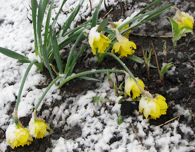
A few photos I took above of the snowstorm this week. Below is a picture from Vermont where over 50cm fell in the mountains.

Only in Canada could you go from 20C weather on Monday, a snowstorm on Tuesday, 20C weather by Friday and thunderstorms and 24C by Sunday. What a weather week. Power was slowly being restored across Vermont, NY and southern Quebec after the record setting snowstorm that saw nearly 2 feet of snow fall across some regions. Montreal had 7cm which melted by the end of the day on Wednesday. Another strong low pressure area is moving across Montana and the northern plains and into Ontario. A warm front will generate some showers this evening in the region followed by a partly sunny and warm Saturday and Sunday. The trialling cold front will sweep the Montreal area late Sunday with showers and thunderstorms. Severe weather is expected again this weekend in the plains and southern states. Meanwhile this storm delivered a powerful snow event to Alberta with heavy snow and winds gusting to over 100km/h in the southern half of the province. As much as 70cm fell in the foothills with about 10cm in Calgary. Numerous roads were closed and flights delayed.


Awesome win by the Habs, I through in this Aislin cartoon from Thursday's Montreal Gazette into the mix. They begin the next round against Pittsburgh tonight after defeating Washington in 7 games.

Wednesday, April 28, 2010

Storm totals

The intense low pressure area that moved from Boston into Maine yesterday, produced a major storm across the entire region. Snowfall amounts of 7cm were recorded at Dorval, a record for the date. The total precipitation was 36mm at the airport and 38mm at my place, that is nearly 1.5 inches of water equivalent. The snow depth varied on the island with over 10cm in the central part of the city near the mountain with lesser amounts off island on Ile Perrot. South of the city was a different story. Snow accumulated 10 to as much as 30cm near Granby and St Jean. The snow produced 2 fatal accidents on area roads as well as downed trees and power lines. Power is out this morning to nearly 35,000 Hydro Quebec customers with nearly the same amount out south of the border in Vermont and New York. Warnings remain in effect from the Townships into Vermont and New York with storm totals of 20 to 40cm expected.

For the record, the latest storm in Montreal was 21.8cm on May 10, 1963 with the latest measurable snow May 17, 1959 when 1.8cm was observed.

Skies should clear later today with the mercury reaching 11C and melting the snow here in the city. It may take a day or so elsewhere. Drive with care today especially south and east of the city.

Tuesday, April 27, 2010

Late season snowstorm

Hockey weather in late April in Montreal today with a record breaking 10cm snowfall.
I hate to use the term surprise when it comes to weather, but really this one caught me off guard. In a winter that has measured little in the way of snowfall, we managed to accumulate, in Montreal, on April 27, more today than the last two months combined. Over 10cm has fallen in many regions around the city. It varies greatly with elevation and surface. For most of the day the steady snow and gusty winds managed to keep visibilities under 1km across the southern half of the province. The low pressure responsible for this storm is near Cape Cod with and upper level feature spinning across the Champlain Valley. Temperatures have been just cold enough for the snow. By the time the precipitation tapers off most areas will have recorded 10-20cm of wet snow with over 30cm expected across the Townships, Green Mountains and Adirondacks with Jay Peak expecting nearly 2 feet. There is concern that the gusty winds and heavy wet snow may take down some power lines and trees limbs across the upper elevations. So far here in Montreal, it is the early spring flowers that have taken the hit. Warnings remain in effect for southern Quebec south and east of Montreal and for upstate New York and northern Vermont.

SNOW

Despite our warm spring snow is falling this morning in Montreal.

Heavy snowfall warnings are in effect this morning for the regions just east and south of Montreal including the Richelieu Valley, Townships, Beauce and Quebec City area. Wet snow has been falling across the area this morning and even in Montreal. Accumulations could be in the order of 10-20cm at elevations above 500 feet and just a slushy coating here in the city and on the valley floor. Winds have been gusting out of the northeast at 30 to 50km/h with a gust to 58km/h at Dorval overnight. Low pressure off the eastern seaboard will slowly move northeast today with cold winds and wrap around moisture producing wet snow right into the overnight period. Yesterday Montreal reached a high of 17C but we have dropped all the way down to just above freezing at 1C this morning. Light snow is also falling across Eastern Ontario including Ottawa. Precipitation should taper off this afternoon in Ontario.

South of Montreal Winter Weather Advisories are posted for the Champlain Valley in Vermont and NY, and St. Lawrence Valley of New York for 5-15cm of snow. Winter storm warnings are in effect for the Adirondacks and Green Mountains for up to 25cm. Places affected by poor travel today will include Plattsburgh, Malone, the Tri-Lakes, Stowe, Jay Peak, Newport and north towards Sherbrooke and Quebec City and the south shore of Montreal. Travel will be slippery with reduced visibilities on area highways, especially tonight. The combination of wind and wet snow may bring down power lines or tree limbs especially south and east of Montreal.

Monday, April 26, 2010

Snow in late April

Despite the fact it was 17C today and sunny, the entire region is expecting some wet snow over the next 24-36 hours. Winter Storm Warnings are in effect for the Eastern Townships, the Beauce and Quebec City regions for 5 to 20cm of wet snow beginning overnight. An upper level low will slide across the St. Lawrence Valley with moisture and very cold temperatures funneling into the region on strong northeast winds. The heaviest snow will fall at levels above 1000 feet, but indications are that we may even see a slushy accumulation at lower elevations including Montreal where it will be a blustery 4C tomorrow. The snow is also expected in the Adirondacks of NY and northern Green Mountains of Vermont with nearly 30cm expected by Wednesday morning with Winter Storm Watches currently in place. Winds will be gusty out of the northeast from 40-70km/h in the St. Lawrence Valley. A cold rain will mix with snow for most of the event at lower elevations. The system will move to our east by late Wednesday. If travelling east along Highway 10 or 20 or south into Vermont on Interstate 89 and especially 91, expect low visibility and slippery roads at higher elevations. More information on this developing storm will be posted late tonight.

Mississippi hit hard

Vehicles were swept off Interstate 55 in Mississippi from a tornado that cut a swath 1/2 mile wide and nearly 100 miles long across the state on Saturday. Below is a radar close up from Accu-Weather of the storm crossing I-55 in Mississippi.

Nearly 17 counties in the state of Mississippi have been declared disaster areas after a series of severe storms and tornadoes swept that state over the weekend. The storms were part of a strong spring low pressure area that spread rain and severe weather from the plains, Colorado and Texas across the lower Midwest and into the southeast, Mississippi and Alabama. The death toll is at 12 from the weekend including 10 in Mississippi. Hard hit Yazoo City, Miss, was flattened by an estimated F-4 tornado with winds in excess of 160mph. Over 600 buildings were destroyed including churches and brick buildings. Trees wee uprooted and flag poles bent over at 45 degree angles from the fierce winds. Cars and trucks were swept off Interstate 55 south of Vicksburg. The storms are affecting south Florida today from the Everglades east towards Miami.


SPRING SNOW
The same system is bringing showers to much of the middle Atlantic and Northeast. The low pressure is currently over Ohio and will move off the coast tonight while an associated upper level low spins into the Champlain Valley. The combination of these two systems will produce a cold northeast wind across the region tonight. As temperatures lower rain will develop and slowly mix with and change to wet snow over the higher elevations of the Townships and Vermont/New York. A winter storm watch has been posted for these regions with 10-30cm of heavy wet snow possible above 1000 feet. The NWS is estimating the heaviest snow to fall Tuesday night around Jay Peak, Vermont. Here in Montreal and the St. Lawrence Valley, a cold northeast wind will gust over 50km/h with showers changing to scattered wet flurries. No accumulation is expected in the Valleys. Snow fell over the weekend from Calgary east into southern Saskatchewan and North Dakota. This morning a snow/freezing rain mix is occurring in southeast Saskatchewan with warnings in place.

Friday, April 23, 2010

Weekend Update

From severestudios.com, a tornado near Goodnight, Texas yesterday.

A potent spring storm continues to sweep across the plains into the southern states today. This system was responsible for nearly 3 dozen tornadoes yesterday, primarily in Kansas, Colorado and Texas. The storms were impressive with heavy rain, hail and strong winds. While damage was reported, no serious injuries or fatalities were. The photo above is from a tornado near Goodnight in the Texas panhandle and was pulled from a dramatic video by storm chasers from SevereStudios.com. The entire video can be viewed HERE.

This system was expected to give us some rain by Sunday, but it now appears that high pressure will dominate the region with most of the activity passing well south of us into New York and Vermont. Overnight temperatures fell to the freezing point this morning with scattered frost. I had to scrape the car window on Ile Perrot to the southwest of Montreal this morning. As mentioned high pressure will give us clear cool nights and sunny warm days right into early next week. Some clouds and perhaps a stray shower may work into the border region with New York late Sunday.

The plains storm will continue to produce severe weather from Oklahoma and Texas east into Mississippi and Alabama today. More tornadoes are possible for the next 24-36 hours with this low and cold front. On the back side of the storm heavy snow, from 1 to 2 feet is forecast for the Colorado Rockies.

Thursday, April 22, 2010

Happy Earth Day

NOAA Visible Satellite of our little corner of the planet at sunrise on this Earth Day.

Clouds are slowly decreasing this morning as the overnight shower activity moves southeast of Montreal. Daytime heating may result in an isolated shower later today, but it should be dry in most areas. Skies will clear out tonight and it will be chilly, close to the freezing mark in many regions away from the cities and water. Some frost may occur. Friday and Saturday will be sunny and dry with pleasant temperatures, before low pressure from the US Midwest pushes showers and cooler weather into the St. Lawrence Valley for Sunday into early next week.
EARTH DAY
Celebrate Earth Day today by doing some simple things to help the planet. Don't idle the car at the drive through, get out and go inside for your coffee. Shut the water off while you shave or brush your teeth, take shorter showers. Turn lights off when you leave a room and power down the computer at night. All simple things that if done on large numbers, will preserve our wonderful country and planet for future generations. Try it today and make it a habit.
Click here for more information: Earth Day!

Wednesday, April 21, 2010

More showers today

Despite Environment Canada's forecast for dry weather today, I believe the day will evolve the same way the previous two have. I expect the sunshine and warm temperatures for most of the day to generate showers and isolated thunderstorms across the region by late afternoon. These storms will be enhanced by a weak cold front later this evening with the risk of gusty winds in several of the storms, especially near the US border and into northern New York. Thursday will be cloudy with showers most of the day before clearing skies for a beautiful Friday and Saturday.
I am hoping to take my new lawnmower out for a test drive Saturday. It looks like an ideal day for any outdoor chores or activities. Temperatures will be slightly cooler but still above normal for April. Sunday looks showery at this time.

Record Highs
It's Alberta's turn for record high temperatures this week. Strong high pressure is pushing daytime highs into the mid-twenties as far north as the Yukon & NWT. At least a dozen record high temperatures were set yesterday including 26C at Grand Prairie and 24C at Edmonton. In the NWT, it was 20C in Yellowknife, 25C in Hay River and 12C for a record high all the way north in Inuvik.

Tuesday, April 20, 2010

A few thunderstorms

Despite the presence of high pressure across the region, a weak frontal trough set off some sprinkles and showers late Monday afternoon in Montreal. It was just enough to wet the rain gauge, far less than the 40mm or so that drenched the region Friday into Sunday. there was even snow reported in some areas south and east of the city with as much at 10cm falling in northern Vermont and southern Quebec near the Vermont border.

Skies are sunny this morning across eastern Ontario and Quebec with mild temperatures. It will be dry most of the day, but a weak cold front will combine with a slightly unstable air mass and daytime heating to generate more showers and isolated thunderstorms by late in the day. Skies will clear out this evening before the same scenario occurs on Wednesday with more showers and thunderstorms. Conditions should improve on Thursday.

Volcano Update:
Regarding the volcanic eruption on Iceland, some flights are beginning to take off in southern Europe, but it may be another day or so before Britain and northern Europe can begin scheduling flights. New eruptions today are threatening to expand the ash cloud once again. So far the predominately westerly winds have kept the ash from affecting eastern Canada. The cost of this eruption is being estimated in the hundreds of millions of dollars a day with over 10,000 flights being canceled worldwide, including the transportation of perishable goods.

Monday, April 19, 2010

Volcanic ash moving west

Ash rising from this Iceland volcano continues to ground air travel in Europe causing a ripple effect around the globe. The economic impact will be significant. BBC Photo

The erupting volcano under the Eyjafjallajoekull Glacier in Iceland continues to send ash thousands of kilometres across the Atlantic into northern Europe. The ash has grounded air travel since last Wednesday forcing cancellation of over 4000 flights and stranding thousands of passengers. There are indications that the ash is now moving westward towards Canadian air space and Newfoundland. Low pressure in the north Atlantic is creating a northeast wind in Newfoundland carrying the ash towards that province. The exact impact is not clear at this time, however Environment Canada is closely monitoring the situation. Several flights to St. John's have already been cancelled. A special statement has been issued by Environment Canada HERE.

Friday, April 16, 2010

Weekend Weather

A warm front is lifting slowly north this morning across the St. Lawrence and Champlain Valley's. Montreal is at 5C with rain while Toronto is sunny and 16C. The precipitation has been steady all night with even a little light snow being reported in northern Vermont and New Hampshire and across the eastern Townships. The rain will taper off to showers this morning before the cold front associated with this system approaches the region later today. Showers and isolated thunderstorms are possible along the front especially in Ontario and upstate New York. An upper level low will drop across the region over the weekend with a prolonged period of showers and cool weather. This is a major change in the forecast from earlier in the week. Originally I believed the low would pull off to the east by today, but it has slowed considerably.

**This is an awesome video of a meteor shooting across the Midwestern sky last night. Check it out here at ACCUWEATHER.COM

Tuesday, April 13, 2010

Prairie spring storm

While sunny and seasonable weather is expected here in Ontario and Quebec, a big wet and windy storm over the central Rockies is forecast to move north into western Saskatchewan tonight and Wednesday. The track of the storm will split the province in two with mild air, strong south winds and even thunderstorms from Regina and Gravelbourg east and heavy snow and blizzard conditions in the southwest part of the province and along the Alberta border into the extreme eastern portion of that province. Heavy snow will develop tonight especially in the Cypress Hills and Shaunavon region. Look for 20-30cm of wet snow with increasing northerly winds to 70km/h. Rain and thunderstorms this morning will change to heavy wet snow on increasing north winds this afternoon in the southwest portion of Saskatchewan. Blizzard conditions are forecast along the Trans Canada Highway from east of Red Deer to west of Swift Current. Travel will likely become impossible overnight. East of that area heavy rain, up to 25mm will drench the southern grain belt into northern Montana and the Dakotas. All regions will see strong winds of 50 to 100km/h from this storm.

Monday, April 12, 2010

Sunny week

Just a quick update on this Monday morning. High pressure will provide most of Ontario and Quebec with a sunny and seasonable week with temperatures warming to above normal by Wednesday. Overnight temperatures will be near normal but chilly at 1C. The next threat for precipitation will come Friday as low pressure brings a cool rainy day before clearing skies for another sunny weekend.

Friday, April 09, 2010

Weekend Update

Showers are slowly coming to an end this morning in the Montreal region as low pressure and a trailing cold front move east of the city. Skies will break by mid-morning, but it will be windy and chilly with temperatures struggling to reach 10C. Tonight will be windy and cold with overnight temperatures near the freezing mark and even a few flurries in the air. Saturday will be windy once again with scattered showers, but some breaks in the cloud as well. Skies will finally clear Sunday with slightly milder air and a high near 14C.

Low pressure moving across western Saskatchewan is producing an area of steady snow today with 10-20cm forecast. The big story with this system is a trailing cold front that has a history of wind damage from southern BC across Alberta. Winds will howl out of the west in Saskatchewan at speeds of up to 100km/h. Wind warnings are in place across most of the southern and central parts of the province and into northern Montana. Blowing snow in the north and west and blowing dust in the south will make travel difficult at times with near blizzard conditions possible along the Yellowhead from the Battlefords to Lloydminster.

Yesterday 14cm of snow fell at Kirkland Lake in northern Ontario with 10cm in the Soo east to Sudbury.

Thursday, April 08, 2010

Thunderstorms & SNOW

Heavy snow over Washington and Montana is now moving into Alberta and Saskatchewan. KOMOnews.com photo

The title of my blog entry this morning was fairly accurate as winter and spring wage a battle across many portions of Canada. Tonight heavy thunderstorms are moving across eastern Ontario into western Quebec. Thunderstorm Warnings have been posted for Lachute and St. Jerome. By 9pm these storms will be near metro Montreal. Heavy rain, 90km/h winds and reports of marble size hail have been observed with these storms in Prescott/Russell and Glengarry Counties in Ontario. Rain will continue overnight and into early Friday.

Meanwhile a strong cold front is moving across Alberta associated with low pressure near Red Dear. Winds are gusting to 100km/h across the southern Rockies and into Saskatchewan. Steady rain has turned to snow in many parts of Alberta and the snow will spread into Saskatchewan. Calgary is reporting near zero visibility in snow with winds of 95km/h. Portions of the central grain belt could see 15cm of snow. Heavy wet snow is also falling in northern Ontario and in northern Michigan. Over 10cm of wet snow fell today in Sudbury where it was over 27C just days ago.

Dueling Seasons

Despite the heavy snow this winter, record heat is producing a serious fire threat across portions of the northeast including New Jersey - shown above yesterday, where temperatures were in the upper 80's.

There is lots to talk about this morning, and I will try to maintain some order, rather than my usual routine of being all over the place. Lets start with yesterday and that line of thunderstorms that raced through Montreal around 8:45am. They dumped about 15mm of rain in just 15 minutes across portions of the island and south onto the south shore. It also produced reports of 1cm hail. Temperatures yesterday remained chilly all day in Montreal and along the US border as we remained in the cool sector. Just south of us more record heat was sending temperatures soaring into the 90's. Boston had a high of 91F, the earliest 90 degree day ever. They usually do not surpass 90 until June 5 on average. A cross section of the temperatures across the region from north to south at 3pm yesterday looked like this, Montreal 13C, Burlington 15C, Montpelier 25C, Springfield, VT 29C, Boston 32C and New York City 32C. I think you can see where the warm front was lying.

Today is very different in the region. A cold northeast wind has dropped temperatures down to 3C here in Montreal with drizzle. We can expect it to remain chilly for the next 36 hours with steady rain at times and the risk of thunderstorms as well. Winds will be gusty from the northeast at 30-50km/h. The air has chilled sufficiently enough in the western Ottawa Valley for freezing rain this morning. On the back side if our rainmaker, low pressure moving across the Ohio Valley, snow is falling in Wisconsin, northern Michigan and northwest Ontario. From 10-15cm of wet snow is forecast. Showers and thunderstorms will continue across our region into Friday before it slowly clears out with a risk of some flurries. The weekend looks sunny and seasonable.

Wednesday, April 07, 2010

First thunderstorm

9:38 Watch expired - storms are off to the east of the city.

9am:
A severe thunderstorm watch as been posted for Montreal until 10:30am. More thunderstorms are developing in the moist unstable air mass and producing very heavy rain, lightning and small hail. One passing over the West Island at this hour is dumping torrential rain with low visibility and very dark skies. These showers will move across the island over the next hour.

The first thunderstorm of this young 2010 season rattled across Ile Perrot and the western tip of Montreal island at around 3am this morning. Thunderstorms developed along a warm front that is stuck here in the St. Lawrence Valley. It will slowly begin to sag back south again into upstate New York leaving us on the cool and unstable side of it. A northeast breeze will hold temperatures around 12C today in Montreal while they will reach 20C in Toronto and Burlington and 30C in New York City. Low clouds and fog along with drizzle will also occur here in Montreal. In the last hour more thunderstorms have fired up in the Ottawa Valley and are rapidly moving east so we may have another rumble or two of thunder. The storm overnight dropped about 15mm of rain into my gauge at home.

Moving forward we can expect low pressure from the Midwest to move into our region Thursday with another 10-20mm of rain followed by much cooler weather and the risk of a flurrie or two Friday and early Saturday. Skies will then clear out for a sunny and seasonable weekend.

This morning temperatures are already approaching the mid 70's (22 to 24C) across the Ohio Valley and mid Atlantic, while in Denver and across Colorado, Wyoming and the Dakotas, light snow is falling with temperatures below freezing.

Tuesday, April 06, 2010

Battle of the seasons

Lake Champlain looked inviting in the 80 degree weather this past Saturday.
However the National Weather
Service is warning people to stay away from area rivers and lakes that are running high and fast, and most importantly are only about 36F (2C) at this time of year. Hypothermia can occur in seconds.
The same rule applies on both sides of the border.
ValleyWX Pic


That may have been one of the best long weekends ever. Bright sunshine and record high temperatures in the upper 70's (20's C) on Friday and Saturday, were followed by decent weather with very mild temperatures for Sunday and Monday. While no records were broke yesterday the temperatures remained well above normal. Record warmth is being felt all along the eastern seaboard with temperatures in the 70's and 80's or about 20 to 30 degrees above normal. The normal high in Montreal is about 43F (8C) for April 6. Despite clouds and showers from and advancing warm front today, we will still reach the 55 to 60F (13 to 15C) range. Rain will develop along that front today in the St. Lawrence Valley, and taper off after midnight tonight. Warmer temperatures with some breaks are possible on Wednesday in the warm sector. A sharp gradient will be in place from north to south with temperatures in the upper 70's in southern New England to near 60 (16C) in Montreal tomorrow. A cooler pattern with more rain and even some flurries is possible by Friday.

Meanwhile out west, winter continues with heavy snow falling across the Rockies and northern plains. In between, heavy thunderstorms are forecast in the Midwest, Ohio Valley, and eventually the Great Lakes and northeast by late tomorrow. We may even hear a rumble of thunder in Montreal for the first time this season.

Friday, April 02, 2010

Summer warmth

5pm UPDATE: New record highs today: 25C Montreal, 28C Ottawa and Prescott/Ogdensburg. Lake Ontario is keeping Kingston cool at 17C while just up the 401 Brockville is 27C.
Meanwhile the cool Atlantic is keeping Boston at 11C (52F) while most other locations in New England are in the 75-80F range with the exception of the immediate Lake Champlain shore line and as mentioned the immediate New England coast.

It appears we will skip a season, at least for the next two days. Strong high pressure will dominate the weather along the Atlantic coast and New England into southern Quebec and Ontario. The warm sunshine and strong southerly flow will push the mercury to summer readings of about 20 degrees above normal to record highs of 25C in Montreal and 23 to 27C in most regions away from the rivers or lakes. The cooler bodies of water will keep temperatures down in places like Kingston. The record high in Montreal for today was 16C set in 2009 and for tomorrow's date it is 21C set in 1981. If all goes as planned we should shatter those records. Temperatures are responding slowly this morning as areas of fog burn off. But they are coming up nicely to our west and south with readings already near the 17C mark along the US/Ontario borders.