Friday, August 26, 2022

Perfect late summer weekend weather for southern Quebec

The weather this August has been rather unsettled, with plenty of clouds at times and highly variable weather. Trudeau Airport has recorded 80.7mm of rain for the month, with 66.2mm at my home on Ile Perrot. More showers and thunderstorms are possible Friday, before a near-perfect late summer weekend.

Summer is slowly fading away. Meteorological fall arrives September 1st, but the actual weather usually remains warm well into September across southern Quebec. We are looking at a very pleasant weekend to end what has been another "ok" summer month in Montreal. This summer has been just like that, ok, with nothing spectacular on either end of the weather spectrum.

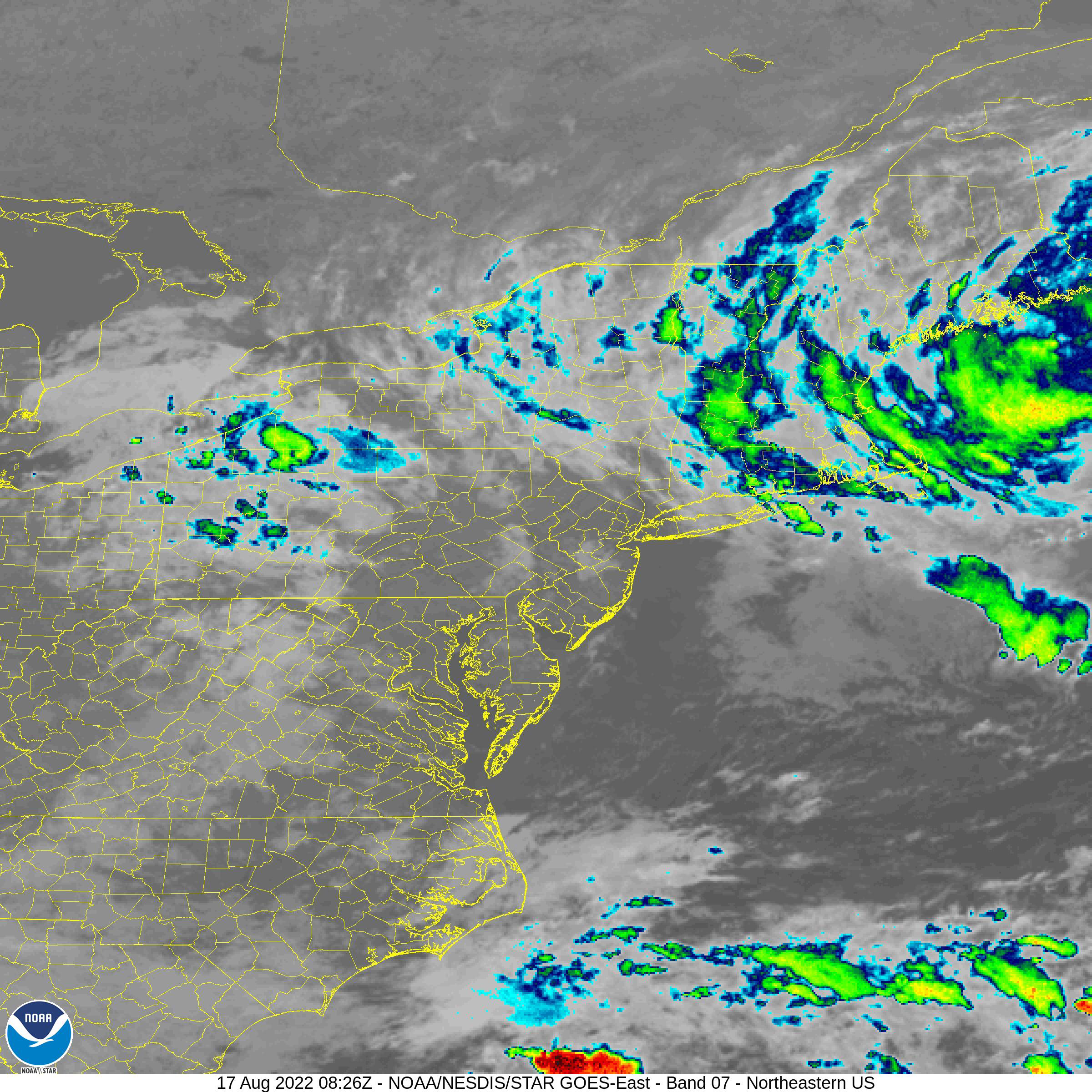
For Friday, we have a warm front lifting across southern Quebec this morning, accompanied by showers and perhaps a rumble of thunder. That will be followed quickly by a cold front and weak low pressure area by early afternoon. The result will be general cloud cover along with 10 to 25mm of rainfall across the region. The threat for severe weather is low in Quebec, with most of the stronger storms occurring this afternoon across central New York State and southern Vermont where temperatures will be higher. The high in Montreal Friday will be in the low 20s. 

Skies will clear this evening, setting the stage for a near-perfect late summer weekend. Expect some fog patches early Saturday morning, but otherwise clear skies. Sunshine on Saturday and Sunday will be accompanied by comfortable relative humidity levels. Expect a high near 23C (73F) Saturday and 27C (81F) Sunday.

By Monday high pressure will move to our southeast, with a return flow of very warm and humid air invading the region straight from the Gulf of Mexico and the southern US. Look for the last three days of August to be sultry, with highs near 30C (86F) and humidex values well into the 30s. There will be a possibility of strong thunderstorms in Montreal both Tuesday and Wednesday afternoon, but the timing of the threat will need to be fine-tuned.

Monday, August 22, 2022

Strong thunderstorms leave 80,000 without power across southern Quebec

Over 100 Hydro-Québec crews were on the job late Sunday and Monday after thunderstorms cut power to 80,000 southern Quebec homes. (Hydro-Québec Photo)

Strong thunderstorms developed Sunday afternoon across northern New York and eastern Ontario, before moving northeast across the metro Montreal region. Winds gusted up to 87km/h at Trudeau Airport, knocking down tree branches and in the process cutting power to many homes and businesses. The West Island of Montreal was specially hard-hit, with frequent lightning strikes adding to the outages. A second line of storms affected the city around 10:45pm.

In all over 80,000 Hydro-Québec customers were left without power in the province at he height of the storms. The utility has over 100 crews working on the outage, and as of 9am Monday morning, the number of affected clients was down to 22,891.

The thunderstorms came at the end of what was a sweltering hot and humid weekend. Temperatures were either side of 30C (86F), with humidex values approaching 38C (100F). Temperatures are slightly cooler Monday, with plenty of cloud cover, but the airmass remains humid and unstable, and more thunderstorms are expected today and Tuesday. High temperatures will reach 24-27C (76-80F)

Much needed rain fell with the thunderstorms, with 24.2mm at Trudeau Airport, and generally 15 to 40mm across southern Quebec. The monthly total for Montreal now sits at 70.3mm, with most of that falling over just two days.

Skies will clear Wednesday, and humidity levels should lower a touch, but temperatures will remain warm at 28C (83F). 

Wednesday, August 17, 2022

Unsettled weather to end the work week before heat and humidity return to Montreal

It was a perfect weather day end to end for the 40th Annual Firefighters' Day in Pincourt last Saturday. Numerous municipalities across the metro Montreal region took part including this spectacular truck from Kahnawake. (ValleyWeather Photo)

The weather has been a little unsettled this week, with an upper level low spinning across New England. This system has been pulling in moisture from an ocean storm located south of Maine. The result was isolated showers and even a few thunderstorms moving in the unusual direction of east to west across southern Quebec. The low will eventually move eastward relaxing its grip on our weather, but not before another 24 to 36 hours of scattered precipitation.

A NOAA satellite image from Wednesday afternoon showing showers pinwheeling westward over New England into southern Quebec from an ocean storm located along the Maine coast. (NOAA)

Conditions however will be dry most of the time, along with fairly moderate temperatures. Highs will be in the middle 20s, with overnight lows in the upper teens. Conditions will feel muggy at times, with the airmass being of maritime origin. Friday will be partly cloudy as well, with just an outside chance of a scattered shower or two.

High pressure will build back into southern Quebec for the upcoming weekend along with very warm late summer temperatures. It will be another spectacular August weekend, with mostly sunny skies forecast. Highs on both Saturday and Sunday will be near 30C (86F), with overnight lows near 20C (68F). The next chance for showers and thunderstorms will be Monday as a frontal boundary approaches southern Ontario and Quebec. The humidity will begin creeping up on Sunday afternoon, with warm and muggy weather expected Monday and Tuesday, and highs near 27C (81).

Tuesday, August 09, 2022

Much cooler air arrives in southern Quebec

Our heatwave came to an abrupt end on Monday, with fall-like temperatures observed. Above, a brief heavy rain shower moves through Montreal on Monday morning. While close to 25mm fell at Trudeau Airport, it was far less than many locations north of the city. Between 40 and 90mm fell across the Laurentians towards Quebec City, with Ottawa receiving 105.5mm since late Sunday afternoon.

We had a taste of September weather on Monday after three scorching hot days. The high on Monday in Montreal was only 18.6C (66F) behind a very slow moving cold front. That front was the focus for very heavy rainfall, that oddly enough seemed to skip metro Montreal once again. 

I measured 20.4mm on Ile Perrot, most of that falling overnight into Tuesday morning. Meanwhile, 24.6mm fell at Trudeau Airport since late Sunday, 31.5mm at St. Anicet, 60mm at Rawdon, 90mm at Trois-Rivieres, and an incredible 105.5mm, over 4 inches of rainfall, at Macdonald-Cartier Airport in Ottawa. 

There was very little thunderstorm activity in and around Montreal, allowing for less rainfall. Temperatures and humidity levels were very high over the weekend, with a high of 32.2C (90F) on Saturday, and 32.5C (90.5F) on Sunday. The dewpoint temperature reached a sweltering 23.8C Sunday afternoon, producing a record setting humidex of 43C (109F) in Montreal. All that went away quickly on Monday as much cooler air arrived on chilly northeast winds. 

The slow moving nature of the cold front meant you did not have to go far away from Montreal to find the heat on Monday. Places like Burlington, Vermont, Plattsburgh, NY and Brockville, Ontario still were in the high 20s to near 30C with high humidity.

We have lingering showers and drizzle early Tuesday morning, along with chilly temperatures. Skies should gradually clear in the afternoon, with high temperatures rising into the low 20s. Most of the balance of the week into the weekend looks fair and seasonable, with highs in the middle 20s and lows in the middle teens. The only exception will be the arrival of a cold front Thursday, accompanied by scattered showers and perhaps a rumble of thunder. It will become less humid behind that front, with a refreshing weekend in store, ideal for any outdoor activities.

Thursday, August 04, 2022

Hot and humid weekend ahead for southern Quebec

The St. Lawrence River along the Verdun shoreline taken Monday, July 25. Skies cleared behind a cold front early in the day leaving some fair weather clouds along with strong west winds, gusting up to 73km/h. This was part of what turned out to be a fairly average July in the Montreal. (ValleyWeather Photo)

A soupy airmass has arrived in Montreal as a warm front lifted across the St. Lawrence Valley Thursday morning. Hot and humid air is streaming north into the region. Clouds and scattered showers will likely hold temperatures down in Montreal Thursday, perhaps reaching 28C (83F). Regions south and east of the city are forecasting highs well into the 30s. Factoring in the humidity,  the weather will feel closer to 40C (104F) outdoors. Overnight lows temperatures will remain very warm and sticky through Sunday, between 21C and 23C (70 to 73F).

More showers and isolated thunderstorms are possible through Thursday night and Friday, as a weak front moves across the region. That front will wash out late Friday, allowing the heat and humidity to build back in. Highs Friday will once again be held into the upper 20s, but will rise into the low 30s with elevated humidity both Saturday and Sunday. The weather will be oppressive this weekend,  keep this in mind if you have outdoor activities planned. Drink plenty of fluids and watch for heat stroke.

Late Sunday a more potent cold front will arrive with plenty of showers and isolated thunderstorms. With the moisture latent airmass in place, there is the risk for some very heavy rainfall late Sunday and Monday in the St. Lawrence Valley. Much cooler weather will arrive to start next week, with temperatures falling back into the middle 20s. 

July Summary

July was just ok in Montreal, nothing spectacular. Temperatures were close to normal, with an average high of 27.1C (80.8F) in Montreal. The long-term average is 26.3C (79.3F). Montreal recorded only four 30C days in July, but 6 additional days fell just shy of that, between 29C and 29.9C.

We managed 73.6mm of rain in July, most of that falling during a few hours on the evening of the 18th.  The normal for the month in Montreal is 89.3mm. Most thunderstorms managed to skip around Montreal, preferring a path through the Laurentians. For that reason, the first four tornadoes of the 2022 season in Quebec, occurred over that region. On July 1st an EF-1 tornado occurred at Val-de-Lacs. Winds were estimated at 145km/h. Damage and power outages were reported. A strong line of thunderstorms produced three more tornadoes on July 23 near Saint-Adolphe-d'Howard. The strongest, and EF-2, with winds estimated at 200km/h, caused extensive damage to several homes and knocked out power to thousands. Two other satellite tornadoes, an EF-0 with 110km/h winds and an EF-1 with 140km/h winds spun off from the main storm, uprooting trees and snapping power poles. Thankfully no injuries were reported in any of the storms.

Briefly looking ahead to August, it appears southern Quebec will be warm and humid, with slightly above-normal temperatures. A fierce heatwave that has scorched the southern and central plains will begin to expand north and east allowing some of the warmth to arrive in southern Ontario and Quebec.