Monday, February 27, 2017

Wild weekend weather

Sunday morning revealed heavy damage to a church in Franklin County, Massachusetts, after the first-ever February tornado to hit the state touched down late Saturday. (Photo via Twitter @cbsboston)
After a crazy weekend of bizarre weather, Monday has dawned relatively calm and mild in Montreal. The weekend featured strong thunderstorms, record-high temperatures, snow and whiplash-like temperature swings. On Friday night, rare February thunderstorms developed along a warm front in eastern Ontario, affecting the Ottawa Valley, and points north of Montreal. Saturday was a windy, warm day for most locations in southern Quebec. The warm air, however, had a very difficult time making it into metro Montreal, resulting in some incredible temperature contrasts. At one point Saturday afternoon, Montreal was 1C (33F), while Granby, 80km to our southeast, was 16C (61F) and Burlington, Vermont was 23C (73F). The 23C reading in Burlington was an all-time record high for the month of February, besting the record establish just last Thursday. By 3pm, the warmth briefly surged into Montreal, with the mercury soaring to 14.5C (57F), the warmest February day since 1981. That high also established a new daily record for Montreal, surpassing the previous of 8.9C set in 1956.

Rare February tornado
The warm air lasted less than one hour in Montreal, as a strong cold front came barreling through the region. The front featured thunder, lightning, hail, wind gusts over 70km/h at Trudeau, and very heavy rain. In just a few hours, Montreal recorded 26mm of rain, with 42mm at the McTavish weather station in downtown Montreal. The temperature fell rapidly, below freezing by midnight, with snow flurries. That same cold front produce widespread severe weather from southern Ontario into the middle Atlantic US. This included the first-ever February tornado on record in Massachusetts. The tornado, and EF-1 with 100mph winds, touched down Saturday afternoon in Franklin County. The storm caused damage and one injury.

The upcoming week will feature more mild temperatures and snow melt. Another low-pressure area will produce rain on Wednesday, with an additional 15-25mm possible. Environment Canada has posted a special weather statement for the possibility of flooding in some regions of southern Quebec. Flooding is also likely in upstate New York and northern Vermont.

Friday, February 24, 2017

An early taste of Spring for Montreal

After flirting with record high temperatures on Saturday, windy and colder weather will return Sunday, along with snow showers. (AccuWeather.com)
Record warmth followed by rapidly dropping temperatures
Thursday was one for the record books across many parts of southern Quebec and eastern Ontario as warm air surged northward. A break in the clouds pushed temperatures well into the lower to middle teens. Numerous new record high temperatures were established, including 17C (63F) in St Anicet, Quebec, Massena, NY and Cornwall, Ontario. In Toronto, the mercury hit 17.7C (64F), setting a new record high for the entire month of February. I recorded 15.6C (60F) here on L'Ile Perrot. As usual, Trudeau Airport was slightly cooler than most surrounding areas, recording 12.3C (54F), falling short of the record of 12.9C set in 1981. Burlington, Vermont posted a high of 17C (63F), also an all time high temperature for February. The snow pack has been cut by nearly two thirds since our big storm last week. The warm temperatures will increase the risk of flooding along some rivers in the region. Venturing anywhere near frozen rivers is not advisable, as the ice has become extremely unstable.

Windy and colder by Sunday
Strong low pressure over the upper Midwest is forecast to move across Lake Huron and into western Quebec this weekend. This storm is generating blizzard conditions west of the track, with severe thunderstorms to the south and east. A warm front will lift north into southern Quebec late today. Expect some rain or even spotty freezing rain along the front late today and into the overnight period. There is even the risk of some thunderstorms. Freezing rain warnings have been issued for the Ottawa Valley as well as Quebec City and regions north of Montreal. Temperatures will be much colder today, before another surge of very warm air Saturday. The high today in Montreal is expected to be 4C (39F). The temperature will then rise overnight into Saturday reaching above 10C (50F). A rather strong cold front will approach southern Quebec late in the day Saturday. Winds will become strong, 30-60km/h, along with showers and thunderstorms. Behind the front, cold air will surge into Montreal, with rapidly dropping temperatures and flurries forecast overnight into Sunday. Some locations will drop by 10 to 15 degrees in a matter of hours.Temperatures in Montreal will fall from near record highs Saturday to well below freezing, -5C (23F) by Sunday morning. Anyone travelling Saturday night should expect rapidly changing weather conditions with icy roads developing.

Monday, February 20, 2017

The big melt is on across southern Quebec

Soaring temperatures caused a rapid snow melt this past weekend. The image above shows tons of snow being removed from the side of the Centre Multisport in Vaudreuil. Residents were also chopping ice, freeing rain gutters and clearing driveways after 50cm of snow fell last week.
After nearly 50cm of snow in less than a week, southern Quebec was treated to an early taste of spring. Over the weekend, temperatures soared  above freezing into the upper single digits and teens. On Saturday, Windsor, Ontario established a new record-high temperature, reaching 19C (66F). On Sunday, another record was set at 17.9C (65F). In eastern Ontario, Cornwall recorded a high of 11C (52F) on Saturday, while Montreal reached 7.6C (47F) on Saturday and 8C (48F) on Sunday. The Sunday high was just shy of the record established during the very warm month of February 1981. Abundant sunshine accompanied the warmth, melting away almost half of the snow that fell last week. More melting can be expected this week, as mild temperatures are forecast to prevail.

High pressure will give Montreal a chilly night Monday, before warm southwest winds develop on Tuesday. A weak warm front will produce a few showers on Tuesday evening. Wednesday will be very mild again, with temperatures approaching 10C (50F) across the region. The warmth will remain into Thursday. The normal high in Montreal for late February should be -3C (27F), with overnight lows of -12C (10F).

Too early to celebrate spring
Despite the early taste of spring,  much colder air is forecast to move into Montreal by next weekend, with rain changing to snow on Saturday. The precipitation will be generated by a rather vigorous low-pressure area moving across the central Great Lakes. Rain will develop early Saturday and change to wet snow before ending Sunday. A strong cold front will produce a rapid drop in temperature Saturday night. This system will need to be monitored closely. The potential exists for a flash freeze and significant snowfall for some regions of southern Quebec late Saturday.

Wednesday, February 15, 2017

More snow followed by a much warmer weekend in Montreal

Heavy snow begins to fall during the morning commute in Montreal on Wednesday morning. (ValleyWX)
A rather strong snow squall moved across southern Quebec this morning, impacting the commute in Montreal. The squall put down a quick 5 to 10cm of snow across the region. Near whiteout conditions prevailed, right in the middle of the morning rush. The snow has eased for the moment, but more squalls are possible later this morning and into the afternoon. There is plenty of instability in the atmosphere, even a rumble of thunder is possible during the most intense squalls. Tonight, low pressure will deepen rapidly off the New England coast, pumping abundant moisture back into southern Quebec. A heavy snowfall warning has been posted for the region south of Montreal to the US border and the Townships. This includes Vaudreuil/Dorion and Valleyfield. Steady snow will develop this evening, and taper off Thursday morning. Total storm accumulations for the 24 hours will be in the 15 to 25cm range across southern Quebec by morning. Less snow is forecast to the north of Montreal, with more to the south of the city.

The high temperature will be either side of 0C (32F) through the storm. Overnight low temperatures will be between -6C (21F) and -10C (14F) in Montreal. On Friday, high pressure will begin to nudge into southern Quebec with clearing skies and milder temperatures forecast. By the weekend, we will see the mercury go above freezing, up to 2C (36F) Saturday, and 6C (43F) Sunday.

Monday, February 13, 2017

Break between storms for Montreal after 30cm of snow

The storm begins on L'Ile Perrot Sunday afternoon. Between 25 and 30cm of snow has fallen on Montreal since noon Sunday. (ValleyWX Photo)
The largest winter storm of the season is all but over this morning after dumping 29cm of snow on Montreal, with more to the south and west of the city. Roads are snow-covered but passable this morning. Winds will be gusty, up to 40km/h at times, but the snow should end shortly. Here on L'Ile Perrot, I measured close to 30cm (1 foot) on my driveway this morning. On Sunday, the snow fell fast and furious, with hundreds of accidents reported across southern Quebec and into Ontario. Ottawa set a record for the day, with 28cm of snow between 10am and midnight. Toronto had 15cm, the largest storm of the winter for them. The snow delayed or cancelled hundreds of flights from Montreal to Toronto, New York and Boston. Call ahead this morning and expect delays.

The system responsible for the snow is now in the Gulf of Maine, moving rapidly towards Nova Scotia. As a result, the winds will not be as strong today as originally forecast. Blowing snow will still be problematic, but mostly off the island of Montreal. The storm will be severe today in coastal Maine and Nova Scotia, and later into Newfoundland. Some locations will see in excess of 50cm of snow along with winds up to 100km/h.

The next snow maker is already on the horizon for Montreal. Low pressure will sweep across the Great Lakes Wednesday and try to merge with a coastal low. Currently I am not expecting a big storm for Montreal, but perhaps another 5 to 10cm on top of this mess. The possibility exists for more, but that scenario is becoming less likely. Temperatures will be near normal values through the end of the week, but rise above freezing by next weekend.

Saturday, February 11, 2017

Winter storm for Montreal

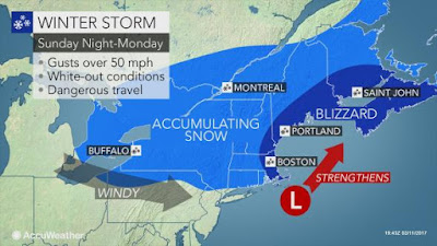
Low pressure is forecast to intensify rapidly off the Maine coast late Sunday, delivering Montreal the largest snowstorm of the winter so far. (AccuWeather.com)
An active weather pattern will bring several rounds of accumulating snow to southern Quebec over the next few days. Heavy snowfall warnings are in effect for eastern Ontario and southern Quebec, including metro Montreal, from Sunday into Monday. Low pressure is forecast to move from the lower Great Lakes across New England, while a second storm develops rapidly off the Maine coast. The two storms will merge, producing heavy snow, starting Sunday morning in Ontario and by early afternoon in Montreal. The snow will be heavy at times, with accumulations expected in the 15 to 30cm range (6 to 12 inches) by Monday. Winds will strengthen late Sunday, up to 40km/h, increasing on Monday to well over 60km/h. Expect widespread blowing and drifting snow in the St. Lawrence Valley.

Winter storm warnings are in effect for all of New England and New York for similar conditions. Air travel will likely become very difficult across the northeast US and eastern Canada by late Sunday. Any unnecessary road travel outside metro regions should be postponed Sunday. If the forecast conditions develop as expected, this will  be the most significant snowstorm of the season so far in Montreal. Temperatures will remain cold throughout the storm here in the St. Lawrence Valley. The high on Sunday in Montreal will be near -6C (21F), with the overnight low near -8C (18F).

We will get a brief break on Tuesday, before another storm arrives Wednesday with more snow for Montreal.

Friday, February 10, 2017

Snowy weekend for Montreal

The biggest winter storm of the season hit southern New York and New England on Thursday, causing widespread power outages and accidents. (Massachusetts State Police photo)
After a week of fluctuating temperatures, snow and ice, we will have a brief respite today. That break, however, will be a cold one, with temperatures at -16C (4F) this morning, and an excruciatingly cold northwest wind of 40km/h. Windchill readings are in the minus 20s. The sun will appear briefly today, but it will be cold, with daytime highs struggling to reach -12C (10F).

On Thursday, a strong winter storm passed well south of Montreal, dumping heavy snow across southern New England. Some regions reported as much as 40cm of snow, along with winds of 100km/h. Nearly 50,000 customers lost power, as the region's largest storm of the year moved into the Atlantic. Today the storm is racing off towards Newfoundland.

On Wednesday, icy roads were a factor for this school bus ending up in the ditch in La Presentation, Quebec, southeast of Montreal. There were 25 children on board. Thankfully no injuries were reported. Thick ice remains behind after a rapid freeze on Thursday. (Global News)
SNOWSTORM
Our attention will now turn towards a clipper-type low-pressure area expected to move from the Great Lakes into New York over the next 24 hours. Light snow will spread into Montreal overnight and taper off on Saturday. Accumulations will approach 5cm in our region. On Sunday, twin low pressure areas are forecast to develop and attempt to merge off the New England coast. The potential exists for snow to develop by later Sunday and continue into Monday. At this time, the forecast is for all snow, unlike previous systems. A good 10cm is possible in southern Quebec, but that amount may increase considerably depending on the strength and track of the developing storms. I will post more details this weekend. Temperatures will moderate with the cloud cover and snow, up to -8C (18F) Saturday, and -4C (25F) Sunday. The snow will continue into Monday in Montreal, promising a sloppy, slow commute.

Monday, February 06, 2017

Freezing rain warnings posted for Ontario and Quebec

Another icy mix of snow, freezing rain and rain is forecast for Ontario and Quebec, Tuesday into early Wednesday. (AccuWeather)
Freezing rain warnings have been posted by Environment Canada for all of eastern Ontario and southern Quebec including Montreal. Low pressure, with an elongated warm front, will approach the Great Lakes early Tuesday and move down the St. Lawrence Valley on Wednesday. As with every other storm this winter, this system will be accompanied by a surge of warm air. Snow is forecast to start Tuesday morning in southern Ontario and spread into Montreal by mid-afternoon. The snow will mix with sleet, and eventually change to freezing rain. Accumulations of snow will range from 3 to 5cm from Montreal south to the US border. Expect 10 to 15cm north and east of the city towards Quebec City. A prolonged period of freezing rain is likely Tuesday night in Ottawa and Montreal. Winds are forecast to increase in southern Quebec, up to 50km/h Tuesday and 70km/h by Wednesday. The combination of ice on trees and wires and strong winds may produce some isolated power outages.

The temperature will be warming up on Tuesday, from -10C (14F), up to 0C by midnight. The high on Wednesday will be early in the day, around 2C (36F). Expect rain showers changing to flurries, with very strong winds. Colder air returns behind the storm for Thursday, with a low of -16C (4F) and a high of -5C (23F).

Expect very poor travel Tuesday and Wednesday across our entire region. Weather warnings extend into Ontario and across most of northern New England.

Friday, February 03, 2017

Next winter storm on the horizon for Montreal

The next winter storm is expected to arrive in southern Quebec by late Tuesday. A windy mix of snow and freezing rain is forecast once again. The exact location, type and quantity of precipitation will be determined as the system develops and moves closer. (AccuWeather.com)
The upcoming weekend will be unsettled, as a moist westerly flow off the central Great Lakes prevails across southern Quebec. Clouds will dominate, with light snow forecast from late Saturday through Sunday. Accumulations will be close to 5cm in southern Quebec. The temperature will be seasonably chilly, with daytime highs near -5C (23F) and overnight lows near -10C (14F).

Potent Winter Storm Expected
Monday will be partly cloudy and cold, as we await the next winter storm. Low pressure is forecast to develop in the southern Rockies by Monday and move northeast towards the lower Great Lakes. The storm is then expected to track down the St. Lawrence Valley passing close to Montreal on Wednesday. A surge of moisture and warm air will arrive with the storm, along with another mix of wintry precipitation. Current indications are for snow to start late Tuesday, and possibly transition to freezing rain or even plain rain along the US border by Wednesday morning. The exact track and temperature profiles are yet to be determined, but the possibility exists that Montreal and points north of the city, could remain all snow with this storm. That being said, we all remember to well the fiasco of the last forcasted storm. A difference of a few miles can alter the type and quantity of precipitation greatly when it comes to winter storms. Plan for an icy mix and slow travel late Tuesday through Thursday next week across Ontario and Quebec. Snow clearing contractors should be ready to plow and or salt from late Tuesday through Wednesday.

Strong winds are also forecast to accompany this storm, first out of the northeast in Montreal and eventually veering to the southwest as the warmer air arrives. Winds may gust in excess of 60km/h. South of the storm track, heavy rain is expected along the eastern seaboard,  with strong thunderstorms from the Midwest into the southern states.