Monday, September 30, 2019

Historic snowstorm hammers southern Alberta and Saskatchewan

A rare September snowstorm dumped over 90cm of thick wet snow on southwest Alberta over the weekend. (Photo via Twitter @rbgibbfarms and The Weather Network)
A three day historic September snowstorm is winding down early Monday morning across southern Alberta and southwest Saskatchewan. The storm dumped huge amounts of wet snow across the region, with close to 100cm (40 inches) in Waterton Park, Alberta. Lethbridge recorded 45 to 55cm, with 31cm in Calgary. On Sunday alone, 24.6cm of snow fell in Calgary, breaking the single day September record of 22.9cm established on September 19, 1895. The storm responsible for the snow was packed with Pacific moisture, moving inland across Idaho and into Montana.

Across the border in northwest Montana, even more snow fell, with an unbelievable 122cm (48 inches) at Browning, Montana. Brownings average annual snowfall is 151cm (59.5"), and we are not even out of September! The storm produced the usual mid-winter problems, with major travel delays and power outages reported. Numerous trees fell under the wight of the heavy snow.

Northern Montana measured even more snow than Alberta. (via Twitter @aaronjayjack)
Snow also fell across southwest Saskatchewan on Sunday, with accumulations in the 15 to 25cm range forecast from Moose Jaw and Swift Current south towards the US border. It is common for snow to fall on the edges of the seasons in Saskatchewan, but the amount, intensity and duration experienced with this storm are rare. When I lived in southern Saskatchewan between 1997 and 2000, the two biggest snowstorms I encountered were in October and May.

Warm weather in the east
While the snow was swirling across the west, warm and humid air surged into eastern North America. Dozens of records highs were set across the eastern US, with highs pushing into the middle 30s (90s) in many locations. Temperatures were quite warm in southern Ontario over the weekend, but slightly cooler here in southern Quebec. The weather in Montreal for the start of October will be quite unsettled. Showers and thunderstorms are likely Tuesday, along with mild high temperatures in the low 20s. By the end of the week, much cooler arrives on gusty northwest winds, with highs by Friday and Saturday only in the low teens.

Friday, September 27, 2019

Huge snowstorm for parts of western Canada - mild weather continues in the east

The first snowstorm of 2019 is forecast to dump 25 to 60cm of wet snow on southern Alberta, interior portions of southeastern B.C. and adjacent Montana over the weekend. (NWS Photo)
I apologize for the lack of weather talk in recent weeks. I hate it when real life gets in the way of my chosen passion. A few extra responsibilities here at The Suburban have kept me from writing as much as I would like to.

Thankfully the weather has been fairly quiet over the last few weeks in Montreal. September has been beautiful across southern Quebec, an extension of the summer really. As with the past few years, September has become just another summer month, with average temperatures running above normal, into the lower to mid 20s. We have yet to see frost in metro Montreal, which is normal. We should see some colder nights over the next couple of weeks that will help the leaves along with their colour and also produce some frosty mornings. Daytime temperatures will remain at or slightly above normal through the weekend across southern Quebec.

Precipitation has been above normal for September, with 93.4 mm to date. Showers are forecast on Saturday and once again late Monday, which should allow Montreal to exceed 100mm (4 inches) for the month.

Historic Snowstorm
The big weather news this weekend will be the historically early snowstorm expected to impact portions of interior British Columbia, southern Alberta and northwest Montana. A strong Pacific storm will move into the Rockies over the weekend, combining with an unseasonably cold airmass. The result will be heavy wet snow along the spine of the Rockies and into the foothills west of Calgary. Snow is forecast to start late Friday and persist in some locations into early Monday. Some computer models are estimating as much as 50cm of snow across southwest Alberta. Winter storm watches have been issued. The heavy wet snow will fall on trees that are still in full bloom, with the possibility of major damage occurring. Power outages and very poor travel conditions are expected as well, especially west of Calgary along the Trans Canada Highway into B.C. Strong winds are also forecast with the storm, in excess of 100km/h. The same conditions are forecast in northwest Montana where weather warnings are already in place.

The weather is eerily similar to that of fall 2018, when a massive snowstorm hit Calgary southern Alberta on October 2.

Sunday, September 15, 2019

Perfect weather to end summer in Montreal

The full harvest moon rising over the St. Lawrence River in Montreal. Perfect late summer weather is expected this week to end the season. (Valley Weather Photo)
After a rather cool, wet start to September, southern Quebec is in for a stretch of spectacular late summer weather. Temperatures so far this month have been relatively close to normal, averaging either side of 21C (70F) for highs, with lows around 10C (50F). The precipitation to date has been well above normal. On Saturday, a frontal system produced a round of showers through mid-morning, dropping another 7 to 10mm of rain on the Island of Montreal. That brought our monthly total up to 79.4mm, which is very close to the normal  for the entire month of 83.1mm.

The good news is dry weather is on the horizon as strong high pressure is forecast to crest over southern Quebec and eastern Ontario this week. Expect mostly sunny skies, with cool nights and warm afternoons. The temperatures will rise through the week, reaching close to 27C (80F) by next Saturday. No rain is in the forecast this week, with just some periodic cloudy periods expected at times today and Monday.

Fall arrives on Monday, September 23 at 3:50am, so get out and enjoy the upcoming week.

Tropical Storm Humberto
The follow up to catastrophic hurricane Dorian has been more of a nuisance than anything so far. Tropical storm Humberto was located 220km north, northwest of Great Abaco Island on Sunday morning, with 100km/h winds. Humberto added to the misery on Great Abaco Island Saturday, producing breezy conditions and rain in the storm stricken region. Humberto is expected to strengthen to hurricane status within the next 24 hours, but is thankfully moving away from the Bahamas. The storm may impact Bermuda later in the upcoming week.

Conditions continue to be dire in The Bahamas, with a mounting death toll and hundreds still missing. If you can help, please consider donating to the Canadian Red Cross Hurricane Dorian Appeal at this link.

Sunday, September 08, 2019

Dorian slams Atlantic Canada - will finally dissipate in North Atlantic this week

A vehicle lies crushed by a roof torn from a Halifax building by Hurricane Dorian's 145km/h winds. (CBC)
Hurricane Dorian roared inland near Sambro Creek, Nova Scotia, just south of Halifax, around 6:15 pm Saturday evening. The category 2 storm, the first of that strength in Canada since Juan in 2003, swept across the province tearing down trees and power lines. A storm surge swept into Halifax Harbour and many neighbouring communities producing damaging flooding. The combination of wind and debris knocked out power to over 500,000 homes at the height of the storm. Numerous trees were torn from their roots by the powerful storm, blocking roads and crushing roofs and vehicles. A large construction crane was twisted and knocked down in Halifax. Schools across Nova Scotia and Prince Edward Island will be closed on Monday, allowing crews to continue the damage assessment and cleanup.

A construction crane was toppled in downtown Halifax by Dorian's fierce winds. (CBC)
Peak winds observed with Dorian across the Maritimes were 145km/h at Beaver Island, Nova Scotia, 107km/h at Halifax, and 122km/h at North Cape, Prince Edward Island. Heavy rain occurred as well, with 121mm in Moncton, 138mm in Oxford and 90mm in Halifax.

Dorian also produced 120km/h winds across Iles-de-la-Madeleine, Quebec, where widespread damage was reported. A state of emergency is in effect, with power out to over 7000 residents. Hydro Quebec has 30 employees on the islands to complete the restoration.

Dorian is now impacting Newfoundland and coastal Labrador, with 100km/h winds. The storm was located 100km west, southwest of St. Anthony, Newfoundland at 6pm, moving northeast at 37km/h. After the storms two week run of damage and death, Dorian is finally forecast to weaken as it moves into the North Atlantic early this week.

Saturday, September 07, 2019

Hurricane Dorian to sweep across Nova Scotia today

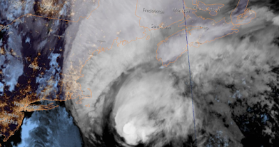
NOAA image of Hurricane Dorian located east of Cape Cod and south of Nova Scotia early Saturday morning. (NOAA)
Early Saturday morning, hurricane Dorian was located 660km southwest of Halifax, racing towards the northeast at 41km/h. Dorian has still maintained category 1 status, with winds gusting to 140km/h. Hurricane warnings are in effect for Nova Scotia and P.E.I., with tropical storm warnings posted for portions of New Brunswick, Newfoundland and eastern Quebec. Montreal and southern Quebec will have no weather impacts from Dorian.

Ocracoke Island, North Carolina was inundated by a 7 foot storm surge produced by Dorian on Friday. The tiny barrier island sustained major damage as did neigbouring Hatteras Island. (Hyde County Sheriff Office)
Waves and winds are increasing along the south coast of Nova Scotia Saturday morning, with hurricane conditions expected in Halifax by late this afternoon or this evening. At this time, most locations in the warning area should see winds of  90 to 120km/h, but gusts up to 150km/h are possible along the coast. Heavy rain will fall along and west of the track, with up to 150mm possible. Flooding will be a major concern in western Nova Scotia ans southern New Brunswick. A storm surge of  several metres is expected, especially along the south coast of Nova Scotia and in the Gulf of St. Lawrence. Waves of 5 to 10 metres are also likely in the warning area. Flooding, tree damage and power outages as well as some structural damage are major concerns today across the Maritimes. Dorian will move into Prince Edward Island tonight and across the Gulf of St. Lawrence on Sunday morning.

Dorian will  then begin to transition into a powerful post-tropical storm Sunday as the system moves rapidly across Newfoundland and into the North Atlantic.

Wednesday, September 04, 2019

Dorian devastates The Bahamas heads for the Carolina coast

Hurricane Dorian caused the complete and total destruction of most dwellings on Great Abaco and Grand Bahama Islands in The Bahamas. The storm spun over the islands for over 36 hours. (US Coast Guard Photo)
Paradise lost...
Complete, unprecedented damage is what is left behind on Great Abaco and Grand Bahama Islands after 48 hours of fierce winds and pounding seas from hurricane Dorian. The once category 5 hurricane battered the northwest Bahamas with a 20 foot storm surge and 185 mph winds through the weekend and into Monday. The damage is just incredible, with most structures simply gone. Cars and boast are submerged, power lines and trees ripped form the ground. The death toll stands at 20, but is likely to climb as rescue workers arrive in the hardest hit areas.

The US Coast Guard has conducted numerous rescues, in some cases pulling people from rooftops after several days. Both islands were completed inundated with the storm surge. Relief is pouring in from several countries including Canada, which has pledged $500,000, with additional aid to follow.

The eye of hurricane Dorian was located off the Georgia coast late Wednesday afternoon. (NOAA)
Dorian skirted the Florida coast on Wednesday, bringing storm surge flooding and heavy rain, but damage was minor. Hurricane Dorian at 8pm Wednesday evening was located 410km south southwest of Wilmington, North Carolina, with 175km/h winds. Dorian is moving northwest at 15km/h, with a gradual turn towards the northeast forecast on Thursday. The hurricane is expected to remain just offshore of the southeast US coast, perhaps making landfall along the Outer Banks of North Carolina. A hurricane warning extends northward to the Virginia border. Heavy rain in excess of 200mm is forecast along the track of the storm. Storm surge flooding is also expected along coastal areas.

Dorian to hit Atlantic Canada
By Saturday, hurricane Dorian is expected to sweep into the Maritimes with significant impacts. The Canadian Hurricane Centre is predicting winds of up to 140km/h as well as heavy rain, in excess of 50mm for portions of Nova Scotia and Newfoundland. Storm surge flooding is also expected in coastal communities. Far eastern Quebec will also receive rain and gusty winds from Dorian. Montreal will be too far west for any weather from the storm, with the exception of perhaps a gusty northeast wind filtering down the St. Lawrence Valley. The current forecast calls for Dorian to move across central Nova Scotia by late Saturday afternoon, approaching Newfoundland by early Sunday.

Sunday, September 01, 2019

Dorian strongest Atlantic hurricane in modern times to hit The Bahamas

Images shared on social media show widespread damage and flooding on Great Abaco Island in the northern Bahamas.
Hurricane Dorian became a monster storm Sunday, tearing apart Great Abaco Island for most of the day. The storm exploded early this morning, reaching category 5 status and beyond. Dorian became the strongest hurricane in modern times to strike The Bahamas, and one of the most intense on record in the Atlantic basin. Peak winds reached 185mph, and have since lowered only slightly to 180mph (285 km/h) as of the 11pm observation Sunday night.

Dorian became one of the strongest hurricanes on record in the Atlantic basin today, as winds reached 185mph. (Tropical Tidbits)
Dorian is crawling achingly slowly at 9km/h, prolonging the battering the northern Bahamas is sustaining. The slow movement has resulted in massive flooding, power outages and the complete failure of most structures. Images and video shared on social media show tremendous damage on Graeat Abaco Island. The storm is now impacting Grand Bahama Island and Freeport. Catastrophic damage is expected in those locations as the winds scour the region overnight and into Monday.

Winds and waves will increase on Labour Day along the Florida coast as Dorian inches dangerously close to a US landfall. Forecasters expect that Dorian will remain just offshore, however just a slight wobble would bring the eye inland along the central Florida coast. As of late Sunday, hurricane warnings were now in effect along the Florida coast and evacuations were ordered in several counties.

Briefly looking ahead, Dorian is expected to sweep the southeast coast as far north as the Outer Banks. While weakening is expected, Dorian will remain a very dangerous hurricane for most of the upcoming week.

Category 5 Dorian battering northern Bahamas

A textbook image of category 5 hurricane Dorian early Sunday morning. (Tropical Tidbits)
Early Sunday morning, hurricane Dorian was upgraded to a powerful category 5 storm, with winds of  260km/h (160 mph). The storm is battering the northwest Bahamas, and expected to do so through Monday. The slow moving hurricane is drifting west at 15km/h. Dorian was located 55km east of Great Abaco Island. Catastrophic damage from wind, rain and storm surge is possible with a category 5 storm.

Hurricane warnings remain in effect for the northwest Bahamas, while a tropical storm warning is in effect for the Florida coast from  Deerfield to Sebastian Inlet. A tropical storm watch is in effect north to Golden Beach. Winds and waves will begin increasing along the Florida coast late tonight and on Labour Day.

Some computer models now have Dorian remaining off the Florida coast and turning sharply north then northeast early this week. The hurricane now poses a serious threat to the North and South Carolina coast, including the extremely fragile Outer Banks. A state of emergency remains in effect for Florida, Georgia and the Carolinas.