Tuesday, November 28, 2023

Two winter storms bypass Montreal region

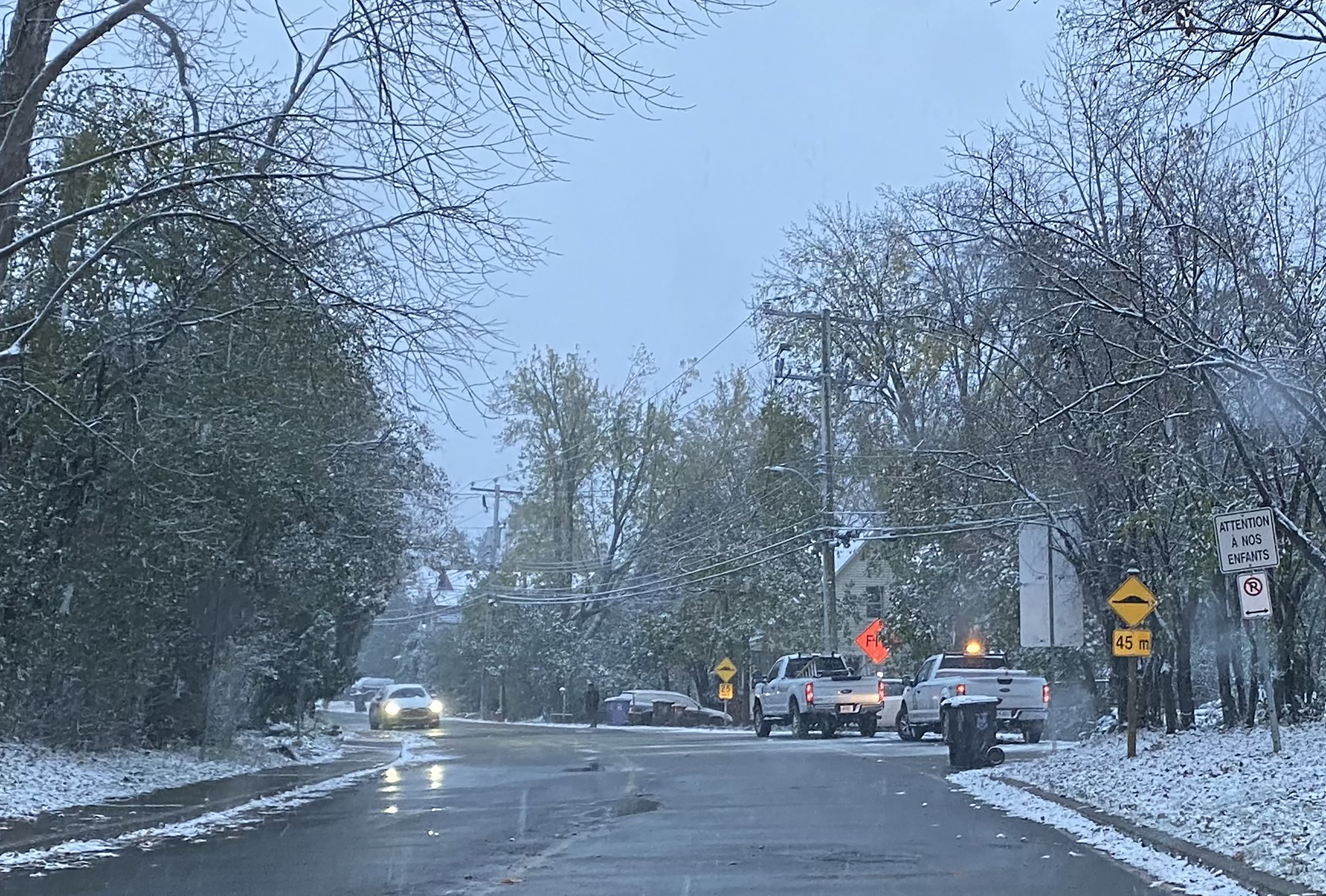
While rain fell in the Montreal region, wet snow fell in many other parts of southern Quebec including the Richelieu Valley shown above. Further east across the Beauce and Quebec City regions, the snow was heavy, with up to 30cm reported. The snow cut power to over 125,000 Hydro-Quebec customers. (Photo T. Giotsalitis)

Southwestern Quebec continues to be bypassed by the early season snow that has affected many parts of Quebec and Ontario. On Sunday evening, low pressure moved across southeastern New England generating heavy wet snow across interior portions of the northeastern US, as well as southern and eastern Quebec. Between 15-30cm of wet snow fell east of the Richelieu Valley, across the Eastern Townships, Beauce, Chaudière-Appalaches and the Quebec City region. 

The heavy wet snow stuck to trees and power lines cutting power to over 125,000 Hydro-Quebec customers, with thousands more in the dark across Vermont and northern New Hampshire. Hydro-Quebec had 150 teams on the job Monday, and the number of clients without power is down to just over 3000 Tuesday morning.

Meanwhile it was the same old story in Montreal, just mild enough for rain, with a few snowflakes mixed in. Around 10mm of rain fell in Montreal. This trend that has been present for most of the fall, is expected to continue into the upcoming weekend. Temperatures have chilled Tuesday morning in Montreal. We are in for 24-36 hours of chilly, blustery conditions, with westerly winds of 30-50km/h, and temperatures remaining below freezing. Windchill values will be in the minus teens. There will also be the chance of a few snow showers at times in Montreal, but with very little accumulations expected in the city. The cold air will not last, with another system passing to our north and west Thursday, with mild temperatures and showers.

Colder air will try to move into Southern Quebec next week, with perhaps some snow, but milder air may win out again.

Lake Effect Snow

Back to the current system, as the cold air pours across the wide open Great Lakes, heavy lake effect snow has been falling off Lake Huron into Ontario, and Lakes Erie and Ontario into western New York. Travel was nearly impossible in several locations, with between 20-40cm of fresh falling in under 24 hours. The intense snow bands were accompanied by lightning and thunder at times, with snowfall rates of over 5cm per hour observed. The lake effect snow will persist today, off Georgian Bay into Ontario as well as across western New York, along the Interstate 81 and 90 corridors. 

The snow bands were so intense at times, driven by strong westerly winds, that they reached into the Ottawa Valley and National Capital region overnight.

Tuesday, November 21, 2023

Messy mix of precipitation expected for Montreal

Allow yourself extra time for the Wednesday morning commute across southern Québec. A messy mix of precipitation is forecast, starting this evening and tapering off late Wednesday. Between 5-10cm of snow, along with freezing rain and eventually rain is expected across the entire region.

Winter Weather Advisories are in effect for northern New York, New England and Eastern Ontario. They may be extended into southern Quebec later today.

Tuesday morning was one of the coldest so far this season, with low temperatures across the southwestern Quebec generally between -5C and -10C (14F-23F). The coldest reading I could find was across the Laurentians where several locations were in the middle minus teens.

Today will be sunny and cold, with increasing northeast winds and a high temperature near the freezing point in Montreal. Low pressure will move from the central plains into the Great Lakes on Wednesday, passing well north and west of the Montreal region. A warm front advancing into Ontario and Quebec this afternoon and tonight, will set the stage for several hours of mixed precipitation.

Clouds will thicken today, followed by snow spreading across the Ottawa Valley and into southwestern Quebec late this afternoon and this evening, persisting well into the overnight period. As warmer air erodes the cold air at the surface, the snow will change to rain, with the risk of freezing rain during the transition. Before the changeover, a good 5cm of snow is possible in Montreal, with 5 to 10cm expected north of Montreal and in the Ottawa region, as well as the eastern Townships. Some higher elevations across the Townships and Vermont may see up to 15cm. Locations that see freezing rain, such as Cornwall and Massena, may se as much as 10mm of ice accretion.

As the warmer air moves into the entire region Wednesday, temperatures will rise above freezing to around 3C (38F) in Montreal, with all precipitation changing over the light rain or drizzle.

If you have travel plans on Wednesday, expect highly variable conditions, with mixed precipitation and the likelihood of snow covered and icy roads in many locations.

On Thursday, a cold front will bring in an arctic airmass that will persist Friday and into the weekend, with temperatures falling through the day, along with gusty northwest winds. A few flurries are possible as well. Temperatures will be the coldest of the season so far by Friday, dropping from 5C (41F) Thursday, down to -8C (18F) by Friday morning and remaining fairly steady during the day. The low Saturday morning will be a chilly -12C (10F).

Thursday, November 16, 2023

The Ice Bowl of 1977

Standing in the snow and cold during the 65th Grey Cup Parade in Montreal in November 1977. The photo was taken with my KODAK 110 camera, I was 11 at the time. The temperature was around -5C (23F), and heavy snow fell for the duration of the parade. It was awesome!

As we head into the CFL's 110th Grey Cup weekend, with the Montreal Alouettes set to face the Winnipeg Blue Bombers at Tim Horton's Field in Hamilton, I started thinking about the famous Ice Bowl played back in 1977.

A record-breaking crowd of 68,318 fans braved a transit strike and game time windchills in the minus 20s. (Montreal Alouettes Photo)

Weather has often presented a serious challenge to Grey Cup participants and spectators alike. The game has been held in snow, sleet, fog and serious cold. Such was the case during the 65th Grey Cup held in Montreal on Sunday, November 27, 1977. The game, dubbed the Ice Bowl, saw game time temperatures around -10C (14F), with strong northwest winds that gusted between 50 and 70km/h at times. Windchill readings were in the minus 20s. Despite that, a record-setting crowd of 68,318 fans filled Olympic Stadium, with no roof at the time, braving the cold as well an ongoing transit strike. That record crowd for a Grey Cup game still stands to this day.

Field conditions were less than ideal, but that did not stop Montreal from defeating Edmonton 41-6. (Montreal Alouettes Photo)

The cold did not stop the Alouettes from destroying the Edmonton Eskimos 41-6 behind a stellar performance by Virginia native, Quarterback Sonny Wade and kicker Don Sweet from Vancouver. Both were playing in weather that neither grew up with. 

The frigid cold had poured in behind a major early season snowstorm, that had dumped 21.3cm of snow on the city on Saturday, November 26, with blowing, drifting snow and cold temperatures. The Grey Cup Parade that always preceded the game during the 70's was held along downtown St. Catherine Street. 

I lived in Verdun at that time, and was more than eager to attend the parade, despite the weather. I was 11 years-old in 1977 and all seemed right with the world to me standing in the snow and cold outside Woolworth's downtown, with my family. We occasionally would duck in for a hot chocolate at the lunch counter to warm up. The day remains a cherished memory for me with my late father, and further solidified my interest in weather. Snowstorms of the 1970's were awesome in my eyes, and this one was even more special.

No snow is forecast this weekend in Hamilton, with the game set to start at 6pm. Expect clear skies, light winds and chilly temperatures around 2C (35F), perfect football weather in Canada. Enjoy the game, GO ALS GO!

The snow intensified as temperatures dropped towards the end of the Grey Cup Parade in Montreal on November 26, 1977. (ValleyWeather)


Friday, November 10, 2023

Cold weekend ahead - but warmer weather on the way

The first significant snowfall of the season on Thursday produced a record-breaking 7cm of wet snow across the Montreal region. The snow iced roads and bridges leading to several major accidents and significant traffic delays. Conditions have vastly improved Friday morning. (Valley Weather)

A bulk of the 7cm of snow that fell in Montreal Thursday is gone already early Friday morning. The temperature has risen well above the freezing point and sits at 4C (39F) currently. We can expect a mild, windy high of 7C (45F), with winds out of the southwest 30-50km/h.

A cold front arrives this evening, setting the stage for a chilly weekend. Along the front look for scattered showers and flurries, followed by clearing skies and cold temperatures. Morning lows on both Saturday and Sunday will be down to -3C (27F) in the Montreal region.

Another round of showers is possible early next week, but the main story will be warming temperatures. Winter is not yet ready to take over. As a matter of fact, November is looking like a typical El Nino month, with more warm and dry days expected than wintry ones. This will give motorists a few more weeks to prepare for winter, because quite clearly many were not on Thursday.

The snow that fell quickly iced roads, especially elevated surfaces. The result was the typical nonsense that greets drivers every year as the first flakes fly. Numerous accident were reported, along with major delays during the morning commute. Conditions improved in the afternoon as temperatures warmed to the freezing point and the precipitation came to an end. Get those snow tires on!

The 7cm of snow that fell on Thursday at Trudeau Airport set a new daily record for November 9, surpassing the previous benchmark of 1.8cm set in 1952.

Wednesday, November 08, 2023

Snow and freezing rain for the Thursday morning commute

After a very mild October, many parts of Quebec have been thrown straight into winter. Heavy snow fell across portions of central Quebec on Monday and Tuesday, with more snow forecast Thursday, this time including Montreal and southern Quebec.
Expect wintry precipitation and slippery roads for the Thursday morning commute in Montreal and across the entire region.

A messy mix of snow and freezing rain is on the way for the Thursday morning commute from Ontario into southwestern Quebec. A clipper system from western Canada will move across the Great Lakes and down the St. Lawrence Valley. Typically these storms are moisture starved, but can benefit from the Great Lakes.

This system will provide many regions with the first snow and ice of the season. Special Weather Statements and Winter Weather Advisories have been issued for a wide swath of southern and eastern Ontario as well as New York and New England. They will likely be extended into portions of Quebec later today.

In terms of weather, Wednesday will be fair, but chilly, with a gusty northwest winds of up to 50km/h. Tonight will start off clear, with temperatures dropping quickly after sunset before levelling off neat midnight. The early low will be -5C (23F) in Montreal. That cold air will set the stage for a burst of snow before sunrise, with up to 5cm possible for many locations. The snow will eventually mix with and change to freezing rain and rain from south to north. Precipitation should taper off to drizzle in the afternoon, with temperatures rising above freezing to 3C (38F).

Friday looks a touch milder, up to 6C (43F). The weekend at this time will be cooler, but dry. Briefly looking ahead to next week, our taste of winter looks brief as mild temperatures are set to return.

Tuesday, November 07, 2023

Rare November thunderstorms followed by snow

A few rare nocturnal November thunderstorms developed in advance of a cold front early Tuesday morning across the Montreal region. Much colder air and more snow is on the way by Thursday.

Much colder air arrives in Montreal later today, followed by up to 5cm of wet snow Thursday.

Montreal had a few surprise thunderstorms during the pre-dawn hours Tuesday, along with viid lightning and some heavy but very brief rainfall. The culprit is a clipper-type low pressure system and cold front over the Ottawa Valley, slicing southeast into some moderately unstable air. Temperatures are quite warm this morning, around 10C (50F) here on Ile Perrot. This will likely be the high for the day, as cooler air begins to filter into the St. Lawrence Valley later this morning on gusty northwest winds of up to 50km/h.

Temperatures will fall all day, down to below freezing this evening at -1C (30F) in Montreal. Wednesday will be partly sunny, but breezy and much cooler, with a high of only 3C (38F). That cooler air will set the stage for some mixed precipitation across eastern Ontario and western Quebec starting during the overnight hours into Thursday morning. Another Alberta Clipper will slide across the Great Lakes and St. Lawrence Valley bringing a swath of snow and rain to the region.

The temperature will be marginally cold enough in Montreal for snow to start, likely mixing with and changing to rain at some point Thursday. At this time, up to 5cm of wet snow may fall in several regions of southern Quebec, more to the north of the city and less south towards the US border.

There are still some details to work out, and this will not be a big storm by any stretch. However, November snowfalls can be very tricky and certainly can make driving challenging. Allow extra time for the Thursday morning commute.