Monday, April 30, 2012
Warmer week ahead
High pressure over the weekend provided us with a sunny and dry couple of days. Unfortunately it was cold and windy as well. Gusty northwest winds help to make it feel much colder than the plus 8 or 9C highs Montreal had. Frost warnings were posted all weekend but here on L'Ile Perrot those same winds managed to keep away the frost. It was chilly with lows below freezing the last three mornings including -1C this am. The only frost I managed to see was a little on the car this morning. It will warm quickly today under sunny skies and light winds to around 15C. The balance of the week will be somewhat unsettled but mild. We are looking at showers on Tuesday as a system passes well south of the border. Wednesday we may see some partial clearing before another round of showers and even some thunderstorms Thursday and Friday. It will be warm however with temperatures rising to near 20C by mid week.
Friday, April 27, 2012
Frost Warning
 |
| Overnight lows in degrees Fahrenheit for the border region. It will be cold with widespread frost in Quebec, Ontario and New England tonight. (NWS Burlington) |
Cold high pressure is settling in behind a departing cold front and low pressure this morning. The storm system that gave the region rain last night is now strengthening over southern Maine. It is forecast to move across Atlantic Canada with heavy rain and even some snow across the lower St. Lawrence and Gaspe area.
Meanwhile in its wake much colder air is settling across southern Quebec and Ontario this morning. Temperatures have fallen with strong northwest winds this morning into the -1 to plus 3C range. With the wind it feels even colder making it rather raw and chilly for late April. Toss in a few snowflakes and we have an unseasonable Friday ahead of us. Things will clear out for the weekend with sunny and dry weather expected but it will be cold. Environment Canada has posted frost warnings for southwestern Quebec and the National Weather Service has them in effect for the St. Lawrence and Champlain Valley's of New York and Vermont where the growing season has started early. Overnight lows will drop to the -5 to -8C range, well below normal, and likely providing a heavy frost if not a solid freeze. If you have anything growing, cover them up to save them. High temperatures across the area under sunny skies will be cold, no warmer than 10C on both Saturday and Sunday.
Thursday, April 26, 2012
Finally a little sun
 |
| Over 20cm of snow fell in Orangeville, Ontario on Monday. CBC News |
It has been a dismal weather week with lots of clouds, showers, wet snow and even some small hail since Monday's strong storm moved across the region. That system is now well north of us over Hudson Bay giving blizzard conditions to far northern Quebec. Most of us had more rain from that storm in 24 hours than we had seen in the entire month of April. I measured around 42mm here on L'Ile Perrot with closer to 30mm at the airport. Just a trace of snow fell in Montreal, but as much as 10cm fell down the 401 in the Thousand Islands and over 20cm west of Toronto in Orangeville. The snow created a bunch of accidents closing the 401 for a spell as well as cancelling school buses for thousands of students in Ontario. Despite everybody being shocked, a glance at the record books shows it was not that unusual with many historic mid and late April snowstorms over the years in Ontario and Quebec.
Today we start of with some sunshine and chilly temperatures with a light frost here on L'Ile Perrot at 0C. We will have some brief sunshine however clouds are on the increase once again as low pressure in the Ohio Valley moves northeast across New York. Temperatures may warm to around 10C or so today. Look for rain to develop later today with winds increasing to 20-40km/h. Rain overnight may mix with a few flurries before ending by morning. Another 15-20mm of rain is likely as we continue to balance the precipitation books for the month. Slow clearing arrives Friday followed by a sunny but chilly weekend with cold lows well below freezing. If you planted early be prepared to protect that vegetation this weekend as widespread frost and freezing temperatures are likely across the entire area including metro regions. It will slowly warm up next week as we welcome May and hopefully real spring.
Monday, April 23, 2012
Nor'Easter continues
** The weather has resulted in school bus cancellations across Stormont, Dundas and Glengarry Counties in Ontario as well as Cornwall and some in Leeds & Grenville.
Heavy Rain Warning for Montreal today.
High wind advisory for the St. Lawrence Valley
Snow in Ottawa.
It will be a stormy day today across western Quebec, Eastern Ontario and New England as strong low pressure lifts north from the Jersey Shore into the central Adirondacks later today. Overnight Montreal had a mix of rain and very wet snow with a slushy coating on my car this morning that is rapidly being washed away. The rain was heavy at times with close to 30mm or over 1 inch here on L'Ile Perrot since 10pm. Temperatures were as low as 1C and are at a chilly plus 2C (36F) now. Winds are strong out of the northeast at 50km/h with a peak gust overnight to 71km/h at Trudeau Airport and they will continue to gust to 70km/h today.
While enough warm air is in place in Montreal for rain you do not have to go very far west to have snow. Along and west of the 416 corridor in Ontario including Ottawa a heavy wet snow has visibility down to 1km at times. From Prescott north through Kemptville to Ottawa and west a good 2-5cm of snow has fallen and will continue to fall today while mixing with rain at times. Roads are snow covered in places and travel is slow. It is raining in Toronto but south of the GTA in the Niagara Region and western New York heavy snow is developing and will accumulate 5 to 10 inches (up to 25cm) locally. The heavy nature of the snow will bring down trees and power lines. There is even a good chance of some thunder with the snow at times.
As the low moves northward a pronounced dry slot is working its way into the Champlain Valley and north towards Montreal. As a result we may see a break in the precipitation in Montreal later this morning. Look for a generally wet and windy day across the region with highs near 10C for Montreal south and east and between 2 and 5C for points north and west.
Heavy Rain Warning for Montreal today.
High wind advisory for the St. Lawrence Valley
Snow in Ottawa.
 |
| The Nations Capital barely visible under a wet blanket of snow at 7am. |
While enough warm air is in place in Montreal for rain you do not have to go very far west to have snow. Along and west of the 416 corridor in Ontario including Ottawa a heavy wet snow has visibility down to 1km at times. From Prescott north through Kemptville to Ottawa and west a good 2-5cm of snow has fallen and will continue to fall today while mixing with rain at times. Roads are snow covered in places and travel is slow. It is raining in Toronto but south of the GTA in the Niagara Region and western New York heavy snow is developing and will accumulate 5 to 10 inches (up to 25cm) locally. The heavy nature of the snow will bring down trees and power lines. There is even a good chance of some thunder with the snow at times.
As the low moves northward a pronounced dry slot is working its way into the Champlain Valley and north towards Montreal. As a result we may see a break in the precipitation in Montreal later this morning. Look for a generally wet and windy day across the region with highs near 10C for Montreal south and east and between 2 and 5C for points north and west.
Sunday, April 22, 2012
Heavy rain & snow
 |
| NOAA image this afternoon of the developing storm over the Atlantic Ocean near Cape Hatteras. Heavy rain and snow will spread north and west. |
The same storm is forecast to dump heavy rain up and down the eastern seaboard with coastal flooding all the way north into Atlantic Canada. Southern New Brunswick could see 100mm (4 inches) of rain with freezing rain across the north. In central Quebec heavy snow is forecast. This is a developing storm with still some uncertainty so check back later this evening.
Friday, April 20, 2012
Wet weekend update
It is chilly in Montreal this morning with some showers draped along the Quebec/Vermont border. A warm front will try to push north of Montreal today, until it does we will have northeast winds and chilly highs of around 9C. Once the front moves north of the city we should see a brief shot of warm air on Saturday that could push temperatures up to 18C. It will be short lived as a cold front and low pressure area will give rain late Saturday into Sunday. The big weather story then begins late Sunday night and lasts well into next week. A rather large coastal storm will develop near the Delmarva and move north and begin to affect New England, Quebec and Ontario. Lots of precipitation, as much as 50mm or more along with strong winds and cool temperatures are expected to start the work week. There is even a growing possibility of wet snow for some of us. The exact track and intensity of the storm is yet to be determined, so there are lots of details to sort out. Look for cloudy, damp and cool weather until at least Wednesday of next week.
Thursday, April 19, 2012
Enjoy today - a wet weekend ahead
It will be another spectacular spring day in Montreal with a warmer southwest wind developing and temperatures rising rapidly to around 20C (68F) this afternoon. That will be quite a bit warmer than Wednesday when the mercury reached 11C in the city and around 12 to 15C off island. That high pressure will slowly drift off the Atlantic coast today allowing low pressure and a stationary front to establish itself over the area for the upcoming weekend. The first system in Michigan today will move along the international border on Friday with a period of showers and much cooler weather here in Montreal. By Saturday a cold front will approach the area with widespread rain expected. We may see some brief partial sunshine on Sunday before a much larger storm develops off the east coast near Virginia and moves north. This system will be the first coastal storm in quite some time to affect the region. Gusty winds, chilly temperatures and widespread rainfall, possibly up to 50mm (2 inches) may fall late Sunday into Monday. There is even a risk of some wet snow for places like the Adirondacks in northern New York. The track and details are still a little up in the air, but we do need the rain desperately in the area, so it would be welcome. In any event today will be near perfect - so get out and enjoy.
Wednesday, April 18, 2012
Frosty morning
It is hard to believe we are sitting below freezing in Montreal, Ottawa and Toronto this morning after reaching nearly 30C (86F) on Monday. But here we are back to the gloves with a touch of frost on the ground and certainly on your front windshield. High pressure settled into southern Quebec and Ontario overnight with calm winds and cold temperatures. A widespread frost and in some cases a freeze has occurred across Michigan and Ontario south into Ohio and New York as well as most of Quebec. It could be worse, snow is still on the ground across northwest Ontario with as much as 40cm in some locations. Another round of snow, likely 10cm or so is forecast later today for that same area.
Our weather will be controlled by high pressure into Friday with warming temperatures and just some high cirrus clouds. By Friday the weather will become increasingly stormy into the weekend and early next week. A complicated collection of systems will begin to affect southern Quebec, the most important being a potent low pressure area moving from the Gulf of Mexico up the eastern seaboard. This storm will have the potential to produce heavy rain with up to 50mm (2 inches) possible along the track. It is much needed rain so it will be welcomed to help lower the recent fire threat. It will however mean a wash out for the weekend at this time. Winds will be gusty and it will be chilly. It may even be cold enough for some wet snow in some elevated location and north of Montreal, but we will look at that a little closer as we move towards the weekend. In the meantime enjoy the sunshine, it will warm to 12C today and up to 18C on Thursday.
 |
| From AccuWeather.com a look at this weekends potential storm track. |
Tuesday, April 17, 2012
Summer vs Winter
UPDATE 12:30PM: I have two more record highs to add to the list, Kemptville hit 28.3C yesterday breaking the old record of 27.6C set in 2002, and Brockville was 28.4C, the old record from 1973 was 24.4C. Today, just 24 hours later, most places are in the cold plus 9 to 11C (48-52F) range with a strong west wind. From shorts to gloves!
SUMMER
I really did not think we had a chance, but there it is, a new official record high for April 16 of 28.9C (85F) at Trudeau Airport, squeaking past the old record of 28.7C set in 2002. By my count that makes 6 record highs already this year for Montreal. There were dozens of other records smashed including 31.4C (88F) at St Anicet, 29.9C (86F) at St Anne's on the West Island and 29C (85F) at Lennoxville. I was at 31C here on L'Ile Perrot, and we had around 10mm of rain with the front last night. Temperatures all over the region nudged into the high 20's and low 30's, normal for mid July. Burlington, Vermont was still at 27C (80F) last night at 11pm! A strong cold front has chilled things way down this morning as we sit at 12C (54F) with a gusty west wind up to 50km/h. Temperatures will not move much today staying in the 13 to 15C range, but with plenty of sunshine. Winds will abate this evening and temperatures will drop to near freezing. As a matter of fact freeze warnings and watches are in effect for a large area of western New York and Ohio where the growing season is well underway.
That same cold front was the focus for strong southwest winds ahead of it on Monday. Winds gusted to over 95km/h across most of southern Ontario including 96km/h at London and Hamilton with 70 and 80km/h gusts in the GTA. The winds toppled trees, power lines and signs knocking out power to thousands of homes and businesses. It even knocked over a semi-truck on Highway 400 north of Toronto. The front also produced some scattered thunderstorms, but only showers rolled through Montreal in the middle part of the evening.
WINTER
The parent low pressure area of that cold front meanwhile was producing heavy snow and freezing rain across northern Minnesota into northwest Ontario including Thunder Bay where 3 hours of freezing rain was reported. In Timmins over 14 hours of ice snarled traffic and cut power. Atikokan had snow and lots of it with 27cm, while Kapuskasing recorded 32cm. The OPP had to close the Trans Canada Highway near Wawa because of severe winter weather.
SUMMER
I really did not think we had a chance, but there it is, a new official record high for April 16 of 28.9C (85F) at Trudeau Airport, squeaking past the old record of 28.7C set in 2002. By my count that makes 6 record highs already this year for Montreal. There were dozens of other records smashed including 31.4C (88F) at St Anicet, 29.9C (86F) at St Anne's on the West Island and 29C (85F) at Lennoxville. I was at 31C here on L'Ile Perrot, and we had around 10mm of rain with the front last night. Temperatures all over the region nudged into the high 20's and low 30's, normal for mid July. Burlington, Vermont was still at 27C (80F) last night at 11pm! A strong cold front has chilled things way down this morning as we sit at 12C (54F) with a gusty west wind up to 50km/h. Temperatures will not move much today staying in the 13 to 15C range, but with plenty of sunshine. Winds will abate this evening and temperatures will drop to near freezing. As a matter of fact freeze warnings and watches are in effect for a large area of western New York and Ohio where the growing season is well underway.
 |
| Still serving fresh coffee, but the Tim's sign was no match for 100km/h wind gusts in Hamilton on Monday. (The Spectator) |
WINTER
The parent low pressure area of that cold front meanwhile was producing heavy snow and freezing rain across northern Minnesota into northwest Ontario including Thunder Bay where 3 hours of freezing rain was reported. In Timmins over 14 hours of ice snarled traffic and cut power. Atikokan had snow and lots of it with 27cm, while Kapuskasing recorded 32cm. The OPP had to close the Trans Canada Highway near Wawa because of severe winter weather.
Monday, April 16, 2012
Near record warmth - tornadoes
 |
| An all too familiar scene this spring is repeated this weekend across Oklahoma. Below right a tornado late Saturday in western Oklahoma. |

Saturday, April 14, 2012
Titanic 100 Year Anniversary
 |
| The ghostly image of the Titanic 2.5 miles below the frigid waters of the North Atlantic nearly 400 miles off the Nova Scotia coast. |
The distress call from RMS TITANIC at 11:55 PM, April 14, 1912. (Position Lat. 41.46 N Long. 50.14 W)
As I write this entry it is almost the exact moment 100 years ago that the SS Titanic out of Southampton, England hit an iceberg that would eventually lead to her sinking around 2:40am on the 15th of April, 1912. Sadly, as we all know 1500 souls were lost on that terrible night. By all accounts the voyage to that point was uneventful in the weather department. The waters of the Atlantic had been calm with sunny, mild days and starlit nights. The same held true the night of the collision, maybe a little too calm. The presence or lack there of any weather, or moon (new moon) for that mater would mean that any ice would have been difficult to spot. In addition to the calm, mirror like seas, it was a very cold night. The Titanic had sailed through a cold front earlier in the day that had left her in air temperatures right around the freezing point by 11:40pm. The water was frigid by some estimates almost as cold as -2C (28F). Sea water can reach temperatures below 0C without freezing due to the salt content. In water temperatures such as these survival would have been nearly impossible with death in minutes.
By comparison that night, Montreal was plus 5C (41F) on the 14th and dropped below freezing overnight. In St. John's, Newfoundland, the closest major centre to the Titanic disaster, cold temperatures prevailed behind the cold front with highs of plus 3C (38F) on the 14th and plus 4C (39F) on the 15th. In Halifax where many of the dead from Titanic are buried, and rescue and recovery efforts were launched, it was a mild 10C (50F) on the 14th. Temperatures in Halifax dropped quickly behind the same cold front that the Titanic had encountered, down to -4.4C (25F) by the morning of the 15th showing how cold the air was in the region. New York City where the Titanic was expected was also chilly and clear on the 15th.
Friday, April 13, 2012
Weekend Update
After the clouds, showers and hail of this past week, we have a spectacular Friday and Saturday on tap for southern Quebec and eastern Ontario. Sunshine today will allow temperatures to rebound nicely from near the freezing point this morning up towards 16C (61F) by this afternoon. Nothing but sunshine today with fairly light westerly winds. Winds will increase overnight and Saturday as a frontal system approaches from the southwest. Overnight lows will be milder than this morning, remaining around 5C (41F). On Saturday look for a breezy day with partial sunshine and highs near 16C once again. That frontal boundary will move into the region on Sunday with a few showers and perhaps a thunderstorm. Winds will be gusty up to 40km/h and highs will be near 17C (63F). On Monday a warm front will lift north of the region putting most of Ontario, New England and extreme southern Quebec in some very warm and even humid air. Highs will soar to around 23C (73F) in Montreal but as warm as 26C (79F) in parts of the St. Lawrence Valley. A cold front late in the day may trigger some showers and perhaps a rumble of thunder.
 Sunday, April 15 in the wee hours of the morning, we mark a somber event, the 100th anniversary of the sinking of the HMS Titanic. The ship went down in under three hours after striking an iceberg. Nearly 1500 souls were lost that terrible night. Tomorrow's blog entry will feature a brief look at the weather that night not only at the crash site but also for comparison along the coast and here in Montreal.

Wednesday, April 11, 2012
One more showery day
We continue to have an upper level low spinning near Quebec City, the same one that was over the Atlantic Ocean last weekend. It will slowly drift south into northern Vermont today and eventually east back out to sea by Thursday. Here in southern Quebec and across eastern Ontario we are looking at one more day of showers. Yesterday afternoon the radar image resembled a popcorn machine with little kernels of instability bubbling up all over the place in the cool and humid air. We can expect the same today with a few very small sunny breaks early in the day followed by scattered to numerous showers and even some small hail. We did have a little hail in the late afternoon here on L'Ile Perrot yesterday.
This will be the last day of showers with a very slow clearing forecast for Thursday and warm sunshine by Friday. The temperature will be 10C today, followed by lows near 1C tonight. Friday and into the weekend we can expect much warmer highs near 16C.
The big precipitation with this system has been falling across the high peaks of the Green Mountains. The oragraphic lift created by the northwest winds has produced steady and at times heavy snow showers with 19 inches so far at Killington Mountain and 15 inches at Jay Peak. The snow has been a blessing it what was otherwise a poor ski season in Vermont. It has allowed both resorts to open trails and welcome hoards of skiers looking for a final run. This was the biggest snowfall of the season in Killington.
This will be the last day of showers with a very slow clearing forecast for Thursday and warm sunshine by Friday. The temperature will be 10C today, followed by lows near 1C tonight. Friday and into the weekend we can expect much warmer highs near 16C.
 |
| Skiers enjoying the 19 inches of fresh powder at Killington, Vermont on Tuesday. |
Tuesday, April 10, 2012
Fire & Ice
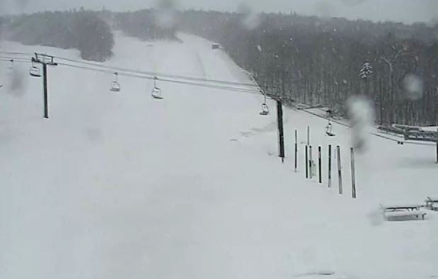 |
| The Killington web cam this morning showing over 1 foot of fresh snow down on the hills and still falling. |
 |
| Large wildfires continue to burn in the dry brush of Long Island and New Jersey. (esaphotos) |
Monday, April 09, 2012
Showers or flurries & chilly
 |
| Low pressure is moving west into southern Quebec this week with flurries & showers. |
The week starts off chilly with clouds, showers and temperatures in the 8C range for highs and 2 or 3C for lows in eastern Ontario and southwest Quebec. There may even be a few snowflakes across the regions northeast of Montreal and in the mountains of Vermont and New York. Stubborn low pressure that dealt the Maritimes an Easter Sunday snowstorm is retrograding (in weather terms, basically moving the wrong way) west towards northern Maine and eventually northern Vermont or extreme southern Quebec. It will take most of the week for the pattern to resume a more normal flow and sweep the low pressure area back east and out to sea. Until then look for lots of clouds, temperatures below normal, a chilly wind and showers scattered around at any time into at least Wednesday if not Thursday.
 |
| From CBC.ca, snow covered Easter flowers in Chester, Nova Scotia. |
Friday, April 06, 2012
Weekend Update - AB snow
 |
| Edmonton and portions of Alberta were hit by a big snowstorm on Thursday. (Edmonton Sun) |
The weather has become active again for portions of Canada. First we had a big storm slide north across Alberta on Thursday. The system dumped a heavy wet snow on Edmonton with 10cm at the airport but as much as 25cm in portions of the city. Calgary had 10cm. Visibility was very poor most of the day and numerous power outages were reported as wires came down under the weight of the snow.
This morning another strong storm is moving from Montana north into Saskatchewan by later today. The deepening low pressure area will give heavy snow and increasing north winds to Montana and southern Saskatchewan. Snow will accumulate between 15 and 30cm locally with winds gusting to 70km/h producing poor travel. The National Weather Service in Glasgow, Montana has issued a Blizzard Warning for this afternoon and tonight and is advising against travel overnight. Winter Storm Warnings are in effect for Moose Jaw and southwest Saskatchewan.
Meanwhile the weather in Montreal and southern Quebec will be controlled by advancing high pressure that will provide a sunny but chilly Good Friday. Later today, low pressure will be gathering steam along the east coast near the Outer Banks of North Carolina. This storm will move north and then west into eastern Quebec by Sunday. A maritime block is preventing this system from moving northeast and it may actually back (retrograde) into Quebec by Monday. We could see an increase in winds and cloud cover by late Sunday along with some showers of flurries to start next week.
If you think Montreal is immune to big April snowstorms, think again. There have been many but one that stands out for me was between April 3-6, 1975. Montreal had a massive winter storm (primarily on April 3rd) with 33cm of snow, winds gusting to 87km/h and visibility of under 1km for nearly 15 hours. The pressure bottomed out at 983mb as this big storm swept from the US Midwest across the Ohio Valley and into southern Quebec.
Wednesday, April 04, 2012
Dallas tornado - Alberta snow
There is weather out there despite the calm nature of things here in southern Quebec. Skies were partly cloudy on Tuesday with temperatures around 10C. We will see much the same today with partly cloudy skies but an outside chance of a shower or two as a weak cold front advances across the region. Winds are forecast to increase this afternoon to between 30-50km/h from the northwest. They will continue into the overnight with a chilly low of 0C. The Easter long weekend at this time looks perfect with slightly above normal temperatures and bright sunshine all weekend.
You have to head south or west to find the active weather. Strong low pressure in the Rockies was responsible for driving a potent cold front across Texas on Tuesday. That combined with deep moisture from the Gulf of Mexico set up the perfect conditions for severe weather. At least two large tornadoes swept across the Dallas/Fort Worth metroplex with widespread damage reported. One storm near Lancaster, Texas was filmed throwing large semi trucks into the air as if they were no more than toys. According to CNN and lot owner Wisconsin-based Schneider National Trucking Co. there were no injuries at the facility, but there was significant damage to the building and equipment. A tractor weighs 20,000 pounds. An empty trailer weighs 14,000 pounds, while a full one weighs about 46,000, the company said. Unreal power! Nearly 150 homes were damaged in Arlington, Texas and 110 aircraft were damaged at the Dallas/Fort Worth Airport forcing its closure and stranding thousands of passengers. The National Weather Service said that between 6 and 12 tornadoes occurred in north Texas with teams spreading out today to survey damage and solidify the total. Despite the ferocity of the storms only three injuries have been reported so far.
SNOW: Meanwhile in Alberta it is a return to winter with heavy snow forecast for Calgary and Edmonton as well as the surrounding areas of northern and western Alberta tonight and Thursday. A low pressure moving north through the province will give 10-20cm of snow to the region with strong winds causing near zero visibility in blowing snow. Just another spring day in Alberta.
 |
| A fierce tornado near Lancaster, Texas on Tuesday. |
 |
| From WFAA Dallas, a semi is thrown through the air with ease during a tornado on Tuesday. |
Monday, April 02, 2012
Chilly start to day
Yesterday's rain combined with temperatures just below freezing early this morning have created the ideal ingredients for black ice. Combine that with the morning rush hour traffic and the result has been numerous accidents including a multi-vehicle collision that has closed Highway 20 in Pointe Claire on the West Island of Montreal. It is just a very thin layer but still enough to ice the roads and make driving very dangerous. It will melt quickly with the rising sun, however for the moment it remains slippery as we sit at -3C here on L'Ile Perrot.
Montreal had between 3 and 5mm of rain on Sunday as a weak weather system moved southeast across the region. It has been replaced today by high pressure that will provide us with sunny skies and seasonable highs at 8C into Tuesday. Another weak area of low pressure will move across the area on Wednesday following a similar path as yesterday's low and providing southern Quebec and the region with a few flurries or showers. Afterwards we are looking at stronger high pressure settling in for the Easter Long Weekend, and providing the entire area with sunny skies and warming temperatures to near 16C by Easter.
Montreal had between 3 and 5mm of rain on Sunday as a weak weather system moved southeast across the region. It has been replaced today by high pressure that will provide us with sunny skies and seasonable highs at 8C into Tuesday. Another weak area of low pressure will move across the area on Wednesday following a similar path as yesterday's low and providing southern Quebec and the region with a few flurries or showers. Afterwards we are looking at stronger high pressure settling in for the Easter Long Weekend, and providing the entire area with sunny skies and warming temperatures to near 16C by Easter.
Subscribe to:
Posts (Atom)